
Mid layer north of DR is saturated.
Drop 31
https://www.tropicaltidbits.com/recon/r ... sondes.png
https://www.tropicaltidbits.com/recon/r ... 5-1118.png
NATL: IMELDA - Post-Tropical - Discussion
Moderator: S2k Moderators
-
TampaWxLurker
- Tropical Storm

- Posts: 196
- Joined: Thu Aug 01, 2024 8:20 am
-
cycloneye

- Admin

- Posts: 149712
- Age: 69
- Joined: Thu Oct 10, 2002 10:54 am
- Location: San Juan, Puerto Rico
Re: NATL: INVEST 94L - Discussion (70/90)
2 likes
Visit the Caribbean-Central America Weather Thread where you can find at first post web cams,radars
and observations from Caribbean basin members Click Here
and observations from Caribbean basin members Click Here
-
Blown Away

- S2K Supporter

- Posts: 10253
- Joined: Wed May 26, 2004 6:17 am
Re: NATL: INVEST 94L - Discussion (70/90)
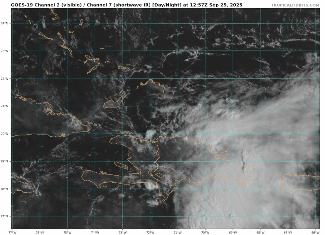
12z 20.0N / 70.7W
Do we think that naked broad swirl is the circulation moving @WNW from @20.0N / 70.7W??
0 likes
Hurricane Eye Experience: David 79, Irene 99, Frances 04, Jeanne 04, Wilma 05… Hurricane Brush Experience: Andrew 92, Erin 95, Floyd 99, Matthew 16, Irma 17, Ian 22, Nicole 22…
-
cycloneye
- Admin
- Posts: 149712
- Age: 69
- Joined: Thu Oct 10, 2002 10:54 am
- Location: San Juan, Puerto Rico
Re: NATL: INVEST 94L - Discussion (70/90)
Blown Away wrote: https://i.postimg.cc/hvwmYmSr/goes19-vi ... 251257.gif12z 20.0N / 70.7W
Do we think that naked broad swirl is the circulation moving @WNW from @20.0N / 70.7W??
We will find out the exact position when recon goes this afternoon.
0 likes
Visit the Caribbean-Central America Weather Thread where you can find at first post web cams,radars
and observations from Caribbean basin members Click Here
and observations from Caribbean basin members Click Here
-
TomballEd
- Category 5

- Posts: 1319
- Age: 62
- Joined: Wed Aug 16, 2023 4:52 pm
- Location: Spring/Klein area, not Tomball
Re: NATL: INVEST 94L - Discussion (70/90)
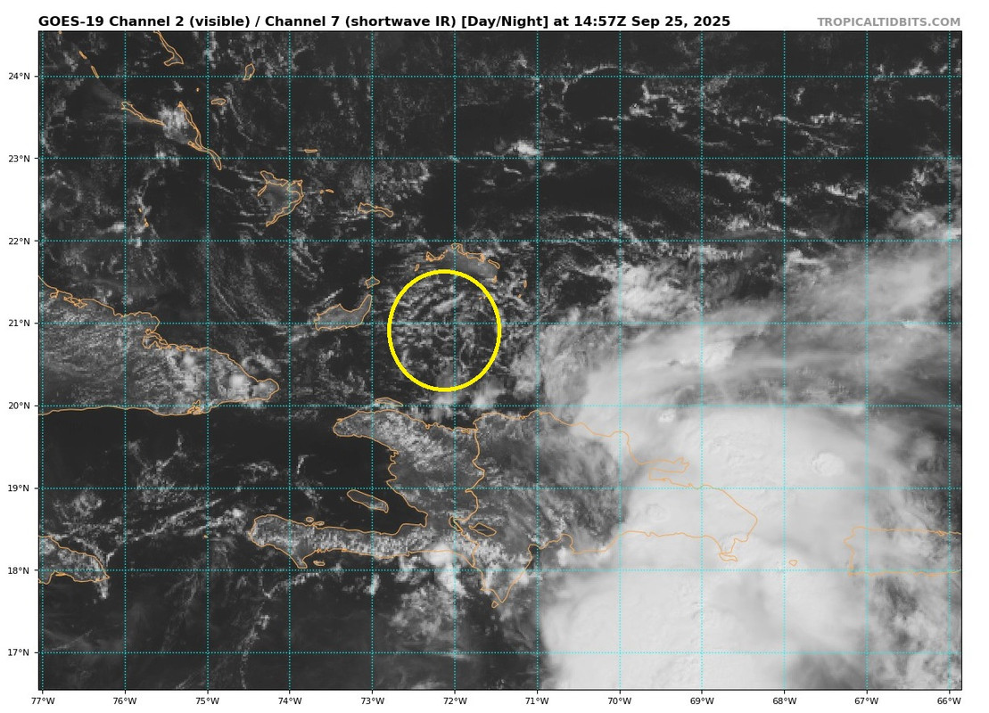
Looking at Weather Nerds satellite with lightning, and although there is a circulation north of La Republica Dominicana/Haiti, the storms are all south of Hispaniola and I wouldn't be shocked if a new center developed under the storms. I don't know how much drying occurs down sloping from the mountains but that would add extra difficulties for the low level center from developing storms.

1 likes
-
ScottNAtlanta

- Category 5
- Posts: 2535
- Joined: Sat May 25, 2013 3:11 pm
- Location: Atlanta, GA
Re: NATL: INVEST 94L - Discussion (70/90)
Hispaniola topography. Note that the eastern side is not as mountainous

1 likes
The posts in this forum are NOT official forecast and should not be used as such. They are just the opinion of the poster and may or may not be backed by sound meteorological data. They are NOT endorsed by any professional institution or storm2k.org. For official information, please refer to the NHC and NWS products.
-
Blown Away
- S2K Supporter
- Posts: 10253
- Joined: Wed May 26, 2004 6:17 am
Re: NATL: INVEST 94L - Discussion (70/90)
 how to upload photo on internet
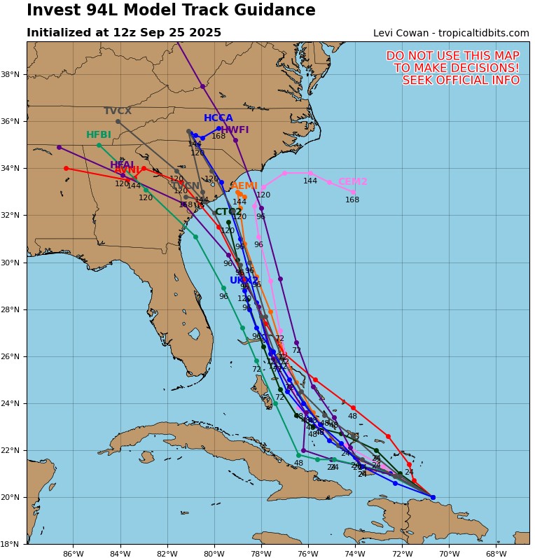
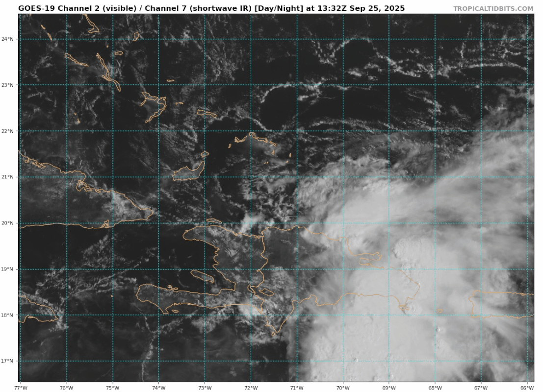
12z Position was 20N/70.7W and this swirl is moving quickly well S and W of 12z guidance?
1 likes
Hurricane Eye Experience: David 79, Irene 99, Frances 04, Jeanne 04, Wilma 05… Hurricane Brush Experience: Andrew 92, Erin 95, Floyd 99, Matthew 16, Irma 17, Ian 22, Nicole 22…
-
BensonTCwatcher

- Category 5
- Posts: 1050
- Joined: Sat Aug 28, 2004 10:11 pm
- Location: Southport NC
Re: NATL: INVEST 94L - Discussion (70/90)
cycloneye wrote:Blown Away wrote:[url]https://i.postimg.cc/hvwmYmSr/goes19-vis-swir-94-L-202509251257.gif [/url]12z 20.0N / 70.7W
Do we think that naked broad swirl is the circulation moving @WNW from @20.0N / 70.7W??
We will find out the exact position when recon goes this afternoon.
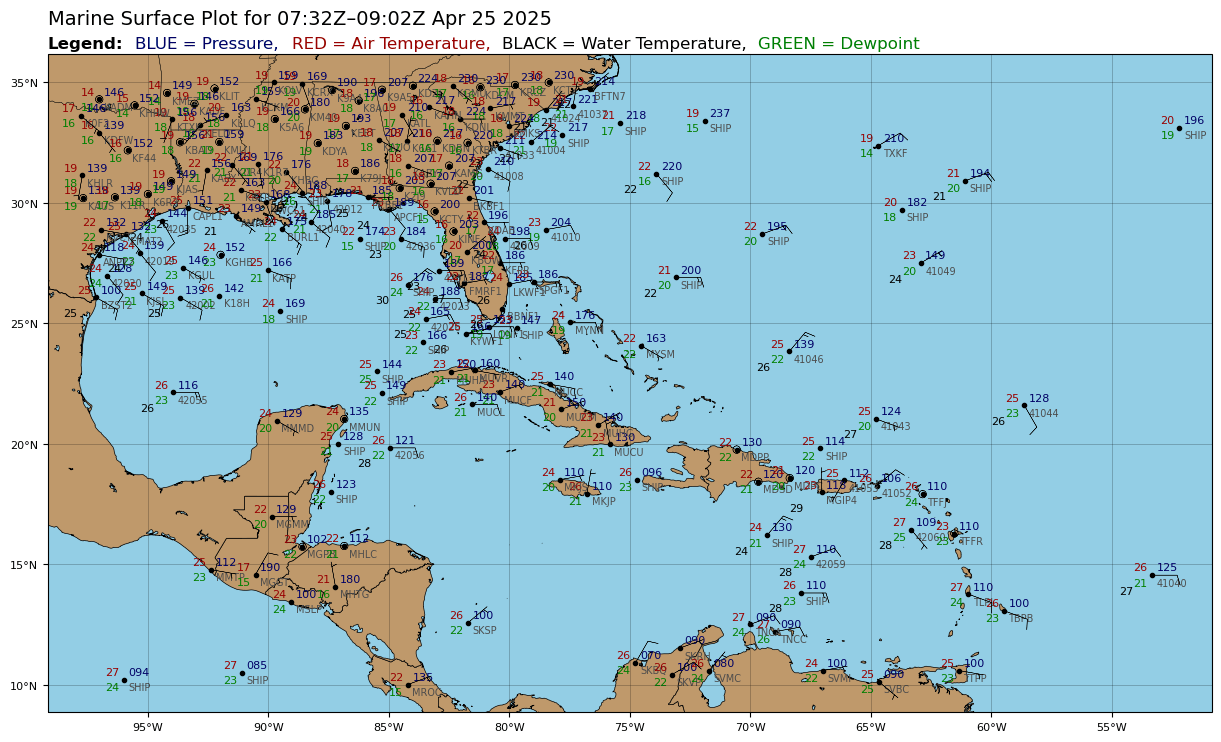
It appears to me that the lowest pressure at the surface is just at the N coast of Hisp., but the actual center of the broader system may be over central Hisp. Note I don't see any stations there in the mountains so we won't know and recon wont do dropsondes there either. The low level cloud motion does not conflict with this. I checked the CIMMS vort map as well so that may be the case. We shall see as this moves offshore, and recon gets more data on the south side.
https://www.tropicaltidbits.com/analysis/sfcplots/sfcplot_latest.png
1 likes
-
cycloneye
- Admin
- Posts: 149712
- Age: 69
- Joined: Thu Oct 10, 2002 10:54 am
- Location: San Juan, Puerto Rico
Re: NATL: INVEST 94L - Discussion (70/90)
0 likes
Visit the Caribbean-Central America Weather Thread where you can find at first post web cams,radars
and observations from Caribbean basin members Click Here
and observations from Caribbean basin members Click Here
-
cycloneye
- Admin
- Posts: 149712
- Age: 69
- Joined: Thu Oct 10, 2002 10:54 am
- Location: San Juan, Puerto Rico
Re: NATL: INVEST 94L - Discussion (70/90)
Puerto Rico got between 1-5 inches of rain from wave 94L.

3 likes
Visit the Caribbean-Central America Weather Thread where you can find at first post web cams,radars
and observations from Caribbean basin members Click Here
and observations from Caribbean basin members Click Here


Re: NATL: INVEST 94L - Discussion (70/90)
Looking more and more like an "interesting" setup for the Charleston area. Last hurricane landfall in the Lowcountry was Ian 2022 (its third landfall, as a Category 1 near Georgetown) iirc. The track guidance spread is still fairly wide & I'll leave making explicit predictions to the professionals, but the local NWS office has started mentioning Invest 94L on their outlooks, which is generally my cue to start taking the prospect of local tropical impacts more seriously.
4 likes

Re: NATL: INVEST 94L - Discussion (70/90)
cycloneye wrote:Blown Away wrote:[url]https://i.postimg.cc/hvwmYmSr/goes19-vis-swir-94-L-202509251257.gif [/url]12z 20.0N / 70.7W
Do we think that naked broad swirl is the circulation moving @WNW from @20.0N / 70.7W??
We will find out the exact position when recon goes this afternoon.
My guess would place a broad LLC at about 20.5 N & 70.7 W, so basically about a 1/2 degree north of Best Track. On the otherhand if no lower pressures existed anywhere near that point then a LLC developing south of the "Rock" is certainly plausible. Models certainly don't reflect that nor is there any evidence of that thus far based on visible satellite. Its hard to ignore the impressive convection south of the Island though.
0 likes
Andy D
(For official information, please refer to the NHC and NWS products.)
(For official information, please refer to the NHC and NWS products.)
-
cycloneye
- Admin
- Posts: 149712
- Age: 69
- Joined: Thu Oct 10, 2002 10:54 am
- Location: San Juan, Puerto Rico
Re: NATL: INVEST 94L - Discussion (70/90)
0 likes
Visit the Caribbean-Central America Weather Thread where you can find at first post web cams,radars
and observations from Caribbean basin members Click Here
and observations from Caribbean basin members Click Here
-
cycloneye
- Admin
- Posts: 149712
- Age: 69
- Joined: Thu Oct 10, 2002 10:54 am
- Location: San Juan, Puerto Rico
Re: NATL: INVEST 94L - Discussion (70/90)
No Air Force recon today but tommorow afternoon it will be flying. To see the complete TCPOD, go to the 94L recon thread
A. THE TEAL 75 AND TEAL 76 MISSIONS INTO AL94 TASKED IN TCPOD
25-116 WERE CANCELED BY NHC AT 25/1200Z.
B. THE TEAL 74 MISSION INTO AL94 HAS BEEN CHANGED TO A LOW-LEVEL INVEST NEAR 21.9N 74.2W FOR 26/1730Z, WITH THE
TAKEOFF TIME CHANGED 6 HOURS TO 26/1545Z
25-116 WERE CANCELED BY NHC AT 25/1200Z.
B. THE TEAL 74 MISSION INTO AL94 HAS BEEN CHANGED TO A LOW-LEVEL INVEST NEAR 21.9N 74.2W FOR 26/1730Z, WITH THE
TAKEOFF TIME CHANGED 6 HOURS TO 26/1545Z
1 likes
Visit the Caribbean-Central America Weather Thread where you can find at first post web cams,radars
and observations from Caribbean basin members Click Here
and observations from Caribbean basin members Click Here
NATL: INVEST 94L - Models
It seems like the only thing potentially holding future Imelda back is the uncertain interactions with Humberto.
0 likes
-
cycloneye
- Admin
- Posts: 149712
- Age: 69
- Joined: Thu Oct 10, 2002 10:54 am
- Location: San Juan, Puerto Rico
Re: NATL: INVEST 94L - Discussion (80/90)
Tropical Weather Outlook
NWS National Hurricane Center Miami FL
200 PM EDT Thu Sep 25 2025
For the North Atlantic...Caribbean Sea and the Gulf of America:
Active Systems:
The National Hurricane Center is issuing advisories on Hurricane
Gabrielle, located several hundred miles west of the Azores, and on
Tropical Storm Humberto, over the subtropical central Atlantic.
Central Caribbean Sea and Southwestern Atlantic (AL94):
Showers and thunderstorms are increasing in association with a
a tropical wave located near Hispaniola and the Turks and Caicos
Islands. An area of low pressure is expected to form along the
wave tonight or early Friday when it moves near the southeast
Bahamas. This low is expected to become a tropical depression when
it is in the vicinity of the central and northwest Bahamas late
Friday or over the weekend and then track northwestward or
northward over the southwestern Atlantic.
Interests in the Dominican Republic, Haiti, the Turks and Caicos
Islands, and the Bahamas should monitor the progress of this
system. Regardless of development, heavy rains and gusty winds
are likely across that region during the next couple of days.
While there is significant uncertainty in the long-range track and
intensity of the system, the chances of wind, rainfall, and storm
surge impacts for a portion of the southeast U.S. coast are
increasing. Interests in that area should monitor the progress of
the system.
* Formation chance through 48 hours...high...80 percent.
* Formation chance through 7 days...high...90 percent.
1 likes
Visit the Caribbean-Central America Weather Thread where you can find at first post web cams,radars
and observations from Caribbean basin members Click Here
and observations from Caribbean basin members Click Here
Re: NATL: INVEST 94L - Models
Fancy1002 wrote:It seems like the only thing potentially holding future Imelda back is the uncertain interactions with Humberto.
The trough in the SE will also be injecting dry air into the system.
0 likes
Who is online
Users browsing this forum: No registered users and 56 guests