SE TX/SW LA Discussion Thread - Heavy Rainfall Threat
Moderator: S2k Moderators
Forum rules

The posts in this forum are NOT official forecast and should not be used as such. They are just the opinion of the poster and may or may not be backed by sound meteorological data. They are NOT endorsed by any professional institution or STORM2K.
-
MississippiHurricane

- ChatStaff

- Posts: 648
- Age: 41
- Joined: Sat Jul 16, 2005 12:20 am
- Location: Hanover, Maryland
- Contact:
-
vbhoutex

- Storm2k Executive

- Posts: 29149
- Age: 74
- Joined: Wed Oct 09, 2002 11:31 pm
- Location: Cypress, TX
- Contact:
Category 5 wrote:TORNADO WARNING NOW INCLUDES METRO HOUSTON!
Luckily it appears it will miss to the north.
SEVERE WEATHER STATEMENT
NATIONAL WEATHER SERVICE HOUSTON/GALVESTON TX
535 PM CDT THU MAY 3 2007
TXC201-291-339-032315-
/O.CON.KHGX.TO.W.0012.000000T0000Z-070503T2315Z/
MONTGOMERY TX-LIBERTY TX-HARRIS TX-
535 PM CDT THU MAY 3 2007
...A TORNADO WARNING CONTINUES FOR EXTREME NORTHEAST
HARRIS...LIBERTY AND EASTERN MONTGOMERY COUNTIES UNTIL 615 PM CDT...
AT 532 PM CDT...NATIONAL WEATHER SERVICE DOPPLER RADAR INDICATED A
LARGE SEVERE THUNDERSTORM CAPABLE OF PRODUCING A TORNADO OVER
EASTERN MONTGOMERY COUNTY...MOVING EAST AT 25 MPH. RADAR SIGNATURE
SUGGESTS A STRONG TORNADO IN THE NEW CANEY AREA. IN ADDITION...HAIL
OF GOLFBALL SIZE OR LARGER AND DAMAGING WINDS ARE LIKELY WITH THIS
STORM. PLEASE SEEK SHELTER IMMEDIATELY!!!
* LOCATIONS IMPACTED INCLUDE...
ROMAN FOREST...
PATTON VILLAGE...
SPLENDORA...
WOODBRANCH...
NEW CANEY...
US HIGHWAY 59...
KINGWOOD...
CLEVELAND...
PLUM GROVE...
PLEASE REPORT SEVERE WEATHER TO THE COUNTY SHERIFF...LOCAL
POLICE...OR DEPARTMENT OF PUBLIC SAFETY. THEY WILL RELAY YOUR REPORT
TO THE NATIONAL WEATHER SERVICE.
LAT...LON 3026 9535 3011 9538 3004 9517 3006 9486
3046 9485
$$
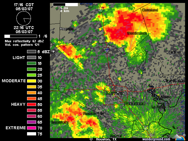
A misconception on your part(missing to the north). Houston is huge and spread out. Yes it was in less densely populated area of the metro area.
It apparently was a tornado-ergo the huge hook echo-NWS is going to evaluate this afternoon. Numerous funnel clouds reported by law enforcement in the area at that time also. This was in the northeastern suburbs of Houston. Numerous trees down including some into homes and one injury due to entrapment.
0 likes
-
JenBayles

- Category 5

- Posts: 3461
- Age: 63
- Joined: Tue Aug 26, 2003 3:27 pm
- Location: Houston, TX
- Contact:
It's 81 now, I wonder if we'll get enough sun today to pop some storms? Right now, not looking like it'll happen...
PREV DISCUSSION... /ISSUED 1026 AM CDT FRI MAY 4 2007/
FORECAST SOUNDINGS OVER THE CENTRAL PART OF THE CWA STILL SHOW
PW`S BETWEEN 1.4 AND 1.6 INCHES THIS AFTERNOON. CONVECTIVE TEMPS
ARE IN THE MIDDLE 80S AND THESE VALUES APPEAR TO BE IN REACH.
SLIGHTLY DRIER AIR IS EVIDENT ABOVE 800 MB BUT THE THERMAL PROFILE
DOES NOT SHOW MUCH IN THE WAY OF CAPPING. FEEL CURRENT FORECAST
HAS A GOOD HANDLE ON THINGS FOR NOW...BUT PRECIPITATION INITIATION
IS STRONGLY DEPENDENT ON THE CLOUDS THINNING AND TEMPS WARMING.
CAPES AND LIS ARE RATHER ROBUST AND IF STORMS BEGIN TO
DEVELOP...WILL NEED TO WATCH FOR SOME PULSE SEVERE. SHEAR IS
CONSIDERABLY LESS THAN YESTERDAY SO WIDESPREAD SEVERE NOT
EXPECTED. 43
0 likes

I just saw this while looking over the convective outlook. It looks like we might have some severe in the next couple of days.
http://www.spc.noaa.gov/products/outlook/day3otlk.html
http://www.spc.noaa.gov/products/outlook/day3otlk.html
0 likes
-
Extremeweatherguy

- Category 5
- Posts: 11095
- Joined: Mon Oct 10, 2005 8:13 pm
- Location: Florida
Yeah, it looks like Thursday through Saturday could get interesting (probably peaking on Friday).Johnny wrote:I just saw this while looking over the convective outlook. It looks like we might have some severe in the next couple of days.
http://www.spc.noaa.gov/products/outlook/day3otlk.html
0 likes

-
jasons2k

- Storm2k Executive
- Posts: 8290
- Age: 52
- Joined: Wed Jul 06, 2005 12:32 pm
- Location: The Woodlands, TX
Oh my gosh!!!
Did anyone else see Fox 26 tonight and John dawson's "explanation" of a subtropical storm vs a tropical storm?? I've never seen a "scientific" story full of so much misinformation. He even said it would take a "more compact system to produce a bigger storm surge". On top of that, he never once even explained the difference between the two.
Did anyone else see Fox 26 tonight and John dawson's "explanation" of a subtropical storm vs a tropical storm?? I've never seen a "scientific" story full of so much misinformation. He even said it would take a "more compact system to produce a bigger storm surge". On top of that, he never once even explained the difference between the two.
0 likes
-
Extremeweatherguy
- Category 5
- Posts: 11095
- Joined: Mon Oct 10, 2005 8:13 pm
- Location: Florida
I missed it, but based on some of the stuff I have seen come from the mets on Fox 26 in the past (except perhaps Cecilia Sinclair) I can believe it. Fox 26 mets do not seem too bright.jschlitz wrote:Oh my gosh!!!
Did anyone else see Fox 26 tonight and John dawson's "explanation" of a subtropical storm vs a tropical storm?? I've never seen a "scientific" story full of so much misinformation. He even said it would take a "more compact system to produce a bigger storm surge". On top of that, he never once even explained the difference between the two.
As a sidenote: Does Cecilia Sinclair still even work there anymore? I havn't seen her give the forecast in a long time.
0 likes
-
jasons2k
- Storm2k Executive
- Posts: 8290
- Age: 52
- Joined: Wed Jul 06, 2005 12:32 pm
- Location: The Woodlands, TX
Here is my email to Fox 26:
I was very surprised at some of the misinformation in John Dawson's subtropical vs. tropical storm segment that aired on 4/9/07. First of all, he never actually explained the difference between the two other than to note a sub is usually larger (by the way, this isn't even an official criteria). Then he goes on to say a "more compact system is needed to produce a storm surge" when in fact, it is the exact opposite. All one needs to do is compare Katrina to Charley.
To air this kind of misinformation is a dangerous disservice to the general public, especially to a hurricane-prone region such as Houston-Galveston.
I'm sure plenty of Emergency Mgt. workers cringed when they saw this.
I only took a few met. classes in college and I know I could have done much better than that...
0 likes
jschlitz wrote:Here is my email to Fox 26:
I was very surprised at some of the misinformation in John Dawson's subtropical vs. tropical storm segment that aired on 4/9/07. First of all, he never actually explained the difference between the two other than to note a sub is usually larger (by the way, this isn't even an official criteria). Then he goes on to say a "more compact system is needed to produce a storm surge" when in fact, it is the exact opposite. All one needs to do is compare Katrina to Charley.
To air this kind of misinformation is a dangerous disservice to the general public, especially to a hurricane-prone region such as Houston-Galveston.
I'm sure plenty of Emergency Mgt. workers cringed when they saw this.
I only took a few met. classes in college and I know I could have done much better than that...
He got that wrong for sure. I never took any Meteorology classes, yet I know the differences. A compact system would produce smaller storm surge.
0 likes
-
Extremeweatherguy
- Category 5
- Posts: 11095
- Joined: Mon Oct 10, 2005 8:13 pm
- Location: Florida
-
jasons2k
- Storm2k Executive
- Posts: 8290
- Age: 52
- Joined: Wed Jul 06, 2005 12:32 pm
- Location: The Woodlands, TX
My wife said I provided "misinformation" by getting the month wrong in my email - oh well... 
Hey EWG - I thought she switched to days for family reasons, but I do see they have an opening on their website. I really wonder sometimes how/why a market as big as Houston can have such inexperienced mets.
Hey EWG - I thought she switched to days for family reasons, but I do see they have an opening on their website. I really wonder sometimes how/why a market as big as Houston can have such inexperienced mets.
0 likes
-
Yankeegirl

- Category 5
- Posts: 3417
- Age: 50
- Joined: Sun May 23, 2004 11:59 pm
- Location: Cy-Fair, Northwest Houston
- Contact:
-
southerngale

- Retired Staff

- Posts: 27418
- Joined: Thu Oct 10, 2002 1:27 am
- Location: Southeast Texas (Beaumont area)
Johnny wrote:It looks like we have a 50% chance of thunderstorm this afternoon and a 60% chance tonight. I haven't seen a weather update from Jeff concerning the rain chances so I'm guessing it won't be that big of a deal?
Only 20%/20% for us. hmmm... usually not such a huge difference between Houston and Beaumont.
0 likes
-
jasons2k
- Storm2k Executive
- Posts: 8290
- Age: 52
- Joined: Wed Jul 06, 2005 12:32 pm
- Location: The Woodlands, TX
Johnny wrote:It looks like we have a 50% chance of thunderstorm this afternoon and a 60% chance tonight. I haven't seen a weather update from Jeff concerning the rain chances so I'm guessing it won't be that big of a deal?
It could be...the pops were raised from 30/40 to 50/60. The air will be plenty unstable with the upper low approaching & divergence and heating, but factors working against us are lack of moisture and shear. Maybe some pulse-type severe storms but not a widesrpead outbreak.
0 likes

Return to “USA & Caribbean Weather”
Who is online
Users browsing this forum: opticsguy and 164 guests