ATL: SANDY - Remnants - Discussion
Moderator: S2k Moderators

-
Weatherguy173

- Tropical Storm

- Posts: 148
- Age: 32
- Joined: Wed Aug 01, 2012 10:55 pm
- Location: Short Hills NJ
Re: ATL: SANDY - Hurricane - Discussion
Bizzles wrote:cycloneye wrote:11 AM advisory forecast track. Look at that left hook at the end.
Aimed right at my house
Two TS Events in two years? Who moved NJ down to the GoM?
same, NJ, makes no sense that this could happen two times in as many years.
0 likes
Nothing I say is intended to be a forecast; it's only food for thought and friendly advice!

Re:
HURAKAN wrote:Reports from Cuban radio indicates that the damage in Santiago de Cuba is as bad as feared, collapsed buildings and others about to fail, no electricity, trees down, etc. I think my name is as good as retired
Oh - that is so sad to hear. I hope that against odds there is no loss of life and few injuries.
0 likes

Re:
HURAKAN wrote:Reports from Cuban radio indicates that the damage in Santiago de Cuba is as bad as feared, collapsed buildings and others about to fail, no electricity, trees down, etc. I think my name is as good as retired
So sorry to hear that. My thoughts and prayers go out to them.
0 likes
-
ozonepete
- Professional-Met

- Posts: 4743
- Joined: Mon Sep 07, 2009 3:23 pm
- Location: From Ozone Park, NYC / Now in Brooklyn, NY
Re:
HURAKAN wrote:Reports from Cuban radio indicates that the damage in Santiago de Cuba is as bad as feared, collapsed buildings and others about to fail, no electricity, trees down, etc. I think my name is as good as retired
So sorry to hear that Sandy. Those poor people.
I'm quite sure Sandy will be retired from that alone, but additionally we have some really bad signs for the northeast U.S. now as well. This is shaping up as an historic hurricane.
0 likes

-
Blown Away

- S2K Supporter

- Posts: 10253
- Joined: Wed May 26, 2004 6:17 am
Re: ATL: SANDY - Hurricane - Discussion
Sandy is flying and continues to be right of the NHC track, I wonder if this slow down/NW jog is gonna happen east of Florida or just a slow right adjustment of the NHC track over the next 48 hours.
0 likes
Hurricane Eye Experience: David 79, Irene 99, Frances 04, Jeanne 04, Wilma 05… Hurricane Brush Experience: Andrew 92, Erin 95, Floyd 99, Matthew 16, Irma 17, Ian 22, Nicole 22…

-
ozonepete
- Professional-Met
- Posts: 4743
- Joined: Mon Sep 07, 2009 3:23 pm
- Location: From Ozone Park, NYC / Now in Brooklyn, NY
Re: ATL: SANDY - Hurricane - Discussion
Bizzles wrote:cycloneye wrote:11 AM advisory forecast track. Look at that left hook at the end.
http://oi46.tinypic.com/2rmw8ih.jpg
Aimed right at my house
Two TS Events in two years? Who moved NJ down to the GoM?
Wow, this is not good news for us at all in the northeast.
0 likes

By the time this system gets close to the latitude of New York there probably won't be much of an inner core left, it'll be a large spread out system and the main risks will be both flooding and wind GUSTS...I'm not sure sustained winds will be super high unless it somehow keeps its tropical identity going, which given its forward speed it'll struggle to do (though the models do indicate it'll likely still have some tropical aspects if nothing else.)
0 likes
Personal Forecast Disclaimer:
The posts in this forum are NOT official forecast and should not be used as such. They are just the opinion of the poster and may or may not be backed by sound meteorological data. They are NOT endorsed by any professional institution or storm2k.org. For official information, please refer to the NHC and NWS products
The posts in this forum are NOT official forecast and should not be used as such. They are just the opinion of the poster and may or may not be backed by sound meteorological data. They are NOT endorsed by any professional institution or storm2k.org. For official information, please refer to the NHC and NWS products


Re: ATL: SANDY - Hurricane - Discussion
ozonepete wrote:Bizzles wrote:cycloneye wrote:11 AM advisory forecast track. Look at that left hook at the end.
http://oi46.tinypic.com/2rmw8ih.jpg
Aimed right at my house
Two TS Events in two years? Who moved NJ down to the GoM?
Wow, this is not good news for us at all in the northeast.
No not good news at all. The hype should begin soon. Once the media runs with it..people with be either panicked or complacent.
0 likes
-
Bocadude85

- Category 5

- Posts: 2991
- Age: 39
- Joined: Mon Apr 18, 2005 2:20 pm
- Location: Honolulu,Hi
Re: ATL: SANDY - Hurricane - Discussion
Looks like they shifted the track a touch west near the northern bahamas. At the 5am advisory she wasnt forecast to go west of 76.6w and the 11am advisory has her making it to 76.9w....not huge but still a westward adjustment.
0 likes
-
ozonepete
- Professional-Met
- Posts: 4743
- Joined: Mon Sep 07, 2009 3:23 pm
- Location: From Ozone Park, NYC / Now in Brooklyn, NY
Re:
Frank2 wrote:Yes, the Cuban landall at that strength was not expected - as the pro mets have said, it was possibly a Cat 3 at the time...
P.S. Ozonepete, not to undo your title but I'm guessing that this will not happen and will remain offshore - if it were August that'd be another issue but not now...
What's your guess based on?
0 likes
-
brunota2003

- S2K Supporter
- Posts: 9476
- Age: 35
- Joined: Sat Jul 30, 2005 9:56 pm
- Location: Stanton, KY...formerly Havelock, NC
- Contact:
-
Weatherboy1

- Category 5
- Posts: 1190
- Age: 50
- Joined: Mon Jul 05, 2004 1:50 pm
- Location: Jupiter/Sarasota, FL
Cloud pattern really seems to be flattening out east-to-west. Typically these kinds of things happen before a track shift (in other words, the outflow cloud shield "points" where the storm is going to go). I wouldn't be surprised to see the slowdown and turn to materialize very soon. Only question is how close it gets to the FL east coast, in my opinion.
0 likes
-
ozonepete
- Professional-Met
- Posts: 4743
- Joined: Mon Sep 07, 2009 3:23 pm
- Location: From Ozone Park, NYC / Now in Brooklyn, NY
Re: ATL: SANDY - Hurricane - Discussion
Getting that dreaded very circular shape again that it got before bombing out last night. The closer to a perfect circle the core gets the faster the pressure will drop at the center and the higher the winds will get.

0 likes
-
tolakram
- Admin

- Posts: 20186
- Age: 62
- Joined: Sun Aug 27, 2006 8:23 pm
- Location: Florence, KY (name is Mark)
Re: ATL: SANDY - Hurricane - Discussion
Live loop, zoom 2, speed up for full effect: http://wwwghcc.msfc.nasa.gov/cgi-bin/ge ... mframes=15
Appears, if that's the center that is visible, that north or slightly NW movement has begun. Next recon pass will tell the story.

Appears, if that's the center that is visible, that north or slightly NW movement has begun. Next recon pass will tell the story.
0 likes
M a r k
- - - - -
Join us in chat: Storm2K Chatroom Invite. Android and IOS apps also available.
The posts in this forum are NOT official forecasts and should not be used as such. Posts are NOT endorsed by any professional institution or STORM2K.org. For official information and forecasts, please refer to NHC and NWS products.
-
Blown Away
- S2K Supporter
- Posts: 10253
- Joined: Wed May 26, 2004 6:17 am
Re: ATL: SANDY - Hurricane - Discussion
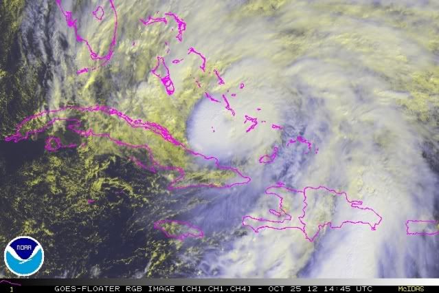
tolakram wrote:Live loop, zoom 2, speed up for full effect: http://wwwghcc.msfc.nasa.gov/cgi-bin/ge ... mframes=15
Appears, if that's the center that is visible, that north or slightly NW movement has begun. Next recon pass will tell the story.
[img]http://imageshack.us/a/img42/5843/zzsandy.jpg[/ig]
I agree, it appears to be an abrupt NW jog. Amazing, I love these late season storms and their, at times, crazy tracks.
http://www.ssd.noaa.gov/PS/TROP/floater ... -long.html
0 likes
Hurricane Eye Experience: David 79, Irene 99, Frances 04, Jeanne 04, Wilma 05… Hurricane Brush Experience: Andrew 92, Erin 95, Floyd 99, Matthew 16, Irma 17, Ian 22, Nicole 22…
Who is online
Users browsing this forum: No registered users and 64 guests