12z Fim Model
http://fim.noaa.gov/FIMscp/jsloop.cgi?d ... 244&wjet=1
ATL: ISAAC - Models
Moderator: S2k Moderators
-
stormandan28
- Tropical Storm

- Posts: 108
- Joined: Mon Jun 14, 2004 11:13 am
- Contact:
-
SunnyThoughts
- Category 5

- Posts: 2263
- Joined: Wed Jul 09, 2003 12:42 pm
- Location: Pensacola, Florida
Re: ATL: NINE - Models
Last edited by tolakram on Tue Aug 21, 2012 3:49 pm, edited 1 time in total.
Reason: removed direct embed of image
Reason: removed direct embed of image
0 likes

Euro is the best model
Weatherfreak000 wrote:Wow....I thought I saw a west shift beginning. Here we go!!
Yep, when the 00z Euro came out I wondered if King Euro was setting the west trend and now with the 2nd run showing even more pronounced west movement, it only needs one more run of the same to confirm it for me. This outcome for the latest is exactly what I thought it would show if it continued.
The Euro run was extremely interesting, weak up until the Yucatan peninsula and then bombs in the Gulf. Its 1 mb lower than the last run (961 mb - maybe category 3) at 240 hours and takes an Ivan or Dennis path. I only consider after 240 hours for the Euro fantasy land as I believe there is still a tiny amount of skill during that long range. With that said, I would love to know for any mets that have the ultra-long range Euro available, where does it make landfall and how strong?
ROCK wrote:really warm..28C- 29C probably even some 30Cs somewhere in there....
Not just some 30ºC points, most of it is that I think with the surrounding areas around the former stated.
0 likes
-
OuterBanker
- S2K Supporter

- Posts: 1761
- Joined: Wed Feb 26, 2003 10:53 am
- Location: Nags Head, NC
- Contact:
-
weatherwindow

- Category 4

- Posts: 904
- Joined: Mon Sep 20, 2004 9:48 am
- Location: key west/ft lauderdale
Re:
Weatherboy1 wrote:FWIW, HPC day 6-7 positions for TD9 are just off the SW coast of FL heading generally NW to NNW. A more gradual turn in general being forecasted, but as several people have noted (myself included!) we are still 6-ish days out on this thing. Could be an Ivan, could be a Cleo, or could be something else entirely! Really too early to say!
http://www.hpc.ncep.noaa.gov/medr/nav_c ... fcolor=ter
FYI..Unfortunately the HPC tropical positions are not independently generated. They conference with TPC/NHC and the NHC inhouse extended forecast positions are proxied into the HPC products. Therefore, dont put any special weight on those numbers except that they reflect current NHC thinking in the extended realm and will change or not as their forecast thinking evolves....Rich
Last edited by weatherwindow on Tue Aug 21, 2012 3:17 pm, edited 1 time in total.
0 likes
-
Weatherboy1

- Category 5
- Posts: 1190
- Age: 50
- Joined: Mon Jul 05, 2004 1:50 pm
- Location: Jupiter/Sarasota, FL
My only thought with the euro is that is probably UNDERestimating TD9's strength, and therefore seeing it move farther west ... just like the CMC is likely OVERestimating the speed at which TD9 will strengthn, and therefore predicting a much earlier hook to the north. I like a solution more in between at this time, though if the models ALL shift signficantly westward overnight, I will reconsider.
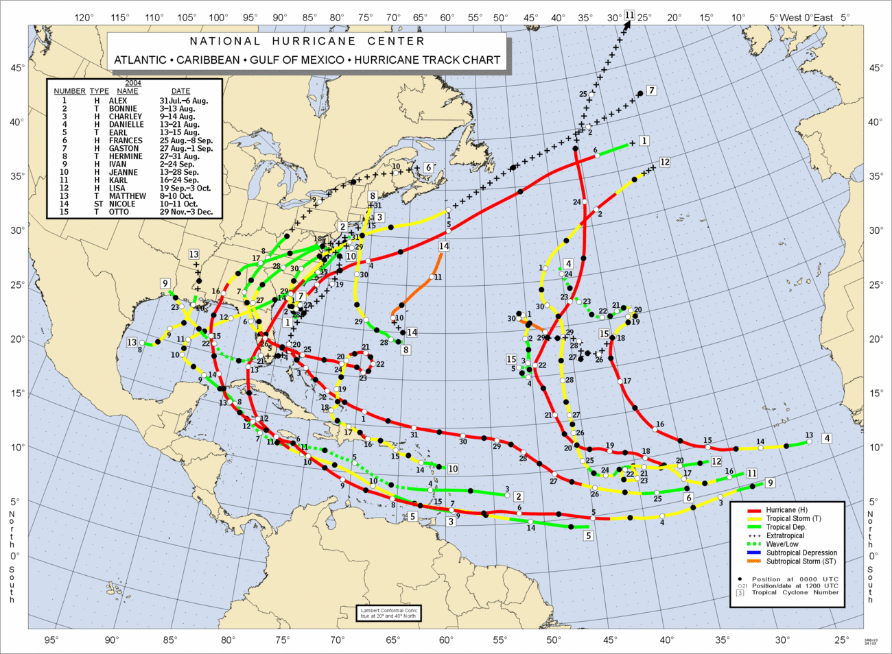
The one problem I have with an Ivan-like (2004) scenario is that he was much farther south in the eastern Caribbean. As you can see here, he was running along the 12-13N line before he began his gradual turn to the WNW then NW. That's one reason I think the models failed back then when they forecast a sharp turn and run up the spine of Florida. TD9 is along 15N already and isn't even in the Caribbean yet. So I think the chance of feeling any weakness earlier is higher.
http://www.nhc.noaa.gov/tracks/2004atl.gif
Just my opinion ... no I am not a pro ... as always!
0 likes
Re: ATL: NINE - Models
MEH..........
EXTENDED FORECAST DISCUSSION
NWS HYDROMETEOROLOGICAL PREDICTION CENTER COLLEGE PARK MD
215 PM EDT TUE AUG 21 2012
VALID 12Z FRI AUG 24 2012 - 12Z TUE AUG 28 2012
PRELIMINARY UPDATE...
USED THE 00Z/21 ECENS MEAN TO UPDATE THE PRELIMINARY FRONTS AND
PRESSURES FOR DAYS 3 THROUGH 7. THE ECENS MEAN SHARED MORE IN
COMMON WITH THE VARIOUS GLOBAL DETERMINISTIC MODELS THAN THE GEFS
MEAN...THE SAID DETERMINISTIC GUIDANCE SHOWING ENOUGH SPREAD
THROUGH THE PERIOD TO NOT TRUST THEIR DETAILS. EXTRAPOLATED THE
09Z/21 NATIONAL HURRICANE CENTER FORECAST FOR THE DEPICTION OF
TROPICAL DEPRESSION NINE...WHICH WOULD TAKE THE SYSTEM TOWARD THE
FLORIDA PENINSULA DAYS 6 AND 7. WILL REFINE THE TRACK OF THIS
POTENTIAL HURRICANE DURING THE MIDDAY COORDINATION CALL.
FINAL...
SAW NO COMPELLING REASONS IN THE 12Z/21 MODEL CYCLE TO STRAY FROM
THE UPDATE PACKAGE FOR THE FINAL ISSUANCE. THERE IS STILL A GREAT
DEAL OF SPREAD WITH THE ULTIMATE TRACK OF TROPICAL DEPRESSION
NINE. THE SLIGHT ADJUSTMENT IN THE DAYS 6 AND 7 LOW PLACEMENT WAS
THE RESULT OF THE COORDINATION WITH THE NATIONAL HURRICANE CENTER.
0 likes
-
weatherwindow
- Category 4
- Posts: 904
- Joined: Mon Sep 20, 2004 9:48 am
- Location: key west/ft lauderdale
Re: ATL: NINE - Models
SunnyThoughts wrote:http://www.texasstormchasers.com/wp-content/uploads/2012/08/aal09_2012082112_track_gfs.png
Do you think this might suggest a Florida landfall....LOL...I doubt that I have ever seen Florida so completely bracketed in 18 years..Rich
0 likes
-
HURRICANELONNY
- Category 5
- Posts: 1390
- Joined: Wed May 07, 2003 6:48 am
- Location: HOLLYWOOD.FL
Re: ATL: NINE - Models
The models will change as recon gets more data in the coming days. I'm not to worried. I'll keep an eye on possible Isaac. I've seen way too many model changes in the past years. But you are right. That is one heck of a consesus. Also I've seen storms that were suppose to turn into a Hurricane disapate over the island mountains. That's why I'll just keep one eye on it for now. 
0 likes
hurricanelonny
-
Bocadude85

- Category 5
- Posts: 2991
- Age: 39
- Joined: Mon Apr 18, 2005 2:20 pm
- Location: Honolulu,Hi
Re: ATL: NINE - Models
SFLcane wrote:Another view of the 18z plots for Issac..
http://derecho.math.uwm.edu/models/al092012.png
Im still confused on what exactly the OFCI plot is... if it is the NHC official track then why does it go out further then their current 5 day track?
0 likes
Re: ATL: NINE - Models
HURRICANELONNY wrote:The models will change as recon gets more data in the coming days. I'm not to worried. I'll keep an eye on possible Isaac. I've seen way too many model changes in the past years. But you are right. That is one heck of a consesus. Also I've seen storms that were suppose to turn into a Hurricane disapate over the island mountains. That's why I'll just keep one eye on it for now.
Not only will the models change, but interaction with the mountains of Haiti/DR and eastern Cuba could really change things up.. ala Debby 2001 and Ernesto 2006.. we shall see.
The posts in this forum are NOT official forecast and should not be used as such. They are just the opinion of the poster and may or may not be backed by sound meteorological data. They are NOT endorsed by any professional institution or storm2k.org. For official information, please refer to the NHC and NWS products
0 likes
-
BigB0882
- S2K Supporter
- Posts: 2291
- Joined: Thu Jul 03, 2003 12:08 am
- Location: Baton Rouge, LA
- Contact:
I am barely knowledgable enough to even call myself a novice so please correct me if I am wrong but in the 240 hour map for the Euro is the ridge building in really strong? Might this possibly block any NE movement or even possibly continue pushing it more NW or NNW? Or can a hurricane of that strength push right on through? Or perhaps I just don't know how to read those darn maps. lol
0 likes
-
Stormcenter
- S2K Supporter
- Posts: 6689
- Joined: Wed Sep 03, 2003 11:27 am
- Location: Houston, TX
-
SouthFLTropics

- Category 5
- Posts: 4258
- Age: 50
- Joined: Thu Aug 14, 2003 8:04 am
- Location: Port St. Lucie, Florida
Re: ATL: NINE - Models
45 minutes till the 18z GFS...I can hardly wait to see where it takes us. Place your bets now. Does the GFS hold serve or does it follow the EURO???
SFT
SFT
0 likes
Fourth Generation Florida Native
Personal Storm History: David 79, Andrew 92, Erin 95, Floyd 99, Irene 99, Frances 04, Jeanne 04, Wilma 05, Matthew 16, Irma 17, Ian 22, Nicole 22, Milton 24
Personal Storm History: David 79, Andrew 92, Erin 95, Floyd 99, Irene 99, Frances 04, Jeanne 04, Wilma 05, Matthew 16, Irma 17, Ian 22, Nicole 22, Milton 24
-
Bocadude85
- Category 5
- Posts: 2991
- Age: 39
- Joined: Mon Apr 18, 2005 2:20 pm
- Location: Honolulu,Hi
Re: ATL: NINE - Models
SouthFLTropics wrote:45 minutes till the 18z GFS...I can hardly wait to see where it takes us. Place your bets now. Does the GFS hold serve or does it follow the EURO???
SFT
Id be willing to bet it goes a little further west
0 likes
-
Riptide

- Category 2

- Posts: 753
- Age: 34
- Joined: Fri Jul 23, 2010 3:33 pm
- Location: Cape May, New Jersey
- Contact:
Re: ATL: NINE - Models
SouthFLTropics wrote:45 minutes till the 18z GFS...I can hardly wait to see where it takes us. Place your bets now. Does the GFS hold serve or does it follow the EURO???
SFT
Recurve, affecting no one. CMC scores a massive coup.
0 likes
-
SeminoleWind
- Category 1

- Posts: 359
- Age: 51
- Joined: Wed Jun 02, 2010 8:37 pm
- Location: Lake County Florida
I think the GFS will hold its ground, ,,,for now.
TD 9 (Isaac) is slowing down some which may give it a better chance to strengthen some.JMO
TD 9 (Isaac) is slowing down some which may give it a better chance to strengthen some.JMO
0 likes
This post is NOT an official forecast and should not be used as such. It is just the opinion of the poster and may or may not be backed by sound meteorological data. It is NOT endorsed by any professional institution including storm2k.org For Official Information please refer to the NHC and NWS products.
-
jlauderdal
- S2K Supporter
- Posts: 7240
- Joined: Wed May 19, 2004 5:46 am
- Location: NE Fort Lauderdale
- Contact:
Re: ATL: NINE - Models
weatherwindow wrote:SunnyThoughts wrote:http://www.texasstormchasers.com/wp-content/uploads/2012/08/aal09_2012082112_track_gfs.png
Do you think this might suggest a Florida landfall....LOL...I doubt that I have ever seen Florida so completely bracketed in 18 years..Rich
hurricane debby about 10 years ago, had miami in its sites in 48 hours and hit hispanola, full dissipation....hurricane ike a few years ago had miami in its sites at about 72 h, kept going west, west then sw, missed us completely, those are two that come to mind, there have been more
0 likes
-
thetruesms

- Professional-Met

- Posts: 844
- Age: 42
- Joined: Thu Aug 16, 2007 1:14 pm
- Location: Tallahasee, FL
- Contact:
Re: ATL: NINE - Models
NHC is internally testing 7 day forecasts - OFCI is probably reflecting thatBocadude85 wrote:SFLcane wrote:Another view of the 18z plots for Issac..
http://derecho.math.uwm.edu/models/al092012.png
Im still confused on what exactly the OFCI plot is... if it is the NHC official track then why does it go out further then their current 5 day track?
0 likes
-
Wx_Warrior
- Category 5
- Posts: 2718
- Joined: Thu Aug 03, 2006 3:58 pm
- Location: Beaumont, TX
Re: ATL: ISSAC - Models
Isaac, not "Issac"
Would be a major coup if CMC won this war. I never put much stock this far out in 6z/18z gfs.
Would be a major coup if CMC won this war. I never put much stock this far out in 6z/18z gfs.
0 likes
Who is online
Users browsing this forum: No registered users and 22 guests