2016 Global Model Runs Discussion (Out to Day 16)
Moderator: S2k Moderators
Forum rules

The posts in this forum are NOT official forecasts and should not be used as such. They are just the opinion of the poster and may or may not be backed by sound meteorological data. They are NOT endorsed by any professional institution or STORM2K. For official information, please refer to products from the National Hurricane Center and National Weather Service.
-
Blown Away

- S2K Supporter

- Posts: 10253
- Joined: Wed May 26, 2004 6:17 am
Re: 2016 Global Model Runs Discussion (Out to Day 16)
Weak shallow systems is what models have seen in the Atlantic basin year after year... We see GFS/Euro bomb out EPAC systems on a regular basis... Not sure how many years must pass before it becomes a trend... Rarely do we see a well developed Atl system in the model runs... Likely the Atlantic will hit the number mark, but it sure does seem the storm quality has dropped significantly for near a decade... BOC & N Atl have been the breeding grounds... Just a very amateur observation...
1 likes
Hurricane Eye Experience: David 79, Irene 99, Frances 04, Jeanne 04, Wilma 05… Hurricane Brush Experience: Andrew 92, Erin 95, Floyd 99, Matthew 16, Irma 17, Ian 22, Nicole 22…
-
tarheelprogrammer

- S2K Supporter
- Posts: 1793
- Joined: Mon Mar 28, 2016 9:25 pm
- Location: Raleigh, NC area (Garner, NC)
Re: 2016 Global Model Runs Discussion (Out to Day 16)
So far GFS coming in weaker. About to cave to ECMWF and CMC?
0 likes
My posts are not official forecasts. They are just my opinion and may or may not be backed by sound meteorological data. They are NOT endorsed by any professional institution or storm2k.org. For official information, please refer to the NHC and NWS products.
-
TheAustinMan

- Category 5

- Posts: 1060
- Joined: Mon Jul 08, 2013 4:26 pm
- Location: Central TX / United States
Re: 2016 Global Model Runs Discussion (Out to Day 16)
Blown Away wrote:Weak shallow systems is what models have seen in the Atlantic basin year after year... We see GFS/Euro bomb out EPAC systems on a regular basis... Not sure how many years must pass before it becomes a trend... Rarely do we see a well developed Atl system in the model runs...
That's what we should expect. The Atlantic is traditionally the Northern Hemisphere's third most active tropical cyclone basin, behind the Western and Eastern Pacific. Why are model storms of great importance? Better to have an intense storm on the models that has the potential to impact civilization not materialize than materialize. And sure there's been plenty of instances where the models have indicated strong systems in the Atlantic in the past few years - that's where the "phantom storm" fame comes from. I can note Erika last year: it was shown to be quite intense on the models, and how did that turn out? There's also this from the GFS ensembles last mid-October. Sheer number of "strong model hurricanes" should not be a metric by which to judge the activity of a hurricane season. Besides, the majority of tropical cyclones are the weak shallow systems you mention, so if we see a greater proportion of those, that would be accurate and would indicate the models are becoming more realistic and improving with time.
I don't want to be completely off topic though, so here's the mid-level RH on the GFS 00z run for this Cape Verde system out to 192 hours. The "pouch" of moisture associated with the disturbance is trying it's best to fuel the system, and even has the aid of a sort of sacrificial high amplitude wave ahead of it to moisten the region a bit, but doesn't appear to be cohesive enough to keep out the onrush of drier air from the east, at least for now.

0 likes
Treat my opinions with a grain of salt. For official information see your local weather service.
“It's tough to make predictions, especially about the future.”
“It's tough to make predictions, especially about the future.”
-
tarheelprogrammer
- S2K Supporter
- Posts: 1793
- Joined: Mon Mar 28, 2016 9:25 pm
- Location: Raleigh, NC area (Garner, NC)
Re: 2016 Global Model Runs Discussion (Out to Day 16)
GFS says what storm? LMAO completely caved in to the other models. Phantom storm it seems. The Atlantic used to be a place where storms would form but now it takes everything being completely perfect to spit out one good storm. Could the salinity of the water from melting ice be to blame? Hurricanes need salty water right? Dumb question I know. 
0 likes
My posts are not official forecasts. They are just my opinion and may or may not be backed by sound meteorological data. They are NOT endorsed by any professional institution or storm2k.org. For official information, please refer to the NHC and NWS products.


Re: 2016 Global Model Runs Discussion (Out to Day 16)
1) It is July 22. The median Atlantic ACE for this date is 6.8. We have very slightly less ACE than that.
2) Climate change will not make the Atlantic a weaker basin, and ice from the Arctic cannot reach the tropics. Outside of Newfoundland, it melts before reaching 60°N. In wintertime, icebergs from Greenlandic glaciers can sometimes make it into the Gulf Stream, but melt. The only area where these changes will impact salinity are in the far north Atlantic, in an area roughly outlined by Greenland, Iceland, Ireland, and Newfoundland.
3) The fact that the wave is not predicted to develop immediately once it exists the coast of Africa is not a good indicator that the Atlantic as a basin is becoming less active. It is because of dry air, a very typical feature of July in the Atlantic.
0 likes

-
USTropics
- Professional-Met

- Posts: 2738
- Joined: Sun Aug 12, 2007 3:45 am
- Location: Florida State University
Re: 2016 Global Model Runs Discussion (Out to Day 16)
tarheelprogrammer wrote:GFS says what storm? LMAO completely caved in to the other models. Phantom storm it seems. The Atlantic used to be a place where storms would form but now it takes everything being completely perfect to spit out one good storm. Could the salinity of the water from melting ice be to blame? Hurricanes need salty water right? Dumb question I know.
No hurricanes do not need salt water, it's mostly water temperatures that propels them. In fact, less salinity in the water could be more beneficial.
Salty water is going to naturally be more dense then fresh water. In areas of the ocean where excess rainfall or river deltas dump into the ocean, we can see a top layer of fresh water, creating more depth to the thermocline. This is referred to as a barrier layer, and it develops when the psynocline (density transition depth) is shallower than the thermocline.
Essentially, a barrier layer forms when the surface water becomes much less dense than the saltier water below, preventing the two from mixing. This means less upwelling (36% less at times).
There has been some extensive research on this as well. In fact, researchers used observations and high resolution climate model simulations to analyse almost 600 tropical cyclones in the major tropical barrier layer regions — the Western Tropical Pacific, Tropical Northwestern Atlantic, and Northern Indian Ocean tropical basins — from 1998 to 2007.
You can find out more in this PNAS article: http://www.pnas.org/content/109/36/14343.short
Below is the Abstract:
Improving a tropical cyclone’s forecast and mitigating its destructive potential requires knowledge of various environmental factors that influence the cyclone’s path and intensity. Herein, using a combination of observations and model simulations, we systematically demonstrate that tropical cyclone intensification is significantly affected by salinity-induced barrier layers, which are “quasi-permanent” features in the upper tropical oceans. When tropical cyclones pass over regions with barrier layers, the increased stratification and stability within the layer reduce storm-induced vertical mixing and sea surface temperature cooling. This causes an increase in enthalpy flux from the ocean to the atmosphere and, consequently, an intensification of tropical cyclones. On average, the tropical cyclone intensification rate is nearly 50% higher over regions with barrier layers, compared to regions without. Our finding, which underscores the importance of observing not only the upper-ocean thermal structure but also the salinity structure in deep tropical barrier layer regions, may be a key to more skillful predictions of tropical cyclone intensities through improved ocean state estimates and simulations of barrier layer processes. As the hydrological cycle responds to global warming, any associated changes in the barrier layer distribution must be considered in projecting future tropical cyclone activity.
Also one other thing. The melting glaciers will have a global impact on ALL oceans, not just the Atlantic.
1 likes

Re: 2016 Global Model Runs Discussion (Out to Day 16)
Darvince wrote:3) The fact that the wave is not predicted to develop immediately once it exists the coast of Africa is not a good indicator that the Atlantic as a basin is becoming less active. It is because of dry air, a very typical feature of July in the Atlantic.
I agree but it certainly doesn't say much for how good the upgrade was--the lack of phantom storms over the last several weeks had my hopes up that the model would actually be slightly accurate this year.
I will add regarding some of the reduced forecasts: weather watching is 90% patience and waiting.
Regarding the salinity, I've seen numerous reports after 2013 that climate change could be causing a reduction in the thermohaline circulation by injecting too much fresh water in arctic areas, and this reduction could increase salinity in the tropics--the Atlantic could be more effected due to the largest land glacier in the northern Hemisphere being on Greenland.
On the matter of model runs, the Euro indicates waves are going to start making it into the Gulf of Mexico, and even if it shows no development at the moment this is a major change given they've been pushed straight west into the Pacific on a near constant basis over the last six weeks.
1 likes
The above post is not official and should not be used as such. It is the opinion of the poster and may or may not be backed by sound meteorological data. It is not endorsed by any professional institution or storm2k.org. For official information, please refer to the NHC and NWS products.
-
stormwise
Re: 2016 Global Model Runs Discussion (Out to Day 16)
https://i.imgsafe.org/1de89c52ed.png
Ens same storm as the GFS, but a fish cane.
Ens same storm as the GFS, but a fish cane.
0 likes
-
Fego

- S2K Supporter
- Posts: 767
- Age: 66
- Joined: Sun Apr 18, 2004 7:58 pm
- Location: San Juan, Puerto Rico
- Contact:
Re: 2016 Global Model Runs Discussion (Out to Day 16)
stormwise wrote:https://i.imgsafe.org/1de89c52ed.png
Ens same storm as the GFS, but a fish cane.
Good morning. Is that link available? Thanks.
0 likes
Go Giants! Go Niners! Go Warriors!
-
cycloneye

- Admin

- Posts: 149389
- Age: 69
- Joined: Thu Oct 10, 2002 10:54 am
- Location: San Juan, Puerto Rico
Re: 2016 Global Model Runs Discussion (Out to Day 16)
1 likes
Visit the Caribbean-Central America Weather Thread where you can find at first post web cams,radars
and observations from Caribbean basin members Click Here
and observations from Caribbean basin members Click Here
-
euro6208
Re: 2016 Global Model Runs Discussion (Out to Day 16)
Blown Away wrote:Weak shallow systems is what models have seen in the Atlantic basin year after year... We see GFS/Euro bomb out EPAC systems on a regular basis... Not sure how many years must pass before it becomes a trend... Rarely do we see a well developed Atl system in the model runs... Likely the Atlantic will hit the number mark, but it sure does seem the storm quality has dropped significantly for near a decade... BOC & N Atl have been the breeding grounds... Just a very amateur observation...
The Atlantic is like the little sister to the EPAC (Father) and the notorious WPAC (Mother).
0 likes


Re: 2016 Global Model Runs Discussion (Out to Day 16)
euro6208 wrote:Blown Away wrote:Weak shallow systems is what models have seen in the Atlantic basin year after year... We see GFS/Euro bomb out EPAC systems on a regular basis... Not sure how many years must pass before it becomes a trend... Rarely do we see a well developed Atl system in the model runs... Likely the Atlantic will hit the number mark, but it sure does seem the storm quality has dropped significantly for near a decade... BOC & N Atl have been the breeding grounds... Just a very amateur observation...
The Atlantic is like the little sister to the EPAC (Father) and the notorious WPAC (Mother).It's just the way it is.
History tells of all basins having all their unique storms.
0 likes
The posts or stuff said are NOT an official forecast. Please look to the NHC and NWS for official forecasts and products.
Floyd-1999, Frances-2004, Jeanne-2004, Fay-2008, Beryl-2012, Debby-2012, Colin-2016, Hermine-2016, Julia-2016, Matthew-2016, Irma-2017, Elsa-2021, Idalia-2023, Debby-2024, Helene-2024.
Go Gators! Go Jags!
Floyd-1999, Frances-2004, Jeanne-2004, Fay-2008, Beryl-2012, Debby-2012, Colin-2016, Hermine-2016, Julia-2016, Matthew-2016, Irma-2017, Elsa-2021, Idalia-2023, Debby-2024, Helene-2024.
Go Gators! Go Jags!
-
srainhoutx

- S2K Supporter
- Posts: 6919
- Age: 68
- Joined: Sun Jan 14, 2007 11:34 am
- Location: Haywood County, NC
- Contact:
Re: 2016 Global Model Runs Discussion (Out to Day 16)
Conditions in aiding the development of vigorous tropical waves are slowly increasing across Africa and the Indian Ocean as we near the end of July and begin August. The quiet pattern across the Atlantic Basin appears to be near the end of its 6-7 week slumber as the Eastern Pacific shuts down and potential tropical activity in the Atlantic Basin begins.

2 likes
Carla/Alicia/Jerry(In The Eye)/Michelle/Charley/Ivan/Dennis/Katrina/Rita/Wilma/Ike/Harvey
Member: National Weather Association
Wx Infinity Forums
http://wxinfinity.com/index.php
Facebook.com/WeatherInfinity
Twitter @WeatherInfinity
Member: National Weather Association
Wx Infinity Forums
http://wxinfinity.com/index.php
Facebook.com/WeatherInfinity
Twitter @WeatherInfinity
Re: 2016 Global Model Runs Discussion (Out to Day 16)
Newest run from the GFS has a TS in 120 hours/five days. Interesting that the Euro is beginning to sniff out something too.
http://www.tropicaltidbits.com/analysis ... ics_21.png
http://www.tropicaltidbits.com/analysis ... ics_21.png
0 likes
The posts or stuff said are NOT an official forecast. Please look to the NHC and NWS for official forecasts and products.
Floyd-1999, Frances-2004, Jeanne-2004, Fay-2008, Beryl-2012, Debby-2012, Colin-2016, Hermine-2016, Julia-2016, Matthew-2016, Irma-2017, Elsa-2021, Idalia-2023, Debby-2024, Helene-2024.
Go Gators! Go Jags!
Floyd-1999, Frances-2004, Jeanne-2004, Fay-2008, Beryl-2012, Debby-2012, Colin-2016, Hermine-2016, Julia-2016, Matthew-2016, Irma-2017, Elsa-2021, Idalia-2023, Debby-2024, Helene-2024.
Go Gators! Go Jags!

Re: 2016 Global Model Runs Discussion (Out to Day 16)
JaxGator wrote:Newest run from the GFS has a TS in 120 hours/five days. Interesting that the Euro is beginning to sniff out something too.
http://www.tropicaltidbits.com/analysis ... ics_21.png
I'd say the tide's a turning.....
0 likes
Andy D
(For official information, please refer to the NHC and NWS products.)
(For official information, please refer to the NHC and NWS products.)
-
cycloneye
- Admin
- Posts: 149389
- Age: 69
- Joined: Thu Oct 10, 2002 10:54 am
- Location: San Juan, Puerto Rico
Re: 2016 Global Model Runs Discussion (Out to Day 16)
12z ECMWF at 240 hours has a weak circulation close to CV islands.

0 likes
Visit the Caribbean-Central America Weather Thread where you can find at first post web cams,radars
and observations from Caribbean basin members Click Here
and observations from Caribbean basin members Click Here
Re: 2016 Global Model Runs Discussion (Out to Day 16)
Looks like the wave that will spawn the possible system has formed over Africa. Nice shots of the wave train too.
http://tropic.ssec.wisc.edu/real-time/e ... et7kml.GIF
http://tropic.ssec.wisc.edu/real-time/e ... /irnm7.GIF
http://tropic.ssec.wisc.edu/real-time/e ... et7kml.GIF
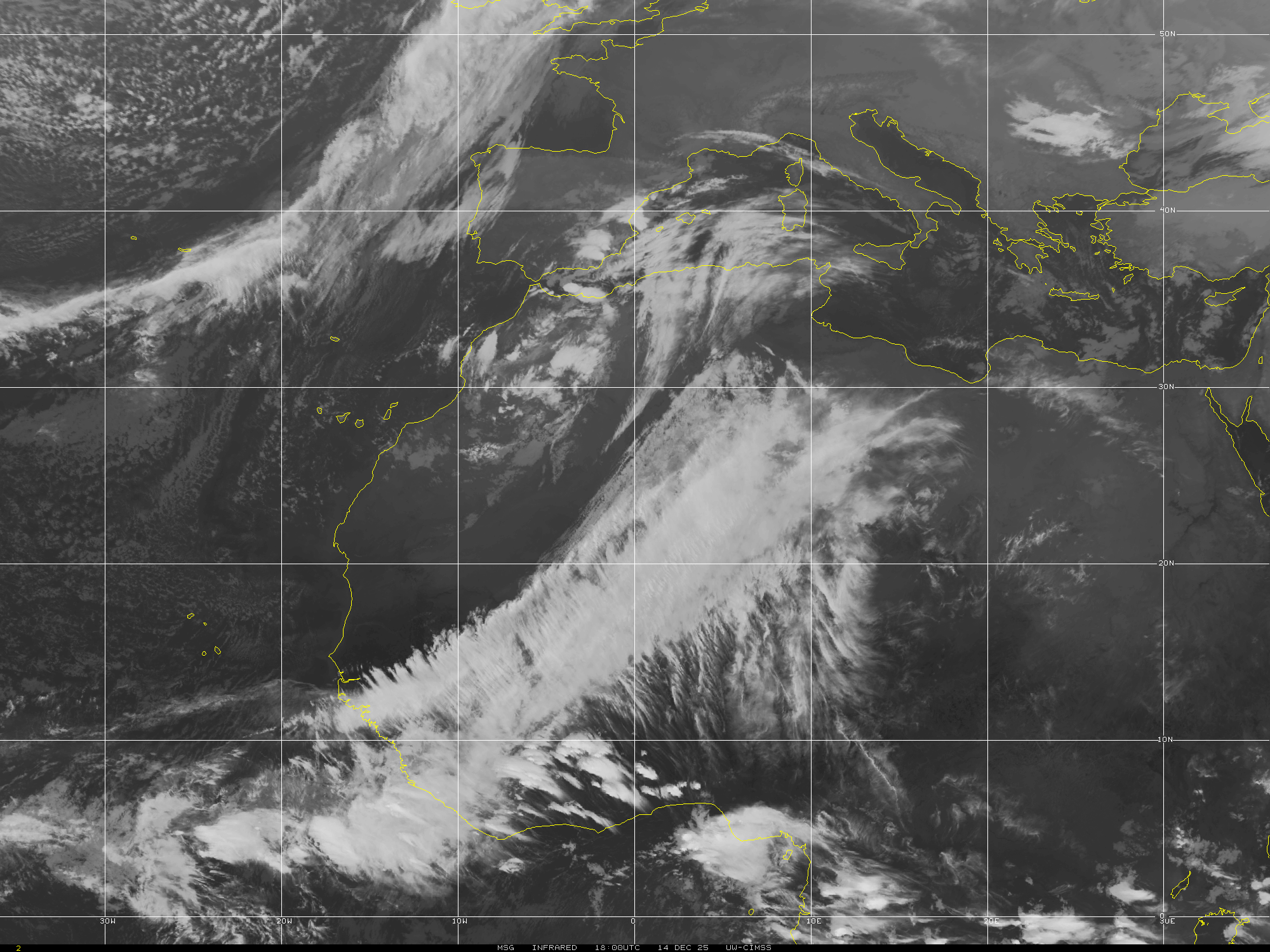
http://tropic.ssec.wisc.edu/real-time/e ... /irnm7.GIF
0 likes
The posts or stuff said are NOT an official forecast. Please look to the NHC and NWS for official forecasts and products.
Floyd-1999, Frances-2004, Jeanne-2004, Fay-2008, Beryl-2012, Debby-2012, Colin-2016, Hermine-2016, Julia-2016, Matthew-2016, Irma-2017, Elsa-2021, Idalia-2023, Debby-2024, Helene-2024.
Go Gators! Go Jags!
Floyd-1999, Frances-2004, Jeanne-2004, Fay-2008, Beryl-2012, Debby-2012, Colin-2016, Hermine-2016, Julia-2016, Matthew-2016, Irma-2017, Elsa-2021, Idalia-2023, Debby-2024, Helene-2024.
Go Gators! Go Jags!
-
tarheelprogrammer
- S2K Supporter
- Posts: 1793
- Joined: Mon Mar 28, 2016 9:25 pm
- Location: Raleigh, NC area (Garner, NC)
Re: 2016 Global Model Runs Discussion (Out to Day 16)
JaxGator wrote:Looks like the wave that will spawn the possible system has formed over Africa. Nice shots of the wave train too.
http://tropic.ssec.wisc.edu/real-time/e ... et7kml.GIF
http://tropic.ssec.wisc.edu/real-time/e ... /irnm7.GIF
Very nice looking wave but all that dry air out there will make it look terrible in a few days. Still a huge wave with plenty of moisture.
0 likes
My posts are not official forecasts. They are just my opinion and may or may not be backed by sound meteorological data. They are NOT endorsed by any professional institution or storm2k.org. For official information, please refer to the NHC and NWS products.
Re: 2016 Global Model Runs Discussion (Out to Day 16)
GFS seems to develop something and then turn into a gyre almost suddenly, so I'm wondering if the model has been having feedback issues the last few runs. I remember something similar happening with Danny last year and Andrea in 2013 as well.
0 likes
The above post is not official and should not be used as such. It is the opinion of the poster and may or may not be backed by sound meteorological data. It is not endorsed by any professional institution or storm2k.org. For official information, please refer to the NHC and NWS products.
-
tarheelprogrammer
- S2K Supporter
- Posts: 1793
- Joined: Mon Mar 28, 2016 9:25 pm
- Location: Raleigh, NC area (Garner, NC)
Re: 2016 Global Model Runs Discussion (Out to Day 16)
GFS has not only caved to the ECMWF but it has completely dropped a storm pretty much. There is always a chance the system/wave organizes quite well and defies the models like Joaquin did last season. However, every time the models hint at a pattern change or something brewing they seem to back off from it. Just an observation.
By the way if the models are correct and nothing forms up to the beginning of August then it will be the longest length of time during a season without a storm forming since 2009 and I could be wrong but it appears to be the last season to go this long a named storm or TD. I am talking solely about length of time without a storm I do know we have had named storms already this season early on.
https://en.wikipedia.org/wiki/2009_Atla ... ane_season
0 likes
My posts are not official forecasts. They are just my opinion and may or may not be backed by sound meteorological data. They are NOT endorsed by any professional institution or storm2k.org. For official information, please refer to the NHC and NWS products.
Who is online
Users browsing this forum: jconsor and 114 guests