ATL: ISAIAS - Models

Moderator: S2k Moderators

Message
Author
User avatar
SouthFLTropics
Category 5
Category 5
Posts: 4236
Age: 50
Joined: Thu Aug 14, 2003 8:04 am
Location: Port St. Lucie, Florida

Re: ATL: NINE - Models

#1041 Postby SouthFLTropics » Tue Jul 28, 2020 6:20 pm

Hypercane_Kyle wrote:How much this thing consolidates tomorrow is going to be critical.


Key time will be tomorrow and through midday and evening on Thursday. Once it clears (IF IT CLEARS) Hispaniola, we'll know better what we're dealing with.
2 likes   
Fourth Generation Florida Native

Personal Storm History: David 79, Andrew 92, Erin 95, Floyd 99, Irene 99, Frances 04, Jeanne 04, Wilma 05, Matthew 16, Irma 17, Ian 22, Nicole 22, Milton 24

User avatar
Evenstar
S2K Supporter
S2K Supporter
Posts: 186
Joined: Mon Aug 11, 2008 1:11 pm
Location: Chesapeake, Virginia

Re: ATL: NINE - Models

#1042 Postby Evenstar » Tue Jul 28, 2020 6:24 pm

Nimbus wrote:Levi said maybe if or when it consolidates north of Puerto Rico on Thursday we can waste our storm2k bandwidth with a forecast for Florida/southeast.

Storm warnings are up for Leewards and Puerto Rico but they will survive.
Just bring in the Lawn furniture and cockatiels..


Save the cockatiels AND the cocktails. I might need both if some of these models are correct. Birds to maintain comms when the power goes down and cocktails for when the birds don't come back.

Cheers!

(Sorry, totally not a model thread-appropriate post, but I'm not a habitual offender and hope our mods will let it slide this time...)
0 likes   
I never received my Hogwarts letter, so I'm leaving the Shire and becoming a Sith Lord.

Ritzcraker
S2K Supporter
S2K Supporter
Posts: 61
Joined: Sun Oct 07, 2018 2:14 am

Re: ATL: NINE - Models

#1043 Postby Ritzcraker » Tue Jul 28, 2020 6:25 pm

SouthFLTropics wrote:HMON TREND

https://i.imgur.com/z0Pihfi.gif


Wouldn’t call one model run a “trend”
2 likes   
This post is NOT AN OFFICIAL FORECAST and should not be used as such. It is just the opinion of the poster and may or may not be backed by sound meteorological data. It is NOT endorsed by any professional institution including storm2k.org. For Official Information please refer to the NHC and NWS products.

User avatar
SouthFLTropics
Category 5
Category 5
Posts: 4236
Age: 50
Joined: Thu Aug 14, 2003 8:04 am
Location: Port St. Lucie, Florida

Re: ATL: NINE - Models

#1044 Postby SouthFLTropics » Tue Jul 28, 2020 6:26 pm

Ritzcraker wrote:
SouthFLTropics wrote:HMON TREND

https://i.imgur.com/z0Pihfi.gif


Wouldn’t call one model run a “trend”


That's what it's called on TT. Can't really think of a better name.
0 likes   
Fourth Generation Florida Native

Personal Storm History: David 79, Andrew 92, Erin 95, Floyd 99, Irene 99, Frances 04, Jeanne 04, Wilma 05, Matthew 16, Irma 17, Ian 22, Nicole 22, Milton 24

User avatar
SouthFLTropics
Category 5
Category 5
Posts: 4236
Age: 50
Joined: Thu Aug 14, 2003 8:04 am
Location: Port St. Lucie, Florida

Re: ATL: NINE - Models

#1045 Postby SouthFLTropics » Tue Jul 28, 2020 6:27 pm

HMON brushes Nassau with the SW eyewall and heads for West End on Grand Bahama Island. The last couple of frames weakened it.
0 likes   
Fourth Generation Florida Native

Personal Storm History: David 79, Andrew 92, Erin 95, Floyd 99, Irene 99, Frances 04, Jeanne 04, Wilma 05, Matthew 16, Irma 17, Ian 22, Nicole 22, Milton 24

User avatar
CM2
Tropical Storm
Tropical Storm
Posts: 103
Joined: Sun Jul 26, 2020 2:41 am

Re: ATL: NINE - Models

#1046 Postby CM2 » Tue Jul 28, 2020 6:27 pm

Ritzcraker wrote:
SouthFLTropics wrote:HMON TREND

https://i.imgur.com/z0Pihfi.gif


Wouldn’t call one model run a “trend”

A trend I do notice is the reduction of dry air between runs.
3 likes   
Large Signatures are for losers.
The posts in this forum are NOT official forecasts and should not be used as such. They are just the opinion of the poster and may or may not be backed by sound meteorological data. They are NOT endorsed by any professional institution or STORM2K. For official information, please refer to products from the NHC and NWS.

AutoPenalti
Category 5
Category 5
Posts: 4030
Age: 29
Joined: Mon Aug 17, 2015 4:16 pm
Location: Ft. Lauderdale, Florida

Re: ATL: NINE - Models

#1047 Postby AutoPenalti » Tue Jul 28, 2020 6:28 pm

SouthFLTropics wrote:
Ritzcraker wrote:
SouthFLTropics wrote:HMON TREND

https://i.imgur.com/z0Pihfi.gif


Wouldn’t call one model run a “trend”


That's what it's called on TT. Can't really think of a better name.

A comparison of different runs?
0 likes   
The posts in this forum are NOT official forecasts and should not be used as such. They are just the opinion of the poster and may or may not be backed by sound meteorological data. They are NOT endorsed by any professional institution or STORM2K. For official information, please refer to products from the NHC and NWS.


Model Runs Cheat Sheet:
GFS (5:30 AM/PM, 11:30 AM/PM)
HWRF, GFDL, UKMET, NAVGEM (6:30-8:00 AM/PM, 12:30-2:00 AM/PM)
ECMWF (1:45 AM/PM)

TCVN
is a weighted averaged

HurricaneFrances04
Category 2
Category 2
Posts: 597
Joined: Mon Jun 25, 2012 8:09 am
Location: Fort Lauderdale, Florida

Re: ATL: NINE - Models

#1048 Postby HurricaneFrances04 » Tue Jul 28, 2020 6:33 pm

Image
0 likes   

User avatar
SFLcane
S2K Supporter
S2K Supporter
Posts: 10163
Age: 47
Joined: Sat Jun 05, 2010 1:44 pm
Location: Lake Worth Florida

Re: ATL: NINE - Models

#1049 Postby SFLcane » Tue Jul 28, 2020 6:46 pm

18z HWRF/para has a strengthening hurricane 979mb heading straight for SFL. :eek:
0 likes   

User avatar
Blown Away
S2K Supporter
S2K Supporter
Posts: 10147
Joined: Wed May 26, 2004 6:17 am

Re: ATL: NINE - Models

#1050 Postby Blown Away » Tue Jul 28, 2020 6:47 pm

HurricaneFrances04 wrote:https://i.imgur.com/A79UNvA.png


The NHC 5pm position was 14.4/55.9 which is a full degree N of the 18z GFS initial point?
Last edited by Blown Away on Tue Jul 28, 2020 6:48 pm, edited 1 time in total.
0 likes   
Hurricane Eye Experience: David 79, Irene 99, Frances 04, Jeanne 04, Wilma 05... EYE COMING MY WAY IN 2024…
Hurricane Brush Experience: Andrew 92, Erin 95, Floyd 99, Matthew 16, Irma 17, Ian 22, Nicole 22…

User avatar
SouthFLTropics
Category 5
Category 5
Posts: 4236
Age: 50
Joined: Thu Aug 14, 2003 8:04 am
Location: Port St. Lucie, Florida

Re: ATL: NINE - Models

#1051 Postby SouthFLTropics » Tue Jul 28, 2020 6:48 pm

SFLcane wrote:18z HWRF/para has a strengthening hurricane 979mb heading straight for SFL. :eek:


It's going to be a close call I think. Looks like it may be starting to turn just after Andros. Maybe ride the Gulf Stream to the North.
0 likes   
Fourth Generation Florida Native

Personal Storm History: David 79, Andrew 92, Erin 95, Floyd 99, Irene 99, Frances 04, Jeanne 04, Wilma 05, Matthew 16, Irma 17, Ian 22, Nicole 22, Milton 24

User avatar
SFLcane
S2K Supporter
S2K Supporter
Posts: 10163
Age: 47
Joined: Sat Jun 05, 2010 1:44 pm
Location: Lake Worth Florida

Re: ATL: NINE - Models

#1052 Postby SFLcane » Tue Jul 28, 2020 6:50 pm

Image
Last edited by SFLcane on Tue Jul 28, 2020 6:52 pm, edited 2 times in total.
0 likes   

User avatar
AubreyStorm
Category 1
Category 1
Posts: 337
Age: 44
Joined: Fri Jun 16, 2017 6:21 pm
Location: Texas, USA

Re: ATL: NINE - Models

#1053 Postby AubreyStorm » Tue Jul 28, 2020 6:50 pm

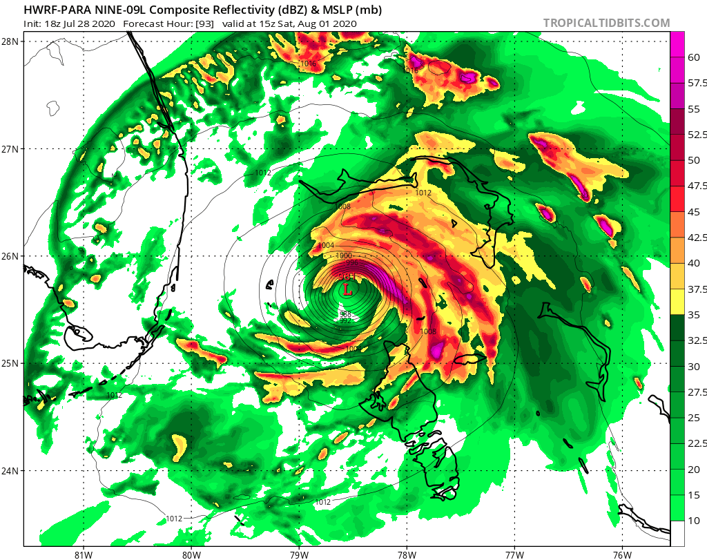
CM2 wrote:HWRF keeps having a strengthening trend. Quite interesting
https://imgur.com/vvViNiA


992mb it’s Cat 1?
0 likes   
The posts are NOT an official forecast. Please REFER to the NHC and NWS for official forecasts and products.

AutoPenalti
Category 5
Category 5
Posts: 4030
Age: 29
Joined: Mon Aug 17, 2015 4:16 pm
Location: Ft. Lauderdale, Florida

Re: ATL: NINE - Models

#1054 Postby AutoPenalti » Tue Jul 28, 2020 6:58 pm

Talk about game of inches...
0 likes   
The posts in this forum are NOT official forecasts and should not be used as such. They are just the opinion of the poster and may or may not be backed by sound meteorological data. They are NOT endorsed by any professional institution or STORM2K. For official information, please refer to products from the NHC and NWS.


Model Runs Cheat Sheet:
GFS (5:30 AM/PM, 11:30 AM/PM)
HWRF, GFDL, UKMET, NAVGEM (6:30-8:00 AM/PM, 12:30-2:00 AM/PM)
ECMWF (1:45 AM/PM)

TCVN
is a weighted averaged

Aric Dunn
Category 5
Category 5
Posts: 21238
Age: 42
Joined: Sun Sep 19, 2004 9:58 pm
Location: Ready for the Chase.
Contact:

Re: ATL: NINE - Models

#1055 Postby Aric Dunn » Tue Jul 28, 2020 6:58 pm

regular HWRF start to slow down around andros and drift back wnw towards florida at 105 hours
0 likes   
Note: If I make a post that is brief. Please refer back to previous posts for the analysis or reasoning. I do not re-write/qoute what my initial post said each time.
If there is nothing before... then just ask :)

Space & Atmospheric Physicist, Embry-Riddle Aeronautical University,
I believe the sky is falling...

User avatar
SouthFLTropics
Category 5
Category 5
Posts: 4236
Age: 50
Joined: Thu Aug 14, 2003 8:04 am
Location: Port St. Lucie, Florida

Re: ATL: NINE - Models

#1056 Postby SouthFLTropics » Tue Jul 28, 2020 7:02 pm

HWRF Para missed some frames and the money shot but based on the most recent image it looks like right on the coast right by your house BlownAway.
1 likes   
Fourth Generation Florida Native

Personal Storm History: David 79, Andrew 92, Erin 95, Floyd 99, Irene 99, Frances 04, Jeanne 04, Wilma 05, Matthew 16, Irma 17, Ian 22, Nicole 22, Milton 24

Aric Dunn
Category 5
Category 5
Posts: 21238
Age: 42
Joined: Sun Sep 19, 2004 9:58 pm
Location: Ready for the Chase.
Contact:

Re: ATL: NINE - Models

#1057 Postby Aric Dunn » Tue Jul 28, 2020 7:05 pm

HWRF regular is also pretty sheared the entire time...
0 likes   
Note: If I make a post that is brief. Please refer back to previous posts for the analysis or reasoning. I do not re-write/qoute what my initial post said each time.
If there is nothing before... then just ask :)

Space & Atmospheric Physicist, Embry-Riddle Aeronautical University,
I believe the sky is falling...

bohai
Tropical Depression
Tropical Depression
Posts: 76
Age: 65
Joined: Tue Jun 02, 2020 12:57 pm
Location: Comfort, TX

Re: ATL: NINE - Models

#1058 Postby bohai » Tue Jul 28, 2020 7:06 pm

If it rides the GulfStream and is a formidable TS or C1H, that will play havoc with areas that Sandy ravaged years back and the surge would be horrendous if the models pan out to move it northward and not really OTS.
0 likes   

User avatar
DestinHurricane
Category 4
Category 4
Posts: 935
Joined: Tue May 01, 2018 8:05 am
Location: New York, NY

Re: ATL: NINE - Models

#1059 Postby DestinHurricane » Tue Jul 28, 2020 7:09 pm

GFS Para coming in a little stronger.
0 likes   
Michael 2018

HurricaneFrances04
Category 2
Category 2
Posts: 597
Joined: Mon Jun 25, 2012 8:09 am
Location: Fort Lauderdale, Florida

Re: ATL: NINE - Models

#1060 Postby HurricaneFrances04 » Tue Jul 28, 2020 7:09 pm

Blown Away wrote:
HurricaneFrances04 wrote:https://i.imgur.com/A79UNvA.png


The NHC 5pm position was 14.4/55.9 which is a full degree N of the 18z GFS initial point?


Doesn't the 18Z use the 2 pm position which was 14.1n 54.8w? Either way, looks like it may be a bit off.
0 likes   


Return to “2020”

Who is online

Users browsing this forum: StormWeather and 15 guests