If this verified I expect multiple Fl threats come ASO.
Moderator: S2k Moderators


AxaltaRacing24 wrote:I feel that the lack of season cancel this year is because there are very alarming signs that this season will be at least above average. Once you look at the activity we have left along with the steering near peak season, there is not much left to do other than simply wait for what we might be in for.

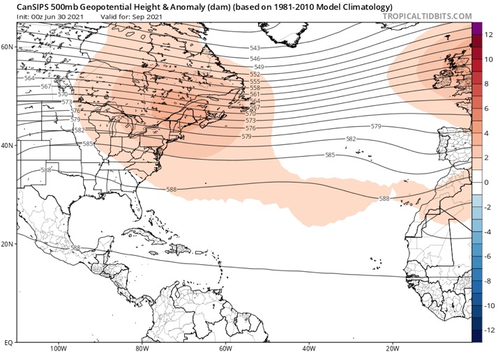
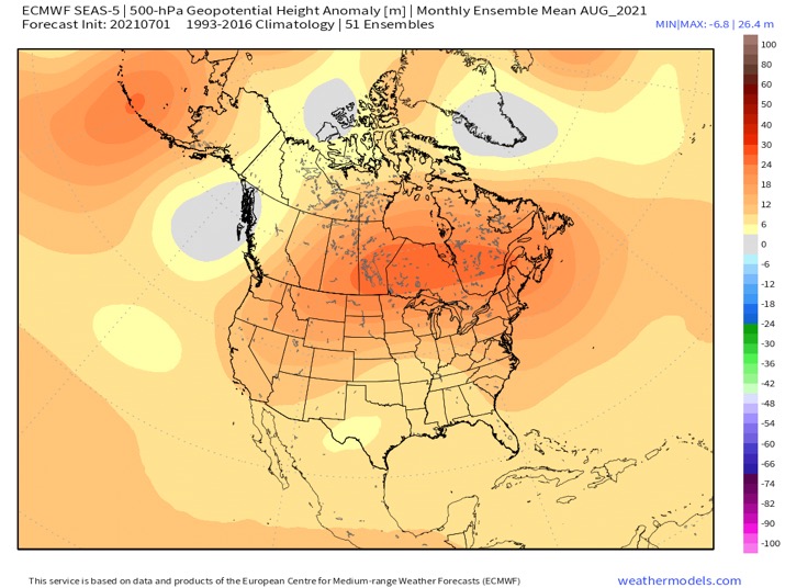
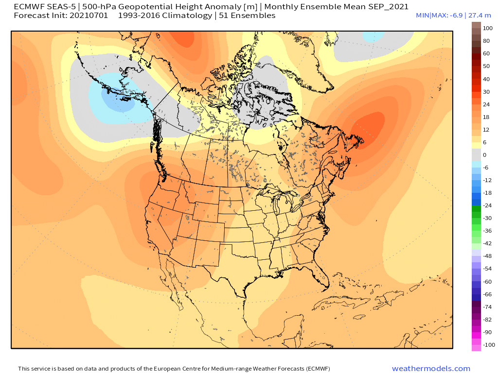
SFLcane wrote:Scary Z500 combo here… Euro and Cánsips
If this verified I expect multiple Fl threats come ASO.
https://i.postimg.cc/qv8Nmwqh/7-F446396-8-C96-4096-9-CE4-D2-D6-E13-D92-FA.jpg
https://i.postimg.cc/Sx0X73Sb/9-BB43-B3-C-63-EE-4-AB2-9858-E951-CD258138.jpg
toad strangler wrote:SFLcane wrote:Scary Z500 combo here… Euro and Cánsips
If this verified I expect multiple Fl threats come ASO.
https://i.postimg.cc/qv8Nmwqh/7-F446396-8-C96-4096-9-CE4-D2-D6-E13-D92-FA.jpg
https://i.postimg.cc/Sx0X73Sb/9-BB43-B3-C-63-EE-4-AB2-9858-E951-CD258138.jpg
I think this deserves another
Waiting on NOAA now

Category5Kaiju wrote:AxaltaRacing24 wrote:I feel that the lack of season cancel this year is because there are very alarming signs that this season will be at least above average. Once you look at the activity we have left along with the steering near peak season, there is not much left to do other than simply wait for what we might be in for.
Oh believe me, at least on social media I have personally seen some people still cancel this season without any credible or accurate evidence for doing so. For example one person simply said "oh, this is not going to be active at all" without even putting in the effort to support his/her claim while another said "because last year we had 30 named storms last year I feel we are only going to have 14 in total this year. This year is not going to be busy because last year we went Greek and were very busy."
DestinHurricane wrote:From CSU:In general, early season Atlantic hurricane activity has very little correlation with
overall Atlantic hurricane activity. However, when this activity occurs in the tropics
(south of 23.5°N), that is typically a harbinger of a very active season. Hurricane Elsa
formed in the tropical Atlantic and then tracked into the eastern Caribbean (10-20°N, 75-
60°W) at hurricane strength. Since 1900, only six other years have had eastern Caribbean
hurricanes prior to 1 August: 1926, 1933, 1961, 1996, 2005 and 2020. All six of those
years were classified as hyperactive Atlantic hurricane seasons using the NOAA Atlantic
hurricane season definition (>=160 ACE).
While I do think 2021 will be an above average season, maybe even hyperactive especially now that Cool-Neutral or La Nina looks likely during the peak months. I disagree that Elsa is a sign of an active season. All of the years they mentioned, 1926, 1933, 1961, 1996, 2005 and 2020, had long lived hurricanes in the eastern Caribbean. Elsa was able to jump to hurricane for a few hours before it weakened back down, unlike the aforementioned seasons' E Carib hurricanes. The fact that Elsa was not able to maintain hurricane intensity through the Eastern Caribbean due to wind shear doesn't necessarily point to an inactive season, I just don't think it means the season will be hyperactive (though it may be, just wont be because of Elsa). Elsa did not find very favorable conditions in the eastern Caribbean, which is expected in july, even in an above average season. Some of the most active seasons such as 2017 don't have hurricanes in the e Caribbean in July.


Shell Mound wrote:DestinHurricane wrote:From CSU:In general, early season Atlantic hurricane activity has very little correlation with
overall Atlantic hurricane activity. However, when this activity occurs in the tropics
(south of 23.5°N), that is typically a harbinger of a very active season. Hurricane Elsa
formed in the tropical Atlantic and then tracked into the eastern Caribbean (10-20°N, 75-
60°W) at hurricane strength. Since 1900, only six other years have had eastern Caribbean
hurricanes prior to 1 August: 1926, 1933, 1961, 1996, 2005 and 2020. All six of those
years were classified as hyperactive Atlantic hurricane seasons using the NOAA Atlantic
hurricane season definition (>=160 ACE).
While I do think 2021 will be an above average season, maybe even hyperactive especially now that Cool-Neutral or La Nina looks likely during the peak months. I disagree that Elsa is a sign of an active season. All of the years they mentioned, 1926, 1933, 1961, 1996, 2005 and 2020, had long lived hurricanes in the eastern Caribbean. Elsa was able to jump to hurricane for a few hours before it weakened back down, unlike the aforementioned seasons' E Carib hurricanes. The fact that Elsa was not able to maintain hurricane intensity through the Eastern Caribbean due to wind shear doesn't necessarily point to an inactive season, I just don't think it means the season will be hyperactive (though it may be, just wont be because of Elsa). Elsa did not find very favorable conditions in the eastern Caribbean, which is expected in july, even in an above average season. Some of the most active seasons such as 2017 don't have hurricanes in the e Caribbean in July.
https://i.ibb.co/J78c7qy/Ska-rmavbild-2021-07-10-kl-17-09-29.png
Of the first five seasons, 1933, 1996, and 2005 each featured two or more hurricanes in the Caribbean in July. Storms #2 and #5 in 1933 strengthened as they tracked through the Caribbean, as did Bertha in Cesar in 1996, to not mention Dennis and Emily in 2005. All of these cyclones, along with Storm #1 of 1926, intensified steadily as they passed through the Caribbean. Storm #1 of 1926 actually strengthened to 90 kt before making landfall over Cabo Rojo, Puerto Rico. 1961’s Anna actually deepened to 90 kt over the west-central Caribbean Sea before striking Central America with winds of 70 to 75 kt. So I would definitely consider 1926, 1933, 1996, and 2005 to be more impressive than either 2020 or 2021 thus far, as conditions in the Caribbean were evidently more conducive than we have seen this year to date.
CyclonicFury wrote:Shell Mound wrote:DestinHurricane wrote:From CSU:
While I do think 2021 will be an above average season, maybe even hyperactive especially now that Cool-Neutral or La Nina looks likely during the peak months. I disagree that Elsa is a sign of an active season. All of the years they mentioned, 1926, 1933, 1961, 1996, 2005 and 2020, had long lived hurricanes in the eastern Caribbean. Elsa was able to jump to hurricane for a few hours before it weakened back down, unlike the aforementioned seasons' E Carib hurricanes. The fact that Elsa was not able to maintain hurricane intensity through the Eastern Caribbean due to wind shear doesn't necessarily point to an inactive season, I just don't think it means the season will be hyperactive (though it may be, just wont be because of Elsa). Elsa did not find very favorable conditions in the eastern Caribbean, which is expected in july, even in an above average season. Some of the most active seasons such as 2017 don't have hurricanes in the e Caribbean in July.
https://i.ibb.co/J78c7qy/Ska-rmavbild-2021-07-10-kl-17-09-29.png
Of the first five seasons, 1933, 1996, and 2005 each featured two or more hurricanes in the Caribbean in July. Storms #2 and #5 in 1933 strengthened as they tracked through the Caribbean, as did Bertha in Cesar in 1996, to not mention Dennis and Emily in 2005. All of these cyclones, along with Storm #1 of 1926, intensified steadily as they passed through the Caribbean. Storm #1 of 1926 actually strengthened to 90 kt before making landfall over Cabo Rojo, Puerto Rico. 1961’s Anna actually deepened to 90 kt over the west-central Caribbean Sea before striking Central America with winds of 70 to 75 kt. So I would definitely consider 1926, 1933, 1996, and 2005 to be more impressive than either 2020 or 2021 thus far, as conditions in the Caribbean were evidently more conducive than we have seen this year to date.
The fact that Elsa was able to become a hurricane east of the Lesser Antilles on July 2, the earliest MDR hurricane in the satellite era, is significant. It also remained a hurricane in the eastern Caribbean for a while. It survived the Caribbean "graveyard" without opening up into a wave, which is remarkable for a July storm.
I like to bring up Bret and Don in 2017 as a counterargument for those that say Elsa weakening is a sign the eastern Caribbean isn't as favorable as thought. Bret and Don both opened up into a wave near the Windward Islands, and 2017 went on to have two Category 5 hurricanes hit the Lesser Antilles. Unlike Bret and Don, Elsa survived as a TC all the way from the MDR to the US, which is rare for a July storm.
It seems like you are reaching for the slightest signs the season may not be as active as expected, or that FL won't be hit this year.

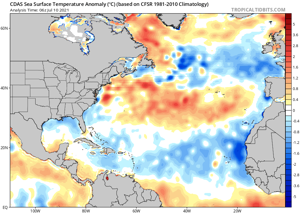
gatorcane wrote:Seeing quite a number of posts on how Florida, particularly South Florida, is under the gun this year. My feeling is likely not. I am basing this on a couple of possible indicators which probably don’t hold a lot of merit but 1) water temps have felt cooler than I can remember in years past. By now usually the water does not feel cold to go into 2) it took a lot longer than normal to get into the rainy season going here than in years past. Indeed looking at the SST anomaly picture out there we see a big swath of cooler than normal waters near Florida and the Bahamas out through a lot of the MDR. Of course the waters will warm as the summer goes on but just not as warm as I can remember in many years past.
https://i.postimg.cc/7PTkP3jr/cdas-sflux-ssta-atl-1.png
Category5Kaiju wrote:CyclonicFury wrote:Shell Mound wrote:https://i.ibb.co/J78c7qy/Ska-rmavbild-2021-07-10-kl-17-09-29.png
Of the first five seasons, 1933, 1996, and 2005 each featured two or more hurricanes in the Caribbean in July. Storms #2 and #5 in 1933 strengthened as they tracked through the Caribbean, as did Bertha in Cesar in 1996, to not mention Dennis and Emily in 2005. All of these cyclones, along with Storm #1 of 1926, intensified steadily as they passed through the Caribbean. Storm #1 of 1926 actually strengthened to 90 kt before making landfall over Cabo Rojo, Puerto Rico. 1961’s Anna actually deepened to 90 kt over the west-central Caribbean Sea before striking Central America with winds of 70 to 75 kt. So I would definitely consider 1926, 1933, 1996, and 2005 to be more impressive than either 2020 or 2021 thus far, as conditions in the Caribbean were evidently more conducive than we have seen this year to date.
The fact that Elsa was able to become a hurricane east of the Lesser Antilles on July 2, the earliest MDR hurricane in the satellite era, is significant. It also remained a hurricane in the eastern Caribbean for a while. It survived the Caribbean "graveyard" without opening up into a wave, which is remarkable for a July storm.
I like to bring up Bret and Don in 2017 as a counterargument for those that say Elsa weakening is a sign the eastern Caribbean isn't as favorable as thought. Bret and Don both opened up into a wave near the Windward Islands, and 2017 went on to have two Category 5 hurricanes hit the Lesser Antilles. Unlike Bret and Don, Elsa survived as a TC all the way from the MDR to the US, which is rare for a July storm.
It seems like you are reaching for the slightest signs the season may not be as active as expected, or that FL won't be hit this year.
Heck, take hyperactive 1950, 1969, 1995, 1998, 1999, 2004, and 2010 into consideration too. Some of those years went on to get an ACE score in the very high 100s and some even over 200, yet none of theme featured a July MDR hurricane. I agree, that in itself is what matters, and of course I don't mean any criticism or offense toward Shell Mound in any manner and appreciate Shell Mound's regular posts on this forum, but I would caution against searching for even the smallest (and oftentimes very insignificant in the grand scheme of things) signs that this season would not be active. It's better to be safe and prepare as if this season will be active rather than be sorry after taking such relatively minor factors and blowing them out of proportion to wishcast and condition oneself to think that this season won't be as big of a deal.
gatorcane wrote:Seeing quite a number of posts on how Florida, particularly South Florida, is under the gun this year. My feeling is likely not. I am basing this on a couple of possible indicators which probably don’t hold a lot of merit but 1) water temps have felt cooler than I can remember in years past. By now usually the water does not feel cold to go into 2) it took a lot longer than normal to get into the rainy season going here than in years past. Even into early June some parts of South Florida were seeing dew points below 70F which is really unheard of. Indeed looking at the SST anomaly picture out there we see a big swath of cooler than normal waters near Florida and the Bahamas out through a lot of the MDR. Of course the waters will warm as the summer goes on but just not as warm as I can remember in many years past.
https://i.postimg.cc/7PTkP3jr/cdas-sflux-ssta-atl-1.png

Users browsing this forum: StormPyrate and 257 guests
