2022 Global Model Runs Discussion (Out thru day 16)
Moderator: S2k Moderators
Forum rules

The posts in this forum are NOT official forecasts and should not be used as such. They are just the opinion of the poster and may or may not be backed by sound meteorological data. They are NOT endorsed by any professional institution or STORM2K. For official information, please refer to products from the National Hurricane Center and National Weather Service.
-
Category5Kaiju

- Category 5

- Posts: 4332
- Joined: Thu Dec 24, 2020 12:45 pm
- Location: Seattle and Phoenix
Re: 2022 Global Model Runs Discussion (Out thru day 16)
The latest GFS run looks fun for sure 
1 likes
Unless explicitly stated, all info in my posts is based on my own opinions and observations. Tropical storms and hurricanes can be extremely dangerous. Refer to an accredited weather research agency or meteorologist if you need to make serious decisions regarding an approaching storm.
-
captainbarbossa19

- Professional-Met

- Posts: 1094
- Age: 27
- Joined: Wed Aug 21, 2019 11:09 pm
- Location: Beaumont, TX
Re: 2022 Global Model Runs Discussion (Out thru day 16)
Category5Kaiju wrote:The latest GFS run looks fun for sure
Looks like it's mainly picking up on more favorable conditions entering the basin soon. As usual, it should be most favorable in the western part first.
2 likes
-
cycloneye

- Admin

- Posts: 149414
- Age: 69
- Joined: Thu Oct 10, 2002 10:54 am
- Location: San Juan, Puerto Rico
Re: 2022 Global Model Runs Discussion (Out thru day 16)
2 likes
Visit the Caribbean-Central America Weather Thread where you can find at first post web cams,radars
and observations from Caribbean basin members Click Here
and observations from Caribbean basin members Click Here
-
lsuhurricane
- Category 1

- Posts: 270
- Joined: Tue Aug 15, 2017 2:53 pm
Re: 2022 Global Model Runs Discussion (Out thru day 16)
GFS Ensembles are crazy bullish as well in the 8-10 day mark. Won’t have to wait long to see if the West Caribbean is favored over the EPaC
0 likes

Re: 2022 Global Model Runs Discussion (Out thru day 16)
Category5Kaiju wrote:The latest GFS run looks fun for sure
This is most likely overblown, but I've always been concerned that anything entering the Gulf this year has the potential to go places. Among the pre-Bonnie ensemble runs and a handful active EPS ensemble runs for July and August, almost all tracks that somehow ended up in Gulf intensified to hurricanes and even majors.
0 likes
TC naming lists: retirements and intensity
Most aggressive Advisory #1's in North Atlantic (cr. kevin for starting the list)
Most aggressive Advisory #1's in North Atlantic (cr. kevin for starting the list)
-
hurricane2025
- Category 1
- Posts: 254
- Joined: Thu Apr 08, 2021 10:36 am
Re: 2022 Global Model Runs Discussion (Out thru day 16)
I mean sooner or later it’s going to crank, it’s august so gfs could be on to something .
2 likes
-
Blown Away

- S2K Supporter

- Posts: 10253
- Joined: Wed May 26, 2004 6:17 am
Re: 2022 Global Model Runs Discussion (Out thru day 16)
Teban54 wrote:Category5Kaiju wrote:The latest GFS run looks fun for sure
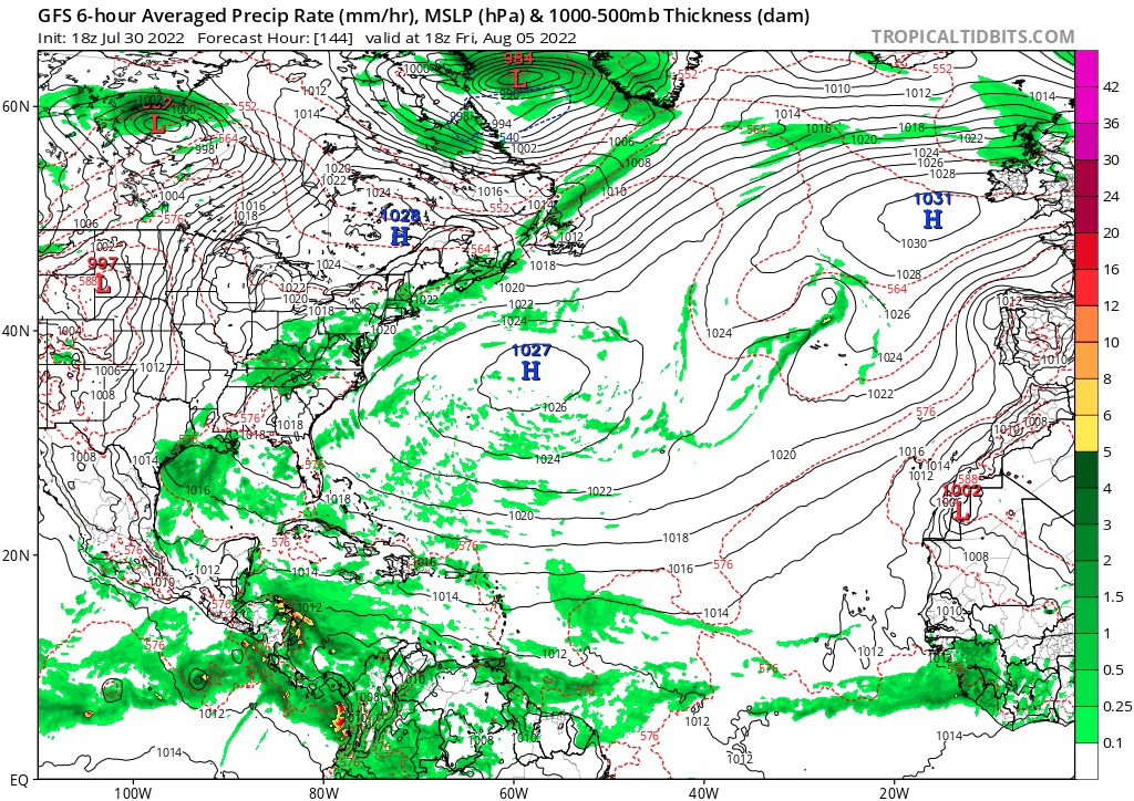
https://i.postimg.cc/pXg5FrKT/gfs-mslp-pcpn-atl-fh144-384.gif
This is most likely overblown, but I've always been concerned that anything entering the Gulf this year has the potential to go places. Among the pre-Bonnie ensemble runs and a handful active EPS ensemble runs for July and August, almost all tracks that somehow ended up in Gulf intensified to hurricanes and even majors.
Wow, TS to maybe Cat 4/5 in 72 hours. That’s impressive!
0 likes
Hurricane Eye Experience: David 79, Irene 99, Frances 04, Jeanne 04, Wilma 05… Hurricane Brush Experience: Andrew 92, Erin 95, Floyd 99, Matthew 16, Irma 17, Ian 22, Nicole 22…
-
ElectricStorm

- Category 5
- Posts: 5146
- Age: 25
- Joined: Tue Aug 13, 2019 11:23 pm
- Location: Norman, OK
Re: 2022 Global Model Runs Discussion (Out thru day 16)
Happy hour GFS doing happy hour GFS things
5 likes
B.S Meteorology, University of Oklahoma '25
Please refer to the NHC, NWS, or SPC for official information.
Please refer to the NHC, NWS, or SPC for official information.
-
cycloneye
- Admin
- Posts: 149414
- Age: 69
- Joined: Thu Oct 10, 2002 10:54 am
- Location: San Juan, Puerto Rico
Re: 2022 Global Model Runs Discussion (Out thru day 16)
First run, long range. Leave the confetti stored. Let the runs come plus other models joining.
3 likes
Visit the Caribbean-Central America Weather Thread where you can find at first post web cams,radars
and observations from Caribbean basin members Click Here
and observations from Caribbean basin members Click Here
-
Blown Away
- S2K Supporter
- Posts: 10253
- Joined: Wed May 26, 2004 6:17 am
Re: 2022 Global Model Runs Discussion (Out thru day 16)
Teban54 wrote:Category5Kaiju wrote:The latest GFS run looks fun for sure
https://i.postimg.cc/pXg5FrKT/gfs-mslp-pcpn-atl-fh144-384.gif
This is most likely overblown, but I've always been concerned that anything entering the Gulf this year has the potential to go places. Among the pre-Bonnie ensemble runs and a handful active EPS ensemble runs for July and August, almost all tracks that somehow ended up in Gulf intensified to hurricanes and even majors.
Wow, TS to maybe Cat 4/5 in 72 hours. That’s impressive!
0 likes
Hurricane Eye Experience: David 79, Irene 99, Frances 04, Jeanne 04, Wilma 05… Hurricane Brush Experience: Andrew 92, Erin 95, Floyd 99, Matthew 16, Irma 17, Ian 22, Nicole 22…
-
Blown Away
- S2K Supporter
- Posts: 10253
- Joined: Wed May 26, 2004 6:17 am
Re: 2022 Global Model Runs Discussion (Out thru day 16)
cycloneye wrote:First run, long range. Leave the confetti stored. Let the runs come plus other models joining.
Natives are getting restless, 18z GFS came through in the clutch!
1 likes
Hurricane Eye Experience: David 79, Irene 99, Frances 04, Jeanne 04, Wilma 05… Hurricane Brush Experience: Andrew 92, Erin 95, Floyd 99, Matthew 16, Irma 17, Ian 22, Nicole 22…
-
SFLcane

- S2K Supporter
- Posts: 10281
- Age: 48
- Joined: Sat Jun 05, 2010 1:44 pm
- Location: Lake Worth Florida
Re: 2022 Global Model Runs Discussion (Out thru day 16)
Your typical gfs/Gefs Ba, ba, ba, bias.
1 likes
-
Category5Kaiju
- Category 5
- Posts: 4332
- Joined: Thu Dec 24, 2020 12:45 pm
- Location: Seattle and Phoenix
Re: 2022 Global Model Runs Discussion (Out thru day 16)
ElectricStorm wrote:Happy hour GFS doing happy hour GFS things
But what if...just what if...this is the moment that the GFS actually hits the jackpot? Like throwing darts constantly (as it did the past many months) and finally hitting the bullseye?
0 likes
Unless explicitly stated, all info in my posts is based on my own opinions and observations. Tropical storms and hurricanes can be extremely dangerous. Refer to an accredited weather research agency or meteorologist if you need to make serious decisions regarding an approaching storm.


Re: 2022 Global Model Runs Discussion (Out thru day 16)
Category5Kaiju wrote:ElectricStorm wrote:Happy hour GFS doing happy hour GFS things
But what if...just what if...this is the moment that the GFS actually hits the jackpot? Like throwing darts constantly (as it did the past many months) and finally hitting the bullseye?
GFS has dueling hurricanes in the EPAC and ATL, that doesn't look likely. Plus it's in the 300+ hour range which is highly susceptible to disappearing the next run. If we can't trust them 5 days out clearly not 10 or 15
4 likes
The above post and any post by Ntxw is NOT an official forecast and should not be used as such. It is just the opinion of the poster and may or may not be backed by sound meteorological data. It is NOT endorsed by any professional institution including Storm2k. For official information, please refer to NWS products.
Help support Storm2K!
-
Clearcloudz

- Category 2

- Posts: 540
- Joined: Sun Jun 10, 2018 1:46 pm
- Location: Rosenberg TX
Re: 2022 Global Model Runs Discussion (Out thru day 16)
18Z GEFS some very strong members. This could be very wrong given the GFS bias.

Compare that to the 12Z EURO ensembles and huge difference.

Compare that to the 12Z EURO ensembles and huge difference.
0 likes
-
MGC

- S2K Supporter
- Posts: 5940
- Joined: Sun Mar 23, 2003 9:05 pm
- Location: Pass Christian MS, or what is left.
Re: 2022 Global Model Runs Discussion (Out thru day 16)
ElectricStorm wrote:Happy hour GFS doing happy hour GFS things
Eventually the GFS will get one right.......MGC
0 likes
-
gatorcane

- S2K Supporter
- Posts: 23708
- Age: 48
- Joined: Sun Mar 13, 2005 3:54 pm
- Location: Boca Raton, FL
Re: 2022 Global Model Runs Discussion (Out thru day 16)
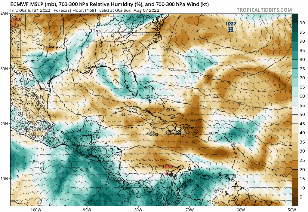
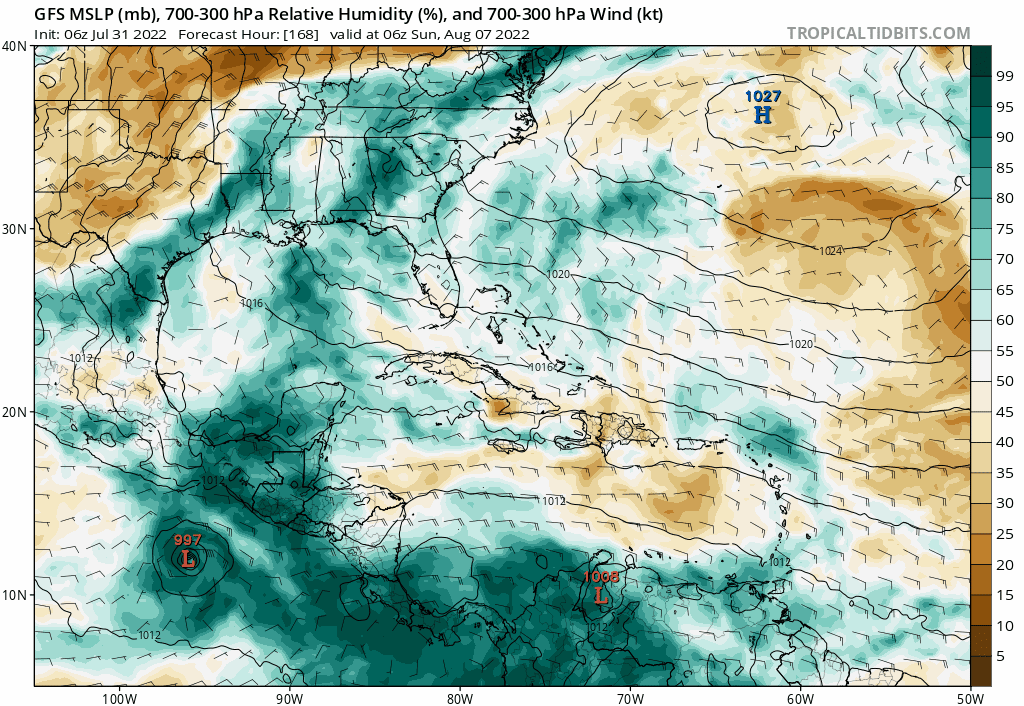
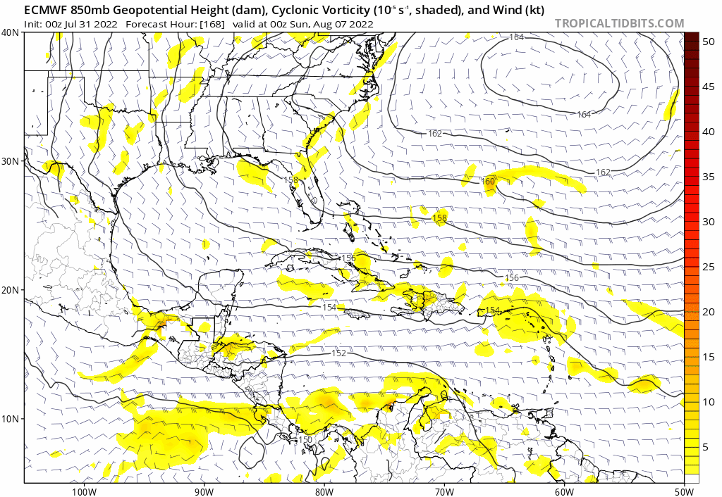
Really slow on the models now, but one thing catching my eye in the long-range is this tropical wave which the ECMWF moves through the Bahamas while increasing the vorticity while the GFS recurves it and develops off the Carolinas (240+ hours not shown). There’s a lot of dry air around and we are probably a few weeks early for development of Cape Verde waves but something to at least watch:
It is best to see this wave on the TT relative humidity charts from 168-240 hours:
Euro 850mb vorticity
It is best to see this wave on the TT relative humidity charts from 168-240 hours:
Euro 850mb vorticity
1 likes

Re: 2022 Global Model Runs Discussion (Out thru day 16)
gatorcane wrote:Really slow on the models now, but one thing catching my eye in the long-range is this tropical wave which the ECMWF moves through the Bahamas while increasing the vorticity while the GFS recurves it and develops off the Carolinas (240+ hours not shown). There’s a lot of dry air around and we are probably a few weeks early for development of Cape Verde waves but something to at least watch:
It is best to see this wave on the TT relative humidity charts from 168-240 hours:
https://i.postimg.cc/B6VzjCLm/ecmwf-mid-RH-watl-fh168-240.gif
https://i.postimg.cc/LsrCR8rW/gfs-mid-RH-watl-fh168-240.gif
Euro 850mb vorticity
https://i.postimg.cc/LXxJLJ2C/ecmwf-z850-vort-watl-fh168-240.gif
It also caught my eyes this morning, it is on its long range forecast but for at least 5 runs in a row it shows this TW to approach the Lesser Antilles next weekend and track north of the Caribbean where it could have the best UL environment for development. Very little support for development from the EPS, for now.
1 likes
-
cycloneye
- Admin
- Posts: 149414
- Age: 69
- Joined: Thu Oct 10, 2002 10:54 am
- Location: San Juan, Puerto Rico
Re: 2022 Global Model Runs Discussion (Out thru day 16)
NDG wrote:gatorcane wrote:Really slow on the models now, but one thing catching my eye in the long-range is this tropical wave which the ECMWF moves through the Bahamas while increasing the vorticity while the GFS recurves it and develops off the Carolinas (240+ hours not shown). There’s a lot of dry air around and we are probably a few weeks early for development of Cape Verde waves but something to at least watch:
It is best to see this wave on the TT relative humidity charts from 168-240 hours:
https://i.postimg.cc/B6VzjCLm/ecmwf-mid-RH-watl-fh168-240.gif
https://i.postimg.cc/LsrCR8rW/gfs-mid-RH-watl-fh168-240.gif
Euro 850mb vorticity
https://i.postimg.cc/LXxJLJ2C/ecmwf-z850-vort-watl-fh168-240.gif
It also caught my eyes this morning, it is on its long range forecast but for at least 5 runs in a row it shows this TW to approach the Lesser Antilles next weekend and track north of the Caribbean where it could have the best UL environment for development. Very little support for development from the EPS, for now.
See it here. 2022 Tropical Waves
2 likes
Visit the Caribbean-Central America Weather Thread where you can find at first post web cams,radars
and observations from Caribbean basin members Click Here
and observations from Caribbean basin members Click Here
Re: 2022 Global Model Runs Discussion (Out thru day 16)
cycloneye wrote:NDG wrote:gatorcane wrote:Really slow on the models now, but one thing catching my eye in the long-range is this tropical wave which the ECMWF moves through the Bahamas while increasing the vorticity while the GFS recurves it and develops off the Carolinas (240+ hours not shown). There’s a lot of dry air around and we are probably a few weeks early for development of Cape Verde waves but something to at least watch:
It is best to see this wave on the TT relative humidity charts from 168-240 hours:
https://i.postimg.cc/B6VzjCLm/ecmwf-mid-RH-watl-fh168-240.gif
https://i.postimg.cc/LsrCR8rW/gfs-mid-RH-watl-fh168-240.gif
Euro 850mb vorticity
https://i.postimg.cc/LXxJLJ2C/ecmwf-z850-vort-watl-fh168-240.gif
It also caught my eyes this morning, it is on its long range forecast but for at least 5 runs in a row it shows this TW to approach the Lesser Antilles next weekend and track north of the Caribbean where it could have the best UL environment for development. Very little support for development from the EPS, for now.
See it here. 2022 Tropical Waves
Yep, that's it. The same Euro shows it struggling with mid level dry air as it tracks across the Atlantic over the next 3-4 days but lighting up as it approaches and tracks across the northern Lesser Antilles later in the week.

2 likes
Who is online
Users browsing this forum: Yellow Evan and 52 guests