ATL: ETA - Models
Moderator: S2k Moderators
-
Blown Away

- S2K Supporter

- Posts: 10253
- Joined: Wed May 26, 2004 6:17 am
Re: ATL: ETA - Models
18z HWRF goes EPAC. I sense the models are underestimating the ridge like they have done all season.
0 likes
Hurricane Eye Experience: David 79, Irene 99, Frances 04, Jeanne 04, Wilma 05… Hurricane Brush Experience: Andrew 92, Erin 95, Floyd 99, Matthew 16, Irma 17, Ian 22, Nicole 22…

Re: ATL: ETA - Models
Salute!
Do not rule out a November GoM storm yet. Look at 1985 Kate.
We had just settled down after a move and here comes a storm!
Gums sends...
Do not rule out a November GoM storm yet. Look at 1985 Kate.
We had just settled down after a move and here comes a storm!
Gums sends...
3 likes
-
toad strangler

- S2K Supporter
- Posts: 4546
- Joined: Sun Jul 28, 2013 3:09 pm
- Location: Earth
- Contact:
Re: ATL: ETA - Models
Blown Away wrote:18z HWRF goes EPAC. I sense the models are underestimating the ridge like they have done all season.
I dunno man, the HWRF needs a cohesive system to shine IMO. meh
0 likes
My Weather Station
https://www.wunderground.com/dashboard/pws/KFLPORTS603
https://www.wunderground.com/dashboard/pws/KFLPORTS603
-
TheStormExpert
Re: ATL: ETA - Models
Blown Away wrote:18z HWRF goes EPAC. I sense the models are underestimating the ridge like they have done all season.
If that’s the case then the UKMET may have been right all along.
0 likes
Re: ATL: ETA - Models
Blown Away wrote:18z HWRF goes EPAC. I sense the models are underestimating the ridge like they have done all season.
You mean a ridge to the west forcing Eta north and NE as the NHC forecasts it to track?
0 likes
-
ElectricStorm

- Category 5

- Posts: 5142
- Age: 25
- Joined: Tue Aug 13, 2019 11:23 pm
- Location: Norman, OK
Re: ATL: ETA - Models
Blown Away wrote:18z HWRF goes EPAC. I sense the models are underestimating the ridge like they have done all season.
HWRF isn't really that good of a track model. I'd go with the NHC at this point
4 likes
B.S Meteorology, University of Oklahoma '25
Please refer to the NHC, NWS, or SPC for official information.
Please refer to the NHC, NWS, or SPC for official information.
-
TheStormExpert
Re: ATL: ETA - Models
toad strangler wrote:Blown Away wrote:18z HWRF goes EPAC. I sense the models are underestimating the ridge like they have done all season.
I dunno man, the HWRF needs a cohesive system to shine IMO. meh
Agreed. Hurricane models are only good if there’s a well developed LLC. And it looks like Eta lacks that now. Looks like all that’s left is the MLC unless I’m blind.
2 likes
-
Spacecoast

- Category 2

- Posts: 773
- Joined: Thu Aug 31, 2017 2:03 pm
Re: ATL: ETA - Models
Anyone have the current position?
To my untrained eye, (it seems to be getting close to the EPAC), looking at satellite.
I'll be watching for that circulation to jump into the Gulf of Honduras, as predicted.
I've circled where maybe the current (old?) circulation may be...

To my untrained eye, (it seems to be getting close to the EPAC), looking at satellite.
I'll be watching for that circulation to jump into the Gulf of Honduras, as predicted.
I've circled where maybe the current (old?) circulation may be...
3 likes

Re: ATL: ETA - Models
Blown Away wrote:18z HWRF goes EPAC. I sense the models are underestimating the ridge like they have done all season.
I've noticed while HWRF does well with overall Synoptics it does like to throw in an outlier run now and again before correcting. My guess is the overnight run(00z) will come back in line with the majority...
0 likes
-
Spacecoast
- Category 2
- Posts: 773
- Joined: Thu Aug 31, 2017 2:03 pm
Re: ATL: ETA - Models
TheStormExpert wrote:toad strangler wrote:Blown Away wrote:18z HWRF goes EPAC. I sense the models are underestimating the ridge like they have done all season.
I dunno man, the HWRF needs a cohesive system to shine IMO. meh
Agreed. Hurricane models are only good if there’s a well developed LLC. And it looks like Eta lacks that now. Looks like all that’s left is the MLC unless I’m blind.
Actually, HWRF seems to split eta into two pieces. One going to EPAC, and another appears as a weak low in West Cuba @ hr 72

1 likes
Re: ATL: ETA - Models
SFLcane wrote:Consensus is east of nhc now.
https://i.postimg.cc/76RC2VvJ/921-B7103-E70-D-4-C7-B-9532-909166-E9521-E.jpg
Probably a slight shift east on the 11pm advisory on days 4 and 5 based on latest TVCN..
4 likes

Re: ATL: ETA - Models
Ignore that convectionless MLC rolling off into the Pacific?
There is some shear lift off Belize but I don't even see any LLC headed back north off the coast of Honduras.
Is this a test?
There is some shear lift off Belize but I don't even see any LLC headed back north off the coast of Honduras.
Is this a test?
0 likes
Re: ATL: ETA - Models
SFLcane wrote:Consensus is east of nhc now.
https://i.postimg.cc/76RC2VvJ/921-B7103-E70-D-4-C7-B-9532-909166-E9521-E.jpg
Can't really recall any late season storm taking such a strange approach to Florida.
0 likes
Andrew (1992), Irene (1999), Frances (2004), Katrina (2005), Wilma (2005), Fay (2008), Irma (2017), Eta (2020), Ian (2022)
-
Blown Away
- S2K Supporter
- Posts: 10253
- Joined: Wed May 26, 2004 6:17 am
Re: ATL: ETA - Models
VortexFl wrote:SFLcane wrote:Consensus is east of nhc now.
https://i.postimg.cc/76RC2VvJ/921-B7103-E70-D-4-C7-B-9532-909166-E9521-E.jpg
Probably a slight shift east on the 11pm advisory on days 4 and 5 based on latest TVCN..
Not to sure now, the 18z GFS made it to the Keys then back SW all the way to Mexico. 18z HWRF latched on to a piece of Eta’s energy and moved to EPAC. NHC usually doesn’t react abruptly, but 00z models will be interesting to see if a new trend is starting.
0 likes
Hurricane Eye Experience: David 79, Irene 99, Frances 04, Jeanne 04, Wilma 05… Hurricane Brush Experience: Andrew 92, Erin 95, Floyd 99, Matthew 16, Irma 17, Ian 22, Nicole 22…
-
ElectricStorm
- Category 5
- Posts: 5142
- Age: 25
- Joined: Tue Aug 13, 2019 11:23 pm
- Location: Norman, OK
Re: ATL: ETA - Models
Blown Away wrote:VortexFl wrote:SFLcane wrote:Consensus is east of nhc now.
https://i.postimg.cc/76RC2VvJ/921-B7103-E70-D-4-C7-B-9532-909166-E9521-E.jpg
Probably a slight shift east on the 11pm advisory on days 4 and 5 based on latest TVCN..
Not to sure now, the 18z GFS made it to the Keys then back SW all the way to Mexico. 18z HWRF latched on to a piece of Eta’s energy and moved to EPAC. NHC usually doesn’t react abruptly, but 00z models will be interesting to see if a new trend is starting.
I certainly wouldn't call one run of the Happy hour GFS and 1 run of the HWRF, an intensity model, not a track model, the start of a trend...
0 likes
B.S Meteorology, University of Oklahoma '25
Please refer to the NHC, NWS, or SPC for official information.
Please refer to the NHC, NWS, or SPC for official information.
-
Blown Away
- S2K Supporter
- Posts: 10253
- Joined: Wed May 26, 2004 6:17 am
Re: ATL: ETA - Models
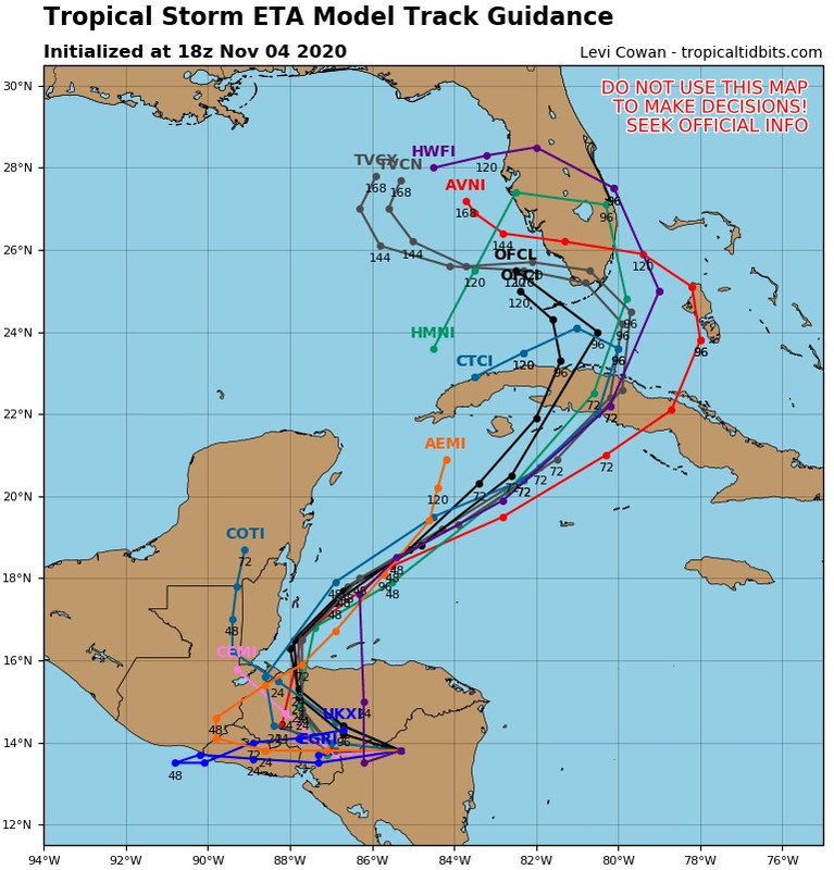
https://www.tropicaltidbits.com/stormin ... latest.png
00z Guidance... Talk about a collapse from 18z... Maybe Eta after CA wasn’t meant to be???
00z Guidance... Talk about a collapse from 18z... Maybe Eta after CA wasn’t meant to be???
0 likes
Hurricane Eye Experience: David 79, Irene 99, Frances 04, Jeanne 04, Wilma 05… Hurricane Brush Experience: Andrew 92, Erin 95, Floyd 99, Matthew 16, Irma 17, Ian 22, Nicole 22…
-
SFLcane

- S2K Supporter
- Posts: 10281
- Age: 48
- Joined: Sat Jun 05, 2010 1:44 pm
- Location: Lake Worth Florida
Re: ATL: ETA - Models
Blown Away wrote:https://www.tropicaltidbits.com/storminfo/29L_tracks_latest.png
00z Guidance... Talk about a collapse from 18z... Maybe Eta after CA wasn’t meant to be???
What in the world? Na something is not right there
0 likes
-
SFLcane
- S2K Supporter
- Posts: 10281
- Age: 48
- Joined: Sat Jun 05, 2010 1:44 pm
- Location: Lake Worth Florida
Re: ATL: ETA - Models
Gfs and the 18z euro still develop this and take it towards Florida. Not sure what took place on the 00z guidance

0 likes

Re: ATL: ETA - Models
SFLcane wrote:Gfs and the 18z euro still develop this and take it towards Florida. Not sure what took place on the 00z guidance
HMON as well... only model I saw drop it was the HWRF... what are we missing?
0 likes
Who is online
Users browsing this forum: Google Adsense [Bot] and 7 guests