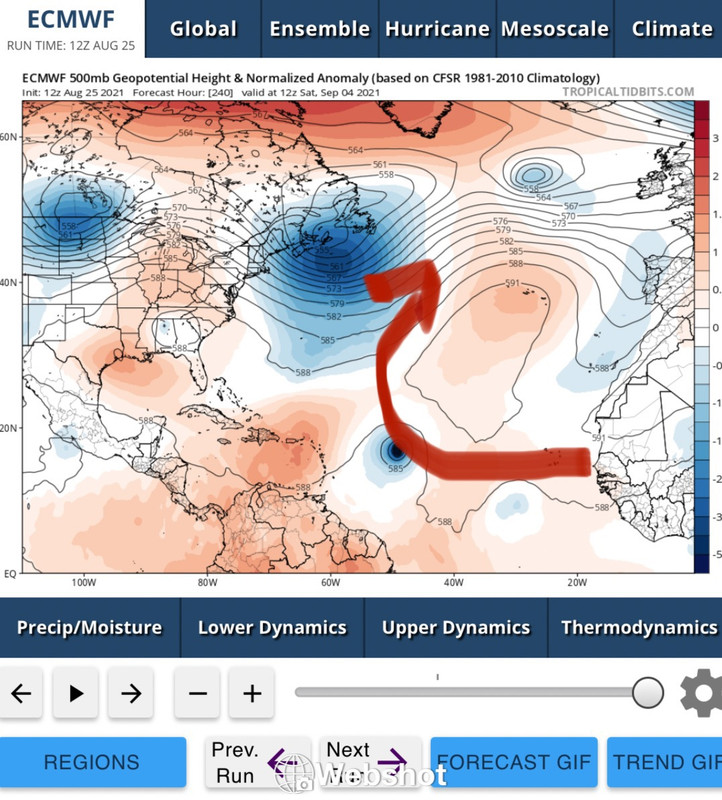
2021 Global Model Runs Discussion (Out thru day 16)

This is the general tropical discussion area. Anyone can take their shot at predicting a storms path.

Moderator: S2k Moderators

Forum rules

The posts in this forum are NOT official forecasts and should not be used as such. They are just the opinion of the poster and may or may not be backed by sound meteorological data. They are NOT endorsed by any professional institution or STORM2K. For official information, please refer to products from the National Hurricane Center and National Weather Service.

Help Support Storm2K
Message
Author
User avatar
chaser1
S2K Supporter
S2K Supporter
Posts: 5464
Age: 64
Joined: Sat Oct 15, 2005 5:59 pm
Location: Longwood, Fl

Re: 2021 Global Model Runs Discussion (Out thru day 16)

#1061 Postby chaser1 » Wed Aug 25, 2021 2:59 pm

Shell Mound wrote:
caneseddy wrote:Looks like at 216 hours on the Euro ridge is starting to fill back in…

The mid-to-upper-air pattern on the run still favours OTS, given high-latitude blocking and progressive shortwaves pirouetting. The TC turns at the very end.


If that set-up were static then yes out to sea would be a reasonable conclusion. On the other hand, one could make the case for that CONUS ridge expanding eastward and being bridged by the westward building W Atlantic mid level heights. I'm pretty sure that neither one of us are that adept at forecasting those subtleties 10 days + out. Even at a 7 day range I feel safer deferring to overall recent pattern persistence then model forecast reliability. Given the broadly stubborn ridging over the Canadian maritimes extending south over the Eastern Seaboard into the W Atlantic, I'd guess this system could pose a potential risk to the Carolina's.
1 likes   
Andy D

(For official information, please refer to the NHC and NWS products.)

jlauderdal
S2K Supporter
S2K Supporter
Posts: 7182
Joined: Wed May 19, 2004 5:46 am
Location: NE Fort Lauderdale
Contact:

Re: RE: Re: 2021 Global Model Runs Discussion (Out thru day 16)

#1062 Postby jlauderdal » Wed Aug 25, 2021 3:38 pm

SFLcane wrote:There’s just nothing to keep this potential system from continuing past 50w. Can it change sure but euro has been
Persistent.

Image
Wide open escape route
3 likes   

User avatar
Teban54
Category 5
Category 5
Posts: 3204
Joined: Sat May 19, 2018 1:19 pm

Re: 2021 Global Model Runs Discussion (Out thru day 16)

#1063 Postby Teban54 » Wed Aug 25, 2021 4:18 pm

Feels like the discussions now are essentially the same as early discussions on the wave that became Irma.

And really, it seems that in recent years there have been too many cases of people calling for a storm to go OTS (even writing long paragraphs on that), only for their predictions to be completely wrong. This happened to at least Irma, Florence, Laura, Fred, and Grace (which ended up in Mexico lol). The opposite happens a lot less frequently in recent years: I can only recall Teddy, and possibly Dorian (which wasn't a true OTS either).

Not saying this won't go OTS, but this is not a time to say that's the only outcome.
4 likes   

User avatar
aspen
Category 5
Category 5
Posts: 8818
Joined: Sat Oct 12, 2019 7:10 pm
Location: Connecticut, USA

Re: 2021 Global Model Runs Discussion (Out thru day 16)

#1064 Postby aspen » Wed Aug 25, 2021 4:35 pm

It’s not every day you see the Euro blow something up into a major, especially in the Atlantic. This looks to be a close call recurve, between Jose and Teddy.
3 likes   
Irene '11 Sandy '12 Hermine '16 5/15/2018 Derecho Fay '20 Isaias '20 Elsa '21 Henri '21 Ida '21

I am only a meteorology enthusiast who knows a decent amount about tropical cyclones. Look to the professional mets, the NHC, or your local weather office for the best information.

emeraldislenc
Category 2
Category 2
Posts: 559
Joined: Fri Aug 24, 2012 4:49 pm
Location: Emerald Isle NC

Re: 2021 Global Model Runs Discussion (Out thru day 16)

#1065 Postby emeraldislenc » Wed Aug 25, 2021 4:40 pm

To be honest this is one reason I do not use storm 2 k like I use too. So many people say OTS or dry air or talk about the " shredder" with every storm. The site is not just as interesting to me like it used to be. Maybe I am being to honest.
0 likes   

User avatar
Spacecoast
Category 2
Category 2
Posts: 758
Joined: Thu Aug 31, 2017 2:03 pm

Re: 2021 Global Model Runs Discussion (Out thru day 16)

#1066 Postby Spacecoast » Wed Aug 25, 2021 5:17 pm

Image
0 likes   

tolakram
Admin
Admin
Posts: 20009
Age: 62
Joined: Sun Aug 27, 2006 8:23 pm
Location: Florence, KY (name is Mark)

Re: 2021 Global Model Runs Discussion (Out thru day 16)

#1067 Postby tolakram » Wed Aug 25, 2021 5:20 pm

emeraldislenc wrote:To be honest this is one reason I do not use storm 2 k like I use too. So many people say OTS or dry air or talk about the " shredder" with every storm. The site is not just as interesting to me like it used to be. Maybe I am being to honest.


Honesty is good, but intolerance to other opinions is not. The only solution is for us to ban everyone that annoys you. If you have a problem with a post then report it, especially if you think it violates S2K rules, otherwise I can't really suggest any improvements.
0 likes   
M a r k
- - - - -
Join us in chat: Storm2K Chatroom Invite. Android and IOS apps also available.

The posts in this forum are NOT official forecasts and should not be used as such. Posts are NOT endorsed by any professional institution or STORM2K.org. For official information and forecasts, please refer to NHC and NWS products.

User avatar
SFLcane
S2K Supporter
S2K Supporter
Posts: 10163
Age: 47
Joined: Sat Jun 05, 2010 1:44 pm
Location: Lake Worth Florida

Re: 2021 Global Model Runs Discussion (Out thru day 16)

#1068 Postby SFLcane » Wed Aug 25, 2021 5:53 pm

Invisible wall at 50w this season it appears. Good news for the islands if things to change.
1 likes   

User avatar
aspen
Category 5
Category 5
Posts: 8818
Joined: Sat Oct 12, 2019 7:10 pm
Location: Connecticut, USA

Re: 2021 Global Model Runs Discussion (Out thru day 16)

#1069 Postby aspen » Wed Aug 25, 2021 6:08 pm

SFLcane wrote:Invisible wall at 50w this season it appears. Good news for the islands if things to change.

Looks like a trough coming off of the east coast breaks down the western part of the ridge and gives the 8/30 wave an escape route.

I agree that some kind of recurve is probable, but it’s too early to tell where it’ll try to recurve. Could be 40W and be completely harmless, could be 60-65W and give the islands a huge scare like Jose.
0 likes   
Irene '11 Sandy '12 Hermine '16 5/15/2018 Derecho Fay '20 Isaias '20 Elsa '21 Henri '21 Ida '21

I am only a meteorology enthusiast who knows a decent amount about tropical cyclones. Look to the professional mets, the NHC, or your local weather office for the best information.

User avatar
Stormybajan
Category 1
Category 1
Posts: 448
Joined: Thu May 20, 2021 3:21 pm
Location: Windward Islands

Re: 2021 Global Model Runs Discussion (Out thru day 16)

#1070 Postby Stormybajan » Wed Aug 25, 2021 6:17 pm

Image
Anyone ready for 99L 2.0? :double:
EDIT: This peaks at 942 mb closing in on landfall...thankfully this is totally in fanatasy land
Last edited by Stormybajan on Wed Aug 25, 2021 6:29 pm, edited 1 time in total.
2 likes   
Sad West Indies and Manchester United fan ⚽️

User avatar
toad strangler
S2K Supporter
S2K Supporter
Posts: 4543
Joined: Sun Jul 28, 2013 3:09 pm
Location: Earth
Contact:

Re: 2021 Global Model Runs Discussion (Out thru day 16)

#1071 Postby toad strangler » Wed Aug 25, 2021 6:24 pm

SFLcane wrote:Invisible wall at 50w this season it appears. Good news for the islands if things to change.


Time to pack it in?

:sun:
3 likes   

User avatar
Hammy
Category 5
Category 5
Posts: 5849
Age: 41
Joined: Fri May 25, 2012 5:25 pm
Contact:

Re: 2021 Global Model Runs Discussion (Out thru day 16)

#1072 Postby Hammy » Wed Aug 25, 2021 6:47 pm

Teban54 wrote:Feels like the discussions now are essentially the same as early discussions on the wave that became Irma.

And really, it seems that in recent years there have been too many cases of people calling for a storm to go OTS (even writing long paragraphs on that), only for their predictions to be completely wrong. This happened to at least Irma, Florence, Laura, Fred, and Grace (which ended up in Mexico lol). The opposite happens a lot less frequently in recent years: I can only recall Teddy, and possibly Dorian (which wasn't a true OTS either).

Not saying this won't go OTS, but this is not a time to say that's the only outcome.


I have to agree with this, I've seen too many times when watching winter weather that the models seem to overdo the strength of the troughs. Too often both with during winter and summer alike, they end up weaker and farther north or west as the timeframe gets closer.
3 likes   
The above post is not official and should not be used as such. It is the opinion of the poster and may or may not be backed by sound meteorological data. It is not endorsed by any professional institution or storm2k.org. For official information, please refer to the NHC and NWS products.

User avatar
SFLcane
S2K Supporter
S2K Supporter
Posts: 10163
Age: 47
Joined: Sat Jun 05, 2010 1:44 pm
Location: Lake Worth Florida

Re: 2021 Global Model Runs Discussion (Out thru day 16)

#1073 Postby SFLcane » Wed Aug 25, 2021 7:32 pm

toad strangler wrote:
SFLcane wrote:Invisible wall at 50w this season it appears. Good news for the islands if things to change.


Time to pack it in?

:sun:


October should be fun. :wink:
3 likes   

jlauderdal
S2K Supporter
S2K Supporter
Posts: 7182
Joined: Wed May 19, 2004 5:46 am
Location: NE Fort Lauderdale
Contact:

Re: RE: Re: 2021 Global Model Runs Discussion (Out thru day 16)

#1074 Postby jlauderdal » Wed Aug 25, 2021 7:37 pm

emeraldislenc wrote:To be honest this is one reason I do not use storm 2 k like I use too. So many people say OTS or dry air or talk about the " shredder" with every storm. The site is not just as interesting to me like it used to be. Maybe I am being to honest.
Its a discussion board...we discuss various scenarios...always refer to the nhc for the best track forecast
4 likes   

User avatar
chaser1
S2K Supporter
S2K Supporter
Posts: 5464
Age: 64
Joined: Sat Oct 15, 2005 5:59 pm
Location: Longwood, Fl

Re: RE: Re: 2021 Global Model Runs Discussion (Out thru day 16)

#1075 Postby chaser1 » Wed Aug 25, 2021 11:33 pm

jlauderdal wrote:
emeraldislenc wrote:To be honest this is one reason I do not use storm 2 k like I use too. So many people say OTS or dry air or talk about the " shredder" with every storm. The site is not just as interesting to me like it used to be. Maybe I am being to honest.
Its a discussion board...we discuss various scenarios...always refer to the nhc for the best track forecast


However......... because this IS a discussion board, one need always "consider the source" as well. Any bobble-head can blurt out an opinion. If you take the time, you'll come to recognize some posters here to be less flippant and a bit more grounded in their analysis.
4 likes   
Andy D

(For official information, please refer to the NHC and NWS products.)

User avatar
ElectricStorm
Category 5
Category 5
Posts: 5044
Age: 24
Joined: Tue Aug 13, 2019 11:23 pm
Location: Skiatook, OK / Norman, OK

Re: 2021 Global Model Runs Discussion (Out thru day 16)

#1076 Postby ElectricStorm » Wed Aug 25, 2021 11:47 pm

0z GFS has another gulf storm behind 99L. It's also picking up on some MDR storms
0 likes   
B.S Meteorology, University of Oklahoma '25

Please refer to the NHC, NWS, or SPC for official information.

psyclone
S2K Supporter
S2K Supporter
Posts: 4762
Joined: Wed Aug 24, 2005 9:04 pm
Location: palm harbor fl

Re: 2021 Global Model Runs Discussion (Out thru day 16)

#1077 Postby psyclone » Wed Aug 25, 2021 11:47 pm

emeraldislenc wrote:To be honest this is one reason I do not use storm 2 k like I use too. So many people say OTS or dry air or talk about the " shredder" with every storm. The site is not just as interesting to me like it used to be. Maybe I am being to honest.


You should participate more and influence the trajectory of the discourse. It is fair to say we've had a good bit of shredder talk thus far but that's because we've had lots of shredder interactions. Now that we're in peak season things are going to be more interesting than ever....especially when you live in a region as hurricane prone as yours. All the best up your way this year :D
2 likes   

Shell Mound
Category 5
Category 5
Posts: 2434
Age: 32
Joined: Thu Sep 07, 2017 3:39 pm
Location: St. Petersburg, FL → Scandinavia

Re: 2021 Global Model Runs Discussion (Out thru day 16)

#1078 Postby Shell Mound » Thu Aug 26, 2021 12:00 am

Teban54 wrote:Feels like the discussions now are essentially the same as early discussions on the wave that became Irma.

And really, it seems that in recent years there have been too many cases of people calling for a storm to go OTS (even writing long paragraphs on that), only for their predictions to be completely wrong. This happened to at least Irma, Florence, Laura, Fred, and Grace (which ended up in Mexico lol). The opposite happens a lot less frequently in recent years: I can only recall Teddy, and possibly Dorian (which wasn't a true OTS either).

Not saying this won't go OTS, but this is not a time to say that's the only outcome.

The difference is that this time the major global models concur unusually strongly that the upcoming pattern will favour weak subtropical ridging and frequent troughs. Moreover, the major suites, especially the EPS, have been very persistent in highlighting high-latitude blocking and weaknesses underneath. The EPS is normally conservative, yet it has consistently suggested a potent system forming close to West Africa. Taken together, the evidence strongly suggests that the potential system would curve OTS quickly, with any ridging proving to ephemeral and/or thin, which would be insufficient to deflect a strong system westward at any point, much less for a sustained period of time. So far I suspect that anything that develops will curve east of the Islands and Bermuda. Models would need to show a drastically different high-latitude situation in order for the outcome to change.
Last edited by Shell Mound on Thu Aug 26, 2021 12:03 am, edited 1 time in total.
0 likes   
CVW / MiamiensisWx / Shell Mound
The posts in this forum are NOT official forecasts and should not be used as such. They are just the opinion of the poster and may or may not be backed by sound meteorological data. They are NOT endorsed by any professional institution or STORM2K. For official information, please refer to products from the NHC and NWS.

User avatar
SouthFLTropics
Category 5
Category 5
Posts: 4236
Age: 50
Joined: Thu Aug 14, 2003 8:04 am
Location: Port St. Lucie, Florida

Re: 2021 Global Model Runs Discussion (Out thru day 16)

#1079 Postby SouthFLTropics » Thu Aug 26, 2021 12:02 am

Don’t speak too soon. Late in this GFS run it looks like the ridge may build back in. Of course this is out in lala land but I don’t think an OTS track is guaranteed with anything just yet.


Sent from my iPhone using Tapatalk
0 likes   
Fourth Generation Florida Native

Personal Storm History: David 79, Andrew 92, Erin 95, Floyd 99, Irene 99, Frances 04, Jeanne 04, Wilma 05, Matthew 16, Irma 17, Ian 22, Nicole 22, Milton 24

Keldeo1997
Category 2
Category 2
Posts: 637
Joined: Fri Oct 11, 2019 11:35 pm

Re: 2021 Global Model Runs Discussion (Out thru day 16)

#1080 Postby Keldeo1997 » Thu Aug 26, 2021 12:48 am

 https://twitter.com/DerekOrtt/status/1430755759147700224


Unfortunately we might be looking at round 2
0 likes   


Return to “Talkin' Tropics”

Who is online

Users browsing this forum: No registered users and 37 guests