They just showed live footage from Galveston island and they are getting pounded pretty good right now! Looked like they were getting minimal tropical storm force winds (likely near 35-40mph with higher gusts) at the waterfront. Officially at Scholes field though, winds are a bit lighter..currently near 31mph sustained with gusts to 43mph.
Up here in Houston, however, you probably would not know there was a tropical storm unless you watched the news or came on storm2k. All we are seeing is a comfortable northeast breeze (less than 25mph), some fast moving clouds, and the occassional spit of mist.
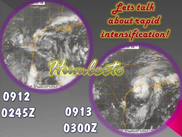
Tropical Depression HUMBERTO Discussion & Images
Moderator: S2k Moderators
-
Extremeweatherguy

- Category 5

- Posts: 11095
- Joined: Mon Oct 10, 2005 8:13 pm
- Location: Florida
-
Sean in New Orleans

- Category 5
- Posts: 1794
- Joined: Thu Aug 28, 2003 7:26 pm
- Location: New Orleans, LA 30.0N 90.0W
- Contact:
Well, fear not...the possibility is there that the storm could loop back down to the Gulf is very possible. Heck the center could swing back down and go directly over Baton Rouge, New Orleans, or the MS Gulf Coast. The future of the system is actually more interesting than this landfall. A loop is or several over land is very possible. Stay tuned....
0 likes
-
HouTXmetro

- Category 5
- Posts: 3949
- Joined: Sun Jun 13, 2004 6:00 pm
- Location: District of Columbia, USA
-
Category 5

- Category 5
- Posts: 10074
- Age: 35
- Joined: Sun Feb 11, 2007 10:00 pm
- Location: New Brunswick, NJ
- Contact:
Re: Re:
Stormcenter wrote:Category 5 wrote:HouTXmetro wrote:Call me crazy but the radar loop shows a N/NNW jump.
You're not crazy, I see it too.
What are you guys seeing? I mean I'm trying to agree with you all who see this
NW jog and it's just not there. It's still NNE as it has been for a good while now.
http://radar.weather.gov/radar.php?prod ... H&loop=yes
Nothing actually, the eyewall rewrapping sort of gave the illusion.
0 likes
-
CrazyC83
- Professional-Met

- Posts: 34310
- Joined: Tue Mar 07, 2006 11:57 pm
- Location: Deep South, for the first time!
Re:
Buck wrote:What are other storms that pulled it just into Hurricane strength right on the coast before landfall?
Erika (2003)
Gaston (2004)
Cindy (2005)
The TCR said Ernesto last year might have made it to hurricane strength at landfall; poor sampling prevented them from making the move up as it was inconclusive.
Last edited by CrazyC83 on Wed Sep 12, 2007 10:11 pm, edited 1 time in total.
0 likes
-
Andrew92

- S2K Supporter

- Posts: 3247
- Age: 42
- Joined: Mon Jun 16, 2003 12:35 am
- Location: Phoenix, Arizona
Some other ancient storms have done what Humberto is trying to do, not just the recent storms such as Erika, Gaston, and Cindy.
In 1959, Debra stalled just off the coast and ramped up quickly into a hurricane before making landfall. She spent a little more time over water, but she still had to hurry to develop into a hurricane, and she did.
http://www.weather.unisys.com/hurricane ... /track.gif
In 1963, another Cindy developed not far from where Humberto did, and likely had very long odds of becoming a hurricane. Yet, she did become one and caused some flooding problems.
http://www.weather.unisys.com/hurricane ... /track.gif
Will Humberto follow suit in the next couple hours? We shall see!
-Andrew92
0 likes
-
jasons2k

- Storm2k Executive

- Posts: 8284
- Age: 52
- Joined: Wed Jul 06, 2005 12:32 pm
- Location: The Woodlands, TX
Re: T.S.HUMBERTO (GOM): Discussion & Images:10 PM CDT page 44
mattpetre wrote:I was bullish on this storm from day 1 (last Thursday) and I tried to give kudos to those that were and was told it was nothing significant, just September in the Tropics (anything can happen.) Then I state that I still believe a SLIGHT NW turn is possible before landfall and Galveston (and I mean the city) could still be in the center and I'm told that is completely impossible... come on now... I thought it was September in the tropics... I saw this storm being a threat from Corpus to the LA/TX for the last 6 days and yet I'm the one now that only sees things that are impossible?? I give up...
I think the issue is that you have been consistently saying all day that this would go NW when it's been quite apparent all day that it wouldn't. Especially at this late hour it's crystal clear that LF in Galveston is out of the question.
0 likes

-
GalvestonDuck
- Category 5
- Posts: 15941
- Age: 57
- Joined: Fri Oct 11, 2002 8:11 am
- Location: Galveston, oh Galveston (And yeah, it's a barrier island. Wanna make something of it?)
Re: T.S.HUMBERTO (GOM): Discussion & Images:10 PM CDT page 44
Actually, Galveston's east end is not west of the center...yet. I'm on the east end. If I stood outside and looked east, I wouldn't be facing the center of the storm. It is still SSE of us.
And as for Bolivar being part of Galveston...it's not. Bolivar Peninsula is a whole other body of land, not associated with Galveston Island. It is located across the entrance to the bay. It is, however, part of Galveston county. But then again, so is Texas City, Lamarque, Bayou Vista, Tiki Island, Santa Fe, and a host of other cities and towns that aren't on Galveston Island.
It's windy here, but we're not getting pounded.
0 likes
-
Bailey1777
- S2K Supporter
- Posts: 962
- Joined: Mon Jul 31, 2006 6:23 pm
- Location: Houston, Texas
-
mattpetre
- Category 2

- Posts: 510
- Age: 54
- Joined: Mon Sep 19, 2005 3:20 pm
- Location: Missouri City,TX & Galleria
- Contact:
Re: T.S.HUMBERTO (GOM): Discussion & Images:10 PM CDT page 44
I apologize for the tone of my last post (almost whining) and would just like to add the following.
It does appear that Houston Metro will be spared from this storm (at least as long as it does not loop back into the gulf and come this way) and it does appear that landfall will be east of Galveston. I do think there is still some chance of a minimal hurricane from this and I am proud that I stuck by 90L (along with Stormcenter and a few others) through its invest to non-invest to back to invest status the past few days. I think it just starts to wear on one to keep watching and trying to make predictions or forecasts and at the same time to realize that I just don't have the overall knowledge of many on here.... No more whining just explaining why I'm a little tired. I'm just glad it looks like the millions in Houston will be safe through this event and hope that no one in E TX or SWLA are unprepared for a minimal hurricane possibility.
It does appear that Houston Metro will be spared from this storm (at least as long as it does not loop back into the gulf and come this way) and it does appear that landfall will be east of Galveston. I do think there is still some chance of a minimal hurricane from this and I am proud that I stuck by 90L (along with Stormcenter and a few others) through its invest to non-invest to back to invest status the past few days. I think it just starts to wear on one to keep watching and trying to make predictions or forecasts and at the same time to realize that I just don't have the overall knowledge of many on here.... No more whining just explaining why I'm a little tired. I'm just glad it looks like the millions in Houston will be safe through this event and hope that no one in E TX or SWLA are unprepared for a minimal hurricane possibility.
0 likes
-
mattpetre
- Category 2
- Posts: 510
- Age: 54
- Joined: Mon Sep 19, 2005 3:20 pm
- Location: Missouri City,TX & Galleria
- Contact:
Re: T.S.HUMBERTO (GOM): Discussion & Images:10 PM CDT page 44
jschlitz wrote:mattpetre wrote:I was bullish on this storm from day 1 (last Thursday) and I tried to give kudos to those that were and was told it was nothing significant, just September in the Tropics (anything can happen.) Then I state that I still believe a SLIGHT NW turn is possible before landfall and Galveston (and I mean the city) could still be in the center and I'm told that is completely impossible... come on now... I thought it was September in the tropics... I saw this storm being a threat from Corpus to the LA/TX for the last 6 days and yet I'm the one now that only sees things that are impossible?? I give up...
I think the issue is that you have been consistently saying all day that this would go NW when it's been quite apparent all day that it wouldn't. Especially at this late hour it's crystal clear that LF in Galveston is out of the question.
However, for much of that time I was just following what seemed apparent in the CIMSS steering products... and it was quite apparent to me 5 days ago that this would be at least a depression, but I did not tell those that said otherwise they were crazy. (a little tongue in cheek, but i did stick to my guns on this and always will... not a Bill Clinton on the Storms)
Last edited by mattpetre on Wed Sep 12, 2007 10:20 pm, edited 1 time in total.
0 likes
-
srainhoutx

- S2K Supporter
- Posts: 6919
- Age: 68
- Joined: Sun Jan 14, 2007 11:34 am
- Location: Haywood County, NC
- Contact:
Re: T.S.HUMBERTO (GOM): Discussion & Images:10 PM CDT page 44
Just a reminder. We have been tracking this disturbance since the 6th. With a true Tropical System we have a LLC that will persist even after landfall. The history of Humberto/90L suggest a DMIN every evening until around midnight - 2 AM. Remember we went to bed last night with a INVEST 90L and tonight a 65 mph Tropical Storm.
http://www.ssd.noaa.gov/goes/flt/t1/loop-ir2.html
http://www.ssd.noaa.gov/goes/flt/t1/loop-ir2.html
0 likes
-
tolakram
- Admin
- Posts: 20170
- Age: 62
- Joined: Sun Aug 27, 2006 8:23 pm
- Location: Florence, KY (name is Mark)
Re: T.S.HUMBERTO (GOM): Discussion & Images:10 PM CDT page 44
http://www.ssd.noaa.gov/goes/flt/t1/loop-avn.html
Look how it lost nearly all deep convection and then re-fired. I don't think we've seen the end of intensification yet, unless I totally am misreading the infrared images.
Look how it lost nearly all deep convection and then re-fired. I don't think we've seen the end of intensification yet, unless I totally am misreading the infrared images.
0 likes
-
mattpetre
- Category 2
- Posts: 510
- Age: 54
- Joined: Mon Sep 19, 2005 3:20 pm
- Location: Missouri City,TX & Galleria
- Contact:
Re: T.S.HUMBERTO (GOM): Discussion & Images:10 PM CDT page 44
srainhoutx wrote:Just a reminder. We have been tracking this disturbance since the 6th. With a true Tropical System we have a LLC that will persist even after landfall. The history of Humberto/90L suggest a DMIN every evening until around midnight - 2 AM. Remember we went to bed last night with a INVEST 90L and tonight a 65 mph Tropical Storm.
http://www.ssd.noaa.gov/goes/flt/t1/loop-ir2.html
Very true and it does tend to "wake up" around 4 or 5 in the morning especially... perhaps it will be onshore by then.
0 likes
-
PTrackerLA

- Category 5
- Posts: 5281
- Age: 42
- Joined: Thu Oct 10, 2002 8:40 pm
- Location: Lafayette, LA
Re: T.S.HUMBERTO (GOM): Discussion & Images:10 PM CDT page 44
Looks like Humberto just got a kick to the NE. The center has also become more ragged so I don't think this will be making it to hurricane force at this time.
Side note: This is one of the tiniest systems I've seen. Northern GOM homegrowns are typically small (i.e. Danny) but the central core of this is downright midget-like!
Side note: This is one of the tiniest systems I've seen. Northern GOM homegrowns are typically small (i.e. Danny) but the central core of this is downright midget-like!
Last edited by PTrackerLA on Wed Sep 12, 2007 10:28 pm, edited 1 time in total.
0 likes
-
Andrew92
- S2K Supporter
- Posts: 3247
- Age: 42
- Joined: Mon Jun 16, 2003 12:35 am
- Location: Phoenix, Arizona
I'm no expect on the diurnal maxima and minima, but if what you guys are posting is true, I would say that Humberto survived this D-MIN with flying colors. And if it still might have 7 hours before landfall (down now from 7.5 since I said that when the advisory came out, which was a half-hour ago), this thing could still very well intensify more before landfall.
MAN are the Upper Texas and Louisiana coasts lucky that it only developed today! I cringe over what might have been had it developed yesterday. Stay safe you guys, prayers will be sent to all of you going through this storm!
-Andrew92
MAN are the Upper Texas and Louisiana coasts lucky that it only developed today! I cringe over what might have been had it developed yesterday.
-Andrew92
0 likes
-
Sean in New Orleans
- Category 5
- Posts: 1794
- Joined: Thu Aug 28, 2003 7:26 pm
- Location: New Orleans, LA 30.0N 90.0W
- Contact:
This is a pretty fierce outer band S. of Lake Charles. No doubt there are quite a few waterspouts over the Gulf in this band. http://www.srh.noaa.gov/ridge/radar.php ... h&loop=yes
0 likes
Who is online
Users browsing this forum: No registered users and 32 guests