ATL: IKE Discussion
Moderator: S2k Moderators
-
giantshark18
- Tropical Wave

- Posts: 1
- Joined: Thu Sep 11, 2008 12:36 pm
Re:
CowboyFan wrote:looks like the famous "fist"----could be about to get stronger
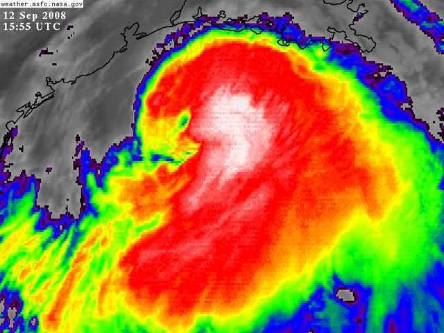
I have seen the "Fist" reference a couple of times. What does it mean?
0 likes


Re: ATL IKE: Category 2 - Discussion
dixiebreeze wrote:OMG! Look at all those black tops:
http://www.ssd.noaa.gov/goes/flt/t3/loop-avn.html
What do the black tops mean? Sorry, I'm very amateur.
Ike looks like a bad a-- for being a Category 1/2. He seems worse than some that have been above that (3).
0 likes
-
cycloneye

- Admin

- Posts: 149387
- Age: 69
- Joined: Thu Oct 10, 2002 10:54 am
- Location: San Juan, Puerto Rico
Re: ATL IKE: Category 2 - Discussion
Well the next set even more higher 123 kts at Flight Level. 
0 likes
Re:
bayoubebe wrote:Question for Louisiana. Are we expected to get any of the bad cells that are RIGHT below us in the gulf? I've been searching for that answer online and t.v.; can't find anything right now.
Those bands look so close to us, but it appears they are moving west. Will they move north?
I'm wondering the same thing.
0 likes

-
DESTRUCTION5

- Category 5

- Posts: 4430
- Age: 44
- Joined: Wed Sep 03, 2003 11:25 am
- Location: Stuart, FL
Re:
CrazyC83 wrote:123 kt FL winds by the NOAA plane - supports 105 kt at the surface, although the SFMR is much lower (86 kt).
Shall i be the 1st to say CAT3 at 2?
0 likes
-
JtSmarts

- S2K Supporter

- Posts: 1442
- Age: 40
- Joined: Thu Jul 10, 2003 1:29 pm
- Location: Columbia, South Carolina
Re: ATL IKE: Category 2 - Discussion
cycloneye wrote:Well the next set even more higher 123 kts at Flight Level.
We are close to Cat 3. Not sure about the reduction but 80% is 98.4 kts
0 likes
-
dixiebreeze
- S2K Supporter
- Posts: 5140
- Joined: Wed Sep 03, 2003 5:07 pm
- Location: crystal river, fla.
Re: ATL IKE: Category 2 - Discussion
bayoubebe wrote:dixiebreeze wrote:OMG! Look at all those black tops:
http://www.ssd.noaa.gov/goes/flt/t3/loop-avn.html
What do the black tops mean? Sorry, I'm very amateur.
Ike looks like a bad a-- for being a Category 1/2. He seems worse than some that have been above that (3).
Intensity!
0 likes
-
CrazyC83
- Professional-Met

- Posts: 34315
- Joined: Tue Mar 07, 2006 11:57 pm
- Location: Deep South, for the first time!
Re: Re:
DESTRUCTION5 wrote:CrazyC83 wrote:123 kt FL winds by the NOAA plane - supports 105 kt at the surface, although the SFMR is much lower (86 kt).
Shall i be the 1st to say CAT3 at 2?
I wouldn't go there since the data is not supported by dropsondes or SFMR, although with the surface estimate earlier, I would say 95 kt.
0 likes

Re: Re:
giantshark18 wrote:CowboyFan wrote:looks like the famous "fist"----could be about to get stronger
I have seen the "Fist" reference a couple of times. What does it mean?
can this be confirmed by anyone who understand the "fist" phenomena, i have heard it talked about and then seen it verified but does the recent convection = "the fist" or No?
0 likes
Re: Re:
from nhc:
THERE IS STILL A CHANCE THAT IT COULD BECOME A MAJOR HURRICANE BEFORE
LANDFALL...BUT BASICALLY THIS IS IRRELEVANT SINCE WE ARE ONLY
TALKING ABOUT A 10-KNOT INCREASE.
THERE IS STILL A CHANCE THAT IT COULD BECOME A MAJOR HURRICANE BEFORE
LANDFALL...BUT BASICALLY THIS IS IRRELEVANT SINCE WE ARE ONLY
TALKING ABOUT A 10-KNOT INCREASE.
DESTRUCTION5 wrote:CrazyC83 wrote:123 kt FL winds by the NOAA plane - supports 105 kt at the surface, although the SFMR is much lower (86 kt).
Shall i be the 1st to say CAT3 at 2?
0 likes
Re: Re:
giantshark18 wrote:CowboyFan wrote:looks like the famous "fist"----could be about to get stronger
I have seen the "Fist" reference a couple of times. What does it mean?
It's the shape of the cloud mass around the center, in the past it sometimes was the start of a strenghtening phase
0 likes
-
pablolopez26
- Tropical Storm

- Posts: 137
- Joined: Wed Aug 27, 2008 5:10 pm
-
dixiebreeze
- S2K Supporter
- Posts: 5140
- Joined: Wed Sep 03, 2003 5:07 pm
- Location: crystal river, fla.
Re: Re:
AMeyerRN wrote:bayoubebe wrote:Question for Louisiana. Are we expected to get any of the bad cells that are RIGHT below us in the gulf? I've been searching for that answer online and t.v.; can't find anything right now.
Those bands look so close to us, but it appears they are moving west. Will they move north?
I'm wondering the same thing.
Regardless, Louisiana will be inundated.
0 likes
-
Cryomaniac
- Category 5
- Posts: 1289
- Joined: Tue Aug 15, 2006 2:26 pm
- Location: Newark, Nottinghamshire, UK
- Contact:
Re:
KWT wrote:123kts at flight level is going to get this major status, seemns like the explosive convection has finally tiped Ike over the edge.
I think so too. This has still got time to intensify quite a lot.
0 likes
Who is online
Users browsing this forum: No registered users and 32 guests