
Pressure down to 990.9mb in Tallahassee, tornadic cells about to go through that area.
Conditions at: KTLH observed 22 January 2017 20:02 UTC
Temperature: 24.4°C (76°F)
Dewpoint: 21.1°C (70°F) [RH = 82%]
Pressure (altimeter): 29.26 inches Hg (990.9 mb)
Winds: from the S (190 degrees) at 26 MPH (23 knots; 12.0 m/s)
gusting to 40 MPH (35 knots; 18.2 m/s)
Visibility: 9 miles (14 km)
Ceiling: 1900 feet AGL
Clouds: broken clouds at 1900 feet AGL
overcast cloud deck at 2700 feet AGL
Present Weather: -TSRA (light rain associated with thunderstorm(s))
SOME DATA ABOVE MAY BE INACCURATE!!!
"$" is an indication the sensor requires maintenance
Florida Weather
Moderator: S2k Moderators
Forum rules

The posts in this forum are NOT official forecast and should not be used as such. They are just the opinion of the poster and may or may not be backed by sound meteorological data. They are NOT endorsed by any professional institution or STORM2K.
Re: Florida Weather
0 likes
Re: Florida Weather
impressive TDS with that cell in Franklin county...hopefully it's just blasting trees in rural terrain.
0 likes
-
northjaxpro

- S2K Supporter

- Posts: 8900
- Joined: Mon Sep 27, 2010 11:21 am
- Location: Jacksonville, FL
Re: Florida Weather
That squall line is booking!! Incredible how fast it is moving. The severe weather looks to be here within the next 2 to 3 hours based on the movement of the squall line. Extremely impressive to say is a vast understatement.
0 likes
NEVER, EVER SAY NEVER in the tropics and weather in general, and most importantly, with life itself!!
________________________________________________________________________________________
Fay 2008 Beryl 2012 Debby 2012 Colin 2016 Hermine 2016 Julia 2016 Matthew 2016 Irma 2017 Dorian 2019
________________________________________________________________________________________
Fay 2008 Beryl 2012 Debby 2012 Colin 2016 Hermine 2016 Julia 2016 Matthew 2016 Irma 2017 Dorian 2019
Re: Florida Weather
High risk drawn down the west coast to Sarasota county. I've never been in a high risk designation before.
1 likes
Re: Florida Weather
30% hatched TOR. Based on that upgrade...not only will a watch be forthcoming but it could well be PDS for portions of the area. If there was ever a time to pray for a bust...this is it.
1 likes
Re: Florida Weather
Central florida folks we've got our mesoscale discussion...tornado watch coming soon.
1 likes


Re: Florida Weather
psyclone wrote:Central florida folks we've got our mesoscale discussion...tornado watch coming soon.
Indeed
Graphic here http://www.spc.noaa.gov/products/md/md0120.html
0 likes
-
gatorcane

- S2K Supporter
- Posts: 23708
- Age: 48
- Joined: Sun Mar 13, 2005 3:54 pm
- Location: Boca Raton, FL
Re: Florida Weather
Looks like the squall line is deepening off Clearwater....but moving ENE which would send it just north, Tampa area may just thread the needle indeed.
0 likes
Re: Florida Weather
FWIW the southward extent of the squall line hasn't had much luck building south in the past hour. some little cells trying to pop east of the line. this threat is going to be a quickie for the bay area and nature coast considering the speed of the line
0 likes
-
gatorcane
- S2K Supporter
- Posts: 23708
- Age: 48
- Joined: Sun Mar 13, 2005 3:54 pm
- Location: Boca Raton, FL
Re: Florida Weather
New Tornado watch just issued:
Tornado Watch
TORNADO WATCH OUTLINE UPDATE FOR WT 23
NWS STORM PREDICTION CENTER NORMAN OK
435 PM EST SUN JAN 22 2017
TORNADO WATCH 23 IS IN EFFECT UNTIL 1000 PM EST FOR THE
FOLLOWING LOCATIONS
FLC009-017-027-049-053-055-057-069-081-095-097-101-103-105-115-
117-119-127-230300-
/O.NEW.KWNS.TO.A.0023.170122T2135Z-170123T0300Z/
FL
. FLORIDA COUNTIES INCLUDED ARE
BREVARD CITRUS DESOTO
HARDEE HERNANDO HIGHLANDS
HILLSBOROUGH LAKE MANATEE
ORANGE OSCEOLA PASCO
PINELLAS POLK SARASOTA
SEMINOLE SUMTER VOLUSIA
$$
http://forecast.weather.gov/showsigwx.p ... IUo2Ms8KhA
Last edited by gatorcane on Sun Jan 22, 2017 4:50 pm, edited 1 time in total.
0 likes
-
otowntiger
- Category 5

- Posts: 1932
- Joined: Tue Aug 31, 2004 7:06 pm
-
AdamFirst

- S2K Supporter
- Posts: 2490
- Age: 36
- Joined: Thu Aug 14, 2008 10:54 am
- Location: Port Saint Lucie, FL
Re: Florida Weather
otowntiger wrote:What is 'PDS'??
Particularly Dangerous Situation
1 likes
Dolphins Marlins Canes Golden Panthers HEAT
Andrew 1992 - Irene 1999 - Frances 2004 - Jeanne 2004 - Wilma 2005 - Fay 2008 - Isaac 2012 - Matthew 2016 - Irma 2017 - Dorian 2019 - Ian 2022 - Nicole 2022 - Milton 2024
Andrew 1992 - Irene 1999 - Frances 2004 - Jeanne 2004 - Wilma 2005 - Fay 2008 - Isaac 2012 - Matthew 2016 - Irma 2017 - Dorian 2019 - Ian 2022 - Nicole 2022 - Milton 2024

Re: Florida Weather
Really? So.... a significant risk of strong to severe weather is trumped by a Tornado/Severe Storm Watch.
And now we have a "PDS" which supersedes a Tornado/Severe Storm Watch?? Thus far today the Orlando area has yet to receive any convective impact. No doubt though, it is becoming plainly clear that convective cells are beginning to now develop in earnest , but in a narrow area just east of the very fast approaching squall line. Looks like whatever impact might/will occur with this event,"show time" is about to occur from point Tampa and Northeastward through Central Fla. starting very soon (beginning in Tampa area within the next 30 min.)
And now we have a "PDS" which supersedes a Tornado/Severe Storm Watch?? Thus far today the Orlando area has yet to receive any convective impact. No doubt though, it is becoming plainly clear that convective cells are beginning to now develop in earnest , but in a narrow area just east of the very fast approaching squall line. Looks like whatever impact might/will occur with this event,"show time" is about to occur from point Tampa and Northeastward through Central Fla. starting very soon (beginning in Tampa area within the next 30 min.)
0 likes
Andy D
(For official information, please refer to the NHC and NWS products.)
(For official information, please refer to the NHC and NWS products.)
-
gatorcane
- S2K Supporter
- Posts: 23708
- Age: 48
- Joined: Sun Mar 13, 2005 3:54 pm
- Location: Boca Raton, FL
Re: Florida Weather
Southern part of line getting stronger. Could be some wild weather across the Tampa Bay Area.
0 likes
Re: Florida Weather
Pinellas county looks to have threaded the needle WRT tornadic supercells...we just need to get through the squall line and we'll be cleared soon. BTW 59 mph gust just reported @ the Hernando county airport.
0 likes
Re: Florida Weather
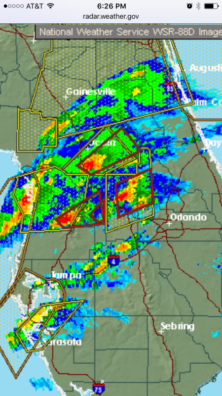
3 tornadic cells NW of the Orlando County in northern Lake, Sumnter...Counties

0 likes
Re: Florida Weather
very impressive couplet crossing 75 near the Sumter Hernando line. there's a rest area right on the Sumter county side of the river that I've stopped at many times. Good chance a tornado just crossed the interstate. this is the long track storm that came ashore north of Tarpon Springs about an hour ago. It's been going nonstop. If it keep going it will enter Lake county in about 20 minutes
0 likes
-
northjaxpro
- S2K Supporter
- Posts: 8900
- Joined: Mon Sep 27, 2010 11:21 am
- Location: Jacksonville, FL
Re: Florida Weather
Squall line right on our doorstep here in the Jax metro area. The line will be moving though wwithin the next 30 minutes. Winds already have gusted to a max of 53 mph here at my locale in cells that came through around 4:00 p.m.
I will keep you all as posted as I can while trying to stay safe.
I will keep you all as posted as I can while trying to stay safe.
1 likes
NEVER, EVER SAY NEVER in the tropics and weather in general, and most importantly, with life itself!!
________________________________________________________________________________________
Fay 2008 Beryl 2012 Debby 2012 Colin 2016 Hermine 2016 Julia 2016 Matthew 2016 Irma 2017 Dorian 2019
________________________________________________________________________________________
Fay 2008 Beryl 2012 Debby 2012 Colin 2016 Hermine 2016 Julia 2016 Matthew 2016 Irma 2017 Dorian 2019
Re: Florida Weather
extreme reflectivity on that long track cell now near Leesburg. that one may rip across the whole peninsula
0 likes
Return to “USA & Caribbean Weather”
Who is online
Users browsing this forum: opticsguy, South Texas Storms and 117 guests