2020 Global Model Runs Discussion (Out thru day 16)

This is the general tropical discussion area. Anyone can take their shot at predicting a storms path.

Moderator: S2k Moderators

Forum rules

The posts in this forum are NOT official forecasts and should not be used as such. They are just the opinion of the poster and may or may not be backed by sound meteorological data. They are NOT endorsed by any professional institution or STORM2K. For official information, please refer to products from the National Hurricane Center and National Weather Service.

Help Support Storm2K
Message
Author
User avatar
Steve
S2K Supporter
S2K Supporter
Posts: 9620
Joined: Sat Apr 05, 2003 11:41 pm
Location: Not a state-caster

Re: 2020 Global Model Runs Discussion (Out thru day 16)

#1181 Postby Steve » Sun Aug 09, 2020 1:44 pm

Here is one more chart you can use to "verify" MJO model vs. actual weather. This chart is described as:

Approximate locations of the MJO centre of convection RMM Index phases 1-8. Phase1 includes signals both from the initiation of an MJO event in the western Indian Ocean basin and the breakdown of MJO events in the mid- Pacific Ocean. During phases 2 through 8 the MJO travels east at 4-10 days/phase.

So you would look to those areas of the Pacific and Indian Oceans to see where the convection is firing off and locate "about the center" of it. Lots of refiring from Indonesia and a bit east toward New Guinea (Phases 4/5 which we have been and are in)

Image

Satellite of the area
https://www.accuweather.com/en/id/jakar ... ite/208971
3 likes   

User avatar
Hurricaneman
Category 5
Category 5
Posts: 7351
Age: 45
Joined: Tue Aug 31, 2004 3:24 pm
Location: central florida

Re: 2020 Global Model Runs Discussion (Out thru day 16)

#1182 Postby Hurricaneman » Sun Aug 09, 2020 8:34 pm

The GFS is probably showing it’s mjo bias and I’m thinking it circles around to phase 2 like the CFS and that would move the activity to the Atlantic, and that would be around the 20th so that’s when I believe the Atlantic will start to come to life but 1 or 2 weaker systems between now and then could be possible
4 likes   

User avatar
Steve
S2K Supporter
S2K Supporter
Posts: 9620
Joined: Sat Apr 05, 2003 11:41 pm
Location: Not a state-caster

Re: 2020 Global Model Runs Discussion (Out thru day 16)

#1183 Postby Steve » Sun Aug 09, 2020 9:27 pm

Hurricaneman wrote:The GFS is probably showing it’s mjo bias and I’m thinking it circles around to phase 2 like the CFS and that would move the activity to the Atlantic, and that would be around the 20th so that’s when I believe the Atlantic will start to come to life but 1 or 2 weaker systems between now and then could be possible


You're probably right about the bias. I'm curious if it's still going to be leaning that heavily on Phase 1 by the end of the week. It wants to move the enhanced areas toward the EPAC and keep them there though it clearly shows a more favorable Atlantic than what it is now.

https://www.cpc.ncep.noaa.gov/products/ ... hi/gfs.gif
0 likes   

CrazyC83
Professional-Met
Professional-Met
Posts: 34002
Joined: Tue Mar 07, 2006 11:57 pm
Location: Deep South, for the first time!

Re: 2020 Global Model Runs Discussion (Out thru day 16)

#1184 Postby CrazyC83 » Mon Aug 10, 2020 1:33 am

Something tells me the lack of aviation flights is absolutely killing us with tropical forecasting this season. The global models have bombed just about every storm this year, while the HMON and HWRF have generally done the best. With 95L, no model even tries to develop it even though conditions look fairly decent.
4 likes   

Chris90
Category 2
Category 2
Posts: 646
Age: 35
Joined: Thu Jun 01, 2017 9:36 pm

Re: 2020 Global Model Runs Discussion (Out thru day 16)

#1185 Postby Chris90 » Mon Aug 10, 2020 2:27 am

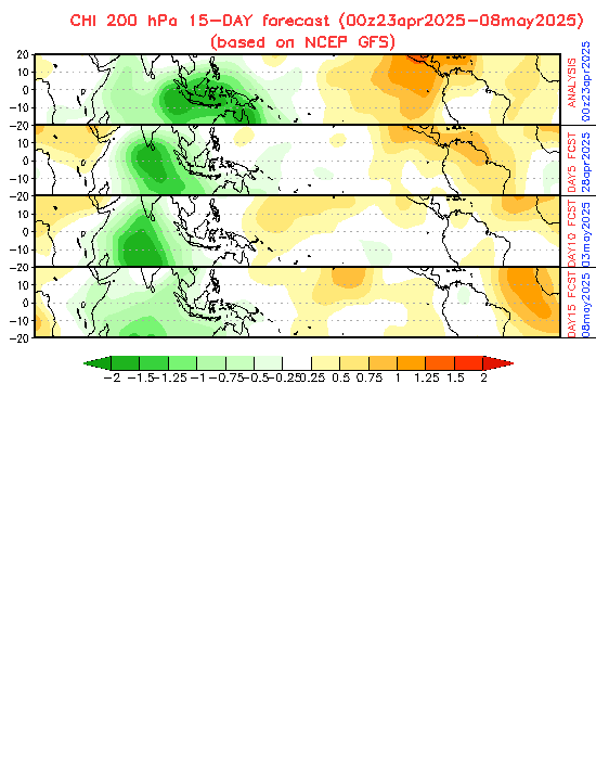
In regards to the MJO and Kelvin Waves, I also like to view it at Tropical Tidbits using the GFS model. If you select the GFS, then select regions, scroll down to the bottom, select world, then select “upper dynamics” then select 200mb CHI anomaly from there. It gives you the world view of favorable VP anomalies and suppressive anomalies. Favorable anomalies are green, there’s 10 shades to show just how amplified they are, and suppressive anomalies are orange/red, with 10 shades also to show level of amplification. I don’t put a whole lot of stock into future forecasts from it, but I like to check the analysis at initialization point usually daily. It’s a good graphic to watch and see what the trends are.

Also, Mark Sudduth has those episodes of “Hurricane U” which are really good, and I think it was the episode from April 8th, but he had Ben Noll on as a guest, and Ben said something like 85% of ATL storms that form during phases 1 or 2 of the MJO become hurricanes. That’s not an exact quote, and the details might be a little off because I’m going from memory, but it was in that ballpark. I can’t remember if that applied to all storms or just the MDR, but it’s something to keep in mind while watching the MJO.
2 likes   
Solar Aquarian
Lunar Cancerian
:uarrow: Sagittarian

User avatar
gatorcane
S2K Supporter
S2K Supporter
Posts: 23691
Age: 47
Joined: Sun Mar 13, 2005 3:54 pm
Location: Boca Raton, FL

Re: 2020 Global Model Runs Discussion (Out thru day 16)

#1186 Postby gatorcane » Mon Aug 10, 2020 7:27 am

CrazyC83 wrote:Something tells me the lack of aviation flights is absolutely killing us with tropical forecasting this season. The global models have bombed just about every storm this year, while the HMON and HWRF have generally done the best. With 95L, no model even tries to develop it even though conditions look fairly decent.

Aren’t these these same models used in how we come up with seasonal forecast numbers and long-range predictions on how active a season will be months in advance?
0 likes   

User avatar
NDG
S2K Supporter
S2K Supporter
Posts: 15446
Joined: Sun Jul 09, 2006 10:14 pm
Location: Orlando, FL

Re: 2020 Global Model Runs Discussion (Out thru day 16)

#1187 Postby NDG » Mon Aug 10, 2020 7:37 am

CrazyC83 wrote:Something tells me the lack of aviation flights is absolutely killing us with tropical forecasting this season. The global models have bombed just about every storm this year, while the HMON and HWRF have generally done the best. With 95L, no model even tries to develop it even though conditions look fairly decent.


The HWRF didn't do very well with Gonzalo, it erroneously forecasted it to become a MH on many runs as it was to track across the Windward Islands, while the Euro was correct in it falling apart.
But Global models indeed have a hard time with AEWs in a low latitude with development.
2 likes   

User avatar
NDG
S2K Supporter
S2K Supporter
Posts: 15446
Joined: Sun Jul 09, 2006 10:14 pm
Location: Orlando, FL

Re: 2020 Global Model Runs Discussion (Out thru day 16)

#1188 Postby NDG » Mon Aug 10, 2020 7:41 am

gatorcane wrote:
CrazyC83 wrote:Something tells me the lack of aviation flights is absolutely killing us with tropical forecasting this season. The global models have bombed just about every storm this year, while the HMON and HWRF have generally done the best. With 95L, no model even tries to develop it even though conditions look fairly decent.

Aren’t these these same models used in how we come up with seasonal forecast numbers and long-range predictions on how active a season will be months in advance?


As the season goes by I don't think the CSU team looks at the long range models too much, they put more stock at current conditions across the Atlantic Basin & ENSO then compare it to active seasons that have had the same conditions.
2 likes   

User avatar
NDG
S2K Supporter
S2K Supporter
Posts: 15446
Joined: Sun Jul 09, 2006 10:14 pm
Location: Orlando, FL

Re: 2020 Global Model Runs Discussion (Out thru day 16)

#1189 Postby NDG » Mon Aug 10, 2020 8:08 am

August 10, 2017 8-)

otowntiger wrote:
Hammy wrote:Euro went back to showing absolutely nothing for the full run.

Might be on to something. I think it looks like August will be well below normal.


Kingarabian wrote:Development is currently favored in the EPac by the models. So I would assume that will intermittently cease Atlantic activity until favorable conditions shift back towards the Atlantic.


viewtopic.php?f=31&t=118543&start=1160
9 likes   

User avatar
toad strangler
S2K Supporter
S2K Supporter
Posts: 4543
Joined: Sun Jul 28, 2013 3:09 pm
Location: Earth
Contact:

Re: 2020 Global Model Runs Discussion (Out thru day 16)

#1190 Postby toad strangler » Mon Aug 10, 2020 8:17 am

NDG wrote:August 10, 2017 8-)

otowntiger wrote:
Hammy wrote:Euro went back to showing absolutely nothing for the full run.

Might be on to something. I think it looks like August will be well below normal.


Kingarabian wrote:Development is currently favored in the EPac by the models. So I would assume that will intermittently cease Atlantic activity until favorable conditions shift back towards the Atlantic.


viewtopic.php?f=31&t=118543&start=1160


LOL, Wash, Rinse, Repeat
0 likes   

TheStormExpert

Re: 2020 Global Model Runs Discussion (Out thru day 16)

#1191 Postby TheStormExpert » Mon Aug 10, 2020 8:53 am

NDG wrote:August 10, 2017 8-)

otowntiger wrote:
Hammy wrote:Euro went back to showing absolutely nothing for the full run.

Might be on to something. I think it looks like August will be well below normal.


Kingarabian wrote:Development is currently favored in the EPac by the models. So I would assume that will intermittently cease Atlantic activity until favorable conditions shift back towards the Atlantic.


viewtopic.php?f=31&t=118543&start=1160

Sounds like the same thing is happening this year! :lol:

Of course that was pre-Harvey most folks were talking about, correct? Not saying 95L will be a Harvey repeat but never put an invest to rest too soon!
0 likes   

BYG Jacob

Re: 2020 Global Model Runs Discussion (Out thru day 16)

#1192 Postby BYG Jacob » Mon Aug 10, 2020 9:45 am

toad strangler wrote:
NDG wrote:August 10, 2017 8-)

otowntiger wrote:Might be on to something. I think it looks like August will be well below normal.


Kingarabian wrote:Development is currently favored in the EPac by the models. So I would assume that will intermittently cease Atlantic activity until favorable conditions shift back towards the Atlantic.


viewtopic.php?f=31&t=118543&start=1160


LOL, Wash, Rinse, Repeat

Just put your little hand in mine
0 likes   

User avatar
EquusStorm
Category 5
Category 5
Posts: 1649
Age: 34
Joined: Thu Nov 07, 2013 1:04 pm
Location: Jasper, AL
Contact:

Re: 2020 Global Model Runs Discussion (Out thru day 16)

#1193 Postby EquusStorm » Mon Aug 10, 2020 9:59 am

In other news, the global model that has consistently blown up every dog fart and faltering tropical depression into a major hurricane in the East Pacific while completely ignoring Atlantic systems until they're already strong tropical storms continues to suggest major hurricanes in the East Pacific and nothing in the Atlantic. Big shocker. :D

Probably going to be at least a little closer to that than it was in July this time though (it's supported by virtually all the globals now) but still. Keep forecasting the exact same thing for long enough and it's bound to coincidentally happen at least once
2 likes   
Colors of lost purpose on the canvas of irrelevance

Not a meteorologist, in fact more of an idiot than anything. You should probably check with the NHC or a local NWS office for official information.

User avatar
Steve
S2K Supporter
S2K Supporter
Posts: 9620
Joined: Sat Apr 05, 2003 11:41 pm
Location: Not a state-caster

Re: 2020 Global Model Runs Discussion (Out thru day 16)

#1194 Postby Steve » Mon Aug 10, 2020 11:15 am

It shows no signs of backing down yet even though none of the other models are that close to it. Here's today's MJO updates:

GFS
Image

CFS
Image

ECMWF
Image

CMC
Image
0 likes   

TheStormExpert

Re: 2020 Global Model Runs Discussion (Out thru day 16)

#1195 Postby TheStormExpert » Mon Aug 10, 2020 11:47 am

EquusStorm wrote:In other news, the global model that has consistently blown up every dog fart and faltering tropical depression into a major hurricane in the East Pacific while completely ignoring Atlantic systems until they're already strong tropical storms continues to suggest major hurricanes in the East Pacific and nothing in the Atlantic. Big shocker. :D

Probably going to be at least a little closer to that than it was in July this time though (it's supported by virtually all the globals now) but still. Keep forecasting the exact same thing for long enough and it's bound to coincidentally happen at least once

Which model are we talking about here? :lol:
0 likes   

User avatar
EquusStorm
Category 5
Category 5
Posts: 1649
Age: 34
Joined: Thu Nov 07, 2013 1:04 pm
Location: Jasper, AL
Contact:

Re: 2020 Global Model Runs Discussion (Out thru day 16)

#1196 Postby EquusStorm » Mon Aug 10, 2020 11:53 am

TheStormExpert wrote:
EquusStorm wrote:In other news, the global model that has consistently blown up every dog fart and faltering tropical depression into a major hurricane in the East Pacific while completely ignoring Atlantic systems until they're already strong tropical storms continues to suggest major hurricanes in the East Pacific and nothing in the Atlantic. Big shocker. :D

Probably going to be at least a little closer to that than it was in July this time though (it's supported by virtually all the globals now) but still. Keep forecasting the exact same thing for long enough and it's bound to coincidentally happen at least once

Which model are we talking about here? :lol:


I'll give the GFS the benefit of the doubt since at least some increase in EPac and a relative minimum in ATL is supported by many other globals right now but its track record in the tropics got a lotta catching up to do so I'm not taking it at face value
0 likes   
Colors of lost purpose on the canvas of irrelevance

Not a meteorologist, in fact more of an idiot than anything. You should probably check with the NHC or a local NWS office for official information.

TheStormExpert

Re: 2020 Global Model Runs Discussion (Out thru day 16)

#1197 Postby TheStormExpert » Mon Aug 10, 2020 12:09 pm

EquusStorm wrote:
TheStormExpert wrote:
EquusStorm wrote:In other news, the global model that has consistently blown up every dog fart and faltering tropical depression into a major hurricane in the East Pacific while completely ignoring Atlantic systems until they're already strong tropical storms continues to suggest major hurricanes in the East Pacific and nothing in the Atlantic. Big shocker. :D

Probably going to be at least a little closer to that than it was in July this time though (it's supported by virtually all the globals now) but still. Keep forecasting the exact same thing for long enough and it's bound to coincidentally happen at least once

Which model are we talking about here? :lol:


I'll give the GFS the benefit of the doubt since at least some increase in EPac and a relative minimum in ATL is supported by many other globals right now but its track record in the tropics got a lotta catching up to do so I'm not taking it at face value

I’ll just go ahead and not point any fingers and say that all the global models have done poorly so far this year! Not even the Canadian which used to blowup every thunderstorm in the Atlantic his gun-ho-crazy about anything. :lol:
2 likes   

User avatar
gatorcane
S2K Supporter
S2K Supporter
Posts: 23691
Age: 47
Joined: Sun Mar 13, 2005 3:54 pm
Location: Boca Raton, FL

Re: 2020 Global Model Runs Discussion (Out thru day 16)

#1198 Postby gatorcane » Mon Aug 10, 2020 12:13 pm

The GFS continues to show hostile conditions across the Atlantic over the full 384 hours (Aug 26th), a lot of dry air and shear. Meanwhile over in the EPAC it shows 4 named storms and 1 major hurricane.
2 likes   

User avatar
tarheelprogrammer
S2K Supporter
S2K Supporter
Posts: 1793
Joined: Mon Mar 28, 2016 9:25 pm
Location: Raleigh, NC area (Garner, NC)

Re: 2020 Global Model Runs Discussion (Out thru day 16)

#1199 Postby tarheelprogrammer » Mon Aug 10, 2020 12:23 pm

gatorcane wrote:The GFS continues to show hostile conditions across the Atlantic over the full 384 hours (Aug 26th), a lot of dry air and shear. Meanwhile over in the EPAC it shows 4 named storms and 1 major hurricane.


If by the end of the week there is nothing being shown on the models, it may be time to start questioning hyper activity in the Atlantic.
1 likes   
My posts are not official forecasts. They are just my opinion and may or may not be backed by sound meteorological data. They are NOT endorsed by any professional institution or storm2k.org. For official information, please refer to the NHC and NWS products.

User avatar
Ivanhater
Storm2k Moderator
Storm2k Moderator
Posts: 11161
Age: 38
Joined: Fri Jul 01, 2005 8:25 am
Location: Pensacola

Re: 2020 Global Model Runs Discussion (Out thru day 16)

#1200 Postby Ivanhater » Mon Aug 10, 2020 12:24 pm

gatorcane wrote:The GFS continues to show hostile conditions across the Atlantic over the full 384 hours (Aug 26th), a lot of dry air and shear. Meanwhile over in the EPAC it shows 4 named storms and 1 major hurricane.


Eh, I'm seeing signs of the waves slowing down in the western Caribbean and a CAG like setup near the end. That is where I'd be looking in future runs
0 likes   
Michael


Return to “Talkin' Tropics”

Who is online

Users browsing this forum: No registered users and 35 guests