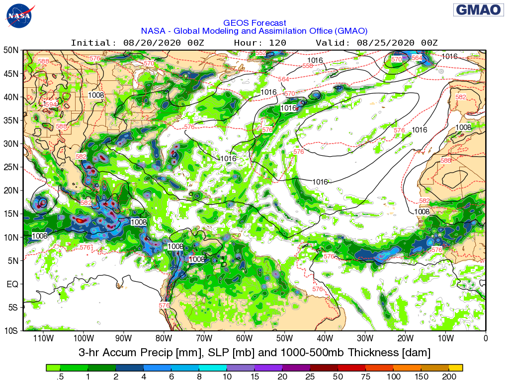
ATL: LAURA - Models

Moderator: S2k Moderators

Message
Author
caneseddy
Category 5
Category 5
Posts: 1172
Joined: Fri Sep 03, 2004 9:31 pm
Location: Plantation, FL

Re: ATL: THIRTEEN - Models

#1181 Postby caneseddy » Thu Aug 20, 2020 8:22 am

tolakram wrote:
DestinHurricane wrote:Not sure I buy the Matthew analogs. This setup reminds me more of Andrew.

Keep in mind that Matthew happened in October when throughs are stronger and send storms more poleward. This is august and we don't even have a trough.


Andrew moved NW before bending back west. Why does this remind you of Andrew?


To me, the setup looks bit more Irma'ish than Andrew. Like tolakram said, Andrew was heading NW and then made a hard left turn and just kept chugging westward. if TD13/Laura or Marco does form it would be coming from the ESE, like Irma was. He could have meant in strength and the upper level conditions that are ahead of it are identical to Andrew.

The posts in this forum are NOT official forecasts and should not be used as such. They are just the opinion of the poster and may or may not be backed by sound meteorological data. They are NOT endorsed by any professional institution or STORM2K. For official information, please refer to products from the NHC and NWS.
2 likes   

User avatar
DestinHurricane
Category 4
Category 4
Posts: 935
Joined: Tue May 01, 2018 8:05 am
Location: New York, NY

Re: ATL: THIRTEEN - Models

#1182 Postby DestinHurricane » Thu Aug 20, 2020 8:25 am

caneseddy wrote:
tolakram wrote:
DestinHurricane wrote:Not sure I buy the Matthew analogs. This setup reminds me more of Andrew.

Keep in mind that Matthew happened in October when throughs are stronger and send storms more poleward. This is august and we don't even have a trough.


Andrew moved NW before bending back west. Why does this remind you of Andrew?


To me, the setup looks bit more Irma'ish than Andrew. Like tolakram said, Andrew was heading NW and then made a hard left turn and just kept chugging westward. if TD13/Laura or Marco does form it would be coming from the ESE, like Irma was. He could have meant in strength and the upper level conditions that are ahead of it are identical to Andrew.


I'm talking about the ridging. The ridge keeps moving west and keeps pushing the storm west. I know Andrew came in from a slightly different angle but similar setup. Irma, like matthew, was picked up by trough IIRC.
2 likes   
Michael 2018

User avatar
CDO62
S2K Supporter
S2K Supporter
Posts: 105
Joined: Mon Sep 19, 2005 3:19 pm
Location: Tampa,FL

Re: ATL: THIRTEEN - Models

#1183 Postby CDO62 » Thu Aug 20, 2020 8:28 am

0 likes   

cp79

Re: ATL: THIRTEEN - Models

#1184 Postby cp79 » Thu Aug 20, 2020 8:36 am

How big of an impact will 97L have on TD13? I assume if 97L is stronger and moves more northerly that will cause TD13 to recurve north somewhere either before Fla or just after Fla. However if 97L moves more westerly and into Texas/Mexico, it gives TD13 more of a pathway into the Gulf. Is that right?
0 likes   

jlauderdal
S2K Supporter
S2K Supporter
Posts: 7183
Joined: Wed May 19, 2004 5:46 am
Location: NE Fort Lauderdale
Contact:

Re: ATL: THIRTEEN - Models

#1185 Postby jlauderdal » Thu Aug 20, 2020 8:41 am


ridge is really not too impressive on that run, regardless, prep your new genny today
2 likes   

User avatar
DestinHurricane
Category 4
Category 4
Posts: 935
Joined: Tue May 01, 2018 8:05 am
Location: New York, NY

Re: ATL: THIRTEEN - Models

#1186 Postby DestinHurricane » Thu Aug 20, 2020 8:42 am

jlauderdal wrote:
tolakram wrote:
DestinHurricane wrote:Not sure I buy the Matthew analogs. This setup reminds me more of Andrew.

Keep in mind that Matthew happened in October when throughs are stronger and send storms more poleward. This is august and we don't even have a trough.


Andrew moved NW before bending back west. Why does this remind you of Andrew?


There really needs to be far less comparison to Andrew when hurricanes come in, that was a very unique setup and very well might not be repeated in any of our lifetimes.


I don't mean in intensity. I'm just talking about ridging keeping pushing it west and not allowing it to gain much latitude.
2 likes   
Michael 2018

Shell Mound
Category 5
Category 5
Posts: 2434
Age: 32
Joined: Thu Sep 07, 2017 3:39 pm
Location: St. Petersburg, FL → Scandinavia

Re: ATL: THIRTEEN - Models

#1187 Postby Shell Mound » Thu Aug 20, 2020 8:42 am

jlauderdal wrote:


ridge is really not too impressive on that run, regardless, prep your new genny today

Yes, at this stage I think it will miss FL just to the east, but devastate the Bahamas, sadly. Regardless, everyone should be prepared!
0 likes   
CVW / MiamiensisWx / Shell Mound
The posts in this forum are NOT official forecasts and should not be used as such. They are just the opinion of the poster and may or may not be backed by sound meteorological data. They are NOT endorsed by any professional institution or STORM2K. For official information, please refer to products from the NHC and NWS.

HurricaneFrances04
Category 2
Category 2
Posts: 597
Joined: Mon Jun 25, 2012 8:09 am
Location: Fort Lauderdale, Florida

Re: ATL: THIRTEEN - Models

#1188 Postby HurricaneFrances04 » Thu Aug 20, 2020 8:45 am

Anyone have any thoughts as to why the GFS, NAVGEM, and CMC appear to show the heaviest precip to the SE of the center when it landfalls in Florida? ICON also has most of the precip to the south.

Of course, it's still 4-5 days out so taking it with a grain of salt. Just thought it was interesting.
0 likes   

User avatar
eastcoastFL
Category 5
Category 5
Posts: 3901
Age: 43
Joined: Thu Apr 12, 2007 12:29 pm
Location: Palm City, FL

Re: ATL: THIRTEEN - Models

#1189 Postby eastcoastFL » Thu Aug 20, 2020 8:50 am

jlauderdal wrote:


ridge is really not too impressive on that run, regardless, prep your new genny today


It’s prepped. If the stronger models play out I may just pack the car instead. I’m hoping they show a recurve next run.
0 likes   
Personal Forecast Disclaimer:
The posts in this forum are NOT official forecast and should not be used as such. They are just the opinion of the poster and may or may not be backed by sound meteorological data. They are NOT endorsed by any professional institution or storm2k.org. For official information, please refer to the NHC and NWS products.

User avatar
aspen
Category 5
Category 5
Posts: 8818
Joined: Sat Oct 12, 2019 7:10 pm
Location: Connecticut, USA

Re: ATL: THIRTEEN - Models

#1190 Postby aspen » Thu Aug 20, 2020 8:51 am

There is almost unanimous agreement among the global models that TD13 will track north of the Greater Antilles. The most recent GFS, CMC, NAVGEM, and ICON runs show a TC north of the islands, while the ECMWF shows a wave in the same area. Only the GFS-Para shows TD13 running into the GAs, but its run hasn’t finished yet, so we don’t know if it’ll pull north or end up strengthening in the Gulf.
2 likes   
Irene '11 Sandy '12 Hermine '16 5/15/2018 Derecho Fay '20 Isaias '20 Elsa '21 Henri '21 Ida '21

I am only a meteorology enthusiast who knows a decent amount about tropical cyclones. Look to the professional mets, the NHC, or your local weather office for the best information.

plasticup

Re: ATL: THIRTEEN - Models

#1191 Postby plasticup » Thu Aug 20, 2020 8:54 am

BobHarlem wrote:12z intensity.

https://i.imgur.com/k8sHf4p.png


Goodness that's a spread
0 likes   

User avatar
gatorcane
S2K Supporter
S2K Supporter
Posts: 23691
Age: 47
Joined: Sun Mar 13, 2005 3:54 pm
Location: Boca Raton, FL

Re: ATL: THIRTEEN - Models

#1192 Postby gatorcane » Thu Aug 20, 2020 8:59 am

The GMAO model has this on the weak side and recurving in the Bahamas east of Florida:

Image
2 likes   

User avatar
Evil Jeremy
S2K Supporter
S2K Supporter
Posts: 5463
Age: 32
Joined: Mon Apr 10, 2006 2:10 pm
Location: Los Angeles, CA

Re: ATL: THIRTEEN - Models

#1193 Postby Evil Jeremy » Thu Aug 20, 2020 9:01 am


"Just in time for hurricane season" he says, as we're literally halfway through the season's Atlantic names list.
3 likes   
Frances 04 / Jeanne 04 / Katrina 05 / Wilma 05 / Fay 08 / Debby 12 / Andrea 13 / Colin 16 / Hermine 16 / Matthew 16 / Irma 17

Nuno
Category 2
Category 2
Posts: 597
Joined: Fri Aug 30, 2019 8:35 am
Location: Coral Gables, FL

Re: ATL: THIRTEEN - Models

#1194 Postby Nuno » Thu Aug 20, 2020 9:06 am

toad strangler wrote:SOoooo far out (in mileage NOT time) still. Tracks will keep shifting.


We're in prime windshield wipe territory.
2 likes   
Andrew (1992), Irene (1999), Frances (2004), Katrina (2005), Wilma (2005), Fay (2008), Irma (2017), Eta (2020), Ian (2022)

User avatar
CourierPR
Category 5
Category 5
Posts: 1335
Age: 71
Joined: Tue Aug 31, 2004 7:53 pm
Location: Pompano Beach, Florida

Re: ATL: THIRTEEN - Models

#1195 Postby CourierPR » Thu Aug 20, 2020 9:11 am

Evil Jeremy wrote:


"Just in time for hurricane season" he says, as we're literally halfway through the season's Atlantic names list.


Folks on here have been swaying back and forth like trees in a hurricane with the models. It seems like the ensembles have a good grasp of what's going on with TD13.
1 likes   

User avatar
NDG
S2K Supporter
S2K Supporter
Posts: 15446
Joined: Sun Jul 09, 2006 10:14 pm
Location: Orlando, FL

Re: ATL: THIRTEEN - Models

#1196 Postby NDG » Thu Aug 20, 2020 9:35 am

The operational Euro has been struggling with TD 13 to say the least.

Image
0 likes   

User avatar
NDG
S2K Supporter
S2K Supporter
Posts: 15446
Joined: Sun Jul 09, 2006 10:14 pm
Location: Orlando, FL

Re: ATL: THIRTEEN - Models

#1197 Postby NDG » Thu Aug 20, 2020 9:38 am

gatorcane wrote:The GMAO model has this on the weak side and recurving in the Bahamas east of Florida:

https://i.postimg.cc/PqxbZKzw/cd897518-718e-37a4-8243-5a51b1d2d242.png


Let me ask you a question, why are you only posting a model that we have no idea how it has been verifying this hurricane season so far. Unless you have that information and you can share with me.
4 likes   

User avatar
TheDreamTraveler
Category 2
Category 2
Posts: 641
Joined: Sun Aug 22, 2010 3:10 am
Location: PA

Re: ATL: THIRTEEN - Models

#1198 Postby TheDreamTraveler » Thu Aug 20, 2020 9:38 am

CourierPR wrote:
Evil Jeremy wrote:


"Just in time for hurricane season" he says, as we're literally halfway through the season's Atlantic names list.


Folks on here have been swaying back and forth like trees in a hurricane with the models. It seems like the ensembles have a good grasp of what's going on with TD13.


Yeah if you listened to some of the people in the models thread you'd assume there'd still be no storms until the beginning of september just because gfs and euro model runs weren't showing anything despite a lot of evidence showing favorability, approaching peak season, and the fact the models are terrible at predicting cyclogenesis a few days out. That's why it's dangerous to listen and assume that the models are right because you wouldn't realize a potential hurricane was heading your way in 4 days lol tbh the models are STILL having a hard time with TD13 the euro still ends up turning it into an open wave but if you remember multiple euro and gfs runs had this *staying* as an open wave for days more after this
3 likes   

cp79

Re: ATL: THIRTEEN - Models

#1199 Postby cp79 » Thu Aug 20, 2020 9:39 am

New TD in Caribbean. I firmly believe this is what’s giving these models a headache. What happens with that could affect what happens with TD13.

Reminds me of Charley a bit. That storm was supposed to move north and ride the West Coast of Florida but TS Bonnie moved more easterly than expected and pushed Charley to make an unexpected NE shift at the last second, hitting Port Charlotte instead of Tampa Bay.
0 likes   

AutoPenalti
Category 5
Category 5
Posts: 4030
Age: 29
Joined: Mon Aug 17, 2015 4:16 pm
Location: Ft. Lauderdale, Florida

Re: ATL: THIRTEEN - Models

#1200 Postby AutoPenalti » Thu Aug 20, 2020 9:41 am

NDG wrote:
gatorcane wrote:The GMAO model has this on the weak side and recurving in the Bahamas east of Florida:

https://i.postimg.cc/PqxbZKzw/cd897518-718e-37a4-8243-5a51b1d2d242.png


Let me ask you a question, why are you only posting a model that we have no idea how it has been verifying this hurricane season so far. Unless you have that information and you can share with me.

To be fair, it’s the models thread so it’s okay. I don’t know much about this model but from the little I know it did horrible with Irma.
0 likes   
The posts in this forum are NOT official forecasts and should not be used as such. They are just the opinion of the poster and may or may not be backed by sound meteorological data. They are NOT endorsed by any professional institution or STORM2K. For official information, please refer to products from the NHC and NWS.


Model Runs Cheat Sheet:
GFS (5:30 AM/PM, 11:30 AM/PM)
HWRF, GFDL, UKMET, NAVGEM (6:30-8:00 AM/PM, 12:30-2:00 AM/PM)
ECMWF (1:45 AM/PM)

TCVN
is a weighted averaged


Return to “2020”

Who is online

Users browsing this forum: No registered users and 8 guests