
WPAC: MAN-YI - Post-Tropical
Moderator: S2k Moderators
-
WaveBreaking

- Category 2

- Posts: 727
- Joined: Sun Jun 30, 2024 11:33 am
- Location: US
Re: WPAC: MAN-YI - Typhoon
3 likes
I am NOT a professional meteorologist, so take all of my posts with a grain of salt. My opinions are mine and mine alone.
-
doomhaMwx

- Category 5

- Posts: 2492
- Age: 27
- Joined: Tue Apr 18, 2017 4:01 am
- Location: Baguio/Benguet, Philippines
- Contact:
Re: WPAC: MAN-YI - Typhoon
Hurricane2022 wrote:Where is Josh Morgerman right now? He will be inside the Eye of Man-yi?
https://x.com/iCyclone/status/1858029792039203207
Looks like he'll get in the eye later based on radar.
0 likes
-
mrbagyo

- Category 5
- Posts: 3984
- Age: 33
- Joined: Thu Apr 12, 2012 9:18 am
- Location: 14.13N 120.98E
- Contact:
Re: WPAC: MAN-YI - Typhoon
Hurricane2022 wrote:Where is Josh Morgerman right now? He will be inside the Eye of Man-yi?
I was able to talk to him awhile ago, he went up north.
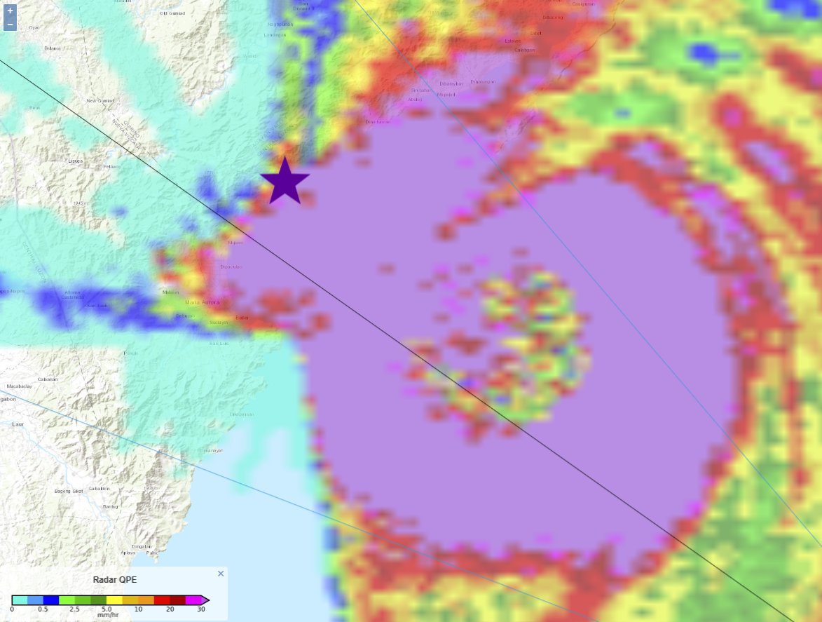
I think he nailed the Eye in Dipaculao.
It's mayhem here in Baler with whistlin offshore wind and this is the weak side.
1 likes
The posts in this forum are NOT official forecast and should not be used as such. They are just the opinion of the poster and may or may not be backed by sound meteorological data. They are NOT endorsed by any professional institution or storm2k.org. For official information, please refer to RSMC, NHC and NWS products.
-
xtyphooncyclonex

- Category 5
- Posts: 3898
- Age: 24
- Joined: Sat Dec 08, 2012 9:07 am
- Location: Cebu City
- Contact:
Re: WPAC: MAN-YI - Typhoon
0 likes
REMINDER: My opinions that I, or any other NON Pro-Met in this forum, are unofficial. Please do not take my opinions as an official forecast and warning. I am NOT a meteorologist. Following my forecasts blindly may lead to false alarm, danger and risk if official forecasts from agencies are ignored.
-
doomhaMwx
- Category 5
- Posts: 2492
- Age: 27
- Joined: Tue Apr 18, 2017 4:01 am
- Location: Baguio/Benguet, Philippines
- Contact:
Re: WPAC: MAN-YI - Typhoon
Yesterday's data from PAGASA Baler AWS, which was located just south of Man-Yi's eye. Lowest sea-level pressure was 964.2 mb at 2:50pm PhT (06:50Z), and station went offline after 3pm.


0 likes
-
Hurricane2022

- Category 5
- Posts: 2084
- Joined: Tue Aug 23, 2022 11:38 pm
- Location: Araçatuba, Brazil
Re: WPAC: MAN-YI - Typhoon
0 likes
Sorry for the bad English sometimes...!
For reliable and detailed information for any meteorological phenomenon, please consult the National Hurricane Center, Joint Typhoon Warning Center , or your local Meteo Center.
--------
ECCE OMNIA NOVA FACIAM (Ap 21,5).
For reliable and detailed information for any meteorological phenomenon, please consult the National Hurricane Center, Joint Typhoon Warning Center , or your local Meteo Center.
--------
ECCE OMNIA NOVA FACIAM (Ap 21,5).
-
xtyphooncyclonex
- Category 5
- Posts: 3898
- Age: 24
- Joined: Sat Dec 08, 2012 9:07 am
- Location: Cebu City
- Contact:
Re: WPAC: MAN-YI - Typhoon
When Josh says it's bad, it was really bad...
1 likes
REMINDER: My opinions that I, or any other NON Pro-Met in this forum, are unofficial. Please do not take my opinions as an official forecast and warning. I am NOT a meteorologist. Following my forecasts blindly may lead to false alarm, danger and risk if official forecasts from agencies are ignored.
-
cycloneye

- Admin

- Posts: 149668
- Age: 69
- Joined: Thu Oct 10, 2002 10:54 am
- Location: San Juan, Puerto Rico
Re: WPAC: MAN-YI - Tropical Storm
JMA downgrades.
T2424(Man-yi)
Issued at 2024/11/18 12:45 UTC
Analysis at 11/18 12 UTC
Grade STS
Scale -
Intensity -
Center position N18°55′ (18.9°)
E116°00′ (116.0°)
Direction and speed of movement WNW 20 km/h (12 kt)
Central pressure 985 hPa
Maximum sustained wind speed near center 30 m/s (60 kt)
Maximum wind gust speed 45 m/s (85 kt)
Radius of 50-kt wind area 45 km (25 NM)
Radius of 30-kt wind area N220 km (120 NM)
S165 km (90 NM)
0 likes
Visit the Caribbean-Central America Weather Thread where you can find at first post web cams,radars
and observations from Caribbean basin members Click Here
and observations from Caribbean basin members Click Here
-
mrbagyo
- Category 5
- Posts: 3984
- Age: 33
- Joined: Thu Apr 12, 2012 9:18 am
- Location: 14.13N 120.98E
- Contact:
Re: WPAC: MAN-YI - Typhoon
basically, most ferocious since Dorian based on his experience.
Walked around the town of Baler earlier and what I saw were just typical typhoon damage like fallen trees (mostly exotic trees) and some roof failure on not well constructed buildings but overall i would say Baler dodged a freakin missile.
The town where Josh intercepted the eye and the next town up north took the full brunt of Man-yi. We haven't seen the full extent of it yet.
1 likes
The posts in this forum are NOT official forecast and should not be used as such. They are just the opinion of the poster and may or may not be backed by sound meteorological data. They are NOT endorsed by any professional institution or storm2k.org. For official information, please refer to RSMC, NHC and NWS products.
-
xtyphooncyclonex
- Category 5
- Posts: 3898
- Age: 24
- Joined: Sat Dec 08, 2012 9:07 am
- Location: Cebu City
- Contact:
Re: WPAC: MAN-YI - Tropical Storm
0 likes
REMINDER: My opinions that I, or any other NON Pro-Met in this forum, are unofficial. Please do not take my opinions as an official forecast and warning. I am NOT a meteorologist. Following my forecasts blindly may lead to false alarm, danger and risk if official forecasts from agencies are ignored.
Re: WPAC: MAN-YI - Typhoon
Is your family okay with you inserting yourself into the path of a killer cyclone? I mean you no disrespect, but I wonder. I'm glad you are safe.
0 likes
-
mrbagyo
- Category 5
- Posts: 3984
- Age: 33
- Joined: Thu Apr 12, 2012 9:18 am
- Location: 14.13N 120.98E
- Contact:
Re: WPAC: MAN-YI - Tropical Storm
Here's some of Stas' intense footage.
We actually stayed at the same hotel but he checked out earlier to search for a better location up north
https://twitter.com/StasisChasing/status/1858664420706316305
We actually stayed at the same hotel but he checked out earlier to search for a better location up north
https://twitter.com/StasisChasing/status/1858664420706316305
0 likes
The posts in this forum are NOT official forecast and should not be used as such. They are just the opinion of the poster and may or may not be backed by sound meteorological data. They are NOT endorsed by any professional institution or storm2k.org. For official information, please refer to RSMC, NHC and NWS products.
-
doomhaMwx
- Category 5
- Posts: 2492
- Age: 27
- Joined: Tue Apr 18, 2017 4:01 am
- Location: Baguio/Benguet, Philippines
- Contact:
Re: WPAC: MAN-YI - Tropical Storm
My estimate at central pressure landfall is ~940 mb based on obs from Baler. Can't wait to see Josh's data in the eye!
0 likes
-
cycloneye
- Admin
- Posts: 149668
- Age: 69
- Joined: Thu Oct 10, 2002 10:54 am
- Location: San Juan, Puerto Rico
Re: WPAC: MAN-YI - Tropical Storm
0 likes
Visit the Caribbean-Central America Weather Thread where you can find at first post web cams,radars
and observations from Caribbean basin members Click Here
and observations from Caribbean basin members Click Here
-
cycloneye
- Admin
- Posts: 149668
- Age: 69
- Joined: Thu Oct 10, 2002 10:54 am
- Location: San Juan, Puerto Rico
Re: WPAC: MAN-YI - Tropical Storm
1 likes
Visit the Caribbean-Central America Weather Thread where you can find at first post web cams,radars
and observations from Caribbean basin members Click Here
and observations from Caribbean basin members Click Here
-
cycloneye
- Admin
- Posts: 149668
- Age: 69
- Joined: Thu Oct 10, 2002 10:54 am
- Location: San Juan, Puerto Rico
Re: WPAC: MAN-YI - Post-Tropical
Is over but was an impactable one and reached cat 5.
0 likes
Visit the Caribbean-Central America Weather Thread where you can find at first post web cams,radars
and observations from Caribbean basin members Click Here
and observations from Caribbean basin members Click Here
-
doomhaMwx
- Category 5
- Posts: 2492
- Age: 27
- Joined: Tue Apr 18, 2017 4:01 am
- Location: Baguio/Benguet, Philippines
- Contact:
Re: WPAC: MAN-YI - Post-Tropical
1 likes
-
mrbagyo
- Category 5
- Posts: 3984
- Age: 33
- Joined: Thu Apr 12, 2012 9:18 am
- Location: 14.13N 120.98E
- Contact:
Re: WPAC: MAN-YI - Post-Tropical
0 likes
The posts in this forum are NOT official forecast and should not be used as such. They are just the opinion of the poster and may or may not be backed by sound meteorological data. They are NOT endorsed by any professional institution or storm2k.org. For official information, please refer to RSMC, NHC and NWS products.
-
mrbagyo
- Category 5
- Posts: 3984
- Age: 33
- Joined: Thu Apr 12, 2012 9:18 am
- Location: 14.13N 120.98E
- Contact:
Re: WPAC: MAN-YI - Post-Tropical
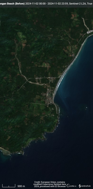
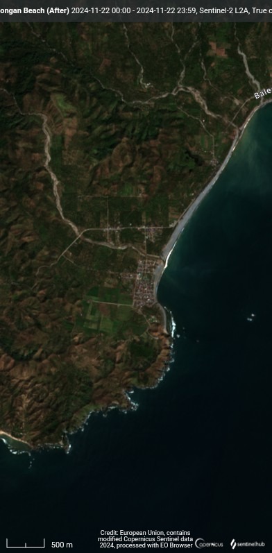
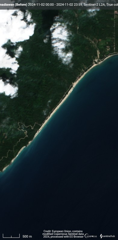
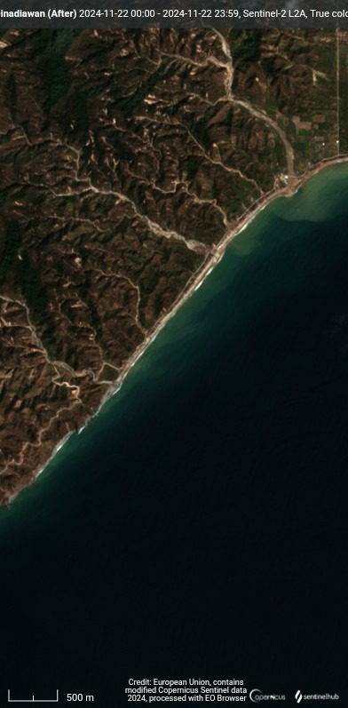
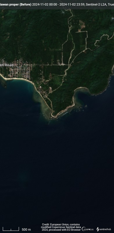
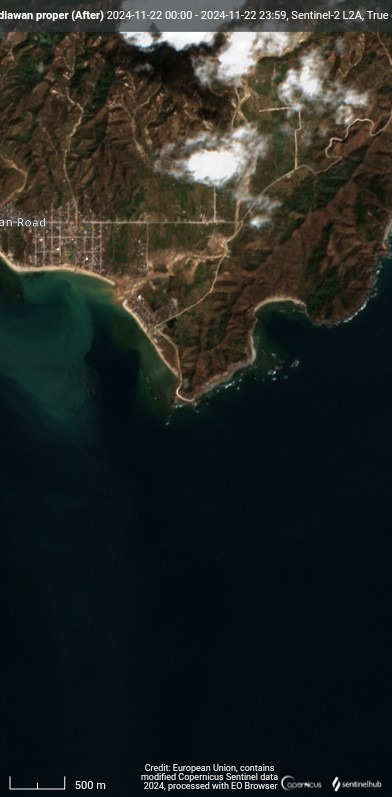
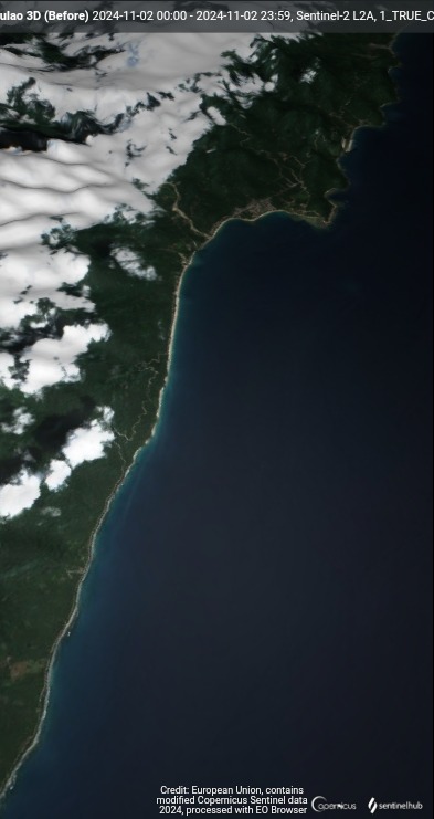
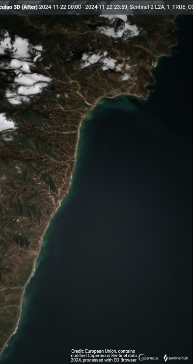
Here are some Before and After satellite images of Dipaculao as captured by Sentinel-2 satellite
Borlongan Beach
Dinadiawan Beach
Dinadiawan Proper
Dipaculao Coast 3D
Borlongan Beach
Dinadiawan Beach
Dinadiawan Proper
Dipaculao Coast 3D
0 likes
The posts in this forum are NOT official forecast and should not be used as such. They are just the opinion of the poster and may or may not be backed by sound meteorological data. They are NOT endorsed by any professional institution or storm2k.org. For official information, please refer to RSMC, NHC and NWS products.
Who is online
Users browsing this forum: No registered users and 57 guests