ATL: SARA - Models

Moderator: S2k Moderators

Message
Author
User avatar
N2FSU
S2K Supporter
S2K Supporter
Posts: 1062
Joined: Thu Sep 04, 2003 2:04 pm
Location: Tallahassee, FL

Re: ATL: SARA - Models

#121 Postby N2FSU » Fri Nov 15, 2024 9:22 am

6z

Image


Sent from my iPhone using Tapatalk
0 likes   

User avatar
N2FSU
S2K Supporter
S2K Supporter
Posts: 1062
Joined: Thu Sep 04, 2003 2:04 pm
Location: Tallahassee, FL

Re: ATL: SARA - Models

#122 Postby N2FSU » Fri Nov 15, 2024 9:23 am

6z

Image


Sent from my iPhone using Tapatalk
0 likes   

User avatar
chaser1
S2K Supporter
S2K Supporter
Posts: 5406
Age: 64
Joined: Sat Oct 15, 2005 5:59 pm
Location: Longwood, Fl

Re: ATL: SARA - Models

#123 Postby chaser1 » Fri Nov 15, 2024 9:36 am

HAFS models seem to be hinting at some extent of redevelopment in spite of obvious shear. Perhaps the models are projecting the east GOM to once again moisten up ahead of the next cold front?
0 likes   
Andy D

(For official information, please refer to the NHC and NWS products.)

tolakram
Admin
Admin
Posts: 19989
Age: 61
Joined: Sun Aug 27, 2006 8:23 pm
Location: Florence, KY (name is Mark)

Re: ATL: SARA - Models

#124 Postby tolakram » Fri Nov 15, 2024 10:02 am

Looks like timing will be everything.

Image
0 likes   
M a r k
- - - - -
Join us in chat: Storm2K Chatroom Invite. Android and IOS apps also available.

The posts in this forum are NOT official forecasts and should not be used as such. Posts are NOT endorsed by any professional institution or STORM2K.org. For official information and forecasts, please refer to NHC and NWS products.

User avatar
ThunderForce
Tropical Storm
Tropical Storm
Posts: 208
Age: 25
Joined: Tue Sep 27, 2022 6:20 pm
Location: Calhoun County, Florida

Re: ATL: SARA - Models

#125 Postby ThunderForce » Sat Nov 16, 2024 12:59 pm

Uh... is this a hurricane? HAFS-A is showing a sub-990 mb storm from Sara's remnants.
Image
2 likes   
Please refer to the NWS, NHC, SPC or a professional meteorologist for information and decision making during storms.

Stormlover70
Tropical Storm
Tropical Storm
Posts: 167
Age: 55
Joined: Fri Jun 21, 2024 5:31 am
Location: New port richey

Re: ATL: SARA - Models

#126 Postby Stormlover70 » Sat Nov 16, 2024 3:40 pm

ThunderForce wrote:Uh... is this a hurricane? HAFS-A is showing a sub-990 mb storm from Sara's remnants.
https://i.postimg.cc/KYsSF9Xw/hafsa-mslp-wind-19-L-29.png
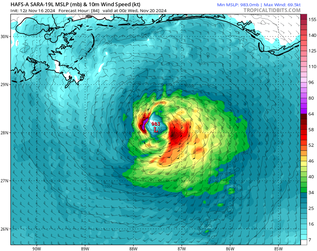
way overdone. The cold front is going to prevent any storm that strong. A frontal low with severe weather is more likely.
1 likes   

User avatar
Emmett_Brown
Category 5
Category 5
Posts: 1432
Joined: Wed Aug 24, 2005 9:10 pm
Location: Sarasota FL

Re: ATL: SARA - Models

#127 Postby Emmett_Brown » Sat Nov 16, 2024 5:17 pm

Interesting setup. The globals mostly dissipate Sara over Belize/Mexico, but do show some mid level vorticity making it back into the GOM on Monday 11/18. The HAFS A and B, HWRF and HMON have consistently been showing some moderate development of the remnant vorticity. While SSTs in the GOM have cooled due to multiple storms, SSTs are still well above normal for this time of year. Global models only showed modest development of what became MIlton and have often played catchup this year with over performing GOM storms. I will certainly be watching until the front absorbs Sara completely.
4 likes   

User avatar
chaser1
S2K Supporter
S2K Supporter
Posts: 5406
Age: 64
Joined: Sat Oct 15, 2005 5:59 pm
Location: Longwood, Fl

Re: ATL: SARA - Models

#128 Postby chaser1 » Sat Nov 16, 2024 6:09 pm

I havnt had the chance to compare the globals verses the regional models but the only possible solution for the discrepancy that I could think of might be either the regional models are forecasting a quicker timetable for Sara to into the east-central Gulf and remaining within the warm sector ahead of the front? That or, the regional models might be forecasting the front to be slightly delayed reaching the north GOM. I'll probably review the NAM in case of a "timing tie-breaker" LOL.
1 likes   
Andy D

(For official information, please refer to the NHC and NWS products.)

User avatar
Emmett_Brown
Category 5
Category 5
Posts: 1432
Joined: Wed Aug 24, 2005 9:10 pm
Location: Sarasota FL

Re: ATL: SARA - Models

#129 Postby Emmett_Brown » Sun Nov 17, 2024 1:14 pm

The HAFS A, B and HWRF have backed away from regenerating Sara over the GOM; now they just show some remnant low pressure. I'll still keep an eye on it. Mitch spent way more time over land than Sara is supposed to, and still managed to regenerate into a respectable TS... so there's always a slim chance (very slim in Sara's case)
1 likes   

User avatar
tropicwatch
Category 5
Category 5
Posts: 3364
Age: 61
Joined: Sat Jun 02, 2007 10:01 am
Location: Panama City Florida
Contact:

Re: ATL: SARA - Models

#130 Postby tropicwatch » Sun Nov 17, 2024 1:44 pm

1 likes   
Tropicwatch


Agnes 72', Eloise 75, Elena 85', Kate 85', Charley 86', Florence 88', Beryl 94', Dean 95', Erin 95', Opal 95', Earl 98', Georges 98', Ivan 2004', Arlene 2005', Dennis 2005', Ida 2009' Debby 2012' Irma 2017' Michael 2018'

Stormlover70
Tropical Storm
Tropical Storm
Posts: 167
Age: 55
Joined: Fri Jun 21, 2024 5:31 am
Location: New port richey

Re: ATL: SARA - Models

#131 Postby Stormlover70 » Sun Nov 17, 2024 7:19 pm

The peninsula as well.
1 likes   


Return to “2024”

Who is online

Users browsing this forum: No registered users and 12 guests