ATL: ERIN - Models

Moderator: S2k Moderators

Message
Author
BobHarlem
Category 5
Category 5
Posts: 2362
Joined: Thu Oct 20, 2005 6:11 pm

Re: ATL: INVEST 97L - Models

#121 Postby BobHarlem » Sun Aug 10, 2025 10:20 pm

Icon 0z: At 114 hours out (to match 18z) it's left/south of 18z (21.6N was 23.1N at 18z) and a little weaker. Significantly left/south of 12z (which was 24.5N)
Image]

Last frame, much further southwest, 12z was recurving east of Bermuda, this one looks to be going west of it. Also note system east of it. Icon weaker than the other models in general.
Image
1 likes   

IcyTundra
Category 5
Category 5
Posts: 1220
Joined: Mon Jun 07, 2021 9:32 pm
Location: Dickinson, Texas

Re: ATL: INVEST 97L - Models

#122 Postby IcyTundra » Sun Aug 10, 2025 11:12 pm

0Z GFS is a little south of the 18Z run through 120 hours. 2nd run in a row with a south shift.
0 likes   

LarryWx
S2K Supporter
S2K Supporter
Posts: 6508
Joined: Sun Sep 07, 2003 2:04 pm
Location: GA

Re: ATL: INVEST 97L - Models

#123 Postby LarryWx » Sun Aug 10, 2025 11:13 pm

0Z UKMET recurves along 63.3W:

NEW TROPICAL CYCLONE FORECAST TO DEVELOP AFTER 30 HOURS
FORECAST POSITION AT T+ 30 : 17.8N 32.8W

LEAD CENTRAL MAXIMUM WIND
VERIFYING TIME TIME POSITION PRESSURE (MB) SPEED (KNOTS)
-------------- ---- -------- ------------- -------------
1200UTC 12.08.2025 36 18.1N 35.6W 1008 32
0000UTC 13.08.2025 48 17.5N 39.4W 1007 29
1200UTC 13.08.2025 60 17.9N 42.4W 1007 30
0000UTC 14.08.2025 72 18.8N 45.3W 1007 31
1200UTC 14.08.2025 84 19.9N 48.8W 1007 31
0000UTC 15.08.2025 96 20.5N 51.8W 1006 30
1200UTC 15.08.2025 108 21.0N 54.9W 1005 40
0000UTC 16.08.2025 120 21.7N 57.2W 1004 42
1200UTC 16.08.2025 132 22.8N 60.0W 1003 46
0000UTC 17.08.2025 144 23.9N 61.7W 1003 44
1200UTC 17.08.2025 156 25.7N 63.3W 1003 42
0000UTC 18.08.2025 168 28.1N 63.3W 1003 45
0 likes   
Personal Forecast Disclaimer:
The posts in this forum are NOT official forecasts and should not be used as such. They are just the opinion of the poster and may or may not be backed by sound meteorological data. They are NOT endorsed by any professional institution or storm2k.org. For official information, please refer to the NHC and NWS products.

IcyTundra
Category 5
Category 5
Posts: 1220
Joined: Mon Jun 07, 2021 9:32 pm
Location: Dickinson, Texas

Re: ATL: INVEST 97L - Models

#124 Postby IcyTundra » Sun Aug 10, 2025 11:21 pm

The ridge is stronger on the 0Z GFS but it looks like the recurve is going to begin near 65W with the ridge weakening. It is also quite a bit weaker than the 18Z run (20+ mb weaker).
0 likes   

Pelicane
Tropical Storm
Tropical Storm
Posts: 124
Joined: Tue Sep 13, 2022 1:52 pm
Location: Lafayette, Louisiana

Re: ATL: INVEST 97L - Models

#125 Postby Pelicane » Sun Aug 10, 2025 11:21 pm

Euro and the GFS may be lining up a bit.
1 likes   

lsuhurricane
Category 1
Category 1
Posts: 261
Joined: Tue Aug 15, 2017 2:53 pm

Re: ATL: INVEST 97L - Models

#126 Postby lsuhurricane » Sun Aug 10, 2025 11:21 pm

I’d say this GFS run is about to perk some interest. Ridging building in across the NE USA
2 likes   

Pelicane
Tropical Storm
Tropical Storm
Posts: 124
Joined: Tue Sep 13, 2022 1:52 pm
Location: Lafayette, Louisiana

Re: ATL: INVEST 97L - Models

#127 Postby Pelicane » Sun Aug 10, 2025 11:29 pm

lsuhurricane wrote:I’d say this GFS run is about to perk some interest. Ridging building in across the NE USA


It's a similar setup to the 8/9 18z run that did end up impacing the NE fwiw
0 likes   

BobHarlem
Category 5
Category 5
Posts: 2362
Joined: Thu Oct 20, 2005 6:11 pm

Re: ATL: INVEST 97L - Models

#128 Postby BobHarlem » Sun Aug 10, 2025 11:33 pm

Ridge trends the last 4 runs (hint new 0z is the one where it's the furthest southwest)
Image
2 likes   

Ian2401
Category 1
Category 1
Posts: 319
Joined: Thu Sep 14, 2017 5:55 pm
Location: Tallahassee, Florida
Contact:

Re: ATL: INVEST 97L - Models

#129 Postby Ian2401 » Sun Aug 10, 2025 11:36 pm

Pelicane wrote:
lsuhurricane wrote:I’d say this GFS run is about to perk some interest. Ridging building in across the NE USA


It's a similar setup to the 8/9 18z run that did end up impacing the NE fwiw


That run had significantly stronger ridging in the NE at the same time. Looks like a trough is coming in to kick future Erin out in the last few frames of this run.

Still, a massive shift SW and highlights why even large scale synoptic patterns are untrustworthy this far out.
3 likes   
B.S. Meteorology from Florida State '24 // Current M.S. Meteorology student at Florida State

Research Interests: Rapid Intensification, TC Climatology, TC Modeling

Consult the NHC for official information

BobHarlem
Category 5
Category 5
Posts: 2362
Joined: Thu Oct 20, 2005 6:11 pm

Re: ATL: INVEST 97L - Models

#130 Postby BobHarlem » Sun Aug 10, 2025 11:38 pm

0z GFS, about as far West of bermuda as it was east of Bermuda at 12z. Probably about as far west as it gets this run. Does landfall in Southeastern Newfoundland.
Image

Clips Newfoundland here:
Image
Last edited by BobHarlem on Sun Aug 10, 2025 11:53 pm, edited 5 times in total.
0 likes   

User avatar
Hurricaneman
Category 5
Category 5
Posts: 7396
Age: 45
Joined: Tue Aug 31, 2004 3:24 pm
Location: central florida

Re: ATL: INVEST 97L - Models

#131 Postby Hurricaneman » Sun Aug 10, 2025 11:43 pm

The track on the 0zGFS is similar to Bill in 2009
0 likes   

User avatar
Beef Stew
Category 2
Category 2
Posts: 518
Joined: Sat May 30, 2020 11:31 am
Location: South Florida

Re: ATL: INVEST 97L - Models

#132 Postby Beef Stew » Sun Aug 10, 2025 11:43 pm

The escape is there, but it may come quite close to Canada on this run.
0 likes   

User avatar
Beef Stew
Category 2
Category 2
Posts: 518
Joined: Sat May 30, 2020 11:31 am
Location: South Florida

Re: ATL: INVEST 97L - Models

#133 Postby Beef Stew » Sun Aug 10, 2025 11:51 pm

Yep, into Newfoundland as a strong extratropical cyclone at hour 270.
1 likes   

User avatar
cycloneye
Admin
Admin
Posts: 146346
Age: 69
Joined: Thu Oct 10, 2002 10:54 am
Location: San Juan, Puerto Rico

Re: ATL: INVEST 97L - Models

#134 Postby cycloneye » Mon Aug 11, 2025 2:50 am

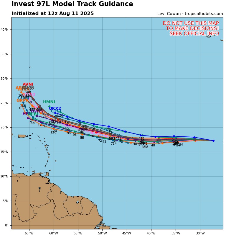
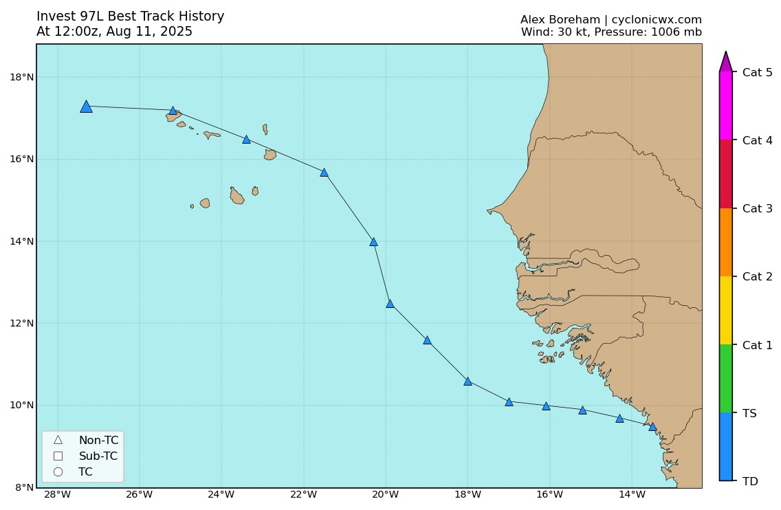
06z models.

Image

Image
0 likes   
Visit the Caribbean-Central America Weather Thread where you can find at first post web cams,radars
and observations from Caribbean basin members Click Here

User avatar
Hurricane2022
Category 5
Category 5
Posts: 1645
Joined: Tue Aug 23, 2022 11:38 pm
Location: Araçatuba, Brazil

Re: ATL: INVEST 97L - Models

#135 Postby Hurricane2022 » Mon Aug 11, 2025 5:08 am

0 likes   
Sorry for the bad English sometimes...!
For reliable and detailed information for any meteorological phenomenon, please consult the National Hurricane Center, Joint Typhoon Warning Center , or your local Meteo Center.

--------

Una cvm Christo, pro Christo, et in Christo. Sit nomen Domini benedictvm.

User avatar
cycloneye
Admin
Admin
Posts: 146346
Age: 69
Joined: Thu Oct 10, 2002 10:54 am
Location: San Juan, Puerto Rico

Re: ATL: INVEST 97L - Models

#136 Postby cycloneye » Mon Aug 11, 2025 5:33 am

The Euro AIFS now more east and no longer goes to Florida, moves east of Carolinas, the NE and reach New Foundland.

Image
4 likes   
Visit the Caribbean-Central America Weather Thread where you can find at first post web cams,radars
and observations from Caribbean basin members Click Here

Cachondo23
Tropical Storm
Tropical Storm
Posts: 104
Joined: Wed May 25, 2022 5:56 am

Re: ATL: INVEST 97L - Models

#137 Postby Cachondo23 » Mon Aug 11, 2025 6:35 am

Current GFS could be trouble for Bermuda. No OTS if it hits that tiny island.
0 likes   

User avatar
syfr
S2K Supporter
S2K Supporter
Posts: 201
Age: 106
Joined: Fri Oct 26, 2012 7:33 pm
Location: East Central NC

Re: ATL: INVEST 97L - Models

#138 Postby syfr » Mon Aug 11, 2025 6:49 am

cycloneye wrote:The Euro AIFS now more east and no longer goes to Florida, moves east of Carolinas, the NE and reach New Foundland.


That's quite a hook from S. Fla to just east of the OB!
0 likes   
I'm not a meteorologist, I'm an electronics engineer. While I can probably fix your toaster oven, you're not going to learn about storms from me!

New Mexico had no hurricanes. Then I moved to NC right before Fran.....

User avatar
Blown Away
S2K Supporter
S2K Supporter
Posts: 10166
Joined: Wed May 26, 2004 6:17 am

Re: ATL: INVEST 97L - Models

#139 Postby Blown Away » Mon Aug 11, 2025 8:39 am

Image
12z... Still likely recurve, but the cluster keeps moving farther S and W...

Image
12z Location... W turn has begun...
1 likes   
Hurricane Eye Experience: David 79, Irene 99, Frances 04, Jeanne 04, Wilma 05… Hurricane Brush Experience: Andrew 92, Erin 95, Floyd 99, Matthew 16, Irma 17, Ian 22, Nicole 22…

User avatar
Hurricane2022
Category 5
Category 5
Posts: 1645
Joined: Tue Aug 23, 2022 11:38 pm
Location: Araçatuba, Brazil

Re: ATL: INVEST 97L - Models

#140 Postby Hurricane2022 » Mon Aug 11, 2025 9:02 am

Oh boyyy :lol: :lol:
Image


:eek:...
2 likes   
Sorry for the bad English sometimes...!
For reliable and detailed information for any meteorological phenomenon, please consult the National Hurricane Center, Joint Typhoon Warning Center , or your local Meteo Center.

--------

Una cvm Christo, pro Christo, et in Christo. Sit nomen Domini benedictvm.


Return to “2025”

Who is online

Users browsing this forum: No registered users and 12 guests