ENSO Updates (2007 thru 2023)

This is the general tropical discussion area. Anyone can take their shot at predicting a storms path.

Moderator: S2k Moderators

Forum rules

The posts in this forum are NOT official forecasts and should not be used as such. They are just the opinion of the poster and may or may not be backed by sound meteorological data. They are NOT endorsed by any professional institution or STORM2K. For official information, please refer to products from the National Hurricane Center and National Weather Service.

Help Support Storm2K
Message
Author
User avatar
wxman57
Moderator-Pro Met
Moderator-Pro Met
Posts: 22978
Age: 67
Joined: Sat Jun 21, 2003 8:06 pm
Location: Houston, TX (southwest)

Re: ENSO Updates=Models forecast Neutral to Weak La Nina

#1201 Postby wxman57 » Fri Mar 26, 2010 8:13 am

srainhoutx wrote:
wxman57 wrote:It does look very likely that El Nino will not be a factor in the Atlantic Basin in 2010.


Looks like an active year for your team wxman57. Aren't you just thrilled about all the weekends you'll be in the office. :wink:


I'm already planning on working 7 days a week in August and September, and maybe before and beyond then. It was nice having the break in 2009. It'll be interesting to see what Klotzbach/Gray say next Wednesday at the NHC. I'll probably run into Phil on Tuesday and get a little inside info on the new forecast. I think he'll be upping the numbers for 2010 to around 15-16 named storms, though I think the number could still be higher. Hard to account for some variables in naming, though, like the 40 mph TS that's named after it moves inland into Central America, or the STS named by the Azores, or a very short-lived TS by the Cape Verde Islands.
0 likes   

User avatar
srainhoutx
S2K Supporter
S2K Supporter
Posts: 6919
Age: 67
Joined: Sun Jan 14, 2007 11:34 am
Location: Haywood County, NC
Contact:

Re: ENSO Updates=Models forecast Neutral to Weak La Nina

#1202 Postby srainhoutx » Fri Mar 26, 2010 8:16 am

wxman57 wrote:
srainhoutx wrote:
wxman57 wrote:It does look very likely that El Nino will not be a factor in the Atlantic Basin in 2010.


Looks like an active year for your team wxman57. Aren't you just thrilled about all the weekends you'll be in the office. :wink:


I'm already planning on working 7 days a week in August and September, and maybe before and beyond then. It was nice having the break in 2009. It'll be interesting to see what Klotzbach/Gray say next Wednesday at the NHC. I'll probably run into Phil on Tuesday and get a little inside info on the new forecast. I think he'll be upping the numbers for 2010 to around 15-16 named storms, though I think the number could still be higher.


Just wish we could get you some 80's while in FL. :wink: Look foward to your thoughts after the conference. :ggreen:
0 likes   
Carla/Alicia/Jerry(In The Eye)/Michelle/Charley/Ivan/Dennis/Katrina/Rita/Wilma/Ike/Harvey

Member: National Weather Association
Wx Infinity Forums
http://wxinfinity.com/index.php

Facebook.com/WeatherInfinity
Twitter @WeatherInfinity

User avatar
cycloneye
Admin
Admin
Posts: 145308
Age: 68
Joined: Thu Oct 10, 2002 10:54 am
Location: San Juan, Puerto Rico

Re: ENSO Updates=Models forecast Neutral to Weak La Nina

#1203 Postby cycloneye » Fri Mar 26, 2010 10:37 am

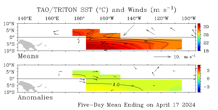
I look at this TAO graphic everyday as it updates daily to see how the anomalies are doing and also the wind directions.It looks like the warm ssta's are shrinking slowly and the winds are easterly and not from the west,meaning that no new kevin waves are on sight in the near future.

Image
0 likes   
Visit the Caribbean-Central America Weather Thread where you can find at first post web cams,radars
and observations from Caribbean basin members Click Here

User avatar
cycloneye
Admin
Admin
Posts: 145308
Age: 68
Joined: Thu Oct 10, 2002 10:54 am
Location: San Juan, Puerto Rico

Re: ENSO Updates=Models forecast Neutral to Weak La Nina

#1204 Postby cycloneye » Sat Mar 27, 2010 10:34 am

When you see this graphic,concentrate on the blue lines and not on the red ones as those blue are the recent 40 ensembles imput.I think CFS is the best solution of the ENSO models that has the best outlook of expected conditions.ECM and the Japanese may be too extreme towards a full blown La Nina in a relative short period of time.

Image
0 likes   
Visit the Caribbean-Central America Weather Thread where you can find at first post web cams,radars
and observations from Caribbean basin members Click Here

User avatar
KWT
Category 5
Category 5
Posts: 31415
Joined: Tue Aug 17, 2004 11:02 am
Location: UK!!!

#1205 Postby KWT » Sat Mar 27, 2010 6:18 pm

Yeah I agree cycloneye however that being said the CFS does seem to be trending more and more into La Nina grounds which would make 1998 a cracking match in terms of broad set-ups.

Pretty much the risk of El Nino is gone according to the forecasts, its now whether we go into full blown La Nina or not...
0 likes   
Personal Forecast Disclaimer:
The posts in this forum are NOT official forecast and should not be used as such. They are just the opinion of the poster and may or may not be backed by sound meteorological data. They are NOT endorsed by any professional institution or storm2k.org. For official information, please refer to the NHC and NWS products

User avatar
cycloneye
Admin
Admin
Posts: 145308
Age: 68
Joined: Thu Oct 10, 2002 10:54 am
Location: San Juan, Puerto Rico

Re: ENSO Updates=Models forecast between Neutral and La Nina

#1206 Postby cycloneye » Sun Mar 28, 2010 2:28 pm

I have noticed that there is a difference between some models in terms of the threshold number for El Nino / La Nina.For example,Climate Prediction Center or CFS has its threshold at + or - 0.5C and the POAMA (Aussie Model) has it as + or-0.8C.Why they have that difference?
0 likes   
Visit the Caribbean-Central America Weather Thread where you can find at first post web cams,radars
and observations from Caribbean basin members Click Here

User avatar
KWT
Category 5
Category 5
Posts: 31415
Joined: Tue Aug 17, 2004 11:02 am
Location: UK!!!

#1207 Postby KWT » Sun Mar 28, 2010 2:34 pm

Hmmm not sure really, possibly just one of those things I'd imagine.

Still the models are rather agressive in bringing in a La Nina now in general for the summer, I still think this is too agressive because in the early Spring the models tend to jump too quickly on trends for some reason, as noted by various agencies in the past about how the forecasting accuracy decreases in March.
0 likes   
Personal Forecast Disclaimer:
The posts in this forum are NOT official forecast and should not be used as such. They are just the opinion of the poster and may or may not be backed by sound meteorological data. They are NOT endorsed by any professional institution or storm2k.org. For official information, please refer to the NHC and NWS products

User avatar
cycloneye
Admin
Admin
Posts: 145308
Age: 68
Joined: Thu Oct 10, 2002 10:54 am
Location: San Juan, Puerto Rico

Re: ENSO Updates=Models forecast between Neutral and La Nina

#1208 Postby cycloneye » Sun Mar 28, 2010 2:55 pm

KWT,this is what I see as the difference between those models on the threshold.

POAMA Model

May 2010
For the 30 runs of POAMA between 1 Feb 2010 and 2 Mar 2010, the average NINO3.4 temperature anomaly for MAY 2010 is +0.52°C and the frequency distribution is as follows:
below −0.8°C: 0% (Cool)
−0.8°C to +0.8°C: 90.0% (Neutral)

above +0.8°C: 10.0% (Warm)

Aug 2010
And similarly for AUGUST 2010 the average NINO3.4 index is +0.05°C and the frequency distribution is:
[b]below −0.8°C: 0% (Cool)
−0.8°C to +0.8°C: 100.0% (Neutral)
above +0.8°C: 0.0% (Warm


CPC / CFS

El Niño:characterized by a positiveONI greater than or equal to +0.5°C.
La Niña:characterized by a negativeONI less than or equal to -0.5°C


By historical standards, to be classified as a full-fledged El Niño or La Niña episode,these thresholds must be exceeded for a period of at least 5 consecutive overlapping 3-month seasons.
CPC considers El Niño or La Niña conditions to occur when the monthly Niño3.4 SST departures meet or exceed +/-0.5°C along with consistent atmospheric features. These anomalies must also be forecasted to persist for 3 consecutive months.
0 likes   
Visit the Caribbean-Central America Weather Thread where you can find at first post web cams,radars
and observations from Caribbean basin members Click Here

User avatar
cycloneye
Admin
Admin
Posts: 145308
Age: 68
Joined: Thu Oct 10, 2002 10:54 am
Location: San Juan, Puerto Rico

Re: ENSO Updates

#1209 Postby cycloneye » Mon Mar 29, 2010 7:40 am

The 30 day SOI index always lags behind the daily data so as the daily numbers are in positive territory,that will cause the 30 day index to start going up soon.

Daily SOI Index

http://www.longpaddock.qld.gov.au/Seaso ... SOIValues/

30 day SOI Index

Image
0 likes   
Visit the Caribbean-Central America Weather Thread where you can find at first post web cams,radars
and observations from Caribbean basin members Click Here

User avatar
KWT
Category 5
Category 5
Posts: 31415
Joined: Tue Aug 17, 2004 11:02 am
Location: UK!!!

#1210 Postby KWT » Mon Mar 29, 2010 8:22 am

Yeah it'll spike upwards once we lose those -20s we had in early March, that'll drag the 30 day average up quite a lot I'd have thought.
0 likes   
Personal Forecast Disclaimer:
The posts in this forum are NOT official forecast and should not be used as such. They are just the opinion of the poster and may or may not be backed by sound meteorological data. They are NOT endorsed by any professional institution or storm2k.org. For official information, please refer to the NHC and NWS products

User avatar
cycloneye
Admin
Admin
Posts: 145308
Age: 68
Joined: Thu Oct 10, 2002 10:54 am
Location: San Juan, Puerto Rico

Re: ENSO Updates=Climate Prediction Center 3/29/10 update

#1211 Postby cycloneye » Mon Mar 29, 2010 10:14 am

Climate Prediction Center 3/29/10 update

El Nino 3.4 decreased slightly from last week's update +1.2C to this week +1.1C.

Last Week Numbers

Niño 4= +1.1ºC
Niño 3.4= +1.2ºC
Niño 3= +0.7ºC
Niño1+2= -0.1ºC


This Week Numbers

Niño 4= +1.0ºC
Niño 3.4= +1.1ºC
Niño 3= +0.7ºC
Niño1+2= +0.1ºC


http://www.cpc.ncep.noaa.gov/products/a ... ts-web.pdf

Image
0 likes   
Visit the Caribbean-Central America Weather Thread where you can find at first post web cams,radars
and observations from Caribbean basin members Click Here

User avatar
cycloneye
Admin
Admin
Posts: 145308
Age: 68
Joined: Thu Oct 10, 2002 10:54 am
Location: San Juan, Puerto Rico

Re: ENSO Updates

#1212 Postby cycloneye » Tue Mar 30, 2010 3:44 pm

WMO (World Meteorological Organization) forecasts Neutral ENSO by mid year

Interesting the discussion by this organization about ENSO.They dont expect a full blown La Nina as some models are predicting.

http://uk.reuters.com/article/idUKTRE62 ... dChannel=0
0 likes   
Visit the Caribbean-Central America Weather Thread where you can find at first post web cams,radars
and observations from Caribbean basin members Click Here

User avatar
cycloneye
Admin
Admin
Posts: 145308
Age: 68
Joined: Thu Oct 10, 2002 10:54 am
Location: San Juan, Puerto Rico

Re: ENSO Updates

#1213 Postby cycloneye » Tue Mar 30, 2010 4:23 pm

The Aussies daily chart has El Nino 3.4 at this time at +1.0C and in a trend of dipping.

Image
0 likes   
Visit the Caribbean-Central America Weather Thread where you can find at first post web cams,radars
and observations from Caribbean basin members Click Here

User avatar
cycloneye
Admin
Admin
Posts: 145308
Age: 68
Joined: Thu Oct 10, 2002 10:54 am
Location: San Juan, Puerto Rico

Re: ENSO Updates

#1214 Postby cycloneye » Wed Mar 31, 2010 6:00 am

Australian 3/31/10 update of ENSO

The headline from this update is that El Nino resumes its breakdown after stalling for the past two weeks.

http://www.bom.gov.au/climate/enso/

Summary: El Niño breakdown resumes

The recent decrease in trade wind strength over the Pacific, which stalled the decay of the current El Niño event, appears to have ended. Trade winds have strengthened over the Pacific during the past fortnight, leading to a slight cooling of the ocean surface temperatures in the central Pacific. In contrast, temperatures in the far eastern Pacific have risen, though this rise is a flow-on effect from a wind burst in January/February, rather than any indicator of a return to warm conditions more generally. Overall, Pacific Ocean temperatures remain at levels associated with an El Niño event, but are again cooling in line with expectations.

The most noticeable feature of the past fortnight has been the decrease in Pacific Ocean heat content, with values east of the dateline dropping to their lowest values since April 2009, indicating the deeper ocean is also slowly cooling. Likewise, sea surface height in the central and eastern Pacific is also decreasing.

Computer models suggest Pacific Ocean temperatures will cool steadily over the coming months, returning to neutral levels by the southern winter.

The Indian Ocean Dipole (IOD) is currently neutral and is forecast to remain so through autumn.

In Brief

Central Pacific sea surface temperatures remain warmer than the long-term average.
The sub-surface water of the tropical Pacific continues to cool.
The SOI has fallen slightly through March. The latest approximate 30-day value of the SOI is −12.
Trade winds have strengthened in the equatorial Pacific.
Cloudiness near the date-line has fluctuated through March.
Most international computer models are predicting a return to neutral conditions during the southern hemisphere autumn.

Details

The Pacific Ocean sea surface temperature (SST) remains warmer than the long-term average across the central and eastern tropical Pacific. The preliminary SST anomaly map for March shows warm anomalies in excess of +1°C covering most of the central equatorial Pacific and parts of the eastern equatorial Pacific. The preliminary monthly NINO indices for March are +0.8°C, +1.1°C and +1.0°C for NINO3, NINO3.4 and NINO4 respectively.

In terms of weekly data, the most recent NINO indices are +0.8°C, +1.0°C and +1.0°C for NINO3, NINO3.4 and NINO4 respectively. When compared with two weeks ago, NINO3 and NINO4 have cooled by approximately 0.1°C and NINO3.4 has cooled by approximately 0.2°C. The 7-day SST anomaly map shows warm anomalies covering most of the equatorial Pacific east of 170°E. When compared with anomalies observed two weeks ago, the eastern equatorial Pacific has warmed slightly while the central equatorial Pacific has cooled. An animation of recent SST changes is available.

A four-month sequence of sub-surface Pacific Ocean equatorial temperature anomaly shows a cooling of the sub-surface water in the central and western Pacific over the past four months. Some renewed warming has occurred in the eastern Pacific during March after cooling during January and February. A recent map for the 5 days ending 29 March shows that the top 100 meters of the equatorial Pacific remains warmer than the long-term average across the central to eastern Pacific, with anomalies exceeding +5.0°C below the surface in the eastern Pacific. When compared with two weeks ago, the central Pacific has cooled significantly. An animation of recent sub-surface changes is available.


Trade winds have recently strengthened across the western equatorial Pacific. Trade winds remain close to average in the central and eastern equatorial Pacific. The latest weekly wind anomalies are shown in the TAO/TRITON map (small image above) for the five days ending 29 March.

The SOI has decreased slightly during the last three weeks after rising through the last half of February. The current (31 March) 30-day value of the SOI is −12, while the monthly value for February was −15. (SOI graph, SOI table).

Since September 2009, until recently, Cloudiness near the date-line has been above to well above average, consistent with El Niño conditions. Cloudiness near the date-line has fluctuated during the later part of March coinciding with a cooling of the sea surface in the region.

Most international computer models are predicting the Pacific Ocean will cool steadily over the coming months, returning to neutral levels during the southern autumn. Typically, autumn is a transitional period for the El Niño - Southern Oscillation (ENSO), hence model predictions of El Niño that forecast through this period tend to be less reliable than at other times of the year. Recent forecasts from the POAMA model, run daily at the Bureau of Meteorology, show a steady cooling of the central Pacific with SSTs returning to neutral conditions during the southern hemisphere autumn.
0 likes   
Visit the Caribbean-Central America Weather Thread where you can find at first post web cams,radars
and observations from Caribbean basin members Click Here

User avatar
KWT
Category 5
Category 5
Posts: 31415
Joined: Tue Aug 17, 2004 11:02 am
Location: UK!!!

#1215 Postby KWT » Wed Mar 31, 2010 6:45 am

The next 2 months should see the El nino totally decay in terms of signal, its been quite obvious for the last week since the trades have nce again flipped after being briefly more favourable to El nino for the last month or so.

El Nino is probably on its last legs now but we shall see!
0 likes   
Personal Forecast Disclaimer:
The posts in this forum are NOT official forecast and should not be used as such. They are just the opinion of the poster and may or may not be backed by sound meteorological data. They are NOT endorsed by any professional institution or storm2k.org. For official information, please refer to the NHC and NWS products

User avatar
cycloneye
Admin
Admin
Posts: 145308
Age: 68
Joined: Thu Oct 10, 2002 10:54 am
Location: San Juan, Puerto Rico

Re: ENSO Updates=BoM 3/31/10=El Nino breakdown resumes

#1216 Postby cycloneye » Wed Mar 31, 2010 11:48 am

There is no question that El Nino will not be around when summer in the northern hemisphere arrives on June 21rst by looking at this CFS subsurface forecast.

Image
0 likes   
Visit the Caribbean-Central America Weather Thread where you can find at first post web cams,radars
and observations from Caribbean basin members Click Here

User avatar
cycloneye
Admin
Admin
Posts: 145308
Age: 68
Joined: Thu Oct 10, 2002 10:54 am
Location: San Juan, Puerto Rico

Re: ENSO Updates

#1217 Postby cycloneye » Thu Apr 01, 2010 6:31 am

Those blues are expanding and you know what that means.

Image
0 likes   
Visit the Caribbean-Central America Weather Thread where you can find at first post web cams,radars
and observations from Caribbean basin members Click Here

User avatar
cycloneye
Admin
Admin
Posts: 145308
Age: 68
Joined: Thu Oct 10, 2002 10:54 am
Location: San Juan, Puerto Rico

Re: ENSO Updates=Models predict Neutral conditions by June

#1218 Postby cycloneye » Thu Apr 01, 2010 7:47 am

Here is the latest summary of all the ENSO models and they all coincide that El Nino will be gone by early summer.

http://www.bom.gov.au/climate/ahead/ENSO-summary.shtml
0 likes   
Visit the Caribbean-Central America Weather Thread where you can find at first post web cams,radars
and observations from Caribbean basin members Click Here

User avatar
KWT
Category 5
Category 5
Posts: 31415
Joined: Tue Aug 17, 2004 11:02 am
Location: UK!!!

#1219 Postby KWT » Thu Apr 01, 2010 8:37 am

You can see the warmer surface waters slowly retreating eastwards as the subsurface cools from the western part of the basin.

Certainly is looking likely we will be cool neutral-La Nina this season now, at least for the important part of the season.
0 likes   
Personal Forecast Disclaimer:
The posts in this forum are NOT official forecast and should not be used as such. They are just the opinion of the poster and may or may not be backed by sound meteorological data. They are NOT endorsed by any professional institution or storm2k.org. For official information, please refer to the NHC and NWS products

Plant grower
Tropical Depression
Tropical Depression
Posts: 73
Joined: Sat Feb 07, 2009 4:20 pm

Re: ENSO Updates

#1220 Postby Plant grower » Thu Apr 01, 2010 8:59 am

cycloneye wrote:Those blues are expanding and you know what that means.

Image

It means we all need to have our vacation plans ready by next month. 8-)
0 likes   


Return to “Talkin' Tropics”

Who is online

Users browsing this forum: Hurrilurker, NotSparta, Sciencerocks, StormWeather, TomballEd and 51 guests