ATL: EX-Tropical Depression FIVE - Discussion
Moderator: S2k Moderators
- MiamiHurricanes10
- S2K Supporter

- Posts: 260
- Joined: Mon Jul 19, 2010 7:56 pm
- Location: Miami, Florida
Re: ATL: Ex Tropical Depression FIVE - Discussion
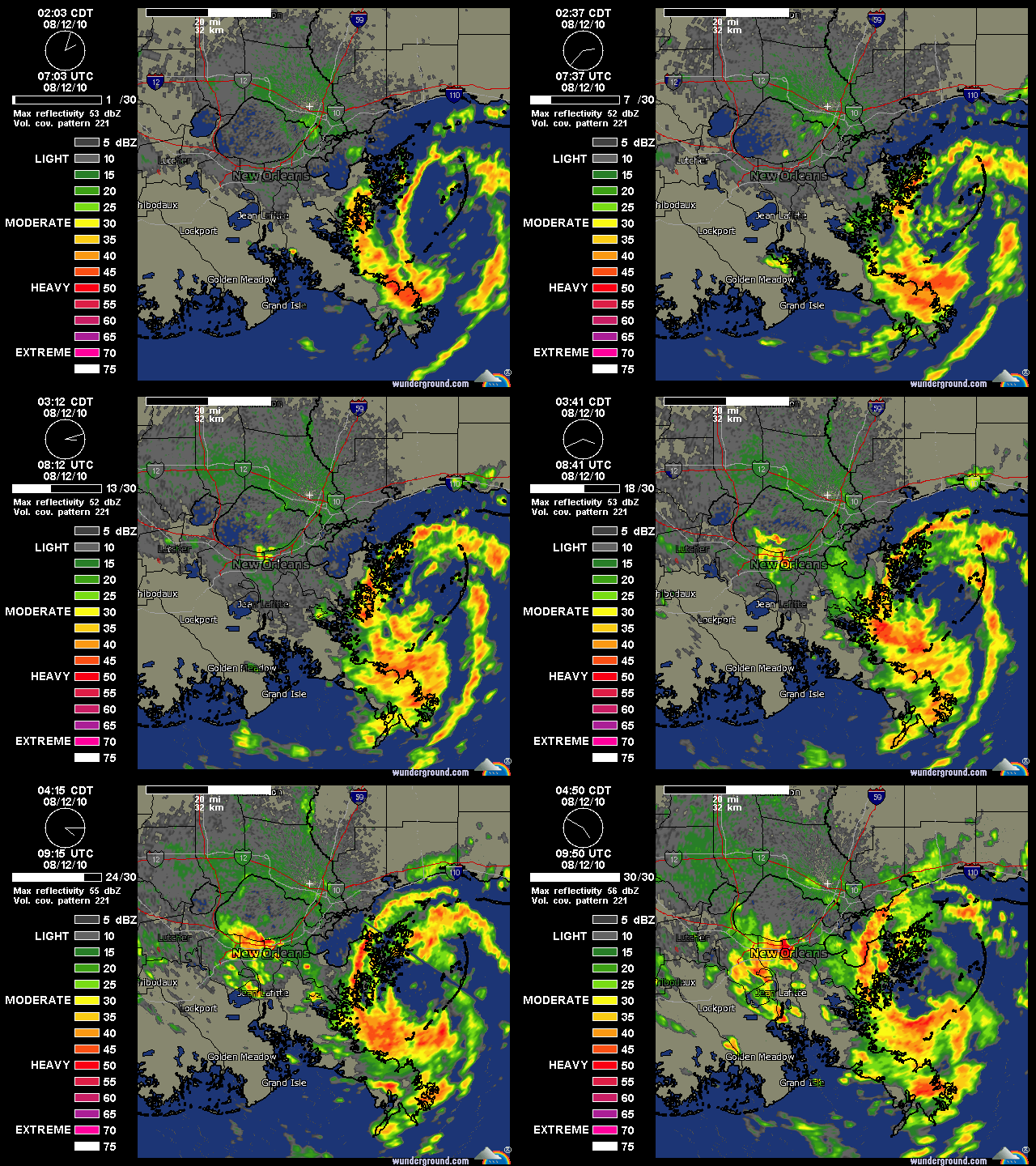
Radar loops from New Orleans earlier today would suggest that ex-05L organized into a tropical cyclone before landfall.


0 likes
- HURAKAN
- Professional-Met

- Posts: 46084
- Age: 39
- Joined: Thu May 20, 2004 4:34 pm
- Location: Key West, FL
- Contact:
Re: ATL: Ex Tropical Depression FIVE - Discussion
Looks good but winds don't support a tropical cyclone
0 likes
- MiamiHurricanes10
- S2K Supporter

- Posts: 260
- Joined: Mon Jul 19, 2010 7:56 pm
- Location: Miami, Florida
Re: ATL: Ex Tropical Depression FIVE - Discussion
HURAKAN wrote::uarrow:

Looks good but winds don't support a tropical cyclone
Structure-wise it matured into a tropical cyclone, however surface observations from around New Orleans never reported winds in excess of 25kt, so you're right...Structure of a TD, winds of a thunderstorm.
0 likes
-
Stormcenter
- S2K Supporter

- Posts: 6689
- Joined: Wed Sep 03, 2003 11:27 am
- Location: Houston, TX
Re: ATL: Ex Tropical Depression FIVE - Discussion
That is 100% correct.
It looked like a duck but didn't quack (winds) like one.
It looked like a duck but didn't quack (winds) like one.
HURAKAN wrote::uarrow:

Looks good but winds don't support a tropical cyclone
Last edited by Stormcenter on Thu Aug 12, 2010 11:26 am, edited 1 time in total.
0 likes
It's exactly what the remnants of Bonnie did, though Bonnie's winds were a little stronger. This one was buckets of rain (starting to pick up downtown in the city again, but not hard).
This was particularly weird:
>>Ex TD5 is looking better than when it was named.
I think it was the HWRF that indicated lower pressure and slight intensification post landfall (I haven't looked at any pressure readings). NAM actually had a decent looking system from 3-4 days out at the coast, but then it backed off. Then some of the globals wanted to stall a hair at landfall (then one of them, GFS I think) wanted to return the energy back to the Gulf. LMAO. Crazy. It got very close. Zoom of radar shows maybe the twist off of Shell Beach/Ysclosky area possibly headed for New Orleans East and the eastern side of Lake Pontchartrain. But it still looks like a circulation embedded into a broader circulation to me.
0 likes
http://www.hpc.ncep.noaa.gov/qpf/p120i12.gif
FWIW, QPF 5 day valid 12z has a lot of rain all along the Gulf Coast over toward Panama City Beach. Looking at the 12z NAM and 6Z GFS (12Z only out to 54 hours), it doesn't look like this energy is going to go anywhere anytime soon. 6z GFS looks to strengthen low pressure off the NW FL Coast and move it west again. Not sure if it's progression of the last pattern or if it's just trying to find something to do with the remnant energy, but I doubt any of us on the Gulf Coast will be complaining about the heat for the next several days if this verifies. 12Z obviously a bigger deal than the 6Z, so we'll have to wait and see what happens.
FWIW, QPF 5 day valid 12z has a lot of rain all along the Gulf Coast over toward Panama City Beach. Looking at the 12z NAM and 6Z GFS (12Z only out to 54 hours), it doesn't look like this energy is going to go anywhere anytime soon. 6z GFS looks to strengthen low pressure off the NW FL Coast and move it west again. Not sure if it's progression of the last pattern or if it's just trying to find something to do with the remnant energy, but I doubt any of us on the Gulf Coast will be complaining about the heat for the next several days if this verifies. 12Z obviously a bigger deal than the 6Z, so we'll have to wait and see what happens.
0 likes
Re: ATL: Ex Tropical Depression FIVE - Discussion
This thing isn't in any hurry to go anywhere... Winds at Shell Beach have been fluctuating between N and NW for the past 8 hours.
http://www.ndbc.noaa.gov/station_page.php?station=SHBL1
http://www.ndbc.noaa.gov/station_page.php?station=SHBL1
0 likes
Strange though. GFS 12Z is now out much further in time. It's hard to figure out what it's doing, but eventually it regenerates energy off of Mobile Bay and runs it west along the LA Coast over toward Vermillion/Cameron Parishes, then intensifies a bit before turning it due north south of Lake Charles as a reasonably potent system. I guess it's just something to watch for a while to see the pattern evolution.
http://www.nco.ncep.noaa.gov/pmb/nwprod ... loop.shtml
http://www.nco.ncep.noaa.gov/pmb/nwprod ... loop.shtml
0 likes
-
Dean4Storms
- S2K Supporter

- Posts: 6358
- Age: 63
- Joined: Sun Aug 31, 2003 1:01 pm
- Location: Miramar Bch. FL
We got another circulation now forming south of P'Cola Bch that is showing up on Radar.
http://radar.weather.gov/ridge/radar.ph ... 1&loop=yes
http://radar.weather.gov/ridge/radar.ph ... 1&loop=yes
0 likes
- ColinDelia
- S2K Supporter

- Posts: 918
- Joined: Mon Aug 29, 2005 5:52 am
- Location: The Beach, FL
Re: ATL: Ex Tropical Depression FIVE - Discussion
MiamiHurricanes10 wrote:Radar loops from New Orleans earlier today would suggest that ex-05L organized into a tropical cyclone before landfall.
Sure looked good on radar.
TD5 sure was an interesting storm from start to finish.
0 likes
-
Stormcenter
- S2K Supporter

- Posts: 6689
- Joined: Wed Sep 03, 2003 11:27 am
- Location: Houston, TX
I'm not sure what is going here but is bears watching as
long as it's close to the water. IMO
http://www.ssd.noaa.gov/goes/flt/t1/loop-vis.html
long as it's close to the water. IMO
http://www.ssd.noaa.gov/goes/flt/t1/loop-vis.html
0 likes
No kidding Dean. Multi-vortex system. Looks like on visible that an eddy or possibly the LLC is still stationary and kind of a naked swirl off of St. Bernard Parish if you zoom in on visible. Rain looks to be tapering off, but if it sits out there, could be another bursting round tonight (I'd put it at about 40/60).
http://www.ssd.noaa.gov/goes/flt/t1/flash-vis.html
http://www.ssd.noaa.gov/goes/flt/t1/flash-vis.html
0 likes
Oh and 12Z UKMET joining the chorus of some energy focusing around the Panhandle. These are a couple of maps (though I'm not sure if they'll translate via a link cut and paste - you may have to go to the University of Wyoming or other favorite weather site carrying the UKMET Model). FWIW, the reason I sought that model out was because of it's extrordinary forecast with Hurricane Ivan. Seeing something coming back around again worked once in a completely different scenario, but it was worth a look.
http://weather.uwyo.edu/cgi-bin/model?M ... ne&F2=p06i
http://weather.uwyo.edu/cgi-bin/model?M ... ne&F2=p06i
http://weather.uwyo.edu/cgi-bin/model?M ... ne&F2=p06i
http://weather.uwyo.edu/cgi-bin/model?M ... ne&F2=p06i
0 likes
- cycloneye
- Admin

- Posts: 149620
- Age: 69
- Joined: Thu Oct 10, 2002 10:54 am
- Location: San Juan, Puerto Rico
Re: ATL: Ex Tropical Depression FIVE - Discussion
TROPICAL WEATHER OUTLOOK
NWS TPC/NATIONAL HURRICANE CENTER MIAMI FL
200 PM EDT THU AUG 12 2010
FOR THE NORTH ATLANTIC...CARIBBEAN SEA AND THE GULF OF MEXICO...
THE BROAD AREA OF LOW PRESSURE ASSOCIATED WITH THE REMNANTS OF
TROPICAL DEPRESSION FIVE HAS MOVED LITTLE DURING THE PAST SEVERAL
HOURS AND REMAINS CENTERED NEAR THE SOUTHEASTERN LOUISIANA COAST.
THIS LOW WILL CONTINUE TO PRODUCE LOCALLY HEAVY RAINS AND
OCCASIONALLY GUSTY WINDS IN SQUALLS AS IT DRIFTS INLAND DURING THE
NEXT DAY OR SO. THERE IS A LOW CHANCE...NEAR 0 PERCENT...OF THIS
SYSTEM REDEVELOPING INTO A TROPICAL CYCLONE DURING THE NEXT 48
HOURS. LOCALIZED FLOODING IS POSSIBLE OVER SOUTHERN LOUISIANA AND
COASTAL MISSISSIPPI...PLEASE REFER TO STATEMENTS FROM LOCAL
NATIONAL WEATHER SERVICE FORECAST OFFICES FOR ADDITIONAL
INFORMATION.
ELSEWHERE...TROPICAL CYCLONE FORMATION IS NOT EXPECTED DURING THE
NEXT 48 HOURS.
$$
FORECASTER CANGIALOSI/AVILA
0 likes
Visit the Caribbean-Central America Weather Thread where you can find at first post web cams,radars
and observations from Caribbean basin members Click Here
and observations from Caribbean basin members Click Here
- jasons2k
- Storm2k Executive

- Posts: 8290
- Age: 52
- Joined: Wed Jul 06, 2005 12:32 pm
- Location: The Woodlands, TX
Re: ATL: Ex Tropical Depression FIVE - Discussion
HURAKAN wrote::uarrow:

Looks good but winds don't support a tropical cyclone
Is that wind speed or direction? Tropical Cyclones don't have a minimum wind speed criteria. If it is 39mph or greater, it is a TS. Anything less is a TD....and still a TC if is has a closed circulation and sustained deep convection.
0 likes
Re: ATL: Ex Tropical Depression FIVE - Discussion
Wow, you can clearly see the LLC spinning in this SAT loop. Doesn't appear to be moving and the heavy convection to the east is being drawn into it.
http://www.rap.ucar.edu/weather/satellite/displaySat.php?region=GOM&itype=vis&size=large&endDate=20100812&endTime=-1&duration=3
http://www.rap.ucar.edu/weather/satellite/displaySat.php?region=GOM&itype=vis&size=large&endDate=20100812&endTime=-1&duration=3
0 likes
Re: ATL: Ex Tropical Depression FIVE - Discussion
ronjon wrote:Wow, you can clearly see the LLC spinning in this SAT loop. Doesn't appear to be moving and the heavy convection to the east is being drawn into it.
http://www.rap.ucar.edu/weather/satellite/displaySat.php?region=GOM&itype=vis&size=large&endDate=20100812&endTime=-1&duration=3
You can see it on the radar too, seems to be moving NE.
http://radar.weather.gov/radar.php?rid=LIX&product=N0R&overlay=11101111&loop=yes
0 likes
- Ivanhater
- Storm2k Moderator

- Posts: 11221
- Age: 39
- Joined: Fri Jul 01, 2005 8:25 am
- Location: Pensacola
Re: ATL: Ex Tropical Depression FIVE - Discussion
Need to keep an eye on this with models showing it getting back in the gulf
0 likes
Michael
- Ivanhater
- Storm2k Moderator

- Posts: 11221
- Age: 39
- Joined: Fri Jul 01, 2005 8:25 am
- Location: Pensacola
Re: ATL: Ex Tropical Depression FIVE - Discussion
12z Euro is in line with the GFS sending this back in the Gulf


0 likes
Michael
Re: ATL: Ex Tropical Depression FIVE - Discussion
ronjon wrote:Wow, you can clearly see the LLC spinning in this SAT loop. Doesn't appear to be moving and the heavy convection to the east is being drawn into it.
http://www.rap.ucar.edu/weather/satellite/displaySat.php?region=GOM&itype=vis&size=large&endDate=20100812&endTime=-1&duration=3
The convection moving towards the LLC is due to easterly shear.

0 likes
Who is online
Users browsing this forum: No registered users and 72 guests


