ATL: HERMINE - Post-Tropical - Discussion
Moderator: S2k Moderators
Re: ATL: INVEST 99L - Discussion
People have been focusing on the MLC too much, this isn't going anywhere near Hispaniola. It'll be well clear north of PR by this afternoon. I'd even go so far to say the euro may shift a bit right (very small) this afternoon.
Last edited by BobHarlem on Wed Aug 24, 2016 8:27 am, edited 1 time in total.
1 likes
-
Weatherboy1

- Category 5

- Posts: 1190
- Age: 50
- Joined: Mon Jul 05, 2004 1:50 pm
- Location: Jupiter/Sarasota, FL
Re: ATL: INVEST 99L - Discussion
Steve wrote:BucMan2 wrote:Question: How significantly can land interaction change the center location or cause center reformation and
what effects if any could that have on the eventual track?
It depends. Sometimes it can help intensify (e.g. A perpendicularly landfalling storm in Texas). Other times it can rip a system apart ala mountains of Hispaniola or Mexico. A lot of times through the smaller islands, centers will want to stay over water and will hug or spin just off a coastline often going around even little jut outs. We are going to have to wait a few days to see what happens as it moves between where it is now and the Bahamas. To your question, there's no easy answer. Land interaction could do little, could influence the track some.
Personally, I do NOT believe that 99 is going to be wrestling with the high mountains in Hispanola. It looks like a clear shot to pass the island to the north, unlike some other developing systems from recent years. But considering the highest mountain there is just over 10,000 feet tall, that can (and has) disrupted or killed off many a storm in the past.
2 likes
-
Aric Dunn
- Category 5
- Posts: 21238
- Age: 43
- Joined: Sun Sep 19, 2004 9:58 pm
- Location: Ready for the Chase.
- Contact:
Re: ATL: INVEST 99L - Discussion
StormHunter72 wrote:Pro mets don't agree.Aric Dunn wrote:its been a TC since around 11pm last night est. was very evident. now we are going to have land interaction and the center is likely to jump around today...
the vocal one's dont lol.
0 likes
Note: If I make a post that is brief. Please refer back to previous posts for the analysis or reasoning. I do not re-write/qoute what my initial post said each time.
If there is nothing before... then just ask
Space & Atmospheric Physicist, Embry-Riddle Aeronautical University,
I believe the sky is falling...
If there is nothing before... then just ask
Space & Atmospheric Physicist, Embry-Riddle Aeronautical University,
I believe the sky is falling...
-
Tireman4

- S2K Supporter

- Posts: 5903
- Age: 60
- Joined: Fri Jun 30, 2006 1:08 pm
- Location: Humble, Texas
- Contact:
Re: ATL: INVEST 99L - Discussion
Wednesday morning briefing from Jeff:
Increasing rain chances Thursday-weekend
Tropical cyclone threat to the Gulf of Mexico next week.
Morning upper air analysis shows a strong upper ridge of high pressure in place from the SE US into SE TX with heights of around 597dm at LCH yesterday evening. This upper ridging help to limit rain chances yesterday and will do so again today, but will begin to break down over TX starting Thursday…and how very important this high pressure feature will be in the coming week with respect to the track of 99L.
Tropical moisture will make a return to the region starting Thursday and expect to see afternoon showers and thunderstorms both days with rain chances of 40-50%. Heating and seabreeze will make for the most activity. Storm motions not looking all that fast so a few areas could see some heavy rainfall rates. Will keep rain chances going into the weekend as disturbances slide west under the ridge of high pressure over the SE US and moisture remains high.
99L:
Concern is growing that a tropical cyclone will move into the Gulf of Mexico late this weekend
99L this morning is over the northern Leeward Islands and while the system looks impressive on satellite images, surface observations show an ill defined surface low pressure system associated with the feature. The Barbados sounding yesterday evening showed two layers of dry air that are likely impacting the wave and helping to mitigate development in the near term. 99L is moving toward the WNW at 15-20mph and this motion is expected to continue bringing the wave across Puerto Rico Thursday and into the SE Bahamas Friday.
Track:
Much of the future track of this system will hinge on the large scale high pressure ridge over the SE US including how strong this feature is, how expansive, and where it is centered. Once in the south/central Bahamas, 99L will begin to feel the large scale high pressure centered near the Carolinas this weekend and will be forced to turn toward the west or even WSW approaching S FL or the keys. Effectively it appears that the door is closed on chances for the system to turn northward and recurve east of the US coast…this suggests a landfalling tropical system is increasingly likely on the US Gulf coast next week.
The next big question, once in the Gulf of Mexico which seems likely at this point, how far west does the system move before turning toward the NW and N and rounding the western edge of the Carolinas high pressure ridge. Global model ensemble support from the CMC, GFS, and ECMWF have all trended westward in the last 36 hours now showing a clustering well into the central Gulf of Mexico and potentially the central US Gulf coast. Operational model runs of these models have been all over the place with widely varied solutions of both track and intensity…but there is starting to be some growing consensus that the US Gulf coast is at threat.
The biggest aspect of the model guidance at this time is the westward trend and general overall placement and intensity of the large scale ridging over the SE US this weekend into early next week. One should not focus on the individual runs of each model, but their 500mb ridge pattern and their respective ensemble plots. Additionally models will continue to struggle until a define low level center develops and the development of this center could be many miles off of where current guidance is suggesting it will form due to the current poor organization of the wave.
Intensity:
Conditions will gradually become increasingly favorable for development as 99L moves toward the Bahamas this weekend. While there are a few factors in/near the Bahamas that could restrict development, the overall pattern appears favorable including generally light wind shear, high moisture levels within where the vortex should be located and very warm waters. This is where model support increases for development. As the system moves into the Gulf of Mexico conditions look ideal for development of a potentially significant tropical cyclone. An upper level 200mb high pressure cell (anti-cyclone) appears to encompass much of the central and eastern Gulf of Mexico with a westward moving upper level trough over MX/SW TX which could help with the upper level outflow and venting of a developing system. Sea surface temperatures are very warm…running in the mid 80’s and moisture looks plentiful. There appears to be little to stop intensification once in the Gulf of Mexico and the last 3 operational runs of the ECMWF have all shown significant growth over the Gulf.
Residents along the entire US Gulf coast and FL should closely monitor the progress of this system.
Review hurricane preparedness plans and be fully ready to enact these plans by late this weekend.
1 likes
-
ScottNAtlanta

- Category 5
- Posts: 2535
- Joined: Sat May 25, 2013 3:11 pm
- Location: Atlanta, GA
Re: ATL: INVEST 99L - Discussion
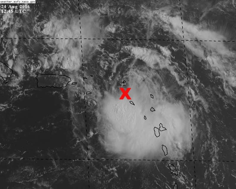
NDG wrote:This is where I see the LLC. IMO.
Moderate to strong shear to its north, it will have a tough time north of P.R. & Hispaniola until the shear subsides.
http://i20.photobucket.com/albums/b245/ ... xcjinj.jpg
I agree. The center is on the north end. Shear is a factor, but I dont think this goes into Hispaniola. The thing to watch for is when the wnw to nw movement turns west. That will be the point where its beat any hostile conditions and should ramp up rather quickly. When these storms make that left hook they almost always blow up.
Last edited by Ntxw on Wed Aug 24, 2016 8:57 am, edited 1 time in total.
Reason: Removed img tags
Reason: Removed img tags
0 likes
The posts in this forum are NOT official forecast and should not be used as such. They are just the opinion of the poster and may or may not be backed by sound meteorological data. They are NOT endorsed by any professional institution or storm2k.org. For official information, please refer to the NHC and NWS products.
-
SouthFLTropics

- Category 5
- Posts: 4258
- Age: 50
- Joined: Thu Aug 14, 2003 8:04 am
- Location: Port St. Lucie, Florida
Re: ATL: INVEST 99L - Discussion
Weatherboy1 wrote:Steve wrote:BucMan2 wrote:Question: How significantly can land interaction change the center location or cause center reformation and
what effects if any could that have on the eventual track?
It depends. Sometimes it can help intensify (e.g. A perpendicularly landfalling storm in Texas). Other times it can rip a system apart ala mountains of Hispaniola or Mexico. A lot of times through the smaller islands, centers will want to stay over water and will hug or spin just off a coastline often going around even little jut outs. We are going to have to wait a few days to see what happens as it moves between where it is now and the Bahamas. To your question, there's no easy answer. Land interaction could do little, could influence the track some.
Personally, I do NOT believe that 99 is going to be wrestling with the high mountains in Hispanola. It looks like a clear shot to pass the island to the north, unlike some other developing systems from recent years. But considering the highest mountain there is just over 10,000 feet tall, that can (and has) disrupted or killed off many a storm in the past.
Even if it doesn't cross Hispaniola directly, the large mountains could restrict the inflow from the South potentially causing some issues with development. However, we have seen cases before where land interaction actually helps a developing systems inner core tighten up. As long as the LLC clears to the North it should have no issues.
1 likes
Fourth Generation Florida Native
Personal Storm History: David 79, Andrew 92, Erin 95, Floyd 99, Irene 99, Frances 04, Jeanne 04, Wilma 05, Matthew 16, Irma 17, Ian 22, Nicole 22, Milton 24
Personal Storm History: David 79, Andrew 92, Erin 95, Floyd 99, Irene 99, Frances 04, Jeanne 04, Wilma 05, Matthew 16, Irma 17, Ian 22, Nicole 22, Milton 24
-
Aric Dunn
- Category 5
- Posts: 21238
- Age: 43
- Joined: Sun Sep 19, 2004 9:58 pm
- Location: Ready for the Chase.
- Contact:
Re: ATL: INVEST 99L - Discussion
its pretty much exactly where the hwrf had it by this morning. its now exposed and heading towards the NE tip of PR looks like it will miss it though.
0 likes
Note: If I make a post that is brief. Please refer back to previous posts for the analysis or reasoning. I do not re-write/qoute what my initial post said each time.
If there is nothing before... then just ask
Space & Atmospheric Physicist, Embry-Riddle Aeronautical University,
I believe the sky is falling...
If there is nothing before... then just ask
Space & Atmospheric Physicist, Embry-Riddle Aeronautical University,
I believe the sky is falling...
-
Nederlander
- S2K Supporter
- Posts: 1259
- Joined: Sat Jul 19, 2008 4:28 pm
- Location: Conroe, TX
Re: ATL: INVEST 99L - Discussion
SoupBone wrote:Are any models hinting at all about a slowdown? I know a few had it actually moving faster, but if it were to significantly slow down, are there any indications that the ridge could degrade allowing for a small window of opportunity to head north? I'm not suggesting out to sea at all, but a more northern run toward the panhandle or Jacksonville.
The ridge is parked over the SE CONUS for the next couple of days.. Then it slightly shifts east preventing any recurve scenario.. I don't see JAX in play here due to that ridge in place and shifting to the east. Should steer 99L west at that point as models suggest.
0 likes
-
znel52
Re: ATL: INVEST 99L - Discussion
BobHarlem wrote:People have been focusing on the MLC too much, this isn't going anywhere near Hispaniola. It'll be well clear north of PR by this afternoon. I'd even go so far to say the euro may shift a bit right (very small) this afternoon.
Agreed people are focusing on the MLC. The circulation they should be looking at is now easily visible on satellite loops. It is due East of Puerto Rico so unless is starts moving due West land interaction shouldn't be a problem.
http://weather.msfc.nasa.gov/cgi-bin/ge ... mframes=15
0 likes

Re: ATL: INVEST 99L - Discussion
So we can see the low level circulation is still elongated?
Think I'll wait for recon, with an updated surface pressure profile maybe we can guess a little better..
Think I'll wait for recon, with an updated surface pressure profile maybe we can guess a little better..
Last edited by Nimbus on Wed Aug 24, 2016 8:35 am, edited 1 time in total.
0 likes
-
Blown Away

- S2K Supporter
- Posts: 10253
- Joined: Wed May 26, 2004 6:17 am
Re: ATL: INVEST 99L - Discussion

0 likes
Hurricane Eye Experience: David 79, Irene 99, Frances 04, Jeanne 04, Wilma 05… Hurricane Brush Experience: Andrew 92, Erin 95, Floyd 99, Matthew 16, Irma 17, Ian 22, Nicole 22…
-
Aric Dunn
- Category 5
- Posts: 21238
- Age: 43
- Joined: Sun Sep 19, 2004 9:58 pm
- Location: Ready for the Chase.
- Contact:
Re: ATL: INVEST 99L - Discussion
pretty evident where it is. even if some want to say its a vort in which case there is likely another in there somewhere rotating around... this would still mean we have a west wind and well a TC which was very clear last night around 10 pm to 12 am through the rest of the night and still now. It is exposed as the low level flow is pretty fast at the moment. once north of PR it could have a chance to organize some more.

1 likes
Note: If I make a post that is brief. Please refer back to previous posts for the analysis or reasoning. I do not re-write/qoute what my initial post said each time.
If there is nothing before... then just ask
Space & Atmospheric Physicist, Embry-Riddle Aeronautical University,
I believe the sky is falling...
If there is nothing before... then just ask
Space & Atmospheric Physicist, Embry-Riddle Aeronautical University,
I believe the sky is falling...

Re: ATL: INVEST 99L - Discussion
Weatherboy1 wrote:Steve wrote:BucMan2 wrote:Question: How significantly can land interaction change the center location or cause center reformation and
what effects if any could that have on the eventual track?
It depends. Sometimes it can help intensify (e.g. A perpendicularly landfalling storm in Texas). Other times it can rip a system apart ala mountains of Hispaniola or Mexico. A lot of times through the smaller islands, centers will want to stay over water and will hug or spin just off a coastline often going around even little jut outs. We are going to have to wait a few days to see what happens as it moves between where it is now and the Bahamas. To your question, there's no easy answer. Land interaction could do little, could influence the track some.
Personally, I do NOT believe that 99 is going to be wrestling with the high mountains in Hispanola. It looks like a clear shot to pass the island to the north, unlike some other developing systems from recent years. But considering the highest mountain there is just over 10,000 feet tall, that can (and has) disrupted or killed off many a storm in the past.
I agree with that for the most part. What you're saying is basically with a defined circulation center in the lower levels, they can't spin through mountains because it's composed of moving air and water vapor which obviously can't penetrate through mountains. I also neglected to mention above that sometimes (though not usually with the small islands, more with the US Coast, land can impart dry/hot continental air into a system. You might recall Hurricane Isaac in 2010. The reason New Orleans didn't pay the big price for that one was because like 80% of northern semi-circle was dry. The circulation still had clouds and wind, but we had very little rain before the center got close to shore. That was the first test of the newer levee system (which btw are still only designed for a fast moving Category 3 here). Any Cat 4 or 5 or any massive storm surge from a lower-cat storm (Katrina) would still inundate the city.
0 likes
-
Aric Dunn
- Category 5
- Posts: 21238
- Age: 43
- Joined: Sun Sep 19, 2004 9:58 pm
- Location: Ready for the Chase.
- Contact:
Re: ATL: INVEST 99L - Discussion
well at least recon wont have to fly far.. they can just take off and be there right away....or go outside and do a direct reading lol
1 likes
Note: If I make a post that is brief. Please refer back to previous posts for the analysis or reasoning. I do not re-write/qoute what my initial post said each time.
If there is nothing before... then just ask
Space & Atmospheric Physicist, Embry-Riddle Aeronautical University,
I believe the sky is falling...
If there is nothing before... then just ask
Space & Atmospheric Physicist, Embry-Riddle Aeronautical University,
I believe the sky is falling...
-
ScottNAtlanta
- Category 5
- Posts: 2535
- Joined: Sat May 25, 2013 3:11 pm
- Location: Atlanta, GA
Re: ATL: INVEST 99L - Discussion
what time do they take off?
0 likes
The posts in this forum are NOT official forecast and should not be used as such. They are just the opinion of the poster and may or may not be backed by sound meteorological data. They are NOT endorsed by any professional institution or storm2k.org. For official information, please refer to the NHC and NWS products.

Re: ATL: INVEST 99L - Discussion
ScottNAtlanta wrote:what time do they take off?
11am EDT I believe.
1 likes
Personal Forecast Disclaimer:
The posts in this forum are NOT official forecast and should not be used as such. They are just the opinion of the poster and may or may not be backed by sound meteorological data. They are NOT endorsed by any professional institution or storm2k.org. For official information, please refer to the NHC and NWS products.
The posts in this forum are NOT official forecast and should not be used as such. They are just the opinion of the poster and may or may not be backed by sound meteorological data. They are NOT endorsed by any professional institution or storm2k.org. For official information, please refer to the NHC and NWS products.
-
gatorcane

- S2K Supporter
- Posts: 23708
- Age: 48
- Joined: Sun Mar 13, 2005 3:54 pm
- Location: Boca Raton, FL
Re: ATL: INVEST 99L - Discussion
Yeah I agree with you all where the LLC is, it is exposed and moving WNW and I think it could miss Hispaniola to the north if it keeps this heading. Vorticity is increasing as predicted by the ECMWF. The structure looks good so it seems if the shear lets up at some point in the next few days, this could take off.
The posts in this forum are NOT official forecasts and should not be used as such. They are just the opinion of the poster and may or may not be backed by sound meteorological data. They are NOT endorsed by any professional institution or STORM2K. For official information, please refer to products from the NHC and NWS.
Last edited by gatorcane on Wed Aug 24, 2016 8:40 am, edited 1 time in total.
0 likes
Re: ATL: INVEST 99L - Discussion
Classic case of "where the convection is" confusing some people. If you're looking at what would appear to be the main ball of convection, you could be forgiven for thinking it's tracking well into the Caribbean, south of PR and Hispaniola.
0 likes
-
ScottNAtlanta
- Category 5
- Posts: 2535
- Joined: Sat May 25, 2013 3:11 pm
- Location: Atlanta, GA
Re: ATL: INVEST 99L - Discussion
This should be in the range of San Juan radar here shortly
http://radar.weather.gov/radar.php?prod ... A&loop=yes
http://radar.weather.gov/radar.php?prod ... A&loop=yes
0 likes
The posts in this forum are NOT official forecast and should not be used as such. They are just the opinion of the poster and may or may not be backed by sound meteorological data. They are NOT endorsed by any professional institution or storm2k.org. For official information, please refer to the NHC and NWS products.
-
Frank P
- S2K Supporter
- Posts: 2779
- Joined: Fri Aug 29, 2003 10:52 am
- Location: Biloxi Beach, Ms
- Contact:
Re: ATL: INVEST 99L - Discussion
The LLC as pointed out by Aric Dunn and others certainly appears to be moving at a WNW clip as indicated by the few vis sat loops currently available...
0 likes
Who is online
Users browsing this forum: No registered users and 35 guests