
https://twitter.com/dmorris9661/status/1694162657375399952
https://twitter.com/dmorris9661/status/1694162658939879451
2023 Global Model Runs Discussion (Out thru day 16)
Moderator: S2k Moderators
Forum rules

The posts in this forum are NOT official forecasts and should not be used as such. They are just the opinion of the poster and may or may not be backed by sound meteorological data. They are NOT endorsed by any professional institution or STORM2K. For official information, please refer to products from the National Hurricane Center and National Weather Service.
Re: 2023 Global Model Runs Discussion (Out thru day 16)
2 likes
TC naming lists: retirements and intensity
Most aggressive Advisory #1's in North Atlantic (cr. kevin for starting the list)
Most aggressive Advisory #1's in North Atlantic (cr. kevin for starting the list)
-
Blown Away

- S2K Supporter

- Posts: 10253
- Joined: Wed May 26, 2004 6:17 am
Re: 2023 Global Model Runs Discussion (Out thru day 16)
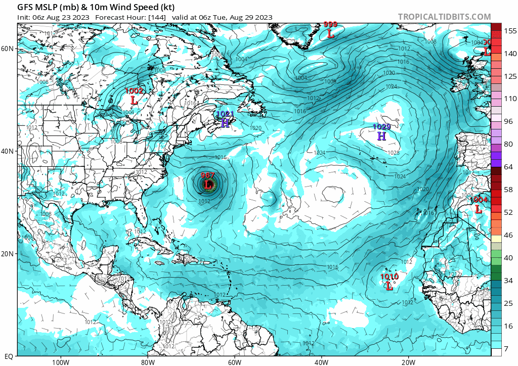
06z GFS
1 likes
Hurricane Eye Experience: David 79, Irene 99, Frances 04, Jeanne 04, Wilma 05… Hurricane Brush Experience: Andrew 92, Erin 95, Floyd 99, Matthew 16, Irma 17, Ian 22, Nicole 22…

Re: 2023 Global Model Runs Discussion (Out thru day 16)
BobHarlem wrote:SouthFLTropics wrote:Surprised no one has posted the 00z CMC. Sends a 979mb storm right up Tampa Bay in 168 hours. Looks to develop from the EPac crossover.
This is just 7 days out, 12z run had something near here too, just not anywhere near as organized. GFS does have something move over central america but it remains disorganized too. 12Z euro also had something around here in a week. I guess this will be the area to watch over the next few days for damn sure (besides Franklin and Bermuda) Models really depend on how/where this pops out at on the Atlantic side. West Caribbean here in the Canadian. GFS destroys it over Central America and never really recovers it, Euro is somewhere in between. (18z has it in over Belize)
I.e. watch this on Friday.
https://i.imgur.com/AH28yTo.png
Well if you look at the hurricane parent models they show a tropical storm brewing up near Cuba that's heading to Florida.

1 likes
-
SFLcane

- S2K Supporter
- Posts: 10281
- Age: 48
- Joined: Sat Jun 05, 2010 1:44 pm
- Location: Lake Worth Florida
Re: 2023 Global Model Runs Discussion (Out thru day 16)
ChrisH-UK wrote:BobHarlem wrote:SouthFLTropics wrote:Surprised no one has posted the 00z CMC. Sends a 979mb storm right up Tampa Bay in 168 hours. Looks to develop from the EPac crossover.
This is just 7 days out, 12z run had something near here too, just not anywhere near as organized. GFS does have something move over central america but it remains disorganized too. 12Z euro also had something around here in a week. I guess this will be the area to watch over the next few days for damn sure (besides Franklin and Bermuda) Models really depend on how/where this pops out at on the Atlantic side. West Caribbean here in the Canadian. GFS destroys it over Central America and never really recovers it, Euro is somewhere in between. (18z has it in over Belize)
I.e. watch this on Friday.
https://i.imgur.com/AH28yTo.png
Well if you look at the hurricane parent models they show a tropical storm brewing up near Cuba that's heading to Florida.
[url]https://imagizer.imageshack.com/v2/800x600q70/922/0F0GQU.png [/url]
I would not rely on that unless other global models are showing it.
0 likes
-
SFLcane
- S2K Supporter
- Posts: 10281
- Age: 48
- Joined: Sat Jun 05, 2010 1:44 pm
- Location: Lake Worth Florida
Re: 2023 Global Model Runs Discussion (Out thru day 16)
Just saying...
It's really something to see the models show an Mdr hurricane and next run it’s gone. Glad I didn’t renew my weathermodels subscription I can watch that on tidbits certainly isn’t worth my $. Those waves on the 06z gfs already moving nw midway in the Mdr. Bet it’s gone at 12z. 0 consistency this year with anything. Surely things can still turn around but for now thats what i see.
It's really something to see the models show an Mdr hurricane and next run it’s gone. Glad I didn’t renew my weathermodels subscription I can watch that on tidbits certainly isn’t worth my $. Those waves on the 06z gfs already moving nw midway in the Mdr. Bet it’s gone at 12z. 0 consistency this year with anything. Surely things can still turn around but for now thats what i see.
Last edited by SFLcane on Wed Aug 23, 2023 8:34 am, edited 2 times in total.
1 likes
-
toad strangler

- S2K Supporter
- Posts: 4546
- Joined: Sun Jul 28, 2013 3:09 pm
- Location: Earth
- Contact:
Re: 2023 Global Model Runs Discussion (Out thru day 16)
SFLcane wrote:Jus saying...
It's really something to see the models show an Mdr hurricane and next run it’s gone. Glad I didn’t renew my weathermodels subscription I can watch that on tidbits certainly isn’t worth my $. Those waves on the 06z gfs already moving nw midway in the Mdr. Bet it’s gone at 12z. 0 consistency this year with anything.
And some say modeling has come a long way the past decade or so
0 likes
My Weather Station
https://www.wunderground.com/dashboard/pws/KFLPORTS603
https://www.wunderground.com/dashboard/pws/KFLPORTS603

Re: 2023 Global Model Runs Discussion (Out thru day 16)
toad strangler wrote:SFLcane wrote:Jus saying...
It's really something to see the models show an Mdr hurricane and next run it’s gone. Glad I didn’t renew my weathermodels subscription I can watch that on tidbits certainly isn’t worth my $. Those waves on the 06z gfs already moving nw midway in the Mdr. Bet it’s gone at 12z. 0 consistency this year with anything.
And some say modeling has come a long way the past decade or soI don't think so. What has come a long way are the humans at the NHC and elsewhere around the pro weather campus.
While I agree that people are better, models have gotten much better in the last 10 years and even way better than that going backwards. I read something a while back that said that a 5 day forecast was about as good as tomorrow's was in 1980. Also hurricane track guidance and intensity have greatly improved. We have more data, better tools and more super computers. That's all I'm saying. I still don't think the models are good enough with genesis or anything and often miss things that seem obvious to observers.
Yesterday's JMA (scroll over JMAN) skirted the circle at 1-2-3. https://www.cpc.ncep.noaa.gov/products/ ... r_wh.shtml
Its' the only model really doing that as many of the others cut across the circle and head back for 6-7 which are not favorable Western Atlantic phases.
2 likes
-
jasons2k

- Storm2k Executive

- Posts: 8290
- Age: 52
- Joined: Wed Jul 06, 2005 12:32 pm
- Location: The Woodlands, TX
Re: 2023 Global Model Runs Discussion (Out thru day 16)
Friendly reminder that model verification is easy to numerically verify so be careful with opinions about how well they have or haven’t performed. If you’re wrong, someone will pull the data and show it.
1 likes
-
toad strangler
- S2K Supporter
- Posts: 4546
- Joined: Sun Jul 28, 2013 3:09 pm
- Location: Earth
- Contact:
Re: 2023 Global Model Runs Discussion (Out thru day 16)
jasons2k wrote:Friendly reminder that model verification is easy to numerically verify so be careful with opinions about how well they have or haven’t performed. If you’re wrong, someone will pull the data and show it.
That's fair, but in regards to tropical genesis I think modeling has a long way to go. A LONG way. Once storms are actually on the table my comment would easily be refuted for sure.
3 likes
My Weather Station
https://www.wunderground.com/dashboard/pws/KFLPORTS603
https://www.wunderground.com/dashboard/pws/KFLPORTS603
-
cheezyWXguy

- Category 5

- Posts: 6282
- Joined: Mon Feb 13, 2006 12:29 am
- Location: Dallas, TX
Re: 2023 Global Model Runs Discussion (Out thru day 16)
Steve wrote:toad strangler wrote:SFLcane wrote:Jus saying...
It's really something to see the models show an Mdr hurricane and next run it’s gone. Glad I didn’t renew my weathermodels subscription I can watch that on tidbits certainly isn’t worth my $. Those waves on the 06z gfs already moving nw midway in the Mdr. Bet it’s gone at 12z. 0 consistency this year with anything.
And some say modeling has come a long way the past decade or so
While I agree that people are better, models have gotten much better in the last 10 years and even way better than that going backwards. I read something a while back that said that a 5 day forecast was about as good as tomorrow's was in 1980. Also hurricane track guidance and intensity have greatly improved. We have more data, better tools and more super computers. That's all I'm saying. I still don't think the models are good enough with genesis or anything and often miss things that seem obvious to observers.
Yesterday's JMA (scroll over JMAN) skirted the circle at 1-2-3. https://www.cpc.ncep.noaa.gov/products/ ... r_wh.shtml
Its' the only model really doing that as many of the others cut across the circle and head back for 6-7 which are not favorable Western Atlantic phases.
This is a great point. We have a ton more data being fed into these models than we did 10 years ago, more variables being accounted for, and all at ever-increasing resolution. This increases the potential for accuracy and precision, but also increases the number of opportunities for compounding errors. The models have made great strides since I first started paying attention to them 15 years ago or so, but we are still a long way away from reliable human-free forecasting in a lot of contexts
1 likes
Re: 2023 Global Model Runs Discussion (Out thru day 16)
cheezyWXguy wrote:Steve wrote:toad strangler wrote:
And some say modeling has come a long way the past decade or so
While I agree that people are better, models have gotten much better in the last 10 years and even way better than that going backwards. I read something a while back that said that a 5 day forecast was about as good as tomorrow's was in 1980. Also hurricane track guidance and intensity have greatly improved. We have more data, better tools and more super computers. That's all I'm saying. I still don't think the models are good enough with genesis or anything and often miss things that seem obvious to observers.
Yesterday's JMA (scroll over JMAN) skirted the circle at 1-2-3. https://www.cpc.ncep.noaa.gov/products/ ... r_wh.shtml
Its' the only model really doing that as many of the others cut across the circle and head back for 6-7 which are not favorable Western Atlantic phases.
This is a great point. We have a ton more data being fed into these models than we did 10 years ago, more variables being accounted for, and all at ever-increasing resolution. This increases the potential for accuracy and precision, but also increases the number of opportunities for compounding errors. The models have made great strides since I first started paying attention to them 15 years ago or so, but we are still a long way away from reliable human-free forecasting in a lot of contexts
Yeah. They still use the "clipper" model because it has some statistical value over blind luck. But it's pretty bad. The NAVGEM which I think was an upgrade from the old Navy Nogaps model is also pretty bad. I barely even look at it anymore when running models I want to see (EC, UK, CMC, GFS, RAP, FV3, CFS, etc.). I'm on about 25-30 years of watching them, and though we aren't where we want to be (particularly with genesis as Toad mentioned), it's a long way from the WRF, MRF, AVN (think maybe became the NAM?) and some of the ones that got replaced or upgraded over the years.
1 likes
-
jasons2k
- Storm2k Executive
- Posts: 8290
- Age: 52
- Joined: Wed Jul 06, 2005 12:32 pm
- Location: The Woodlands, TX
Re: 2023 Global Model Runs Discussion (Out thru day 16)
Oh wow I haven’t seen some of those acronyms in so long.
I remember awing at GFDL handling Katrina moving into then WSW across the Everglades - while strengthening - and thinking it was the model of the future.
Yes, we have come a long ways. Even with genesis. Models are much better now at sniffing-out medium-long range legitimate threats than they used to be. But you still have to reconcile the storms with the overall pattern and question if it even makes sense to start with. That aspect never changes…
4 likes
-
cheezyWXguy
- Category 5
- Posts: 6282
- Joined: Mon Feb 13, 2006 12:29 am
- Location: Dallas, TX
Re: 2023 Global Model Runs Discussion (Out thru day 16)
Steve wrote:cheezyWXguy wrote:Steve wrote:
While I agree that people are better, models have gotten much better in the last 10 years and even way better than that going backwards. I read something a while back that said that a 5 day forecast was about as good as tomorrow's was in 1980. Also hurricane track guidance and intensity have greatly improved. We have more data, better tools and more super computers. That's all I'm saying. I still don't think the models are good enough with genesis or anything and often miss things that seem obvious to observers.
Yesterday's JMA (scroll over JMAN) skirted the circle at 1-2-3. https://www.cpc.ncep.noaa.gov/products/ ... r_wh.shtml
Its' the only model really doing that as many of the others cut across the circle and head back for 6-7 which are not favorable Western Atlantic phases.
This is a great point. We have a ton more data being fed into these models than we did 10 years ago, more variables being accounted for, and all at ever-increasing resolution. This increases the potential for accuracy and precision, but also increases the number of opportunities for compounding errors. The models have made great strides since I first started paying attention to them 15 years ago or so, but we are still a long way away from reliable human-free forecasting in a lot of contexts
Yeah. They still use the "clipper" model because it has some statistical value over blind luck. But it's pretty bad. The NAVGEM which I think was an upgrade from the old Navy Nogaps model is also pretty bad. I barely even look at it anymore when running models I want to see (EC, UK, CMC, GFS, RAP, FV3, CFS, etc.). I'm on about 25-30 years of watching them, and though we aren't where we want to be (particularly with genesis as Toad mentioned), it's a long way from the WRF, MRF, AVN (think maybe became the NAM?) and some of the ones that got replaced or upgraded over the years.
Ha, I still remember the days of either wxman or one of the other early pro Mets referring to the NGM as the “No-Good Model”
1 likes
-
SouthFLTropics

- Category 5
- Posts: 4258
- Age: 50
- Joined: Thu Aug 14, 2003 8:04 am
- Location: Port St. Lucie, Florida
Re: 2023 Global Model Runs Discussion (Out thru day 16)
Meanwhile, the 12z Icon and CMC once again show development approaching the SW Florida coast by early next week. I think the area around Belize and the Yucatan is going to need a bear watch over the next few days.
0 likes
Fourth Generation Florida Native
Personal Storm History: David 79, Andrew 92, Erin 95, Floyd 99, Irene 99, Frances 04, Jeanne 04, Wilma 05, Matthew 16, Irma 17, Ian 22, Nicole 22, Milton 24
Personal Storm History: David 79, Andrew 92, Erin 95, Floyd 99, Irene 99, Frances 04, Jeanne 04, Wilma 05, Matthew 16, Irma 17, Ian 22, Nicole 22, Milton 24
-
jasons2k
- Storm2k Executive
- Posts: 8290
- Age: 52
- Joined: Wed Jul 06, 2005 12:32 pm
- Location: The Woodlands, TX
Re: 2023 Global Model Runs Discussion (Out thru day 16)
SouthFLTropics wrote:Meanwhile, the 12z Icon and CMC once again show development approaching the SW Florida coast by early next week. I think the area around Belize and the Yucatan is going to need a bear watch over the next few days.
Levi Cowan talked about this in his video update yesterday.
0 likes

Re: 2023 Global Model Runs Discussion (Out thru day 16)
SouthFLTropics wrote:Meanwhile, the 12z Icon and CMC once again show development approaching the SW Florida coast by early next week. I think the area around Belize and the Yucatan is going to need a bear watch over the next few days.
Same location and time frame, definitely something to keep an eye on. Seems to be a good amount of shear in that area which should keep it from intensifying too much but that's always a sneaky area for development
0 likes
-
SFLcane
- S2K Supporter
- Posts: 10281
- Age: 48
- Joined: Sat Jun 05, 2010 1:44 pm
- Location: Lake Worth Florida
Re: 2023 Global Model Runs Discussion (Out thru day 16)
SouthFLTropics wrote:Meanwhile, the 12z Icon and CMC once again show development approaching the SW Florida coast by early next week. I think the area around Belize and the Yucatan is going to need a bear watch over the next few days.
Decent signal for sure
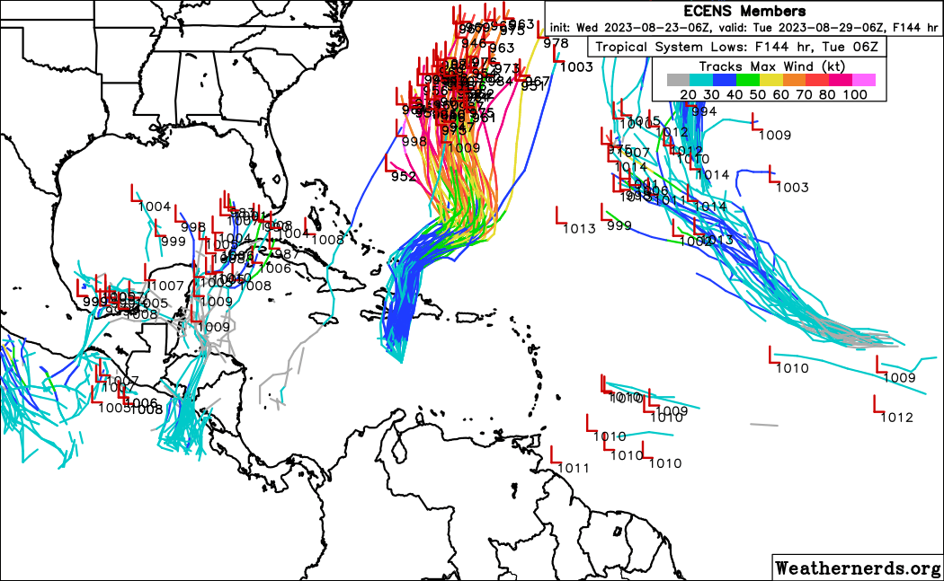
06z eps
0 likes
-
cycloneye

- Admin
- Posts: 149714
- Age: 69
- Joined: Thu Oct 10, 2002 10:54 am
- Location: San Juan, Puerto Rico
Re: 2023 Global Model Runs Discussion (Out thru day 16)
12z CMC has a MDR rider (Not 92L) and also has the Yucatán area.

0 likes
Visit the Caribbean-Central America Weather Thread where you can find at first post web cams,radars
and observations from Caribbean basin members Click Here
and observations from Caribbean basin members Click Here

Re: 2023 Global Model Runs Discussion (Out thru day 16)
jfk08c wrote:SouthFLTropics wrote:Meanwhile, the 12z Icon and CMC once again show development approaching the SW Florida coast by early next week. I think the area around Belize and the Yucatan is going to need a bear watch over the next few days.
Same location and time frame, definitely something to keep an eye on. Seems to be a good amount of shear in that area which should keep it from intensifying too much but that's always a sneaky area for development
Yea. Models had it up to a cat2 a couple days ago. It will be a small system too but look how Charley ramped up and the waters are warming back up again now after cooling a bit. IMO we see mid range cat1 just due to the warm waters but wouldn't be shocked to see a cat2 from Tampa on South. However even just a cat1 or 2 will set back recovery efforts even just 6 foot of surge over those areas.
Could be as early as Tue this hits so not a lot of time. You would think NHC highlights that area any time now since it's well within 7 days if it starts to form.
0 likes
-
SouthFLTropics
- Category 5
- Posts: 4258
- Age: 50
- Joined: Thu Aug 14, 2003 8:04 am
- Location: Port St. Lucie, Florida
Re: 2023 Global Model Runs Discussion (Out thru day 16)
Euro is jumping onboard the Yucatan disturbance. Think we may have a player for Florida. And unfortunately, it will most likely get the dreaded "I" name. Hopefully the curse of that letter storm can be broken, and this just stay weak.
0 likes
Fourth Generation Florida Native
Personal Storm History: David 79, Andrew 92, Erin 95, Floyd 99, Irene 99, Frances 04, Jeanne 04, Wilma 05, Matthew 16, Irma 17, Ian 22, Nicole 22, Milton 24
Personal Storm History: David 79, Andrew 92, Erin 95, Floyd 99, Irene 99, Frances 04, Jeanne 04, Wilma 05, Matthew 16, Irma 17, Ian 22, Nicole 22, Milton 24
Who is online
Users browsing this forum: AnnularCane, Category5Kaiju, Google Adsense [Bot], Ulf, WaveBreaking and 228 guests