ENSO Updates (2007 thru 2023)
Moderator: S2k Moderators
Forum rules

The posts in this forum are NOT official forecasts and should not be used as such. They are just the opinion of the poster and may or may not be backed by sound meteorological data. They are NOT endorsed by any professional institution or STORM2K. For official information, please refer to products from the National Hurricane Center and National Weather Service.

I'm fully expecting a near total collapse of the El Nino over the next 45-60 days, the kelvin wave kept the El nino going but now nearly everything is against the El nino, so should be back down to neutral by the early portion of the hurricane season.
0 likes
Personal Forecast Disclaimer:
The posts in this forum are NOT official forecast and should not be used as such. They are just the opinion of the poster and may or may not be backed by sound meteorological data. They are NOT endorsed by any professional institution or storm2k.org. For official information, please refer to the NHC and NWS products
The posts in this forum are NOT official forecast and should not be used as such. They are just the opinion of the poster and may or may not be backed by sound meteorological data. They are NOT endorsed by any professional institution or storm2k.org. For official information, please refer to the NHC and NWS products
-
cycloneye

- Admin

- Posts: 149155
- Age: 69
- Joined: Thu Oct 10, 2002 10:54 am
- Location: San Juan, Puerto Rico
Re: ENSO Updates=Models predict Neutral conditions by June
The SOI index is now going up indicating that the El Nino is on its last stage.
http://www.longpaddock.qld.gov.au/Seaso ... SOIValues/
Daily SOI Index
29-Mar-2010 1011.51 1006.20 +5.74
30-Mar-2010 1012.15 1006.40 +7.85
31-Mar-2010 1011.69 1005.95 +7.80
1-Apr-2010 1011.05 1006.55 +15.21
2-Apr-2010 1012.24 1006.65 +23.07
30 day SOI Index

http://www.longpaddock.qld.gov.au/Seaso ... SOIValues/
Daily SOI Index
29-Mar-2010 1011.51 1006.20 +5.74
30-Mar-2010 1012.15 1006.40 +7.85
31-Mar-2010 1011.69 1005.95 +7.80
1-Apr-2010 1011.05 1006.55 +15.21
2-Apr-2010 1012.24 1006.65 +23.07
30 day SOI Index
0 likes
Visit the Caribbean-Central America Weather Thread where you can find at first post web cams,radars
and observations from Caribbean basin members Click Here
and observations from Caribbean basin members Click Here
-
cycloneye
- Admin
- Posts: 149155
- Age: 69
- Joined: Thu Oct 10, 2002 10:54 am
- Location: San Juan, Puerto Rico
Re: ENSO Updates=Models predict Neutral conditions by June
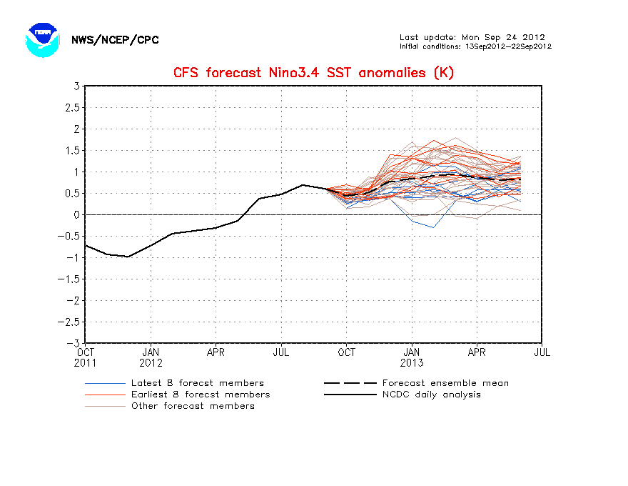
Dip,dip,dip,.CFS now goes Neutral by May and to La Nina by June.Lets see what the other ENSO models have later in the month.
http://www.cpc.ncep.noaa.gov/products/a ... cast.shtml
http://www.cpc.ncep.noaa.gov/products/a ... cast.shtml
0 likes
Visit the Caribbean-Central America Weather Thread where you can find at first post web cams,radars
and observations from Caribbean basin members Click Here
and observations from Caribbean basin members Click Here
That set of ensembles isn't quite as cold as the last months or worth or so. I do think we are about to see quite a quick drop towards neutral this morning, though quite how far down and how quick remains to be seen.
0 likes
Personal Forecast Disclaimer:
The posts in this forum are NOT official forecast and should not be used as such. They are just the opinion of the poster and may or may not be backed by sound meteorological data. They are NOT endorsed by any professional institution or storm2k.org. For official information, please refer to the NHC and NWS products
The posts in this forum are NOT official forecast and should not be used as such. They are just the opinion of the poster and may or may not be backed by sound meteorological data. They are NOT endorsed by any professional institution or storm2k.org. For official information, please refer to the NHC and NWS products
I think El Nino is pretty much stuffed, at least for the summer, esp given the Atmosphere is flipping back to being uncondusive towards El nino.
0 likes
Personal Forecast Disclaimer:
The posts in this forum are NOT official forecast and should not be used as such. They are just the opinion of the poster and may or may not be backed by sound meteorological data. They are NOT endorsed by any professional institution or storm2k.org. For official information, please refer to the NHC and NWS products
The posts in this forum are NOT official forecast and should not be used as such. They are just the opinion of the poster and may or may not be backed by sound meteorological data. They are NOT endorsed by any professional institution or storm2k.org. For official information, please refer to the NHC and NWS products
-
cycloneye
- Admin
- Posts: 149155
- Age: 69
- Joined: Thu Oct 10, 2002 10:54 am
- Location: San Juan, Puerto Rico
Re: ENSO Updates=CFS (NCEP) model forecasts Neutral by May
CFS is not alone as the Australian model POAMA in todays update does the same as CFS.
http://www.bom.gov.au/climate/coupled_model/poama.shtml

http://www.bom.gov.au/climate/coupled_model/poama.shtml
0 likes
Visit the Caribbean-Central America Weather Thread where you can find at first post web cams,radars
and observations from Caribbean basin members Click Here
and observations from Caribbean basin members Click Here
-
GeneratorPower

- S2K Supporter

- Posts: 1648
- Age: 46
- Joined: Sun Dec 18, 2005 11:48 pm
- Location: Huntsville, AL
Re:
Derek Ortt wrote:I may need to do an el nino dance soon, lol
You just love taking the lollipop away from the kiddos, don't cha?
0 likes
-
cycloneye
- Admin
- Posts: 149155
- Age: 69
- Joined: Thu Oct 10, 2002 10:54 am
- Location: San Juan, Puerto Rico
Re: ENSO Updates=CFS,POAMA models forecast Neutral by May
CFS monthly graphics show the rapid change from El Nino to Neutral by May and goes to La Nina by late summer.
http://www.cpc.ncep.noaa.gov/products/a ... cast.shtml
http://www.cpc.ncep.noaa.gov/products/a ... cast.shtml
0 likes
Visit the Caribbean-Central America Weather Thread where you can find at first post web cams,radars
and observations from Caribbean basin members Click Here
and observations from Caribbean basin members Click Here
-
Blown Away

- S2K Supporter
- Posts: 10253
- Joined: Wed May 26, 2004 6:17 am
Re: ENSO Updates=CFS,POAMA models forecast Neutral by May
Looking at the list there has been many significant storms in the hurricane season following the El Nino!
http://ggweather.com/enso/years.htm
http://ggweather.com/enso/years.htm
0 likes
Hurricane Eye Experience: David 79, Irene 99, Frances 04, Jeanne 04, Wilma 05… Hurricane Brush Experience: Andrew 92, Erin 95, Floyd 99, Matthew 16, Irma 17, Ian 22, Nicole 22…
-
WeatherEmperor
- S2K Supporter
- Posts: 4806
- Age: 42
- Joined: Thu Sep 04, 2003 2:54 pm
- Location: South Florida
Re: ENSO Updates=CFS,POAMA models forecast Neutral by May
Luis,
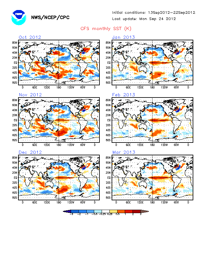
If you also look at the forecast SST for the Atlantic side on the graphic you posted above, you can see that the Atlantic SST cool off a bit as well especially towards August and September. They still look above normal, but it looks like the anomalies cool a lot compared to what they are now
If you also look at the forecast SST for the Atlantic side on the graphic you posted above, you can see that the Atlantic SST cool off a bit as well especially towards August and September. They still look above normal, but it looks like the anomalies cool a lot compared to what they are now
0 likes
Re: ENSO Updates=CFS,POAMA models forecast Neutral by May
Scary how the western carribean...which has the highest TCHP (tropical cyclone heat potential) in the entire Atlantic basin is forecast to have well above normal sst......that could be like steroids for a system late season...
cycloneye wrote:CFS monthly graphics show the rapid change from El Nino to Neutral by May and goes to La Nina by late summer.
http://www.cpc.ncep.noaa.gov/products/a ... cast.shtml
0 likes
Re: ENSO Updates=CFS,POAMA models forecast Neutral by May
WeatherEmperor wrote:Luis,
If you also look at the forecast SST for the Atlantic side on the graphic you posted above, you can see that the Atlantic SST cool off a bit as well especially towards August and September. They still look above normal, but it looks like the anomalies cool a lot compared to what they are now
Yeah but considering we are at record levels right now, of course they are gonna cool!
Put it this way, they are still WELL above average for the region, the MDR would probably be around 0.5-0.7C for the summer, which is very above average, plus the highest anomalies shift westwards, just like they usually do in severe seasons....
Anyway looking likely cool neutral/la nina will occur now looking at things.
0 likes
Personal Forecast Disclaimer:
The posts in this forum are NOT official forecast and should not be used as such. They are just the opinion of the poster and may or may not be backed by sound meteorological data. They are NOT endorsed by any professional institution or storm2k.org. For official information, please refer to the NHC and NWS products
The posts in this forum are NOT official forecast and should not be used as such. They are just the opinion of the poster and may or may not be backed by sound meteorological data. They are NOT endorsed by any professional institution or storm2k.org. For official information, please refer to the NHC and NWS products
-
WeatherEmperor
- S2K Supporter
- Posts: 4806
- Age: 42
- Joined: Thu Sep 04, 2003 2:54 pm
- Location: South Florida
Re: ENSO Updates=CFS,POAMA models forecast Neutral by May
KWT wrote:WeatherEmperor wrote:Luis,
If you also look at the forecast SST for the Atlantic side on the graphic you posted above, you can see that the Atlantic SST cool off a bit as well especially towards August and September. They still look above normal, but it looks like the anomalies cool a lot compared to what they are now
Yeah but considering we are at record levels right now, of course they are gonna cool!
Put it this way, they are still WELL above average for the region, the MDR would probably be around 0.5-0.7C for the summer, which is very above average, plus the highest anomalies shift westwards, just like they usually do in severe seasons....
Anyway looking likely cool neutral/la nina will occur now looking at things.
Yeah I guess you are right. I looked at the maps again and I see your point. Looks like an above average season is likely based on the SST anomalies, weakening El Nino and lower sea level pressure forecasts.
0 likes
-
cycloneye
- Admin
- Posts: 149155
- Age: 69
- Joined: Thu Oct 10, 2002 10:54 am
- Location: San Juan, Puerto Rico
Re: ENSO Updates=CFS,POAMA models forecast Neutral by May
WeatherEmperor,what KWT said it very accurate about the sst anomalies in the Atlantic.Even if they go down by the peak of the season,they will be above average and that alone spells trouble for the Caribbean.The other factors like ENSO being Neutral to La Nina,lower pressures in the Caribbean and MDR will be favorable for plenty of tropical cyclone activity in the Atlantic basin.
0 likes
Visit the Caribbean-Central America Weather Thread where you can find at first post web cams,radars
and observations from Caribbean basin members Click Here
and observations from Caribbean basin members Click Here
-
cycloneye
- Admin
- Posts: 149155
- Age: 69
- Joined: Thu Oct 10, 2002 10:54 am
- Location: San Juan, Puerto Rico
Re: ENSO Updates=CFS,POAMA models forecast Neutral by May
CFS Model
No changes from the past week from the CFS (NCEP) model having Neutral ENSO as early as May and slipping to La Nina by late Summer.
http://www.cpc.ncep.noaa.gov/products/a ... cast.shtml
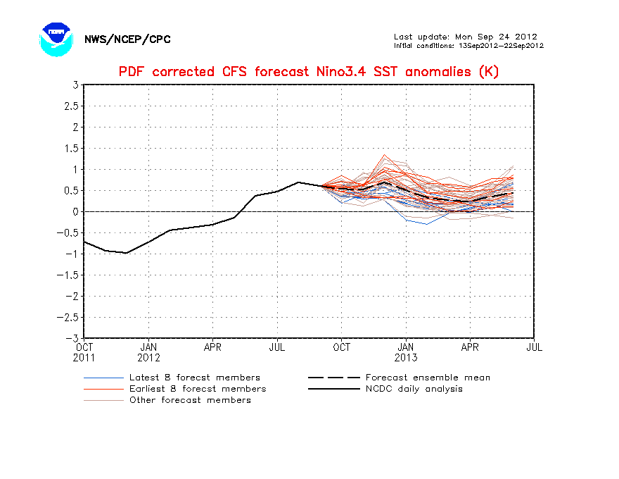
CFS Model with all the ensembles

No changes from the past week from the CFS (NCEP) model having Neutral ENSO as early as May and slipping to La Nina by late Summer.
http://www.cpc.ncep.noaa.gov/products/a ... cast.shtml
CFS Model with all the ensembles
0 likes
Visit the Caribbean-Central America Weather Thread where you can find at first post web cams,radars
and observations from Caribbean basin members Click Here
and observations from Caribbean basin members Click Here
Yeah the CFS is still very keen to go borderline La Nina...I'm still not totally sure we will go that cold as the models struggle in the southern hemisphere Autumn with the ENSO.
0 likes
Personal Forecast Disclaimer:
The posts in this forum are NOT official forecast and should not be used as such. They are just the opinion of the poster and may or may not be backed by sound meteorological data. They are NOT endorsed by any professional institution or storm2k.org. For official information, please refer to the NHC and NWS products
The posts in this forum are NOT official forecast and should not be used as such. They are just the opinion of the poster and may or may not be backed by sound meteorological data. They are NOT endorsed by any professional institution or storm2k.org. For official information, please refer to the NHC and NWS products
-
cycloneye
- Admin
- Posts: 149155
- Age: 69
- Joined: Thu Oct 10, 2002 10:54 am
- Location: San Juan, Puerto Rico
Re: ENSO Updates=Climate Prediction Center 4/5/10 update
I know the update is delayed here as it comes out in the morning hours but I had a medical appointment.Here is the Climate Prediction Center 4/5/10.El Nino 3.4 area continues to decrease although on a slow pace now down to +1.0C from +1.1C of last week.
Last Week Numbers
Niño 4= +1.0ºC
Niño 3.4= +1.1ºC
Niño 3= +0.7ºC
Niño1+2= +0.1ºC
This Week Numbers
Niño 4= +0.9ºC
Niño 3.4= +1.0ºC
Niño 3= +0.9ºC
Niño1+2= +0.1ºC
http://www.cpc.ncep.noaa.gov/products/a ... ts-web.pdf

Last Week Numbers
Niño 4= +1.0ºC
Niño 3.4= +1.1ºC
Niño 3= +0.7ºC
Niño1+2= +0.1ºC
This Week Numbers
Niño 4= +0.9ºC
Niño 3.4= +1.0ºC
Niño 3= +0.9ºC
Niño1+2= +0.1ºC
http://www.cpc.ncep.noaa.gov/products/a ... ts-web.pdf
0 likes
Visit the Caribbean-Central America Weather Thread where you can find at first post web cams,radars
and observations from Caribbean basin members Click Here
and observations from Caribbean basin members Click Here
-
HouTXmetro

- Category 5

- Posts: 3949
- Joined: Sun Jun 13, 2004 6:00 pm
- Location: District of Columbia, USA
-
cycloneye
- Admin
- Posts: 149155
- Age: 69
- Joined: Thu Oct 10, 2002 10:54 am
- Location: San Juan, Puerto Rico
Re:
HouTXmetro wrote:were we in Neutral or La Nina in 2005?
Neutral.

0 likes
Visit the Caribbean-Central America Weather Thread where you can find at first post web cams,radars
and observations from Caribbean basin members Click Here
and observations from Caribbean basin members Click Here
Who is online
Users browsing this forum: No registered users and 79 guests