ATL: IKE Discussion

Moderator: S2k Moderators

Message
Author
Matt-hurricanewatcher

Re:

#1241 Postby Matt-hurricanewatcher » Thu Sep 04, 2008 2:21 am

Meso wrote:Image

Ecplise over on the floater


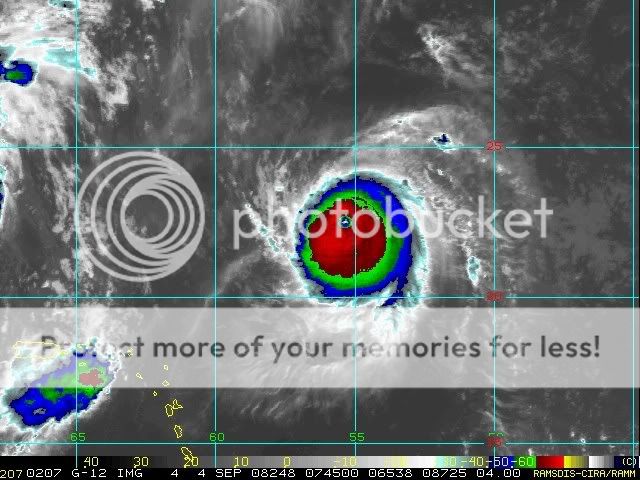
Cat5 red ring around the eye. All it needs now is for the eye to clear out some.
0 likes   

Scorpion

#1242 Postby Scorpion » Thu Sep 04, 2008 2:24 am

If this were to become a Cat 5 shortly or it already is one would it not compare to Wilma?
0 likes   

User avatar
RattleMan
Category 5
Category 5
Posts: 1218
Joined: Wed Aug 24, 2005 7:14 pm
Location: Phoenix, AZ

Re: ATL IKE: Category 4 - Discussion

#1243 Postby RattleMan » Thu Sep 04, 2008 2:27 am

06z best track:

AL, 09, 2008090406, , BEST, 0, 224N, 550W, 125, 935, HU, 34, NEQ, 120, 100, 75, 120, 1008, 175, 15, 0, 0, L, 0, , 0, 0, IKE, D,
AL, 09, 2008090406, , BEST, 0, 224N, 550W, 125, 935, HU, 50, NEQ, 75, 50, 40, 60, 1008, 175, 15, 0, 0, L, 0, , 0, 0, IKE, D,
AL, 09, 2008090406, , BEST, 0, 224N, 550W, 125, 935, HU, 64, NEQ, 30, 25, 20, 25, 1008, 175, 15, 0, 0, L, 0, , 0, 0, IKE, D,
0 likes   

Matt-hurricanewatcher

Re: ATL IKE: Category 4 - Discussion

#1244 Postby Matt-hurricanewatcher » Thu Sep 04, 2008 2:29 am

RattleMan wrote:06z best track:

AL, 09, 2008090406, , BEST, 0, 224N, 550W, 125, 935, HU, 34, NEQ, 120, 100, 75, 120, 1008, 175, 15, 0, 0, L, 0, , 0, 0, IKE, D,
AL, 09, 2008090406, , BEST, 0, 224N, 550W, 125, 935, HU, 50, NEQ, 75, 50, 40, 60, 1008, 175, 15, 0, 0, L, 0, , 0, 0, IKE, D,
AL, 09, 2008090406, , BEST, 0, 224N, 550W, 125, 935, HU, 64, NEQ, 30, 25, 20, 25, 1008, 175, 15, 0, 0, L, 0, , 0, 0, IKE, D,


125 knots/935 millibars

Based on pressure this is the most intense system of 2008.
0 likes   

Scorpion

#1245 Postby Scorpion » Thu Sep 04, 2008 2:32 am

I think it's pretty incredible how we waited and waited for invests to form into TD's all year and yet this system is just perfect, going through each stage with very little resistance.
0 likes   

User avatar
RattleMan
Category 5
Category 5
Posts: 1218
Joined: Wed Aug 24, 2005 7:14 pm
Location: Phoenix, AZ

Re: ATL IKE: Category 4 - Discussion

#1246 Postby RattleMan » Thu Sep 04, 2008 2:34 am

Matt-hurricanewatcher wrote:125 knots/935 millibars

Based on pressure this is the most intense system of 2008.


Not quite; Hondo in the SWIO got 906 from the RSMC.

ftp://ftp.met.fsu.edu/pub/weather/tropi ... 20718-FMEE
0 likes   

Matt-hurricanewatcher

Re: ATL IKE: Category 4 - Discussion

#1247 Postby Matt-hurricanewatcher » Thu Sep 04, 2008 2:38 am

RattleMan wrote:
Matt-hurricanewatcher wrote:125 knots/935 millibars

Based on pressure this is the most intense system of 2008.


Not quite; Hondo in the SWIO got 906 from the RSMC.

ftp://ftp.met.fsu.edu/pub/weather/tropi ... 20718-FMEE


Should of said for the Atlantic.
0 likes   

Nexus
Tropical Storm
Tropical Storm
Posts: 137
Joined: Sat Sep 11, 2004 12:13 am

#1248 Postby Nexus » Thu Sep 04, 2008 2:59 am

Image
0 likes   

Nexus
Tropical Storm
Tropical Storm
Posts: 137
Joined: Sat Sep 11, 2004 12:13 am

#1249 Postby Nexus » Thu Sep 04, 2008 3:06 am

Looks incredibly self contained, and tiny compared to the Hanna mess. Almost completely surrounded by dry air which apparently cannot find it's way in, and two modest outflow connections. Simply amazing:

Image
0 likes   

Nexus
Tropical Storm
Tropical Storm
Posts: 137
Joined: Sat Sep 11, 2004 12:13 am

#1250 Postby Nexus » Thu Sep 04, 2008 3:12 am

You can see the slot starting to open up SE of Hanna for Ike, in this loop:

http://rammb.cira.colostate.edu/ramsdis ... 4km_visir2
0 likes   

User avatar
Meso
Category 5
Category 5
Posts: 1609
Age: 38
Joined: Mon Aug 09, 2004 12:14 pm
Location: South Africa
Contact:

#1251 Postby Meso » Thu Sep 04, 2008 3:19 am

Interesting, the eye seems to be 'closing up', either just some fluctuation in size. Or Ike is getting ready for his first EWRC.
0 likes   

Hockey007
Tropical Depression
Tropical Depression
Posts: 51
Joined: Mon Aug 20, 2007 11:02 pm

Re: ATL IKE: Category 4 - Discussion

#1252 Postby Hockey007 » Thu Sep 04, 2008 3:20 am

Is it just me or the eyewall is contracting quite a bit? Haha, I guess it was answered in the last post... I didn't see it until after I posted.
Image
0 likes   

User avatar
Meso
Category 5
Category 5
Posts: 1609
Age: 38
Joined: Mon Aug 09, 2004 12:14 pm
Location: South Africa
Contact:

#1253 Postby Meso » Thu Sep 04, 2008 3:21 am

Nope it's not just you :) That also could be another option, Ike could be getting an even smaller eye? If that's even possible
0 likes   

Hockey007
Tropical Depression
Tropical Depression
Posts: 51
Joined: Mon Aug 20, 2007 11:02 pm

Re: ATL IKE: Category 4 - Discussion

#1254 Postby Hockey007 » Thu Sep 04, 2008 3:23 am

Wilma had a 2nm eye if I remember correctly during her rapid intensification cycle which wouldn't surprise me if Ike had a small eye as well... if Ike feels like intensifying more... Looking at the the picture again, it's probably an EWRC or something.
Last edited by Hockey007 on Thu Sep 04, 2008 3:27 am, edited 1 time in total.
0 likes   

Nexus
Tropical Storm
Tropical Storm
Posts: 137
Joined: Sat Sep 11, 2004 12:13 am

Re:

#1255 Postby Nexus » Thu Sep 04, 2008 3:27 am

Meso wrote:Nope it's not just you :) That also could be another option, Ike could be getting an even smaller eye? If that's even possible


Hopefully it's not behaving like a collapsing star before a supernova :)

Seriously though, Ike looks about as mean as it gets presently.
0 likes   

User avatar
RattleMan
Category 5
Category 5
Posts: 1218
Joined: Wed Aug 24, 2005 7:14 pm
Location: Phoenix, AZ

Re: ATL IKE: Category 4 - Discussion

#1256 Postby RattleMan » Thu Sep 04, 2008 3:40 am

000
WTNT24 KNHC 040836
TCMAT4
HURRICANE IKE FORECAST/ADVISORY NUMBER 13
NWS TPC/NATIONAL HURRICANE CENTER MIAMI FL AL092008
0900 UTC THU SEP 04 2008
...
ESTIMATED MINIMUM CENTRAL PRESSURE 935 MB
MAX SUSTAINED WINDS 125 KT WITH GUSTS TO 155 KT.
0 likes   

Hockey007
Tropical Depression
Tropical Depression
Posts: 51
Joined: Mon Aug 20, 2007 11:02 pm

Re: ATL IKE: Category 4 - Discussion

#1257 Postby Hockey007 » Thu Sep 04, 2008 3:40 am

Wow... less than 35 miles between 125kt and 65 kt
Edit: whoops late by a few seconds.
0 likes   

User avatar
boca
Category 5
Category 5
Posts: 6367
Age: 60
Joined: Mon Dec 15, 2003 8:49 am
Location: Boca Raton,FL

Re: ATL IKE: Category 4 - Discussion

#1258 Postby boca » Thu Sep 04, 2008 4:06 am

Wxman57 was right the models keep on shifting right. S FL might be in the clear with Ike after all if it turns NNW in the Bahamas.Other than Fay we are dodging Hanna, now maybe Ike.
0 likes   

User avatar
Meso
Category 5
Category 5
Posts: 1609
Age: 38
Joined: Mon Aug 09, 2004 12:14 pm
Location: South Africa
Contact:

#1259 Postby Meso » Thu Sep 04, 2008 4:12 am

I don't know though, It may be a bit early to tell. Agreed it's looking less likely than yesterday. But there are still quite a few models in that area. Only 2 or so take the storm to a guarenteed "Out to sea", While most of the models show the NNW turn as it approached Florida. A landfall somewhere along the east coast looks quite possible, though Florida does look safer than 24 hours ago
0 likes   

User avatar
wxman57
Moderator-Pro Met
Moderator-Pro Met
Posts: 22980
Age: 67
Joined: Sat Jun 21, 2003 8:06 pm
Location: Houston, TX (southwest)

Re: ATL IKE: Category 4 - Discussion

#1260 Postby wxman57 » Thu Sep 04, 2008 4:18 am

boca wrote:Wxman57 was right the models keep on shifting right. S FL might be in the clear with Ike after all if it turns NNW in the Bahamas.Other than Fay we are dodging Hanna, now maybe Ike.


Just woke up. Here are the 6Z models. Shift east continues:

Image
0 likes   


Return to “2008”

Who is online

Users browsing this forum: No registered users and 6 guests