2019 Tropics: Global Model Runs Discussion (Out to day 16)

This is the general tropical discussion area. Anyone can take their shot at predicting a storms path.

Moderator: S2k Moderators

Forum rules

The posts in this forum are NOT official forecasts and should not be used as such. They are just the opinion of the poster and may or may not be backed by sound meteorological data. They are NOT endorsed by any professional institution or STORM2K. For official information, please refer to products from the National Hurricane Center and National Weather Service.

Help Support Storm2K
Message
Author
User avatar
SFLcane
S2K Supporter
S2K Supporter
Posts: 10163
Age: 47
Joined: Sat Jun 05, 2010 1:44 pm
Location: Lake Worth Florida

Re: 2019 Tropics: Global Model Runs Discussion (Out to day 16)

#1241 Postby SFLcane » Mon Oct 07, 2019 6:19 am

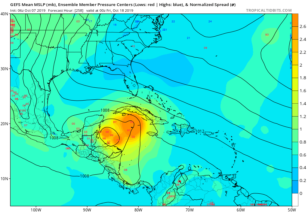
USTropics wrote:Some ensemble support from the 00z ECMWF now evident in the Caribbean. Also backing off on the far EATL hurricane:

https://i.imgur.com/09tAfbM.png

A few tracks take this across the Yucatan:
https://i.imgur.com/VfJXhiC.png


Also worth noting that almost all the members that develop something move it west into the Yucatan. Deterministic Euro also hasn't had a single run develop this. That stuff over FL is the broad low currently over the NW Caribbean.
0 likes   

User avatar
gatorcane
S2K Supporter
S2K Supporter
Posts: 23691
Age: 47
Joined: Sun Mar 13, 2005 3:54 pm
Location: Boca Raton, FL

Re: 2019 Tropics: Global Model Runs Discussion (Out to day 16)

#1242 Postby gatorcane » Mon Oct 07, 2019 6:28 am

How does a hurricane that strong that the GFS is showing with a trough over the Gulf and Florida not turn north? Climo strongly suggests it at least where the GFS is showing genesis.

Note the GEFS seems more in line with climo and very active I must say:

Image
0 likes   

User avatar
SFLcane
S2K Supporter
S2K Supporter
Posts: 10163
Age: 47
Joined: Sat Jun 05, 2010 1:44 pm
Location: Lake Worth Florida

Re: 2019 Tropics: Global Model Runs Discussion (Out to day 16)

#1243 Postby SFLcane » Mon Oct 07, 2019 6:32 am

gatorcane wrote:How does a hurricane that strong that the GFS is showing with a trough over the Gulf and Florida not turn north? Climo strongly suggests it at least where the GFS is showing genesis.


Because that trough is to the northeast of the storm so it gets caught under the Western ridge. EPS what ever little support there is also takes it westward.
0 likes   

User avatar
Hypercane_Kyle
Category 5
Category 5
Posts: 3352
Joined: Sat Mar 07, 2015 7:58 pm
Location: Cape Canaveral, FL

Re: 2019 Tropics: Global Model Runs Discussion (Out to day 16)

#1244 Postby Hypercane_Kyle » Mon Oct 07, 2019 6:34 am

00z CMC and 00z UKMET now support development too.
0 likes   
My posts are my own personal opinion, defer to the National Hurricane Center (NHC) and other NOAA products for decision making during hurricane season.

User avatar
SFLcane
S2K Supporter
S2K Supporter
Posts: 10163
Age: 47
Joined: Sat Jun 05, 2010 1:44 pm
Location: Lake Worth Florida

Re: 2019 Tropics: Global Model Runs Discussion (Out to day 16)

#1245 Postby SFLcane » Mon Oct 07, 2019 6:37 am

Though quite active Looks like almost all 06z GEFS go into the Yucatan.
0 likes   

Aric Dunn
Category 5
Category 5
Posts: 21238
Age: 42
Joined: Sun Sep 19, 2004 9:58 pm
Location: Ready for the Chase.
Contact:

Re: 2019 Tropics: Global Model Runs Discussion (Out to day 16)

#1246 Postby Aric Dunn » Mon Oct 07, 2019 6:38 am

Models have been showing various vorts along the trough danggling from south gulf out to Bermuda. So besides the obvious sub tropical development that started yesterday ene of bahamas. Could see a quick spin up td along florida east coast. Area to watch is south of miami and north of cuba.
0 likes   
Note: If I make a post that is brief. Please refer back to previous posts for the analysis or reasoning. I do not re-write/qoute what my initial post said each time.
If there is nothing before... then just ask :)

Space & Atmospheric Physicist, Embry-Riddle Aeronautical University,
I believe the sky is falling...

User avatar
Ivanhater
Storm2k Moderator
Storm2k Moderator
Posts: 11161
Age: 38
Joined: Fri Jul 01, 2005 8:25 am
Location: Pensacola

Re: 2019 Tropics: Global Model Runs Discussion (Out to day 16)

#1247 Postby Ivanhater » Mon Oct 07, 2019 6:38 am

Cmc similar to Gfs over Yucatan into southern gulf
0 likes   
Michael

User avatar
SFLcane
S2K Supporter
S2K Supporter
Posts: 10163
Age: 47
Joined: Sat Jun 05, 2010 1:44 pm
Location: Lake Worth Florida

Re: 2019 Tropics: Global Model Runs Discussion (Out to day 16)

#1248 Postby SFLcane » Mon Oct 07, 2019 6:42 am

Yeah I mean GEFS/GFS are very much all in on this thing. Usually once it's inside 7 days like this it's pretty reliable But by then the Euro usually has something. So I still think it could be (probably is?) convective bias to some extent.
Last edited by SFLcane on Mon Oct 07, 2019 6:43 am, edited 1 time in total.
0 likes   

User avatar
SFLcane
S2K Supporter
S2K Supporter
Posts: 10163
Age: 47
Joined: Sat Jun 05, 2010 1:44 pm
Location: Lake Worth Florida

Re: 2019 Tropics: Global Model Runs Discussion (Out to day 16)

#1249 Postby SFLcane » Mon Oct 07, 2019 6:43 am

Hypercane_Kyle wrote:00z CMC and 00z UKMET now support development too.


UKMET and deterministic Euro show nothing.
0 likes   

User avatar
Hypercane_Kyle
Category 5
Category 5
Posts: 3352
Joined: Sat Mar 07, 2015 7:58 pm
Location: Cape Canaveral, FL

Re: 2019 Tropics: Global Model Runs Discussion (Out to day 16)

#1250 Postby Hypercane_Kyle » Mon Oct 07, 2019 6:51 am

SFLcane wrote:
Hypercane_Kyle wrote:00z CMC and 00z UKMET now support development too.


UKMET and deterministic Euro show nothing.


00z UKMET has a weak low in the SW Caribbean by D7.

Image
0 likes   
My posts are my own personal opinion, defer to the National Hurricane Center (NHC) and other NOAA products for decision making during hurricane season.

User avatar
toad strangler
S2K Supporter
S2K Supporter
Posts: 4543
Joined: Sun Jul 28, 2013 3:09 pm
Location: Earth
Contact:

Re: 2019 Tropics: Global Model Runs Discussion (Out to day 16)

#1251 Postby toad strangler » Mon Oct 07, 2019 6:52 am

What happened to the catch phrase "You want to be in the bullseye this far out because you know it's not coming" :spam:
I don't buy any run by run track. All that matters for now is the growing model consensus for a storm. And yes, right now the Euro is becoming the outlier.
Very interseting.
Last edited by toad strangler on Mon Oct 07, 2019 6:53 am, edited 1 time in total.
4 likes   

User avatar
Blown Away
S2K Supporter
S2K Supporter
Posts: 10145
Joined: Wed May 26, 2004 6:17 am

Re: 2019 Tropics: Global Model Runs Discussion (Out to day 16)

#1252 Postby Blown Away » Mon Oct 07, 2019 6:52 am

Image
06z GFS... Low appears @144 hours and finishes into NGOM GOM... Seems if this model low avoids Yucatan it may be a major hurricane...
0 likes   
Hurricane Eye Experience: David 79, Irene 99, Frances 04, Jeanne 04, Wilma 05... EYE COMING MY WAY IN 2024…
Hurricane Brush Experience: Andrew 92, Erin 95, Floyd 99, Matthew 16, Irma 17, Ian 22, Nicole 22…

User avatar
SFLcane
S2K Supporter
S2K Supporter
Posts: 10163
Age: 47
Joined: Sat Jun 05, 2010 1:44 pm
Location: Lake Worth Florida

Re: 2019 Tropics: Global Model Runs Discussion (Out to day 16)

#1253 Postby SFLcane » Mon Oct 07, 2019 7:00 am

1 likes   

User avatar
HurricaneBelle
S2K Supporter
S2K Supporter
Posts: 1179
Joined: Sun Aug 27, 2006 6:12 pm
Location: Clearwater, FL

Re: 2019 Tropics: Global Model Runs Discussion (Out to day 16)

#1254 Postby HurricaneBelle » Mon Oct 07, 2019 7:22 am

Blown Away wrote:06z GFS... Low appears @144 hours and finishes into NGOM GOM... Seems if this model low avoids Yucatan it may be a major hurricane...


This track would be the spitting image of Isidore 2002
1 likes   

User avatar
Emmett_Brown
Category 5
Category 5
Posts: 1432
Joined: Wed Aug 24, 2005 9:10 pm
Location: Sarasota FL

Re: 2019 Tropics: Global Model Runs Discussion (Out to day 16)

#1255 Postby Emmett_Brown » Mon Oct 07, 2019 7:25 am

Reminds me of the 1998 pattern that sent Mitch W into central America. Hopefully nothing as strong as Mitch will form though.
1 likes   

User avatar
NDG
S2K Supporter
S2K Supporter
Posts: 15446
Joined: Sun Jul 09, 2006 10:14 pm
Location: Orlando, FL

Re: 2019 Tropics: Global Model Runs Discussion (Out to day 16)

#1256 Postby NDG » Mon Oct 07, 2019 7:26 am

Past 5-6 days mid level sypnotic set up are really hard to know for sure. We are talking about possible formation near the 6-7 days range, even if there is a narrow east to west mid level ridging to the north of the south central Caribbean that would mean a system that would move westward towards C.A. or western Caribbean, so any little weakening of that mid level ridge like it usually happens this time of the year it would mean a poleward track of whatever it is down there. I would not write the Euro's forecast past 5-6 days on stone.

Image
2 likes   

USTropics
Professional-Met
Professional-Met
Posts: 2651
Joined: Sun Aug 12, 2007 3:45 am
Location: Florida State University

Re: 2019 Tropics: Global Model Runs Discussion (Out to day 16)

#1257 Postby USTropics » Mon Oct 07, 2019 7:40 am

The difference between the GFS ensembles and the ECMWF ensembles with the how far south the trough over the EC digs down is why most of the ECMWF ensemble members bury this into Central America:
Image

A lot will change with the upper-level pattern in future runs, as you can see with the trough position in the past 4 GFS run trend:
Image
2 likes   

User avatar
chaser1
S2K Supporter
S2K Supporter
Posts: 5464
Age: 64
Joined: Sat Oct 15, 2005 5:59 pm
Location: Longwood, Fl

Re: 2019 Tropics: Global Model Runs Discussion (Out to day 16)

#1258 Postby chaser1 » Mon Oct 07, 2019 7:48 am

Emmett_Brown wrote:Reminds me of the 1998 pattern that sent Mitch W into central America. Hopefully nothing as strong as Mitch will form though.


Was thinking exactly the same thing here. Coincidentally, we'd potentially be at the "M" storm again too (barring any subtropical development over the N. Atlantic.... but then again, it's not as if NHC is at all quick on naming those this year :wink: )
2 likes   
Andy D

(For official information, please refer to the NHC and NWS products.)

User avatar
chaser1
S2K Supporter
S2K Supporter
Posts: 5464
Age: 64
Joined: Sat Oct 15, 2005 5:59 pm
Location: Longwood, Fl

Re: 2019 Tropics: Global Model Runs Discussion (Out to day 16)

#1259 Postby chaser1 » Mon Oct 07, 2019 7:54 am

NDG wrote:Past 5-6 days mid level sypnotic set up are really hard to know for sure. We are talking about possible formation near the 6-7 days range, even if there is a narrow east to west mid level ridging to the north of the south central Caribbean that would mean a system that would move westward towards C.A. or western Caribbean, so any little weakening of that mid level ridge like it usually happens this time of the year it would mean a poleward track of whatever it is down there. I would not write the Euro's forecast past 5-6 days on stone.

https://i.imgur.com/xj7ydwF.gif


I agree and tend to think that climo and the synoptic set up would lean toward any organizing system to gain latitude toward the N.W. Caribbean. My only guess on the EURO's resistance against genesis is that the process would be so slow to develop, that any "nearer term" gyre might simply drift primarily westward especially at a lower latitude right now. I think the primary difference between the UK/EURO camp and the GFS and GEM would be whether the overall upper level conditions are or are not particularly conducive for development to even occur during the approaching 5-7 day period.
1 likes   
Andy D

(For official information, please refer to the NHC and NWS products.)

User avatar
blp
Category 5
Category 5
Posts: 2840
Age: 46
Joined: Thu Sep 09, 2004 7:51 pm
Location: Miami, FL
Contact:

Re: 2019 Tropics: Global Model Runs Discussion (Out to day 16)

#1260 Postby blp » Mon Oct 07, 2019 7:56 am

NAVGEM with a big ramp up on the 06z. So its the GFS, Icon, Navgem, CMC, Ukmet on board. Only a matter of time now for the Euro to come in.

Image
2 likes   
The following post is NOT an official forecast and should not be used as such. It is just the opinion of the poster and may or may not be backed by sound meteorological data. It is NOT endorsed by any professional institution including storm2k.org For Official Information please refer to the NHC and NWS products.


Return to “Talkin' Tropics”

Who is online

Users browsing this forum: jgh and 28 guests