ATL: CHANTAL - Post-Tropical

Moderator: S2k Moderators

Message
Author
Syx6sic
Tropical Depression
Tropical Depression
Posts: 84
Age: 41
Joined: Wed Jun 05, 2013 12:11 pm
Location: Virginia beach VA

Re: Re:

#1261 Postby Syx6sic » Mon Jul 08, 2013 6:49 pm

Aric Dunn wrote:
Syx6sic wrote:Is it just me or does it look like recon going back home?


they should drop to do one more pass


That's what I am hoping they do I wanna find the true powers on this one seems to be trying to hide them
0 likes   
Personal Forecast Disclaimer:
The posts in this forum are NOT official forecast and should not be used as such. They are just the opinion of the poster and may or may not be backed by sound meteorological data. They are NOT endorsed by any professional institution or storm2k.org. For official information, please refer to the NHC and NWS products.

User avatar
artist
Category 5
Category 5
Posts: 9792
Joined: Mon Jun 06, 2005 3:26 pm
Location: West Palm

#1262 Postby artist » Mon Jul 08, 2013 6:52 pm

URNT15 KNHC 082346
AF302 0103A CHANTAL HDOB 33 20130708
233800 1250N 05532W 9661 00414 0128 +230 +201 060041 042 037 001 03
233830 1250N 05534W 9671 00404 0128 +230 +210 055037 042 035 000 00
233900 1250N 05536W 9664 00410 0127 +230 +208 057037 038 032 001 00
233930 1250N 05538W 9669 00407 0128 +230 +207 058036 038 033 001 00
234000 1250N 05539W 9664 00412 0130 +230 +212 056034 035 033 000 00
234030 1250N 05541W 9668 00409 0130 +230 +209 057035 036 032 000 00
234100 1250N 05543W 9663 00414 0130 +231 +208 057034 036 031 001 00
234130 1250N 05545W 9665 00412 0130 +230 +208 058032 033 031 001 00
234200 1250N 05547W 9665 00413 0130 +232 +208 058033 034 031 000 00
234230 1250N 05549W 9664 00414 0130 +233 +209 060033 035 031 001 00
234300 1250N 05550W 9664 00415 0131 +231 +212 058033 034 032 000 00
234330 1250N 05552W 9662 00416 0132 +230 +215 056034 034 030 001 00
234400 1250N 05554W 9667 00412 0132 +230 +215 051031 034 029 000 00
234430 1250N 05556W 9668 00413 0133 +230 +215 053030 032 029 000 00
234500 1250N 05558W 9666 00413 0133 +230 +217 054030 031 028 001 00
234530 1250N 05559W 9666 00414 0134 +230 +215 055031 032 029 000 00
234600 1250N 05601W 9665 00417 0135 +230 +213 055031 032 030 000 00
234630 1250N 05603W 9666 00416 0135 +230 +216 050029 030 029 000 00
234700 1250N 05605W 9662 00420 0135 +230 +213 050028 030 027 000 00
234730 1250N 05607W 9671 00411 0135 +230 +214 049028 029 025 001 03
$$
0 likes   

Aric Dunn
Category 5
Category 5
Posts: 21238
Age: 42
Joined: Sun Sep 19, 2004 9:58 pm
Location: Ready for the Chase.
Contact:

Re: Re:

#1263 Postby Aric Dunn » Mon Jul 08, 2013 6:52 pm

Evil Jeremy wrote:
Aric Dunn wrote:
Syx6sic wrote:Is it just me or does it look like recon going back home?


they should drop to do one more pass


Recon is scheduled to investigate until 8:30pm.


though they were a half hour late taking off.
0 likes   
Note: If I make a post that is brief. Please refer back to previous posts for the analysis or reasoning. I do not re-write/qoute what my initial post said each time.
If there is nothing before... then just ask :)

Space & Atmospheric Physicist, Embry-Riddle Aeronautical University,
I believe the sky is falling...

User avatar
Hurricane Alexis
Category 2
Category 2
Posts: 683
Age: 29
Joined: Thu Jun 14, 2012 7:59 pm
Location: Miami,Florida

Re: ATL: CHANTAL - Tropical Storm - Discussion

#1264 Postby Hurricane Alexis » Mon Jul 08, 2013 6:56 pm

Pressure up to 1010 mb and winds up to 50 mph.
0 likes   
Personal Forecast Disclaimer:
The posts in this forum are NOT official forecast and should not be used as such. They are just the opinion of the poster and may or may not be backed by sound meteorological data. They are NOT endorsed by any professional institution or storm2k.org. For official information, please refer to the NHC and NWS products.

Dean4Storms
S2K Supporter
S2K Supporter
Posts: 6358
Age: 62
Joined: Sun Aug 31, 2003 1:01 pm
Location: Miramar Bch. FL

#1265 Postby Dean4Storms » Mon Jul 08, 2013 6:56 pm

0 likes   

User avatar
cycloneye
Admin
Admin
Posts: 145456
Age: 68
Joined: Thu Oct 10, 2002 10:54 am
Location: San Juan, Puerto Rico

Re: ATL: CHANTAL - Advisories

#1266 Postby cycloneye » Mon Jul 08, 2013 6:56 pm

BULLETIN
TROPICAL STORM CHANTAL INTERMEDIATE ADVISORY NUMBER 4A
NWS NATIONAL HURRICANE CENTER MIAMI FL AL032013
800 PM AST MON JUL 08 2013

...RECONNAISSANCE AIRCRAFT FINDS CHANTAL A LITTLE STRONGER...


SUMMARY OF 800 PM AST...0000 UTC...INFORMATION
----------------------------------------------
LOCATION...11.8N 55.0W
ABOUT 320 MI...515 KM ESE OF BARBADOS
MAXIMUM SUSTAINED WINDS...50 MPH...85 KM/H
PRESENT MOVEMENT...WNW OR 285 DEGREES AT 26 MPH...43 KM/H
MINIMUM CENTRAL PRESSURE...1010 MB...29.82 INCHES


WATCHES AND WARNINGS
--------------------
CHANGES WITH THIS ADVISORY...

NONE.

SUMMARY OF WATCHES AND WARNINGS IN EFFECT...

A TROPICAL STORM WARNING IS IN EFFECT FOR...
* BARBADOS
* DOMINICA
* ST. LUCIA
* MARTINIQUE
* GUADELOUPE
* PUERTO RICO

A TROPICAL STORM WATCH IS IN EFFECT FOR...
* ST. VINCENT
* U.S. VIRGIN ISLANDS
* VIEQUES AND CULEBRA
* SOUTHERN COAST OF DOMINICAN REPUBLIC FROM CABO ENGANO TO THE
BORDER WITH HAITI

ADDITIONAL WATCHES AND WARNINGS COULD BE REQUIRED FOR A PORTION OF
THE NORTHERN LEEWARD ISLANDS LATER TONIGHT. INTERESTS IN THIS AREA
SHOULD MONITOR THE PROGRESS OF CHANTAL.

INTERESTS IN HAITI AND EASTERN CUBA SHOULD ALSO MONITOR THE PROGRESS
OF CHANTAL.

FOR STORM INFORMATION SPECIFIC TO YOUR AREA IN THE UNITED STATES...
INCLUDING POSSIBLE INLAND WATCHES AND WARNINGS...PLEASE MONITOR
PRODUCTS ISSUED BY YOUR LOCAL NATIONAL WEATHER SERVICE FORECAST
OFFICE. FOR STORM INFORMATION SPECIFIC TO YOUR AREA OUTSIDE THE
UNITED STATES...PLEASE MONITOR PRODUCTS ISSUED BY YOUR NATIONAL
METEOROLOGICAL SERVICE.


DISCUSSION AND 48-HOUR OUTLOOK
------------------------------
AT 800 PM AST...0000 UTC...THE CENTER OF TROPICAL STORM CHANTAL WAS
LOCATED NEAR LATITUDE 11.8 NORTH...LONGITUDE 55.0 WEST. CHANTAL IS
MOVING TOWARD THE WEST-NORTHWEST NEAR 26 MPH...43 KM/H...AND THIS
GENERAL MOTION IS EXPECTED TO CONTINUE FOR THE NEXT COUPLE OF DAYS.
ON THE FORECAST TRACK...THE CENTER OF CHANTAL SHOULD REACH THE
LESSER ANTILLES EARLY TUESDAY...MOVE INTO THE EASTERN CARIBBEAN SEA
LATER ON TUESDAY...AND BE NEAR THE DOMINICAN REPUBLIC ON WEDNESDAY.

DATA FROM AN AIR FORCE RESERVE HURRICANE HUNTER AIRCRAFT INDICATE
THAT THE MAXIMUM SUSTAINED WINDS ARE NEAR 50 MPH...85 KM/H...WITH
HIGHER GUSTS. SOME STRENGTHENING IS FORECAST DURING THE NEXT 48
HOURS.

RECONNAISSANCE AIRCRAFT DATA INDICATE THAT TROPICAL-STORM-FORCE
WINDS EXTEND OUTWARD MORE THAN PREVIOUSLY ESTIMATED. THESE WINDS
EXTEND OUTWARD UP TO 90 MILES...150 KM...MAINLY TO THE NORTH OF
THE CENTER.

THE LATEST MINIMUM CENTRAL PRESSURE MEASURED BY RECONNAISSANCE
AIRCRAFT WAS 1010 MB...29.82 INCHES.


HAZARDS AFFECTING LAND
----------------------
WIND...TROPICAL STORM CONDITIONS ARE EXPECTED TO REACH PORTIONS OF
THE WINDWARD ISLANDS BY TUESDAY MORNING...AND REACH PUERTO RICO
TUESDAY NIGHT OR EARLY WEDNESDAY. TROPICAL STORM CONDITIONS ARE
POSSIBLE IN THE DOMINICAN REPUBLIC BY WEDNESDAY MORNING.

STORM SURGE...A STORM SURGE WILL RAISE WATER LEVELS BY AS MUCH AS
1 TO 3 FEET ABOVE NORMAL TIDE LEVELS IN THE LEEWARD ISLANDS...
WINDWARD ISLANDS...AND PUERTO RICO. NEAR THE COAST...THE SURGE
WILL BE ACCOMPANIED BY DANGEROUS WAVES.

RAINFALL...CHANTAL IS EXPECTED TO PRODUCE RAIN ACCUMULATIONS OF
2 TO 4 INCHES OVER THE LEEWARD AND WINDWARD ISLANDS...WITH MAXIMUM
AMOUNTS OF 6 INCHES POSSIBLE.


NEXT ADVISORY
-------------
NEXT COMPLETE ADVISORY...1100 PM AST.

$$
FORECASTER BROWN/KIMBERLAIN
0 likes   
Visit the Caribbean-Central America Weather Thread where you can find at first post web cams,radars
and observations from Caribbean basin members Click Here

User avatar
cycloneye
Admin
Admin
Posts: 145456
Age: 68
Joined: Thu Oct 10, 2002 10:54 am
Location: San Juan, Puerto Rico

Re: ATL: CHANTAL - Tropical Storm - Discussion

#1267 Postby cycloneye » Mon Jul 08, 2013 6:57 pm

SUMMARY OF 800 PM AST...0000 UTC...INFORMATION
----------------------------------------------
LOCATION...11.8N 55.0W
ABOUT 320 MI...515 KM ESE OF BARBADOS
MAXIMUM SUSTAINED WINDS...50 MPH...85 KM/H
PRESENT MOVEMENT...WNW OR 285 DEGREES AT 26 MPH...43 KM/H
MINIMUM CENTRAL PRESSURE...1010 MB...29.82 INCHES
0 likes   
Visit the Caribbean-Central America Weather Thread where you can find at first post web cams,radars
and observations from Caribbean basin members Click Here

User avatar
Annie Oakley
Category 5
Category 5
Posts: 1103
Joined: Tue Jul 31, 2007 12:54 pm
Location: Texas

Re:

#1268 Postby Annie Oakley » Mon Jul 08, 2013 6:58 pm

Dave wrote:Here's your missing NHC VDM #10

URNT12 KNHC 082307 CCA
VORTEX DATA MESSAGE AL032013
A. 08/22:27:40Z
B. 11 deg 38 min N
054 deg 34 min W
C. NA
D. 27 kt
E. 115 deg 25 nm
F. 179 deg 29 kt
G. 116 deg 28 nm
H. EXTRAP 1011 mb
I. 20 C / 395 m
J. 22 C / 392 m
K. 22 C / NA
L. NA
M. NA
N. 12345 / 1
O. 0.02 / 9 nm
P. AF302 0103A CHANTAL OB 10 CCA
MAX OUTBOUND AND MAX FL WIND 58 KT 042/37 22:39:30Z
SLP EXTRAP FROM BELOW 1500 FT
MAX FL TEMP 22 C 106 / 11 NM FROM FL CNTR
MIN SLP 1010 MB 042/21NM FROM FLT LEVEL CTR
;


and here is your latest 10....


URNT12 KNHC 082307 CCA
VORTEX DATA MESSAGE AL032013
A. 08/22:27:40Z
B. 11 deg 38 min N
054 deg 34 min W
C. NA
D. 27 kt
E. 115 deg 25 nm
F. 179 deg 29 kt
G. 116 deg 28 nm
H. EXTRAP 1011 mb
I. 20 C / 395 m
J. 22 C / 392 m
K. 22 C / NA
L. NA
M. NA
N. 12345 / 1
O. 0.02 / 9 nm
P. AF302 0103A CHANTAL OB 10 CCA
MAX OUTBOUND AND MAX FL WIND 58 KT 042/37 22:39:30Z
SLP EXTRAP FROM BELOW 1500 FT
MAX FL TEMP 22 C 106 / 11 NM FROM FL CNTR
MIN SLP 1010 MB 042/21NM FROM FLT LEVEL CTR
;

Product: Air Force Vortex Message (URNT12 KNHC)
Transmitted: 8th day of the month at 23:07Z
Corrected: This observation corrected a previous observation.
Aircraft: Air Force Aircraft (Last 3 digits of the tail number are 302)
Storm Number & Year: 03L in 2013
Storm Name: Chantal (flight in the North Atlantic basin)
Mission Number: 1
Observation Number: 10
A. Time of Center Fix: 8th day of the month at 22:27:40Z
B. Center Fix Coordinates: 11°38'N 54°34'W (11.6333N 54.5667W) (View map)
B. Center Fix Location: 355 miles (572 km) to the ESE (107°) from Bridgetown, Barbados.
C. Minimum Height at Standard Level: Not Available
D. Estimated (by SFMR or visually) Maximum Surface Wind: 27kts (~ 31.1mph)
E. Location of the Estimated Maximum Surface Wind: 25 nautical miles (29 statute miles) to the ESE (115°) of center fix
F. Maximum Flight Level Wind Inbound: From 179° at 29kts (From the S at ~ 33.4mph)
G. Location of Maximum Flight Level Wind Inbound: 28 nautical miles (32 statute miles) to the ESE (116°) of center fix
H. Minimum Sea Level Pressure: 1011mb (29.85 inHg) - Extrapolated
I. Maximum Flight Level Temp & Pressure Altitude Outside Eye: 20°C (68°F) at a pressure alt. of 395m (1,296ft)
J. Maximum Flight Level Temp & Pressure Altitude Inside Eye: 22°C (72°F) at a pressure alt. of 392m (1,286ft)
K. Dewpoint Temp (collected at same location as temp inside eye): 22°C (72°F)
K. Sea Surface Temp (collected at same location as temp inside eye): Not Available
L. Eye Character: Not Available
M. Eye Shape: Not Available
N. Fix Determined By: Penetration, Radar, Wind, Pressure and Temperature
N. Fix Level: 1,500 feet
O. Navigational Fix Accuracy: 0.02 nautical miles
O. Meteorological Accuracy: 9 nautical miles
Remarks Section - Remarks That Were Decoded...
Sea Level Pressure Extrapolation From: Below 1,500 feet
Maximum Flight Level Temp: 22°C (72°F) which was observed 11 nautical miles (13 statute miles) to the ESE (106°) from the flight level center
Remarks Section - Additional Remarks...
MAX OUTBOUND AND MAX FL WIND 58 KT 042/37 22:39:30Z
MIN SLP 1010 MB 042/21NM FROM FLT LEVEL CTR
0 likes   

User avatar
SFLcane
S2K Supporter
S2K Supporter
Posts: 10163
Age: 47
Joined: Sat Jun 05, 2010 1:44 pm
Location: Lake Worth Florida

Re: ATL: CHANTAL - Models

#1269 Postby SFLcane » Mon Jul 08, 2013 6:58 pm

Image
0 likes   

User avatar
hurricanefloyd5
Category 5
Category 5
Posts: 1659
Age: 44
Joined: Sun May 02, 2004 10:53 am
Location: Spartanburg
Contact:

Re: ATL: CHANTAL - Tropical Storm - Discussion

#1270 Postby hurricanefloyd5 » Mon Jul 08, 2013 6:59 pm

does that mean the plane ain't gonna leave the storm until about 9 p.m. tonight?
0 likes   

torrea40

Re: ATL: CHANTAL - Tropical Storm - Discussion

#1271 Postby torrea40 » Mon Jul 08, 2013 7:02 pm

The recon found winds in Chantal NE quadrant supportive of nudging her intensity up to 50mph, despite the weak low-level circulation that was found. :grrr:
0 likes   

User avatar
artist
Category 5
Category 5
Posts: 9792
Joined: Mon Jun 06, 2005 3:26 pm
Location: West Palm

#1272 Postby artist » Mon Jul 08, 2013 7:02 pm

URNT15 KNHC 082356
AF302 0103A CHANTAL HDOB 34 20130708
234800 1250N 05608W 9663 00419 0136 +230 +210 052027 027 /// /// 03
234830 1248N 05608W 9665 00417 0135 +230 +206 056026 027 024 000 00
234900 1247N 05607W 9664 00418 0135 +230 +209 053025 026 024 001 00
234930 1246N 05606W 9667 00415 0136 +230 +212 053025 026 025 000 00
235000 1245N 05605W 9666 00416 0135 +230 +212 054025 026 026 000 00
235030 1244N 05604W 9665 00417 0135 +230 +212 053027 028 027 000 00
235100 1243N 05602W 9664 00417 0135 +230 +211 053027 027 027 000 00
235130 1242N 05601W 9668 00413 0134 +230 +211 053026 027 027 001 00
235200 1241N 05600W 9664 00416 0134 +230 +212 053026 028 027 000 00
235230 1240N 05559W 9663 00416 0133 +230 +212 049025 026 026 000 00
235300 1239N 05558W 9665 00415 0132 +230 +210 050026 027 027 001 00
235330 1238N 05557W 9665 00414 0131 +230 +211 048025 025 026 000 00
235400 1237N 05556W 9664 00413 0130 +230 +213 048025 026 026 000 00
235430 1235N 05555W 9665 00411 0129 +232 +211 047026 027 026 001 00
235500 1234N 05554W 9662 00414 0130 +225 +215 045025 027 027 002 00
235530 1233N 05552W 9663 00413 0130 +224 +215 046025 025 028 004 00
235600 1232N 05551W 9664 00411 0128 +230 +213 044029 031 024 001 00
235630 1231N 05550W 9667 00409 0127 +230 +212 041030 031 025 000 00
235700 1230N 05549W 9664 00410 0126 +230 +212 040029 030 026 001 00
235730 1229N 05548W 9668 00406 0126 +230 +213 038028 030 028 001 00
$$
;
0 likes   

User avatar
SFLcane
S2K Supporter
S2K Supporter
Posts: 10163
Age: 47
Joined: Sat Jun 05, 2010 1:44 pm
Location: Lake Worth Florida

Re: ATL: CHANTAL - Tropical Storm - Discussion

#1273 Postby SFLcane » Mon Jul 08, 2013 7:03 pm

cycloneye wrote:SUMMARY OF 800 PM AST...0000 UTC...INFORMATION
----------------------------------------------
LOCATION...11.8N 55.0W
ABOUT 320 MI...515 KM ESE OF BARBADOS
MAXIMUM SUSTAINED WINDS...50 MPH...85 KM/H
PRESENT MOVEMENT...WNW OR 285 DEGREES AT 26 MPH...43 KM/H
MINIMUM CENTRAL PRESSURE...1010 MB...29.82 INCHES


wow still racing at 26mph
0 likes   

User avatar
Evil Jeremy
S2K Supporter
S2K Supporter
Posts: 5463
Age: 32
Joined: Mon Apr 10, 2006 2:10 pm
Location: Los Angeles, CA

Re: Re:

#1274 Postby Evil Jeremy » Mon Jul 08, 2013 7:03 pm

Syx6sic wrote:
Aric Dunn wrote:
Syx6sic wrote:Is it just me or does it look like recon going back home?


they should drop to do one more pass


That's what I am hoping they do I wanna find the true powers on this one seems to be trying to hide them


Recon is indeed making another pass right now.
0 likes   
Frances 04 / Jeanne 04 / Katrina 05 / Wilma 05 / Fay 08 / Debby 12 / Andrea 13 / Colin 16 / Hermine 16 / Matthew 16 / Irma 17

User avatar
Evil Jeremy
S2K Supporter
S2K Supporter
Posts: 5463
Age: 32
Joined: Mon Apr 10, 2006 2:10 pm
Location: Los Angeles, CA

#1275 Postby Evil Jeremy » Mon Jul 08, 2013 7:03 pm

Image
0 likes   
Frances 04 / Jeanne 04 / Katrina 05 / Wilma 05 / Fay 08 / Debby 12 / Andrea 13 / Colin 16 / Hermine 16 / Matthew 16 / Irma 17

User avatar
Cyclenall
Category 5
Category 5
Posts: 6666
Joined: Thu Jun 08, 2006 10:01 pm
Location: Ontario, Canada

High Pressure TS for Us to Awe

#1276 Postby Cyclenall » Mon Jul 08, 2013 7:05 pm

Syx6sic wrote:That's what I am hoping they do I wanna find the true powers on this one seems to be trying to hide them

:lol: :lol: That's a good way to put it, its hiding its true potential from the unsuspecting public. I think its well and dandy, not a sickly and disorganized TS at all. Sure fast movement is screwing with Chan but not anywhere near the level some think. Reading through these last 4 pages...I wish I hadn't.

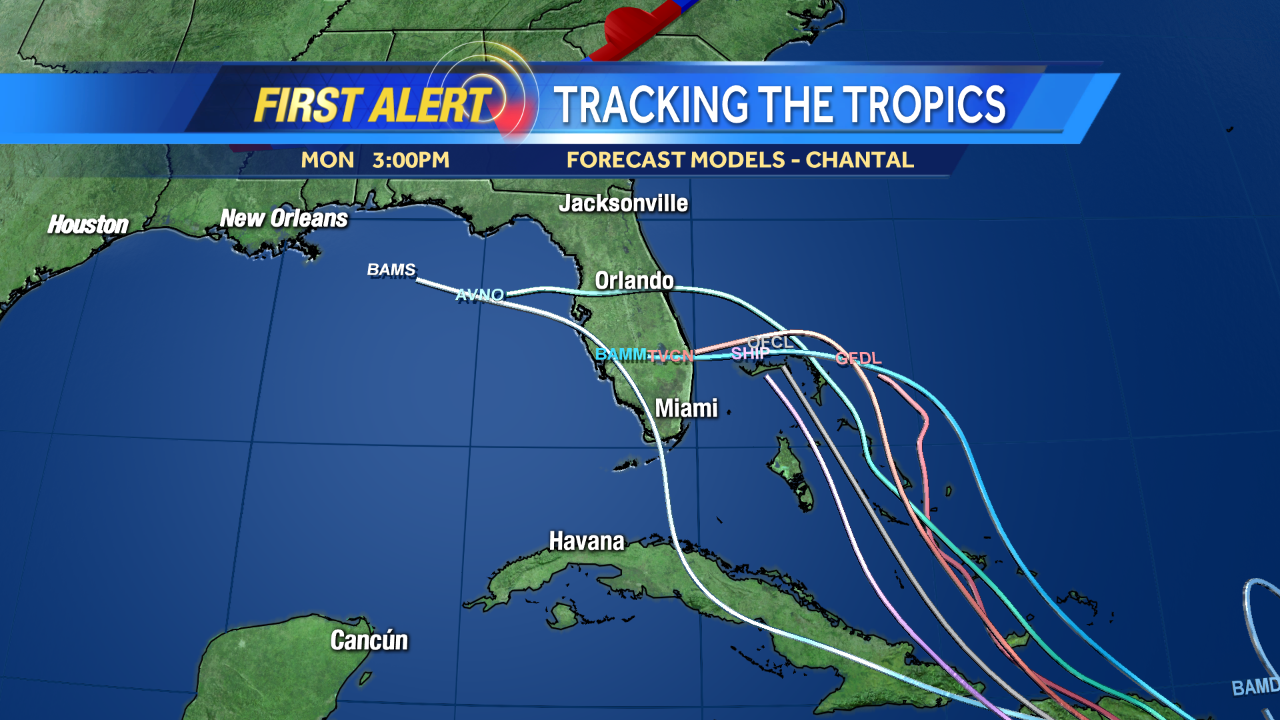
TheStormExpert wrote:Wxman57 earlier today was saying he expects Chantal to enter a much more favorable environment north of the big islands once in the Bahamas, since it will be slowing down.

I had to disagree with 57 on a ton with Chantal so far but this is one thing I agree with, I have a sneaky feeling it won't be in an unfavorable environment when it stalls in the Bahamas.

I like the tight ball and curl on it right now, more convection over the "center"? I'm starting to get Jeanne vibes now based on all the new information, the long-range might be similar to that fate track-wise.
0 likes   

User avatar
TropicalAnalystwx13
Category 5
Category 5
Posts: 2109
Age: 28
Joined: Tue Jul 19, 2011 8:20 pm
Location: Wilmington, NC
Contact:

#1277 Postby TropicalAnalystwx13 » Mon Jul 08, 2013 7:08 pm

The environment for Chantal in the Bahamas depends on how quickly it takes to get there. If it follows the current forecast, it will be endure westerly shear from the ULL that should be over Florida at the time. If it instead takes a little longer than expected, as the GFS shows, than this gives the ULL enough time to back southwest and allow for a favorable shear environment with great outflow channels.
0 likes   

User avatar
sunnyday
Category 5
Category 5
Posts: 1590
Joined: Thu Sep 04, 2003 8:16 pm

Re: ATL: CHANTAL - Models

#1278 Postby sunnyday » Mon Jul 08, 2013 7:09 pm

My friend who lives in WPB called and said that her local tv met said that Chantal will likely miss their area by around 75 miles to the east. Does that sound logical? 8-) 8-)
0 likes   

User avatar
Evil Jeremy
S2K Supporter
S2K Supporter
Posts: 5463
Age: 32
Joined: Mon Apr 10, 2006 2:10 pm
Location: Los Angeles, CA

Re: ATL: CHANTAL - Models

#1279 Postby Evil Jeremy » Mon Jul 08, 2013 7:10 pm

sunnyday wrote:My friend who lives in WPB called and said that her local tv met said that Chantal will likely miss their area by around 75 miles to the east. Does that sound logical? 8-) 8-)


Way way way to early to tell.
0 likes   
Frances 04 / Jeanne 04 / Katrina 05 / Wilma 05 / Fay 08 / Debby 12 / Andrea 13 / Colin 16 / Hermine 16 / Matthew 16 / Irma 17

Syx6sic
Tropical Depression
Tropical Depression
Posts: 84
Age: 41
Joined: Wed Jun 05, 2013 12:11 pm
Location: Virginia beach VA

#1280 Postby Syx6sic » Mon Jul 08, 2013 7:10 pm

They been talking about it here in Norfolk va already this morning telling us we need to keep an eye on it that it may do a turn up this way gotta love how they telling us to get ready atleast a week before it gets close
0 likes   
Personal Forecast Disclaimer:
The posts in this forum are NOT official forecast and should not be used as such. They are just the opinion of the poster and may or may not be backed by sound meteorological data. They are NOT endorsed by any professional institution or storm2k.org. For official information, please refer to the NHC and NWS products.


Return to “2013”

Who is online

Users browsing this forum: No registered users and 1 guest