ATL: Tropical Depression Fay
Moderator: S2k Moderators
-
Extratropical1
- Tropical Low

- Posts: 45
- Joined: Fri Jun 13, 2008 10:14 am
- Location: Spring Hill, Florida
Re: ATL: Tropical Storm Fay over northern Florida Penninsula
Nice here in Hernando County despite Trop Storm warning. Seems to be lifting north (the heavier weather)
0 likes
-
Frank P
- S2K Supporter

- Posts: 2779
- Joined: Fri Aug 29, 2003 10:52 am
- Location: Biloxi Beach, Ms
- Contact:
Re: ATL: Tropical Storm Fay over northern Florida Penninsula
maybe what we're seeing is at the midlevels? not sure
0 likes
-
Extratropical1
- Tropical Low
- Posts: 45
- Joined: Fri Jun 13, 2008 10:14 am
- Location: Spring Hill, Florida
Re: ATL: Tropical Storm Fay over northern Florida Penninsula
Awwww c'mon down. Lot's of room. Not too many storms ever effect us at least in the last 30 years lol
0 likes
Re: ATL: Tropical Storm Fay over northern Florida Penninsula
Frank P wrote:cpdaman wrote:appears center is now near 30.1 83 per visual seems like circuation tightened a bit NW
Yeah, you can see that effect using this radar loop...
http://my.sfwmd.gov/portal/page?_pageid ... ema=PORTAL
looks to be well right (above) of the forecast point
yes per radar 30.0 or such and a bit right of forecast for now, hey she doesn't like water.
maybe mid levels frank good point
0 likes

-
jlauderdal
- S2K Supporter
- Posts: 7240
- Joined: Wed May 19, 2004 5:46 am
- Location: NE Fort Lauderdale
- Contact:
Re: ATL: Tropical Storm Fay over northern Florida Penninsula
x-y-no wrote:jlauderdal wrote:
HE NATL WEATHER SVC IN MIAMI HAS ISSUED A
* TORNADO WARNING FOR.
EAST CNTL BROWARD COUNTY IN SO. FL.
* UNTIL 245 PM EDT
* AT 220 PM EDT.NATL WEATHER SVC DOPPLER RADAR INDICATED A
SEVERE THUNDERSTORM CAPABLE OF PRODUCING A TORNADO NEAR PORT
EVERGLADES.MOVING NE AT 22 MPH.
* THE TORNADO WILL BE NEAR.
PORT EVERGLADES.
LAUDERDALE BY THE SEA.
& SURROUNDING COMMUNITIES.
I'm right in the south end of that line now - It's a pretty good one.
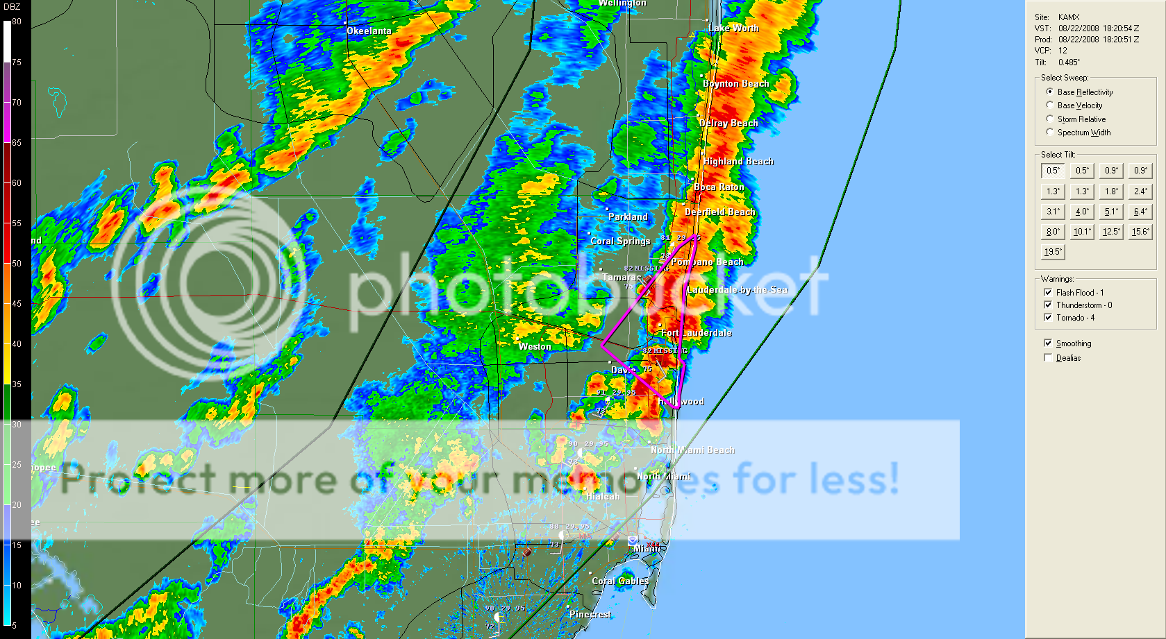
my road has enough flooding that i couldn't drive on it right now, my weather station is showing 2.68 inches in 45 mins
THE NATL WEATHER SVC IN MIAMI HAS ISSUED AN
* URBAN FLOOD ADVISORY FOR.
SOUTHEASTERN BROWARD COUNTY IN SE FL.
THIS INCLUDES THE CITIES OF.POMPANO BEACH.HOLLYWOOD.
HALLANDALE.FORT LAUDERDALE.
* UNTIL 445 PM EDT
* AT 250 PM EDT.NATL WEATHER SVC DOPPLER RADAR INDICATES
THAT OVER 2 INCHES OF RAIN MAY HAVE FALLEN IN PARTS OF SOUTHEASTERN
BROWARD COUNTY OVER A LITTLE MORE THAN THE PAST HOUR. A LINE OF
THUNDERSTORMS WITH VERY HEAVY RAINFALL REMAINS ACROSS THIS AREA AND
COULD PRODUCE UP TO ANOTHER 2 INCHES OF RAIN LOCALLY BEFORE IT MOVES
OFFSHORE. ADDITIONAL SHOWERS & THUNDERSTORMS MAY MOVE IN FROM THE
WEST IN THE NEXT HOUR OR TWO.
THIS HEAVY RAINFALL COULD LEAD TO FLOODING OF AREA ROADWAYS
ESPECIALLY GIVEN THE SATURATED GROUND FROM PREVIOUS DAYS RAIN.
DO NOT DRIVE YOUR VEHICLE INTO AREAS WHERE THE WATER COVERS THE
ROADWAY. THE WATER DEPTH MAY BE TOO GREAT TO ALLOW YOUR CAR TO CROSS
SAFELY. MOVE TO HIGHER GROUND. TURN AROUND, DONT DROWN!
0 likes


-
Frank P
- S2K Supporter
- Posts: 2779
- Joined: Fri Aug 29, 2003 10:52 am
- Location: Biloxi Beach, Ms
- Contact:
Re: ATL: Tropical Storm Fay over northern Florida Penninsula
The circulation and cloud field with Kay is pretty darn big... didn't notice just how big until I looked at IvanH's sat pix.. been focusing on the COC using radar most of the morning... well at least it still looks to be moving towards the west.... hopefully one day in the not to distant future Kay will leave the great state of FL and her 27 electoral votes 
0 likes
-
Enzo Aquarius

- Tropical Storm

- Posts: 160
- Joined: Wed Jul 23, 2008 12:53 pm
- Location: Canada
Re: ATL: Tropical Storm Fay over northern Florida Penninsula
Tornado warnings are gone for the Jacksonville area. The band in the area has moved west and appears to have weakened. A second larger band in the Atlantic, however, appears to be moving in. Miami area is getting hammered by some of the south outer bands of Fay, and boy are they getting hit hard.
0 likes
-
HurricaneHunter914
- Category 5

- Posts: 4439
- Age: 32
- Joined: Fri Mar 10, 2006 7:36 pm
- Location: College Station, TX

Re: ATL: Tropical Storm Fay over northern Florida Penninsula
From various radar sites (KVAX, KJAX, KTLH), it appears to me that the center is near Mayo, FL, or around 30.05N 83.1W. The 0.5 degree elevation angle scan from VAX is ~5000 ft above the surface, so I wouldn't say that's the midlevel center. There's quite a bit of ambiguity, however, since even radar loops don't make it easy to find the exact center of circulation. Heck, if I squint my eyes, I can envision the center being closer to 29.9N. It's likely that there is not one, clear-cut center (obviously), which makes this a little more difficult.
I find the increase in intensity of the two short line segments W and NW of JAX to be rather interesting. We haven't seen too much in the way of 55-60 dBz returns in Fay thus far, so it's likely that those two bands are producing extremely heavy rainfall at this time. Indeed, radar-estimated 1-hour rainfall accumulations are 2-4.5 inches in those bands. Eek. It looks like me like the center may brush the coast, but it certainly doesn't look like the entire center will clear the coast and move over the Gulf. Of course, how one defines the "center" is tough, since there isn't a well-defined inner core like Fay had Tuesday. Geez, to think that Fay moved ashore Monday night / early Tuesday morning, and, three and a half days later, it's still in northern Florida...
EDIT: Fixed position typo.
Last edited by WxGuy1 on Fri Aug 22, 2008 2:36 pm, edited 1 time in total.
0 likes
-
jasons2k

- Storm2k Executive

- Posts: 8290
- Age: 52
- Joined: Wed Jul 06, 2005 12:32 pm
- Location: The Woodlands, TX
Re: ATL: Tropical Storm Fay over northern Florida Penninsula
3-hr rainfall rates piling up:

Shot at 2008-08-22
Shot at 2008-08-22
0 likes
-
Enzo Aquarius
- Tropical Storm
- Posts: 160
- Joined: Wed Jul 23, 2008 12:53 pm
- Location: Canada
Re: ATL: Tropical Storm Fay over northern Florida Penninsula
325 PM EDT FRI AUG 22 2008
THE NATIONAL WEATHER SERVICE IN MIAMI HAS ISSUED A
* SPECIAL MARINE WARNING FOR...
WATERS FROM DEERFIELD BEACH TO OCEAN REEF FL FROM 20 TO 60 NM
EXCLUDING THE TERRITORIAL WATERS OF BAHAMAS
WATERS FROM JUPITER INLET TO DEERFIELD BEACH FL FROM 20 TO 60 NM
COASTAL WATERS FROM DEERFIELD BEACH TO OCEAN REEF FL OUT 20 NM
COASTAL WATERS FROM JUPITER INLET TO DEERFIELD BEACH FL OUT 20 NM
BISCAYNE BAY
* UNTIL 430 PM EDT
* AT 319 PM EDT...NATIONAL WEATHER SERVICE DOPPLER RADAR INDICATED A
LINE OF THUNDERSTORMS...CAPABLE OF PRODUCING STRONG WINDS OF 34
KNOTS OR GREATER FROM 63 NM NORTHEAST OF HALLANDALE TO 5 NM WEST OF
CORAL GABLES... FROM 22 NM EAST OF JUNO BEACH TO 5 NM WEST OF CORAL
GABLES....MOVING EAST AT 13 KNOTS. WATERSPOUTS ARE ALSO POSSIBLE
WITHIN THIS LINE.
0 likes
-
UpTheCreek

- Category 1

- Posts: 397
- Age: 62
- Joined: Tue Aug 31, 2004 5:28 pm
- Location: Vassalboro, Maine
Re: ATL: Tropical Storm Fay over northern Florida Penninsula
WxGuy1 wrote:Geez, to think that Fay moved ashore Monday night / early Tuesday morning, and, three and a half days later, it's still in northern Florida...
It's amazing. Good luck Florida and those westward!
0 likes
-
Frank P
- S2K Supporter
- Posts: 2779
- Joined: Fri Aug 29, 2003 10:52 am
- Location: Biloxi Beach, Ms
- Contact:
Re: ATL: Tropical Storm Fay over northern Florida Penninsula
30.05N 80.1W
You sure of these coordinates?
You sure of these coordinates?
0 likes
-
jlauderdal
- S2K Supporter
- Posts: 7240
- Joined: Wed May 19, 2004 5:46 am
- Location: NE Fort Lauderdale
- Contact:
Re: ATL: Tropical Storm Fay over northern Florida Penninsula
Enzo Aquarius wrote:Tornado warnings are gone for the Jacksonville area. The band in the area has moved west and appears to have weakened. A second larger band in the Atlantic, however, appears to be moving in. Miami area is getting hammered by some of the south outer bands of Fay, and boy are they getting hit hard.


time for a nap before that next line comes through
0 likes
Re: ATL: Tropical Storm Fay over northern Florida Penninsula
Frank P wrote:30.05N 80.1W
You sure of these coordinates?
probably meant 83.1
0 likes
-
Enzo Aquarius
- Tropical Storm
- Posts: 160
- Joined: Wed Jul 23, 2008 12:53 pm
- Location: Canada
Re: ATL: Tropical Storm Fay over northern Florida Penninsula
Water levels at Black Creek near Middleburg and St. Mary's River near Macclenny are rising faster than predicted. St. Mary is 1.52 feet away from Moderate Stage and Black Creek is 2.16 feet from Flood Stage.
0 likes
Re: ATL: Tropical Storm Fay over northern Florida Penninsula
rockyman wrote:Frank P wrote:30.05N 80.1W
You sure of these coordinates?
probably meant 83.1
Oops -- Yes, I meant 83.1 . Not sure where I got 80.1 W -- I'd be the worst tropical cyclone tracker in the world if I thought that!
Maybe a bit west of there now that it took me so long to type up that last post (busy with stuff in-between typing that one out).
Last edited by WxGuy1 on Fri Aug 22, 2008 2:39 pm, edited 1 time in total.
0 likes
-
Frank P
- S2K Supporter
- Posts: 2779
- Joined: Fri Aug 29, 2003 10:52 am
- Location: Biloxi Beach, Ms
- Contact:
Re: ATL: Tropical Storm Fay over northern Florida Penninsula
rockyman wrote:Frank P wrote:30.05N 80.1W
You sure of these coordinates?
probably meant 83.1
yeah 83.1 or 83.2 makes sense, prob just a typo...
0 likes
Who is online
Users browsing this forum: No registered users and 12 guests