Tropical Depression TEN: Discussions & Images

Moderator: S2k Moderators

Message
Author
User avatar
Sjones
Tropical Storm
Tropical Storm
Posts: 168
Joined: Thu May 17, 2007 2:09 pm
Location: Southeast Texas

Re: INVEST 93L: Eastern Gulf : Discussions & Images

#1301 Postby Sjones » Thu Sep 20, 2007 9:50 am

Derek Ortt wrote:that was a hurricane that hit Texas

Also, that guy should not have been standing under his awning... he got the Darwin award for that storm


Extremely distasteful...he might have lost power and didn't even get the warning, and walked outside because he heard heavy rains.
0 likes   

User avatar
jdray
Category 3
Category 3
Posts: 853
Joined: Tue Aug 31, 2004 10:07 pm
Location: NE Florida

Re:

#1302 Postby jdray » Thu Sep 20, 2007 9:53 am

HURAKAN wrote:Image

I just ask, WHY???? Such a messy disturbance right over Florida, going from coast to coast, and only small portion of the state gets rainfall. WHY??? :lol: :lol: :lol:


It was a North Florida rainstorm this time around.
At one point on monday, I-10 and I-95 interchange was flooded, other major roads developed potholes, etc.

We would have gladly shared our bounty.
0 likes   

User avatar
fci
S2K Supporter
S2K Supporter
Posts: 3324
Joined: Tue Sep 14, 2004 10:29 am
Location: Lake Worth, FL

#1303 Postby fci » Thu Sep 20, 2007 9:54 am

If the NHC issued warnings as quick as some of you wish they would here; then the concept of a "warning" would be greatly diminshed.

Save the warnings for true systems that follow the protocol established.

If you really want warnings for winds of 40 or so; then issue them DAILY for many areas in the summer because there is a much better chance of them occuring with summer thunderstorms!

I just can't see the excitement here for something that isn't even a Tropical Depression yet.
0 likes   

User avatar
HURAKAN
Professional-Met
Professional-Met
Posts: 46086
Age: 38
Joined: Thu May 20, 2004 4:34 pm
Location: Key West, FL
Contact:

Re: INVEST 93L: Eastern Gulf : Discussions & Images

#1304 Postby HURAKAN » Thu Sep 20, 2007 9:54 am

Sjones wrote:
Derek Ortt wrote:that was a hurricane that hit Texas

Also, that guy should not have been standing under his awning... he got the Darwin award for that storm


Extremely distasteful...he might have lost power and didn't even get the warning, and walked outside because he heard heavy rains.


It's a fact that most people that die in a hurricane die after the storm because they went outside to check. Human curiosity always gets the best of you, and you should never do something like that.
0 likes   

User avatar
CypressMike
Tropical Low
Tropical Low
Posts: 41
Joined: Mon Aug 20, 2007 2:28 pm
Location: Cypress, TX
Contact:

Re:

#1305 Postby CypressMike » Thu Sep 20, 2007 9:55 am

Derek Ortt wrote:that was a hurricane that hit Texas

Also, that guy should not have been standing under his awning... he got the Darwin award for that storm


Given the likely landfall point of SE LA (a fairly fragile area), I have to respectfully disagree with taking this potential storm too lightly. I agree that 6 hours is plenty of time to prepare for a weak TS. However, what if we are surprised and it pulls an Humberto and goes in as a strong Cat 1? Would you want to be the one that missed that call?

Like someone else who recently posted, I'm looking at this from an engineering point of view. I'm also very experienced in running dynamic 3-D finite-difference simulations, so I am aware of limitations of such models.
0 likes   

User avatar
Cookiely
S2K Supporter
S2K Supporter
Posts: 3211
Age: 74
Joined: Fri Aug 13, 2004 7:31 am
Location: Tampa, Florida

Re: INVEST 93L: Eastern Gulf : Discussions & Images

#1306 Postby Cookiely » Thu Sep 20, 2007 9:56 am

I thank you 93L for providing a couple of cloudy days to get out and do some yard work without having a heat stroke.
0 likes   

User avatar
Steve
S2K Supporter
S2K Supporter
Posts: 9621
Joined: Sat Apr 05, 2003 11:41 pm
Location: Not a state-caster

#1307 Postby Steve » Thu Sep 20, 2007 9:56 am

Distasteful or not, I thought it was funny. :)

Anyway:

>>That's exactly what one would expect from a slowly transitioning hybrid system. Continued patience is in order and I think overnight tonight into tomorrow we'll know what 93 is going to do.

That says it all in the proverbial nutshell. Schlitz, what do you think about the early cycle 12z guidance I posted earlier? WIth a slow transition, I could see something a little more solid hitting South Central or S LA than a 40k STS/TS. I think we've been in agreement for about 24 hours on this thing. It could be a coast rider, or it may move wnw inland, but there should be ample Gulf moisture from which to draw.

Steve
0 likes   

Derek Ortt

Re: INVEST 93L: Eastern Gulf : Discussions & Images

#1308 Postby Derek Ortt » Thu Sep 20, 2007 9:57 am

I get the feeling that some here would have the entire USA under a hurricane warning for the entire season

also, I am very glad we have the ignore feature
0 likes   

Zardoz
Category 1
Category 1
Posts: 309
Joined: Fri Aug 25, 2006 9:48 am
Location: Severe weather-challenged Southern California

Re: INVEST 93L: Eastern Gulf : Discussions & Images

#1309 Postby Zardoz » Thu Sep 20, 2007 9:58 am

I sure hope all who are writing 93L off are correct. I sure hope it doesn't have any terrible surprises in store for those in its path.

Sitting here staring at the various versions of the sat images, and remembering what other systems have done this season, one has to wonder...
0 likes   

User avatar
HURAKAN
Professional-Met
Professional-Met
Posts: 46086
Age: 38
Joined: Thu May 20, 2004 4:34 pm
Location: Key West, FL
Contact:

#1310 Postby HURAKAN » Thu Sep 20, 2007 9:58 am

Every time any kind of warning or watch is issued, money is being spended because authorities need to get ready to handle the problems a storm brings. If you start issuing watches and warning just because it may develop, first, money is going to be wasted most of the time, and second, people are going to get more frustrated every time they are told to prepare and nothing happens.
0 likes   

rockyman
Category 5
Category 5
Posts: 1967
Joined: Thu Jun 26, 2003 12:24 pm
Location: Dauphin Island, AL

#1311 Postby rockyman » Thu Sep 20, 2007 9:58 am

yeah...I just don't see why we aren't ALL laughing that an 80 year old man was killed by Humberto...good grief, people...have a heart
0 likes   

Derek Ortt

#1312 Postby Derek Ortt » Thu Sep 20, 2007 9:59 am

the chances of this doing what Humberto did are almost nil

Two totally different atmospheric set-ups (Humberto in the proper location of the trough while this is directly underneath a UL
0 likes   

User avatar
Steve
S2K Supporter
S2K Supporter
Posts: 9621
Joined: Sat Apr 05, 2003 11:41 pm
Location: Not a state-caster

#1313 Postby Steve » Thu Sep 20, 2007 10:00 am

>>If you really want warnings for winds of 40 or so; then issue them DAILY for many areas in the summer because there is a much better chance of them occuring with summer thunderstorms!

Some of the FEMA trailers are tied in. Some are on cinder blocks. There's plenty of debris everywhere that can blow around. My ex already told me she would be heading to one of her friend's houses to ride out the TS if necessary. You never know what a 50 or 60 gust can do. It's probably not going to flip a trailer, but unless I was really drunk, I don't think I'd want to risk riding things out in one - not to mention the possibility of falling tree limbs that could easily pierce a roof of a FEMA or travel trailer.

JMO

Steve
0 likes   

curtadams
S2K Supporter
S2K Supporter
Posts: 1122
Joined: Sun Aug 28, 2005 7:57 pm
Location: Orange, California
Contact:

Re: INVEST 93L: Eastern Gulf : Discussions & Images

#1314 Postby curtadams » Thu Sep 20, 2007 10:00 am

It looks on RGB as if the central FL low did NOT die. It moved offshore. There's a fairly strong, and fairly obvious, boundary layer low in the Gulf west of Tampa. It's actually dominating the low formed by the convection in the center of the ULL last night. This is contributing to the "disorganized" appearance, since you have multiple lows at some distance from one another.
0 likes   

User avatar
HURAKAN
Professional-Met
Professional-Met
Posts: 46086
Age: 38
Joined: Thu May 20, 2004 4:34 pm
Location: Key West, FL
Contact:

Re: INVEST 93L: Eastern Gulf : Discussions & Images

#1315 Postby HURAKAN » Thu Sep 20, 2007 10:00 am

Zardoz wrote:I sure hope all who are writing 93L off are correct. I sure hope it doesn't have any terrible surprises in store for those in its path.

Sitting here staring at the various versions of the sat images, and remembering what other systems have done this season, one has to wonder...


No one is writing 93L off, but pro-Mets and most here don't want to make a big deal of something that just has some potential. It's not the time to be running around but to just watch and wait.
0 likes   

miamicanes177
Category 5
Category 5
Posts: 1131
Joined: Tue Aug 01, 2006 10:53 pm

Re: INVEST 93L: Eastern Gulf : Discussions & Images

#1316 Postby miamicanes177 » Thu Sep 20, 2007 10:01 am

Derek Ortt wrote:I get the feeling that some here would have the entire USA under a hurricane warning for the entire season

also, I am very glad we have the ignore feature

Please get back on topic to what the thread is about which is 93L. Thank you.
0 likes   

User avatar
HURAKAN
Professional-Met
Professional-Met
Posts: 46086
Age: 38
Joined: Thu May 20, 2004 4:34 pm
Location: Key West, FL
Contact:

#1317 Postby HURAKAN » Thu Sep 20, 2007 10:01 am

Latest:

Image
0 likes   

Derek Ortt

#1318 Postby Derek Ortt » Thu Sep 20, 2007 10:03 am

we need to keep this situation in perspective

What we are likely facing is a rain event with gusty winds. Those living near rivers need to closely monitor, but for the rest of us, it should just be a miserable day with severe weather

Perhaps a way to better address the warning criteria would be to abolish TS warnings, and issue gale (34-47KT and storm (48-63KT) warnings. That way, there would be a difference between the weak and strong TS
0 likes   

Air Force Met
Military Met
Military Met
Posts: 4372
Age: 56
Joined: Tue Jul 08, 2003 9:30 am
Location: Roan Mountain, TN

Re: INVEST 93L: Eastern Gulf : Discussions & Images

#1319 Postby Air Force Met » Thu Sep 20, 2007 10:04 am

CoCo2 wrote:Yeah Derek, the weather pros said that about Cindy in 2005, just a thunderstorm, no big deal... well Miss Cindy went right over me, and while Cindy was no Katrina, she scared the bejeezes out of me.


Come on now...let's not be dramatic. No pro said cindy was just a thunderstorm or no big deal.

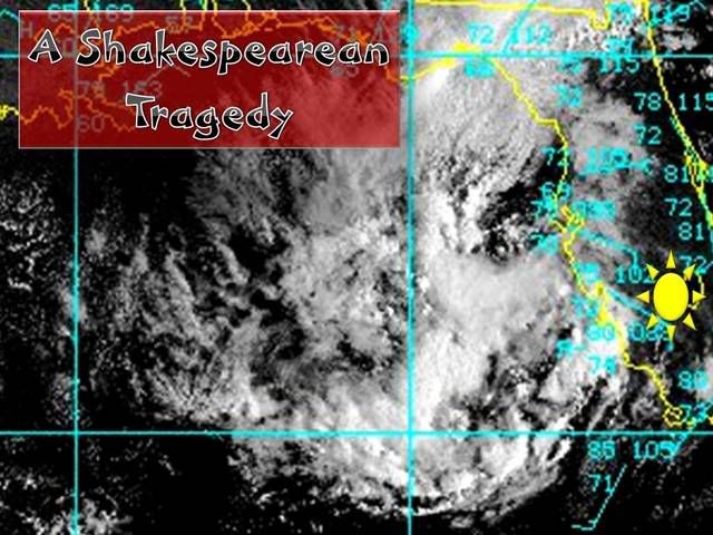
A TROPICAL STORM WARNING IS IN EFFECT FROM MORGAN CITY LOUISIANA
EASTWARD TO DESTIN FLORIDA...AND A TROPICAL STORM WATCH IS IN
EFFECT EAST OF DESTIN TO INDIAN PASS FLORIDA.

A TROPICAL STORM WARNING MEANS THAT TROPICAL STORM CONDITIONS ARE
EXPECTED WITHIN THE WARNING AREA WITHIN THE NEXT 24 HOURS.

MAXIMUM SUSTAINED WINDS ARE NEAR 70 MPH...WITH HIGHER GUSTS (to 85 mph per the forecast advisory)REPORTS FROM OIL PLATFORMS AND COASTAL OBSERVING STATIONS AT 150 FT ABOVE THE SURFACE HAVE INDICATED WINDS IN EXCESS OF 70 MPH HAVE BEEN OCCURRING DURING THE PAST FEW HOURS. TROPICAL STORM FORCE WINDS EXTEND OUTWARD UP TO 105 MILES FROM THE CENTER.

That is not a thunderstorm. Thunderstorms don't have winds to 85 MPH (severe Tstms do) with other winds over 40 that extend over a 170 miles area (SE-NW). ;-)
0 likes   

jlauderdal
S2K Supporter
S2K Supporter
Posts: 7182
Joined: Wed May 19, 2004 5:46 am
Location: NE Fort Lauderdale
Contact:

Re:

#1320 Postby jlauderdal » Thu Sep 20, 2007 10:05 am

HURAKAN wrote:BACK ON TOPIC:

Image

Humidity is increasing in South Florida, lets see if we can get some thunderstorms this afternoon.


i have seen some lightning early in the morning the last few days but no rain
0 likes   


Return to “2007”

Who is online

Users browsing this forum: No registered users and 16 guests