ATL: IKE Discussion
Moderator: S2k Moderators
-
THead
- S2K Supporter

- Posts: 790
- Joined: Mon Aug 30, 2004 5:09 pm
- Location: Lauderhill, Fla./Jefferson, Ga.
Re: ATL IKE: Tropical Depression - Discussion
Thanks all for the ongoing Ike reports, my dad lives in South Bend, Indiana, looks like they'll be close to the center as Ike passes, and they already got almost 7 inches of rain there yesterday. Thanks for all the info, keep it coming please!
0 likes
-
expat2carib

- S2K Supporter
- Posts: 458
- Joined: Tue Jul 22, 2008 1:44 pm
- Location: Sint Maarten
Re: ATL IKE: Tropical Depression - Discussion
Sat. 13th Sept
It has now been revealed that the 1,300 inmates at Galveston Jail were forced to stay in the Galveston area during the hurricane, according to a news report in the HERALD TRIBUNE today.
Other reports state that the water levels reached six-feet high in the adjoining Court House and that there is no power or running water, with orders from the authorities to boil all water in Galveston before drinking it. The power outage is expected to be the longest in history for the state.
US Government authorities have expressed their concern for the well-being of residents who remained in the coastal region during the worst storm in Texas in fifty years. Although Galveston Jail is described as "hurricane-proof" it is only one storey high.
A large number of the inmates are on remand and not (yet) convicted of any crime and many are in there for minor larcenies.
http://www.nowpublic.com/world/galveston-jail-scandal-1-300-inmates-locked-hurricane-death-zone-water-six-feet-high
NHC statement was that people that were staying on Galveston would face a certain death. Did all these prisoners get a dead sentence?
0 likes
-
Pebbles

- S2K Supporter
- Posts: 1994
- Joined: Tue Jul 08, 2003 1:42 pm
- Location: New Lenox, IL (SW of Chicago)
vbhoutex, those pictures are amazing... Reminds me of the morning we had the microburst come through here last year. I can just imagine the reaction of you/the neighbors as you guys came out. Thankfully most of it can be cleaned up in fairly short order once the woodchipping trucks start coming through.
Glad to hear you and your family are safe.
Glad to hear you and your family are safe.
0 likes
-
HURAKAN

- Professional-Met

- Posts: 46084
- Age: 39
- Joined: Thu May 20, 2004 4:34 pm
- Location: Key West, FL
- Contact:
Re: ATL IKE: Tropical Depression - Discussion
Hurricane Ike flattens homes in Texas
Staff writer
September 15, 2008 12:00am
Rescuers picked through devastation in Texas yesterday after Hurricane Ike wreaked havoc.
The storm flattened hundreds of homes, flooded barrier islands and knocked out power to millions.
The hurricane cut a swath of destruction across 800km of the coast, largely cut off oil and gas production in the Gulf of Mexico, and caused at least $US8 billion onshore damage.
In Galveston, street after street was filled with water more than 12 hours after the storm passed.
Windows were blown out of flooded homes, swamped furniture lay in the streets and tree branches littered roadways.
President George W. Bush declared a major disaster in Texas and parts of Louisiana.
Some deaths were reported, Homeland Security Secretary Michael Chertoff said, but Texas Governor Rick Perry was optimistic his state had been spared the worst.
More than 2.2 million people fled inland but more than 100,000 residents of low-lying areas - 20,000 in Galveston alone - decided to ride out the storm, despite warnings a wall of water up to 6m high could spell "certain death".
"Fortunately, the worst-case scenario that was projected in some areas did not occur, particularly in the Houston ship channel," Mr Perry said.
"But there is plenty of damage out there."
The centre of Ike made landfall as a category two hurricane on Galveston Island early yesterday morning, where the sea swelled up in fury, whipping the country's fourth-largest city, Houston.
Mr Perry announced Texas and federal agencies had launched the state's largest search-and-rescue operations just hours after Ike hit.
Live television images along large areas of the Texas coast, including Galveston and nearby Clear Lake, showed boats tossed about like toys, electricity poles and oak trees snapped or uprooted, walls shorn off homes, and water covering neighbourhoods.
Strong wind and rain raked Houston, home to the port, key refineries and a metro area of more than five million.
At the landmark Chase Tower, the tallest building in Texas, windows were blown off most of one face of the building, while glass, furniture and computers rained on streets below.
"I was watching furniture come out of the 20th floor," resident David Foreman said.
Australian couple Tim Withall and wife Kate abandoned plans to spend the night at a Houston Hurricane party with friends.
When the first powerful gusts from Ike shook the friend's house as the party raged on, the Withalls decided to head back to their own apartment in Houston's midtown area.
"We thought it would be the best thing to do," said Mr Withall, 29, who moved with Kate, 27, from Adelaide to work for an engineering firm.
They braced in an alcove near a bathroom, away from windows, as Ike hit.
"From about 3am to 4am it was pretty wild," Mr Withall said.
"The building shook, the rain was hitting the windows horizontally. It was like someone was throwing gravel or nails at the windows.
"We don't get hurricanes in Adelaide so we have never experienced anything like it."
An engineer who ran a red stop signal caused the collision between two trains near Los Angeles on Saturday, officials said yesterday as the death toll rose to 25.
0 likes

Re: ATL IKE: Tropical Depression - Discussion
Matt-hurricanewatcher wrote:SPECI KPOF 141201Z AUTO 20035G57KT
This adds support to my thinking that Ike is still a tropical storm...
Ike is likely extratropical at this point. The wind field behind Ike (and the frontal boundary Ike is riding along) has increased over the last 12 hours or so. The wind increase across Missouri and the lower OH Valley is likely baroclinic in nature...which is a sign this is likely not a pure tropical system at this point.
0 likes
-
Wx_Warrior
- Category 5

- Posts: 2718
- Joined: Thu Aug 03, 2006 3:58 pm
- Location: Beaumont, TX
Re: ATL IKE: Tropical Depression - Discussion
These are photos from Bridge City, Texas....Little community south of Orange.
http://kogt.smugmug.com/gallery/5953607_Nn2hu#371134406_jLgnE
http://kogt.smugmug.com/gallery/5953607_Nn2hu#371134406_jLgnE
0 likes
-
HarlequinBoy

- Category 5
- Posts: 1400
- Age: 35
- Joined: Wed Nov 29, 2006 1:57 am
- Location: Memphis

Re: ATL IKE: Tropical Depression - Discussion
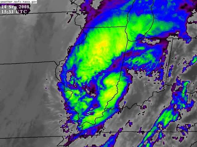
Looks like the center of circulation passed near Carbondale and Mt Vernon IL

0 likes
-
senorpepr

- Military Met/Moderator

- Posts: 12542
- Age: 43
- Joined: Fri Aug 22, 2003 9:22 pm
- Location: Mackenbach, Germany
- Contact:
Re: Re:
CrazyC83 wrote:HURAKAN wrote:HPC 10 AM CDT:
REPEATING THE 1000 AM CDT POSITION...39.0 NORTH...AND LONGITUDE
89.0 WEST. MAXIMUM SUSTAINED WINDS...35 TO 40 MPH. MINIMUM CENTRAL
PRESSURE...987 MB.
Notice they use the 35 mph (wrong!) to keep it a TD.
They are not "keeping it a TD." It's the remnants of Ike. Ike is now extratropical. No "tropical depression" or "tropical storm." Just extratropical. You can see the interaction with the front nearby.
I saw you earlier post the following on the chatroom: "sorry, but Ike is NOT a tropical depression... they do not produce 70 mph gusts." Actually, they can. Remember the maximum sustained surface winds is what gives a cyclone it's status. The gusts, in many cases, are higher winds aloft being brought down to the surface by means of convection and frictional forces.
I'm sorry, but I think the NHC and HPC handled this quite well.
0 likes

TX--Ike-Texas (Tops),0163
It's race against time to save Texas stalwarts
GALVESTON, Texas (AP) _ The death toll from Hurricane Ike has
now reached seven, and officials fear it could climb.
Authorities today day three people were found dead in Galveston,
including one person found in a submerged vehicle near the airport.
That's after four fatalities were reported yesterday, two in
Texas and two in Louisiana.
Rescue crews are again canvassing neighborhoods today that were
inundated by Hurricane Ike's storm surge.
They're racing against time to save those who spent a second
harrowing night trapped in the wreckage of flattened houses, strewn
debris and downed power lines.
A weeklong curfew daily from 9 p.m. to 6 a.m. has been announced
for Houston. Most of the nation's fourth-largest city is still
without power. And the weather hasn't been cooperating along the
Southeast Texas coast today. Showers dropped heavy rain on areas
already flooded by Ike, and forecasters said there was a chance
thunderstorms could continue into the evening.
(Copyright 2008 by The Associated Press. All Rights Reserved.)
APTV 09-14-08 1223EDT
0 likes
-
Category 5

- Category 5
- Posts: 10074
- Age: 36
- Joined: Sun Feb 11, 2007 10:00 pm
- Location: New Brunswick, NJ
- Contact:
Re: Re:
CrazyC83 wrote:HURAKAN wrote:
From Ike to Illinois!
That almost looks like an eye trying to form!

That's a good one. It's going Erin on us!
Still well defined though.
0 likes

Re: Re:
senorpepr wrote:CrazyC83 wrote:HURAKAN wrote:HPC 10 AM CDT:
REPEATING THE 1000 AM CDT POSITION...39.0 NORTH...AND LONGITUDE
89.0 WEST. MAXIMUM SUSTAINED WINDS...35 TO 40 MPH. MINIMUM CENTRAL
PRESSURE...987 MB.
Notice they use the 35 mph (wrong!) to keep it a TD.
They are not "keeping it a TD." It's the remnants of Ike. Ike is now extratropical. No "tropical depression" or "tropical storm." Just extratropical. You can see the interaction with the front nearby.
I saw you earlier post the following on the chatroom: "sorry, but Ike is NOT a tropical depression... they do not produce 70 mph gusts." Actually, they can. Remember the maximum sustained surface winds is what gives a cyclone it's status. The gusts, in many cases, are higher winds aloft being brought down to the surface by means of convection and frictional forces.
I'm sorry, but I think the NHC and HPC handled this quite well.
I am fascinated by all this, can you explain why its forecasted to become a tropical storm once it reaches Canada?
0 likes
-
CrazyC83
- Professional-Met
- Posts: 34316
- Joined: Tue Mar 07, 2006 11:57 pm
- Location: Deep South, for the first time!
Re: Re:
Viper54r wrote:I am fascinated by all this, can you explain why its forecasted to become a tropical storm once it reaches Canada?
I posted that before reading that it went extratropical...although it is hard to tell based on satellite observations since the fronts don't appear connected to the system (the southern tail is not connected at all based on satellite and radar observations and the eastern tail seems more to be convection-related) and there isn't a clear temperature gradient change between the east and west sides of the storm. It is hard to classify at this point IMO...it almost looks like Ike ate up the previous low (or vice versa).
0 likes
-
curtadams
- S2K Supporter
- Posts: 1122
- Joined: Sun Aug 28, 2005 7:57 pm
- Location: Orange, California
- Contact:
It's not forecast to be tropical, it's forecast to be "warm core", i.e. have warmer air towards the center. This often happens towards the end of a nontropical storm's life, and just indicates the storm has brought warm air into a colder area. The warm core is caused by transport, not by convection from warm water, so it's not considered tropical.
0 likes
Re: ATL IKE: Tropical Storm - Discussion
TreasureIslandFLGal wrote:This is something I am only going to mention once, then not again, because it is a very bad thing that I realized and brings up bad memories.
We all know that like 40% of the population on those barrier islands opted to stay, as estimated from emergency personnel and even teh Mayor herself. We all woke to very few pictures and flyby's being shown, except for from high above.
We still are seeing very few aerial shots, unlike Katrina, when we saw many by now of many areas.
There may be a grizzly reason behind that.
You can't show bodies on tv. Joe Public can't see that. Congress can't see blood.
Before any of the footage can get out, it must be prescreened to ensure that they are not going to break the law and show any dead bodies floating.
With all those that stayed behind, with their innocent children, there would be a high likelikhood that some did not make it through the surge.
Haven't read far enough in the thread to see if anyone has corrected you, but there is NO LAW against showing dead bodies floating.
0 likes
Re: ATL IKE: Remmants - Discussion
Seein' how I have read *every* single page on this thread, I'm pretty sure i saw this posted pages ago but for those that are interested but overwhelmed, The Austin American Statesman has reporters out in the affected areas twittering in reports and photos
TrackingIke
TrackingIke
0 likes
-
TreasureIslandFLGal

- S2K Supporter
- Posts: 1584
- Age: 58
- Joined: Sun Aug 15, 2004 6:16 pm
- Location: Cancun, Mexico (northeast Yucatan coast)
Re: ATL IKE: Tropical Storm - Discussion
Windy wrote:TreasureIslandFLGal wrote:This is something I am only going to mention once, then not again, because it is a very bad thing that I realized and brings up bad memories.
We all know that like 40% of the population on those barrier islands opted to stay, as estimated from emergency personnel and even teh Mayor herself. We all woke to very few pictures and flyby's being shown, except for from high above.
We still are seeing very few aerial shots, unlike Katrina, when we saw many by now of many areas.
There may be a grizzly reason behind that.
You can't show bodies on tv. Joe Public can't see that. Congress can't see blood.
Before any of the footage can get out, it must be prescreened to ensure that they are not going to break the law and show any dead bodies floating.
With all those that stayed behind, with their innocent children, there would be a high likelikhood that some did not make it through the surge.
Haven't read far enough in the thread to see if anyone has corrected you, but there is NO LAW against showing dead bodies floating.
Unless something has changed since I was in the military and tasked with reviewing war photos for release to the press, it is still illegal according to FCC regulations.
If the body's face is covered and there is no way to identify it, then it can be shown. However, faces can not be shown, nor any identifier, prior to family notification and release.
Aerial shots, which may possibly be zoomed in on to reveal a body that is identifiable, can not be released until professionally zoomed and gone through with microscopes to verify that no body is in the photo.
However, in the age of the internet, there are rogue photographers and people using cell phones to capture pictures and distribute them, however, it is still illegal. Families could file suit.
Any true news source did not post bodies that were identifiable in any way. The ones from Katrina were all covered, at least their faces, or blurred to prevent identification.
Point is, media is slow to show aerials of general areas until the photos can be properly screened. I was providing reason behind why the info is slow to come out.
Chrissy
0 likes

Re: ATL IKE: Tropical Storm - Discussion
soonertwister wrote:jopatura wrote:Thats odd...Sounds like a Coverup to me. What is there that could be dangerous for a typical no fly zone?They aren't allowing planes to fly where the air traffic control can't see them. A lot of the towers between Houston and the coast are gone or destroyed. It's why even the major airports can't fly out right now.ATC @ Houston airports should have no problem picking them up on radar?
IDK, all I've heard is that even the big commercial planes can't fly because of gaps in the ATC. From what I understand of the system (and I may be wrong) that there are unmanned towers that funnel the radar images into Houston and that is what's down right now.
Houston ATC should be able to get the entire radar picture for a long way around the airport without any auxilliary radar setups. This sounds like an excuse, not a reason. Radar anywhere in Houston metro should be able to see well out into the Gulf. If you aren't in the larger area around Houston metro, you are either in uncontrolled airspace or in another ATC jurisdiction, with the exception of well-known no-fly zones, such as military bases.
all these conspiracy theories so early are for the birds, in my opinion. There is video you can see of all of Galveston taken by our bravest from the day of the storm right here -
http://www.youtube.com/watch?v=lvLCGvPP ... re=related
as well as other areas in which they also did fly overs such as Bolivar Peninsula, etc.
I have heard, just as most of you have, that there has been devastating flooding in many areas. And, even if they do want the news to stay out, there could be good reason. On a coast guard flyover they allowed a reporter to fly along that was shown on channel 2 out of Houston and they had to cut the audio because of the insensitive remarks being made by the reporter - such as "Oh look, he is about to jump!" and then laughing and saying he was just kidding, etc., there wasn't really anyone. The media is sensationalist for the most part anymore and would be hyping if they did see bodies or if they didn't. Just my take on things.
At that link you can see the devastation without all the added commentary.
0 likes
-
PurdueWx80
- Professional-Met
- Posts: 2720
- Joined: Fri Aug 13, 2004 8:33 pm
- Location: Madison, WI
- Contact:
just talked to my sister in louisville, ky, and she said it's nearly impossible to travel through the city now. trees and powerlines down EVERYWHERE, more than in any thunderstorm she's ever seen. a lot of the city is without power, too.
starting to believe those hurricane-force gusts over the great lakes the GFDL was advertising. there have already been gusts to 70 mph over the lower ohio valley.
starting to believe those hurricane-force gusts over the great lakes the GFDL was advertising. there have already been gusts to 70 mph over the lower ohio valley.
0 likes
Who is online
Users browsing this forum: No registered users and 56 guests