ENSO Updates (2007 thru 2023)
Moderator: S2k Moderators
Forum rules

The posts in this forum are NOT official forecasts and should not be used as such. They are just the opinion of the poster and may or may not be backed by sound meteorological data. They are NOT endorsed by any professional institution or STORM2K. For official information, please refer to products from the National Hurricane Center and National Weather Service.
-
Kingarabian

- S2K Supporter

- Posts: 16360
- Joined: Sat Aug 08, 2009 3:06 am
- Location: Honolulu, Hawaii
Re: ENSO Updates
No disrespect to Andy Hazleton, but this event wont get to super Nino levels with this atompshere.
6 likes
RIP Kobe Bryant
Re: ENSO Updates
Kingarabian wrote:No disrespect to Andy Hazleton, but this event wont get to super Nino levels with this atompshere.
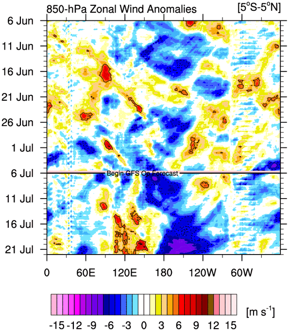
"Already super going by eastern regions" isn't a very good statement. The eastern region can be warm even during La Nina (ie. 1998) and nino3.4 is used precisely because it provides better correlation to the atmosphere due to the warmer base state. The global ENSO teleconnections in particular depend far more on what is happening in that 3.4 region than near the Galapagos and Peru. I went back and looked at every El Nino that had a trimonthly of 2.0C or higher (1965, 1972, 1982, 1997, 2015) and cannot find a single one with weaker westerly wind anomalies near the dateline than current. 2012 and 2014 were very warm in the east, and we know what happened those years. Not saying that will be the case this year (highly unlikely to be a complete bust as SSTs are warmer). AMJ came in at 0.5C and while most upcoming Ninos that had that value turned out to be strong to super, that period is still within the spring predictability barrier and correlation to peak is probably not that robust (compared to correlation between August and January). A strong peak like 1991 is hinted at by the models and is what I personally think is the most likely scenario, but atmospheric coupling was already much stronger by this time during that year. If coupling occurs after this new WWB, then the event may have a chance of becoming quite impressive. If no coupling until late summer or fall then I could see this event peaking as only a moderate. That said, if you look at the map of real SSTs rather than anomalies, it isn't exactly surprising that we aren't seeing frequent big WWBs. The warmest waters of the equatorial Pacific continue to be near Indonesia (albeit a bit to the east). By this time in 1997, with the combination of negative anomalies in the west and positive anomalies in the east, the warmest actual sea surface temperatures were displaced all the way to around 150W; hence a fairly continuous sequence of WWB extending to the end of the year. We have positive anomalies in the far west currently. While this means that there is still gas in the tank so to speak, it doesn't help move the convection eastward.
7 likes
All posts by Dean_175 are NOT official forecasts and should not be used as such. They are just the opinion of the poster and may or may not be backed by sound meteorological data. They are NOT endorsed by any professional institution or storm2k.org. For official information, please refer to the NHC and NWS products.
Re: ENSO Updates
Lol, May-June MEI came in to be 0.2. At the same time for 1997 and 2015, they were 2.4 and 1.7 respectively. The atmosphere is still far from El Nino, let alone super Nino.
2 likes
-
Yellow Evan

- Professional-Met

- Posts: 16238
- Age: 27
- Joined: Fri Jul 15, 2011 12:48 pm
- Location: Henderson, Nevada/Honolulu, HI
- Contact:
Re: ENSO Updates
MEI of .2 continues the trend of steady improvement considering it was -.7 as late as FM. Its not far from El Niño but yea the atmospheric coupling will generally continue to lag behind SSTs.
2 likes
-
dexterlabio
- Category 5

- Posts: 3506
- Joined: Sat Oct 24, 2009 11:50 pm
Re: ENSO Updates
Imagine if the atmosphere starts to fully cooperate by the end of the year like what happened in 2014. 
1 likes
Personal Forecast Disclaimer:
The posts in this forum are NOT official forecast and should not be used as such. They are just the opinion of the poster and may or may not be backed by sound meteorological data. They are NOT endorsed by any professional institution or storm2k.org. For official information, please refer to the NHC and NWS products.
The posts in this forum are NOT official forecast and should not be used as such. They are just the opinion of the poster and may or may not be backed by sound meteorological data. They are NOT endorsed by any professional institution or storm2k.org. For official information, please refer to the NHC and NWS products.
-
Kingarabian
- S2K Supporter
- Posts: 16360
- Joined: Sat Aug 08, 2009 3:06 am
- Location: Honolulu, Hawaii
Re: ENSO Updates
CFS has a WWB reaching 180 by July 21 but stops there. Shows much stronger strades over the CPAC during August.
GFS and Euro have a strong trade burst over the CPAC by July 21.
GFS and Euro have a strong trade burst over the CPAC by July 21.
1 likes
RIP Kobe Bryant

-
Yellow Evan
- Professional-Met
- Posts: 16238
- Age: 27
- Joined: Fri Jul 15, 2011 12:48 pm
- Location: Henderson, Nevada/Honolulu, HI
- Contact:
Re: ENSO Updates
SFLcane wrote:https://i.postimg.cc/6353p82G/sst.png
GFS keeps predicting really strong CPAC trades anytime intraseasonal forcing gets over the MC and while conceptually this makes sense, they never verify at the extent modeled.
1 likes
-
Kingarabian
- S2K Supporter
- Posts: 16360
- Joined: Sat Aug 08, 2009 3:06 am
- Location: Honolulu, Hawaii
Re: ENSO Updates
Yellow Evan wrote:SFLcane wrote:https://i.postimg.cc/6353p82G/sst.png
GFS keeps predicting really strong CPAC trades anytime intraseasonal forcing gets over the MC and while conceptually this makes sense, they never verify at the extent modeled.
MJO/-CCKW over the MC during the summer almost always leads to strong CPAC trades. Euro agrees with the GFS as well.
2 likes
RIP Kobe Bryant


Re: ENSO Updates
The eastern regions continue to warm, while the western regions remains flat, we're seeing a lot more of the same. 3.4 may go back to 1C come Monday's update.


3 likes
The above post and any post by Ntxw is NOT an official forecast and should not be used as such. It is just the opinion of the poster and may or may not be backed by sound meteorological data. It is NOT endorsed by any professional institution including Storm2k. For official information, please refer to NWS products.
Help support Storm2K!
-
dexterlabio
- Category 5
- Posts: 3506
- Joined: Sat Oct 24, 2009 11:50 pm
Re: ENSO Updates
Are the forecasted strong trades supposed to cool down the Nino regions? Because there had been a handful of forecasts showing strong trades particularly in the eastern Nino regions, but the temperature has been holding steady at least. Nino 1.2 has been hovering between 2.6C and 2.9C since last Spring.
0 likes
Personal Forecast Disclaimer:
The posts in this forum are NOT official forecast and should not be used as such. They are just the opinion of the poster and may or may not be backed by sound meteorological data. They are NOT endorsed by any professional institution or storm2k.org. For official information, please refer to the NHC and NWS products.
The posts in this forum are NOT official forecast and should not be used as such. They are just the opinion of the poster and may or may not be backed by sound meteorological data. They are NOT endorsed by any professional institution or storm2k.org. For official information, please refer to the NHC and NWS products.
-
USTropics
- Professional-Met
- Posts: 2738
- Joined: Sun Aug 12, 2007 3:45 am
- Location: Florida State University
Re: ENSO Updates
dexterlabio wrote:Are the forecasted strong trades supposed to cool down the Nino regions? Because there had been a handful of forecasts showing strong trades particularly in the eastern Nino regions, but the temperature has been holding steady at least. Nino 1.2 has been hovering between 2.6C and 2.9C since last Spring.
Stronger trade winds tend to suppress El Nino events. Since trade winds are prevailing easterly winds that blow near the equator from east to west, they typically push warm surface waters toward the western Pacific resulting in the upwelling of cold, nutrient-rich waters in the eastern Pacific. This in turn steepens the thermocline.
When trade winds strengthen or persistently blow stronger than usual, they enhance the oceanic processes that promote upwelling of cold waters in the eastern Pacific. This causes the surface waters to be colder than average, which creates unfavorable conditions for the development and sustenance of El Nino. The colder waters help maintain the typical temperature gradient across the Pacific and act as a negative feedback mechanism, suppressing the warming associated with El Nino.
On the other hand, during strengthening El Nino events, the trade winds typically weaken or even reverse (e.g., Westerly Wind Burst events or WWBs), leading to reduced upwelling of cold waters and allowing warm surface waters to spread across the central and eastern Pacific (i.e., the thermocline gradient is reduced). This weakening of the trade winds is typically a crucial factor in the initiation and intensification of El Nino.
1 likes
-
dexterlabio
- Category 5
- Posts: 3506
- Joined: Sat Oct 24, 2009 11:50 pm
Re: ENSO Updates
USTropics wrote:
Stronger trade winds tend to suppress El Nino events. Since trade winds are prevailing easterly winds that blow near the equator from east to west, they typically push warm surface waters toward the western Pacific resulting in the upwelling of cold, nutrient-rich waters in the eastern Pacific. This in turn steepens the thermocline.
When trade winds strengthen or persistently blow stronger than usual, they enhance the oceanic processes that promote upwelling of cold waters in the eastern Pacific. This causes the surface waters to be colder than average, which creates unfavorable conditions for the development and sustenance of El Nino. The colder waters help maintain the typical temperature gradient across the Pacific and act as a negative feedback mechanism, suppressing the warming associated with El Nino.
On the other hand, during strengthening El Nino events, the trade winds typically weaken or even reverse (e.g., Westerly Wind Burst events or WWBs), leading to reduced upwelling of cold waters and allowing warm surface waters to spread across the central and eastern Pacific (i.e., the thermocline gradient is reduced). This weakening of the trade winds is typically a crucial factor in the initiation and intensification of El Nino.
Based on that, the strong trades previously forecasted should have brought down the temps at the Nino regions, particularly in Nino 1+2 which remains scorching hot at the moment. That is why I'm starting to think that the forecasts of strong trades were a little bit overdone. If anything, the actual strength of the trade winds was just enough to put a cap on the warming trend.
2 likes
Personal Forecast Disclaimer:
The posts in this forum are NOT official forecast and should not be used as such. They are just the opinion of the poster and may or may not be backed by sound meteorological data. They are NOT endorsed by any professional institution or storm2k.org. For official information, please refer to the NHC and NWS products.
The posts in this forum are NOT official forecast and should not be used as such. They are just the opinion of the poster and may or may not be backed by sound meteorological data. They are NOT endorsed by any professional institution or storm2k.org. For official information, please refer to the NHC and NWS products.
-
xtyphooncyclonex

- Category 5
- Posts: 3891
- Age: 24
- Joined: Sat Dec 08, 2012 9:07 am
- Location: Cebu City
- Contact:
Re: ENSO Updates
This El Niño event will most likely not reach the BOM's aggressive forecasts, but it appears to have weathered predictions of strong trades. Had they panned out, we wouldn't be seeing much of the warmth we have at the moment. Looking at raw anomaly maps, my amateur eyes tell me this looks like a textbook strong Niño in the making. The warming in the eastern regions seems impressive and robust.
At the same time, the atmospheric response hasn't met expectations either. It feels that there's lots of conflicting signals. It's already July, and it seems that we can't say whether or not this has turned out to be a bust. This is looking less likely to look be a 2012 or 2014.
At the same time, the atmospheric response hasn't met expectations either. It feels that there's lots of conflicting signals. It's already July, and it seems that we can't say whether or not this has turned out to be a bust. This is looking less likely to look be a 2012 or 2014.
1 likes
REMINDER: My opinions that I, or any other NON Pro-Met in this forum, are unofficial. Please do not take my opinions as an official forecast and warning. I am NOT a meteorologist. Following my forecasts blindly may lead to false alarm, danger and risk if official forecasts from agencies are ignored.
-
Kingarabian
- S2K Supporter
- Posts: 16360
- Joined: Sat Aug 08, 2009 3:06 am
- Location: Honolulu, Hawaii
Re: ENSO Updates
dexterlabio wrote:USTropics wrote:
Stronger trade winds tend to suppress El Nino events. Since trade winds are prevailing easterly winds that blow near the equator from east to west, they typically push warm surface waters toward the western Pacific resulting in the upwelling of cold, nutrient-rich waters in the eastern Pacific. This in turn steepens the thermocline.
When trade winds strengthen or persistently blow stronger than usual, they enhance the oceanic processes that promote upwelling of cold waters in the eastern Pacific. This causes the surface waters to be colder than average, which creates unfavorable conditions for the development and sustenance of El Nino. The colder waters help maintain the typical temperature gradient across the Pacific and act as a negative feedback mechanism, suppressing the warming associated with El Nino.
On the other hand, during strengthening El Nino events, the trade winds typically weaken or even reverse (e.g., Westerly Wind Burst events or WWBs), leading to reduced upwelling of cold waters and allowing warm surface waters to spread across the central and eastern Pacific (i.e., the thermocline gradient is reduced). This weakening of the trade winds is typically a crucial factor in the initiation and intensification of El Nino.
Based on that, the strong trades previously forecasted should have brought down the temps at the Nino regions, particularly in Nino 1+2 which remains scorching hot at the moment. That is why I'm starting to think that the forecasts of strong trades were a little bit overdone. If anything, the actual strength of the trade winds was just enough to put a cap on the warming trend.
The strong trades were never close to Nino 1+2. Trades have been much weaker than normal in that region.
1 likes
RIP Kobe Bryant
-
cycloneye

- Admin

- Posts: 149436
- Age: 69
- Joined: Thu Oct 10, 2002 10:54 am
- Location: San Juan, Puerto Rico
Re: ENSO Updates
https://twitter.com/BenNollWeather/status/1677458118949867520
https://twitter.com/BenNollWeather/status/1677458122187886592
The latest ECMWF seasonal guidance indicates that El Niño will likely reach strong levels by August-September
100% of members indicate a strong event will be in place by November and continue through the end of 2023.
100% of members indicate a strong event will be in place by November and continue through the end of 2023.
https://twitter.com/BenNollWeather/status/1677458122187886592
What is the confidence level on a strong El Niño?
The red blocks indicate that the ECMWF ensemble unanimously predicts a strong El Niño by November.
Over 70% of members show a very strong event developing (>2.0˚C anomaly in the central equatorial Pacific) by December.
The red blocks indicate that the ECMWF ensemble unanimously predicts a strong El Niño by November.
Over 70% of members show a very strong event developing (>2.0˚C anomaly in the central equatorial Pacific) by December.
1 likes
Visit the Caribbean-Central America Weather Thread where you can find at first post web cams,radars
and observations from Caribbean basin members Click Here
and observations from Caribbean basin members Click Here
-
dexterlabio
- Category 5
- Posts: 3506
- Joined: Sat Oct 24, 2009 11:50 pm
Re: ENSO Updates
Kingarabian wrote:dexterlabio wrote:USTropics wrote:
Stronger trade winds tend to suppress El Nino events. Since trade winds are prevailing easterly winds that blow near the equator from east to west, they typically push warm surface waters toward the western Pacific resulting in the upwelling of cold, nutrient-rich waters in the eastern Pacific. This in turn steepens the thermocline.
When trade winds strengthen or persistently blow stronger than usual, they enhance the oceanic processes that promote upwelling of cold waters in the eastern Pacific. This causes the surface waters to be colder than average, which creates unfavorable conditions for the development and sustenance of El Nino. The colder waters help maintain the typical temperature gradient across the Pacific and act as a negative feedback mechanism, suppressing the warming associated with El Nino.
On the other hand, during strengthening El Nino events, the trade winds typically weaken or even reverse (e.g., Westerly Wind Burst events or WWBs), leading to reduced upwelling of cold waters and allowing warm surface waters to spread across the central and eastern Pacific (i.e., the thermocline gradient is reduced). This weakening of the trade winds is typically a crucial factor in the initiation and intensification of El Nino.
Based on that, the strong trades previously forecasted should have brought down the temps at the Nino regions, particularly in Nino 1+2 which remains scorching hot at the moment. That is why I'm starting to think that the forecasts of strong trades were a little bit overdone. If anything, the actual strength of the trade winds was just enough to put a cap on the warming trend.
The strong trades were never close to Nino 1+2. Trades have been much weaker than normal in that region.
I believe there were solid trade bursts in 180 to 100E back in April/early May.
0 likes
Personal Forecast Disclaimer:
The posts in this forum are NOT official forecast and should not be used as such. They are just the opinion of the poster and may or may not be backed by sound meteorological data. They are NOT endorsed by any professional institution or storm2k.org. For official information, please refer to the NHC and NWS products.
The posts in this forum are NOT official forecast and should not be used as such. They are just the opinion of the poster and may or may not be backed by sound meteorological data. They are NOT endorsed by any professional institution or storm2k.org. For official information, please refer to the NHC and NWS products.
-
dexterlabio
- Category 5
- Posts: 3506
- Joined: Sat Oct 24, 2009 11:50 pm
Re: ENSO Updates
xtyphooncyclonex wrote:
At the same time, the atmospheric response hasn't met expectations either. It feels that there's lots of conflicting signals. It's already July, and it seems that we can't say whether or not this has turned out to be a bust. This is looking less likely to look be a 2012 or 2014.
El Niño is already here so this is far from a bust.
0 likes
Personal Forecast Disclaimer:
The posts in this forum are NOT official forecast and should not be used as such. They are just the opinion of the poster and may or may not be backed by sound meteorological data. They are NOT endorsed by any professional institution or storm2k.org. For official information, please refer to the NHC and NWS products.
The posts in this forum are NOT official forecast and should not be used as such. They are just the opinion of the poster and may or may not be backed by sound meteorological data. They are NOT endorsed by any professional institution or storm2k.org. For official information, please refer to the NHC and NWS products.
-
JetFuel_SE

- Category 1

- Posts: 287
- Age: 26
- Joined: Thu Apr 30, 2020 3:57 pm
Re: ENSO Updates
cycloneye wrote:https://twitter.com/BenNollWeather/status/1677458118949867520The latest ECMWF seasonal guidance indicates that El Niño will likely reach strong levels by August-September
100% of members indicate a strong event will be in place by November and continue through the end of 2023.
https://twitter.com/BenNollWeather/status/1677458122187886592What is the confidence level on a strong El Niño?
The red blocks indicate that the ECMWF ensemble unanimously predicts a strong El Niño by November.
Over 70% of members show a very strong event developing (>2.0˚C anomaly in the central equatorial Pacific) by December.
Doesn't the ECM have a warm bias?
0 likes
Re: ENSO Updates
JetFuel_SE wrote:cycloneye wrote:https://twitter.com/BenNollWeather/status/1677458118949867520The latest ECMWF seasonal guidance indicates that El Niño will likely reach strong levels by August-September
100% of members indicate a strong event will be in place by November and continue through the end of 2023.
https://twitter.com/BenNollWeather/status/1677458122187886592What is the confidence level on a strong El Niño?
The red blocks indicate that the ECMWF ensemble unanimously predicts a strong El Niño by November.
Over 70% of members show a very strong event developing (>2.0˚C anomaly in the central equatorial Pacific) by December.
Doesn't the ECM have a warm bias?
1. Yes, ECM is warm biased.
2. We're 1/4 into July and yet OISST is still only at +1.0, which implies that ERSST (used to determine the ONI and how strong a Nino) based on recent differences is likely only ~+0.9. The latest BoM had reduced July from +1.8 to +1.5. I'm getting close to calling even the +1.5 a bust. It would take a massive warming of ERSST to +2+ the next 3 weeks for +1.5 July ERSST to occur.
Looking at OISST 3.4 weekly anomalies for oncoming El Niño since 1982, there are only two 3 week periods that warmed that rapidly:
-Sep 1982: warmed 1.1, but SOI was sub -20 Aug/Sep
-Mar 2014: warmed 1.4 but SOI was -13 2/21/14-3/21/14
So, the SOI was strongly - in advance and during these two periods. The current 30 day is way up at +3. It does appear to be headed back to modest -SOI next weekend followed by a week+ of -SOI thanks to low Tahiti SLP. However, with Darwin SLP remaining kind of low much of that period, the oncoming -SOI doesn't look strong at this point until perhaps ~7/22. By then, it is probably too late to have much impact for July 3.4 SST anomalies.
The OHC is quite warm at ~+1.4, but that's not warm enough to support a +2.0 in 3.4 within 3 weeks. In Sep of 1982, the OHC had warmed from +1.11 two months earlier to way up at +1.86. From 9/6/82 to 9/27/82, 3.4 SSTs warmed from +0.6 to +1.7.
In March of 2014, the OHC was way up at +1.60 after a massive warming from only +0.39 the month before.
Thus, I see only a very small chance for a rapid warming in 3.4 the rest of this month. So, it looks like another too warm bust for BoM in July.
2 likes
Personal Forecast Disclaimer:
The posts in this forum are NOT official forecasts and should not be used as such. They are just the opinion of the poster and may or may not be backed by sound meteorological data. They are NOT endorsed by any professional institution or storm2k.org. For official information, please refer to the NHC and NWS products.
The posts in this forum are NOT official forecasts and should not be used as such. They are just the opinion of the poster and may or may not be backed by sound meteorological data. They are NOT endorsed by any professional institution or storm2k.org. For official information, please refer to the NHC and NWS products.
Who is online
Users browsing this forum: Teban54 and 88 guests