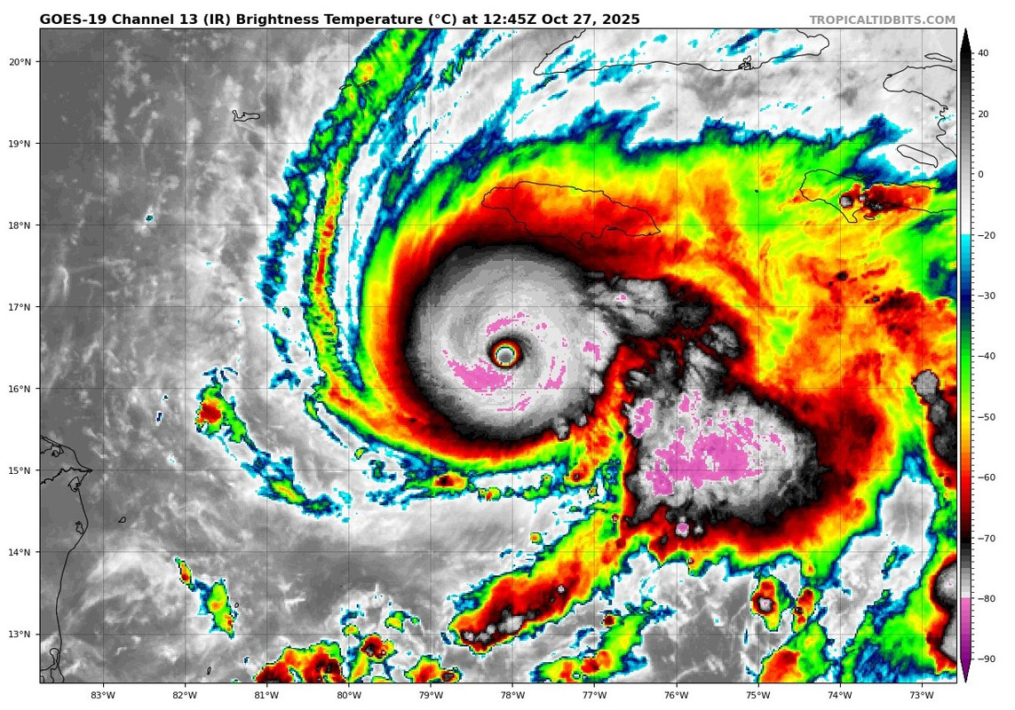
NATL: MELISSA - Aftermath - Discussion: Josh Morgerman video of Melissa is up

Moderator: S2k Moderators

Message
Author
jlauderdal
S2K Supporter
S2K Supporter
Posts: 7240
Joined: Wed May 19, 2004 5:46 am
Location: NE Fort Lauderdale
Contact:

Re: NATL: MELISSA - Hurricane - Discussion

#1381 Postby jlauderdal » Mon Oct 27, 2025 7:40 am

Sunnydays wrote:There are some great radio stations that stream live from Jamaica that will stream right up until they lose signal. I remember many of us listening during past hurricanes that passed over the island. This is my fav...but there are a few others.
https://edge105.com/listen-edge-105fm-live/

https://www.youtube.com/watch?v=U2vqjPCLt2M
1 likes   

User avatar
Teban54
Category 5
Category 5
Posts: 3787
Joined: Sat May 19, 2018 1:19 pm

Re: NATL: MELISSA - Hurricane - Discussion

#1382 Postby Teban54 » Mon Oct 27, 2025 7:42 am

Updating this list to include Melissa:

Teban54 wrote:Edit: This was written before the most recent Best Track update to 75 kts.
Edit 2 (10/27/2025): Added Melissa to the list now that it's a Cat 5.

Now that Melissa is officially a hurricane at 2pm ET, I got curious and looked at rates of intensification for Cat 5s, starting from the last time step they remained at 70 kts or lower. (For example, Erin 2025 spent 12 hours at 65 kt, which wasn't counted.)

I'm using "70 kt or lower" as the threshold for "minimum Cat 1", both because some storms jump from TS to this intensity (skipping 65 kt), and because low-end and high-end Cat 1s often display different organizational progress for further intensification.

TL;DR: A top-tier intensification rate (like Wilma, Milton and Erin) can bring Melissa to Cat 5 in the next 18-24 hours. But it's still very plausible to get a Cat 5, even without pinhole eyes, with a "normal" rate of 1.5-2 days. With almost 3 days before landfall, there's more than enough time.

Storms that intensified from 70- kt (low Cat 1) to 140+ kt (Cat 5) within 48 hours

  • Wilma 2005: 18 hours, 65 -> 150 kt (12z 10/18/05 to 06z 10/19/05)
  • Erin 2025: 18 hours 20 minutes, 65 -> 140 kt (21z 8/15/25 to 15:20z 8/16/25)
  • Felix 2007: 24 hours, 65 -> 150 kt (00z 9/2/07 to 00z 9/3/07)
  • Milton 2024: 24 hours, 70 -> 150 kt (18z 10/6/24 to 18z 10/7/24)
  • Matthew 2016: 24 hours, 70 -> 145 kt (00z 9/30/16 to 00z 10/1/16) - debated
  • Andrew 1992: 30 hours, 65 -> 145 kt (06z 8/22/92 to 12z 8/23/92)
  • Maria 2017: 30 hours, 65 -> 145 kt (18z 9/17/17 to 00z 9/19/17)
  • Edith 1971: 30 hours, 65 -> 140 kt (12z 9/8/71 to 18z 9/9/71)
  • Lee 2023: 30 hours, 70 -> 145 kt (00z 9/7/23 to 06z 9/8/23)
  • Rita 2005: 30 hours, 70 -> 145 kt (12z 9/20/05 to 18z 9/21/05)
  • "Labor Day" 1935: 36 hours, 65 -> 160 kt (12z 9/1/35 to 00z 9/3/35) - data issue, likely took much less time in reality
  • Camille 1969: 36 hours, 65 -> 150 kt (06z 8/15/69 to 18z 8/16/69) - with intermediate weakening
  • Humberto 2025: 36 hours, 65 -> 140 kt (09z 9/26/25 to 21z 9/27/25)
  • Melissa 2025: 39 hours, 65 -> 140 kt (18z 10/25/25 to 09z 10/27/25)
  • Janet 1955: 41 hours, 70 -> 140 kt (00z 9/26/55 to 17z 9/27/55)
  • "Tampico" 1933: 42 hours, 70 -> 140 kt (06z 9/19/33 to 00z 9/21/33)
  • Allen 1980: 42 hours, 70 -> 140 kt (06z 8/3/80 to 00z 8/5/80)
  • Hugo 1989: 42 hours, 70 -> 140 kt (00z 9/14/89 to 18z 9/15/89)
  • Dean 2007: 48 hours, 70 -> 145 kt (06z 8/16/07 to 06z 8/18/07)
  • Ian 2022: 48 hours, 70 -> 140 kt (12z 9/26/22 to 12z 9/28/22) - with intermediate weakening
  • Beryl 2024: 48 hours, 70 -> 140 kt (00z 6/30/24 to 00z 7/2/24) - with intermediate weakening
  • Anita 1977: 48 hours, 70 -> 140 kt (00z 8/31/77 to 00z 9/2/77)

Uses advisory times for 2025, and TCR for others (ignoring intermediate times unless in the TCR).
1 likes   

User avatar
Beef Stew
Category 2
Category 2
Posts: 642
Joined: Sat May 30, 2020 11:31 am
Location: South Florida

Re: NATL: MELISSA - Hurricane - Discussion

#1383 Postby Beef Stew » Mon Oct 27, 2025 7:46 am

Should be getting our center fix from NOAA any minute now. AF is headed back in as well from the SW.
0 likes   

User avatar
mrbagyo
Category 5
Category 5
Posts: 3962
Age: 33
Joined: Thu Apr 12, 2012 9:18 am
Location: 14.13N 120.98E
Contact:

Re: NATL: MELISSA - Hurricane - Discussion

#1384 Postby mrbagyo » Mon Oct 27, 2025 7:46 am

909.9 Extrap
154 - FL
4 likes   
The posts in this forum are NOT official forecast and should not be used as such. They are just the opinion of the poster and may or may not be backed by sound meteorological data. They are NOT endorsed by any professional institution or storm2k.org. For official information, please refer to RSMC, NHC and NWS products.

User avatar
Travorum
Category 2
Category 2
Posts: 623
Joined: Tue Sep 05, 2023 9:36 am
Location: Dunedin, FL

Re: NATL: MELISSA - Hurricane - Discussion

#1385 Postby Travorum » Mon Oct 27, 2025 7:46 am

909.9mb extrap for a deepening of 2.5mb at a rate of 2mb/hr since last pass (at least by extrap).
3 likes   

User avatar
mrbagyo
Category 5
Category 5
Posts: 3962
Age: 33
Joined: Thu Apr 12, 2012 9:18 am
Location: 14.13N 120.98E
Contact:

Re: NATL: MELISSA - Hurricane - Discussion

#1386 Postby mrbagyo » Mon Oct 27, 2025 7:51 am

Can it get lower than Ragasa's official 905 hpa? (though it has a unofficial 900.3hPa buoy reading and a still undisclosed reading from Calayan synop).
1 likes   
The posts in this forum are NOT official forecast and should not be used as such. They are just the opinion of the poster and may or may not be backed by sound meteorological data. They are NOT endorsed by any professional institution or storm2k.org. For official information, please refer to RSMC, NHC and NWS products.

User avatar
Beef Stew
Category 2
Category 2
Posts: 642
Joined: Sat May 30, 2020 11:31 am
Location: South Florida

Re: NATL: MELISSA - Hurricane - Discussion

#1387 Postby Beef Stew » Mon Oct 27, 2025 7:52 am

Interestingly enough, the FL winds in the NE are more or less the same as the NW. I guess she is just moving at a crawl, though.
1 likes   

User avatar
Beef Stew
Category 2
Category 2
Posts: 642
Joined: Sat May 30, 2020 11:31 am
Location: South Florida

Re: NATL: MELISSA - Hurricane - Discussion

#1388 Postby Beef Stew » Mon Oct 27, 2025 7:54 am

AF is about to make its SW to NE pass. Let’s see if we get any differences in the data.
0 likes   

User avatar
Teban54
Category 5
Category 5
Posts: 3787
Joined: Sat May 19, 2018 1:19 pm

Re: NATL: MELISSA - Hurricane - Discussion

#1389 Postby Teban54 » Mon Oct 27, 2025 7:54 am

Beef Stew wrote:AF is about to make its SW to NE pass. Let’s see if we get any differences in the data.

Two 153 kt FL readings in the SW quad. Extrap is 910.9 mb so far.
1 likes   

User avatar
GCANE
S2K Supporter
S2K Supporter
Posts: 12072
Joined: Mon Oct 22, 2007 8:03 am

Re: NATL: MELISSA - Hurricane - Discussion

#1390 Postby GCANE » Mon Oct 27, 2025 7:57 am

Hot tower shooting on the eastern periphery.
Hopefully a sign of a developing EWRC.
Watching recon's eye drops if the core is drying out.
1 likes   

User avatar
InfernoFlameCat
Category 5
Category 5
Posts: 2127
Age: 22
Joined: Mon Dec 14, 2020 10:52 am
Location: Buford, GA

Re: NATL: MELISSA - Hurricane - Discussion

#1391 Postby InfernoFlameCat » Mon Oct 27, 2025 8:00 am

GCANE wrote:Hot tower shooting on the eastern periphery.
Hopefully a sign of a developing EWRC.
Watching recon's eye drops if the core is drying out.

Idk, it has plenty of time to recover from an EWRC. I am not eager for one
2 likes   
I am by no means a professional. DO NOT look at my forecasts for official information or make decisions based on what I post.

Goal: to become a registered expert over tropical and subtropical cyclones.

User avatar
Blown Away
S2K Supporter
S2K Supporter
Posts: 10253
Joined: Wed May 26, 2004 6:17 am

Re: NATL: MELISSA - Hurricane - Discussion

#1392 Postby Blown Away » Mon Oct 27, 2025 8:03 am

Image
Melissa is supposed to be going N at 78.1W and continues moving WNW. This should move the landfall point farther W on Jamaica.
0 likes   
Hurricane Eye Experience: David 79, Irene 99, Frances 04, Jeanne 04, Wilma 05… Hurricane Brush Experience: Andrew 92, Erin 95, Floyd 99, Matthew 16, Irma 17, Ian 22, Nicole 22…

User avatar
Travorum
Category 2
Category 2
Posts: 623
Joined: Tue Sep 05, 2023 9:36 am
Location: Dunedin, FL

Re: NATL: MELISSA - Hurricane - Discussion

#1393 Postby Travorum » Mon Oct 27, 2025 8:06 am

Blown Away wrote: https://i.postimg.cc/sgPtRP8N/Melissa.jpg
Melissa is supposed to be going N at 78.1W and continues moving WNW. This should move the landfall point farther W on Jamaica.


I think not for certain? If it is further south when the trough grabs it, there's more time for it to be pulled east. So there's two opposing factors, the W movement and the lack of N movement.
Last edited by Travorum on Mon Oct 27, 2025 8:06 am, edited 1 time in total.
0 likes   

zzzh
Category 5
Category 5
Posts: 1027
Joined: Thu Sep 02, 2021 1:13 pm

Re: NATL: MELISSA - Hurricane - Discussion

#1394 Postby zzzh » Mon Oct 27, 2025 8:06 am

Image
This is one of the strongest dropsonde I've ever seen :eek:
9 likes   

ATDoel
Tropical Low
Tropical Low
Posts: 35
Joined: Thu Oct 23, 2025 8:02 am

Re: NATL: MELISSA - Hurricane - Discussion

#1395 Postby ATDoel » Mon Oct 27, 2025 8:07 am

Blown Away wrote: https://i.postimg.cc/sgPtRP8N/Melissa.jpg
Melissa is supposed to be going N at 78.1W and continues moving WNW. This should move the landfall point farther W on Jamaica.


If there's any silver lining, the odds of a direct hit on Kingston are going down every hour.
4 likes   

User avatar
kevin
Category 5
Category 5
Posts: 2878
Age: 27
Joined: Wed Aug 28, 2019 4:35 am

Re: NATL: MELISSA - Hurricane - Discussion

#1396 Postby kevin » Mon Oct 27, 2025 8:07 am

910.5 mb extrapolated pressure. Again 156 kt peak FL wind, which imo seems sufficient to support 145 kt.

Edit: removed surface pressure estimate using FL winds in the eye.
Last edited by kevin on Mon Oct 27, 2025 8:12 am, edited 1 time in total.
1 likes   

User avatar
Teban54
Category 5
Category 5
Posts: 3787
Joined: Sat May 19, 2018 1:19 pm

Re: NATL: MELISSA - Hurricane - Discussion

#1397 Postby Teban54 » Mon Oct 27, 2025 8:09 am

Teban54 wrote:
Beef Stew wrote:AF is about to make its SW to NE pass. Let’s see if we get any differences in the data.

Two 153 kt FL readings in the SW quad. Extrap is 910.9 mb so far.

AF measured two 156 kt FL readings in the NE quad, as well as a slightly lower extrap of 910.5 mb on the way out.

Do two identical readings imply anything differently from a single one?
0 likes   

zzzh
Category 5
Category 5
Posts: 1027
Joined: Thu Sep 02, 2021 1:13 pm

Re: NATL: MELISSA - Hurricane - Discussion

#1398 Postby zzzh » Mon Oct 27, 2025 8:09 am

kevin wrote:910.5 mb extrapolated with 18 kt nearby. Supports 909 - 910 mb. Again 156 kt peak FL wind, which imo seems sufficient to support 145 kt.

again you can't use fl wind for surface pressure adjustment
1 likes   

User avatar
kevin
Category 5
Category 5
Posts: 2878
Age: 27
Joined: Wed Aug 28, 2019 4:35 am

Re: NATL: MELISSA - Hurricane - Discussion

#1399 Postby kevin » Mon Oct 27, 2025 8:11 am

zzzh wrote:
kevin wrote:910.5 mb extrapolated with 18 kt nearby. Supports 909 - 910 mb. Again 156 kt peak FL wind, which imo seems sufficient to support 145 kt.

again you can't use fl wind for surface pressure adjustment


Oh yes you're right, guess I missed your previous message. Thanks for the correction :).
1 likes   

User avatar
Beef Stew
Category 2
Category 2
Posts: 642
Joined: Sat May 30, 2020 11:31 am
Location: South Florida

Re: NATL: MELISSA - Hurricane - Discussion

#1400 Postby Beef Stew » Mon Oct 27, 2025 8:13 am

I think 145 kts is definitely arguable at this point.
0 likes   


Return to “2025”

Who is online

Users browsing this forum: No registered users and 65 guests