Severe weather possible March 7 to 10?

U.S. & Caribbean Weather Discussions and Severe Weather Events

Moderator: S2k Moderators

Forum rules

The posts in this forum are NOT official forecast and should not be used as such. They are just the opinion of the poster and may or may not be backed by sound meteorological data. They are NOT endorsed by any professional institution or STORM2K.

Help Support Storm2K
Message
Author
badger70
S2K Supporter
S2K Supporter
Posts: 242
Joined: Sun Mar 12, 2006 9:22 pm
Location: KSTL

Re: Severe weather possible March 7 to 10?

#141 Postby badger70 » Mon Mar 09, 2009 7:28 pm

RL3AO wrote:Heres a link that shows the streams of different chasers on a map with radar and the works.

http://tornadovideos.net/full-screen-chaser-video.php


A similar site is at http://www.spotternetwork.org/google.php
0 likes   

RL3AO
Moderator-Pro Met
Moderator-Pro Met
Posts: 16308
Joined: Thu Jun 14, 2007 10:03 pm
Location: NC

#142 Postby RL3AO » Mon Mar 09, 2009 7:50 pm

Image

MESOSCALE DISCUSSION 0220
NWS STORM PREDICTION CENTER NORMAN OK
0736 PM CDT MON MAR 09 2009

AREAS AFFECTED...PARTS OF THE TX BIG COUNTRY

CONCERNING...SEVERE POTENTIAL...WATCH UNLIKELY

VALID 100036Z - 100130Z

AN ISOLD LARGE HAIL/WIND THREAT MAY EVOLVE IN THE NEXT HR OR TWO
OVER PARTS OF THE TX BIG COUNTRY REGION. A WW DOES NOT APPEAR TO BE
WARRANTED ATTM DUE TO EXPECTED RELATIVELY ISOLD CONVECTIVE COVERAGE
ALONG WITH ANTICIPATED MARGINAL MAGNITUDE OF SEVERE THREAT.

RECENT RADAR MOSAIC SHOWS INTENSIFYING CONVECTION ALONG SW-NE
ORIENTED LOW LEVEL CONFLUENCE ZONE/DRYLINE FROM UPTON TO HOWARD
COUNTY TX. STRONG UNIDIRECTIONAL SHEAR PROFILE /00Z MAF RAOB OF 70
KTS 0-6 KM SHEAR/ NEARLY PARALLEL TO INITIATING BOUNDARY WILL SERVE
TO PROMOTE UPSCALE GROWTH INTO A LOOSE BAND OF CELL MERGING-LINEAR
CONVECTION. DESPITE MODEST POTENTIAL INSTABILITY /MODIFIED FORECAST
SOUNDING 1000 J/KG MUCAPE/...STORMS MAY POSE AN ISOLD LARGE
HAIL/DMGG WIND THREAT WITH THE SRN STRONGER CORE/S AS TSTMS ORGANIZE
WITH TIME.

..SMITH.. 03/10/2009


ATTN...WFO...OUN...SJT...LUB...MAF...
0 likes   

User avatar
srainhoutx
S2K Supporter
S2K Supporter
Posts: 6919
Age: 67
Joined: Sun Jan 14, 2007 11:34 am
Location: Haywood County, NC
Contact:

Re: Severe weather possible March 7 to 10?

#143 Postby srainhoutx » Mon Mar 09, 2009 8:11 pm

Tomorrow looks like the day IMHO. Stay safe folks.
0 likes   

Ed Mahmoud

Re: Severe weather possible March 7 to 10?

#144 Postby Ed Mahmoud » Tue Mar 10, 2009 2:18 pm

Pockets of sun ahead of the front in the SLIGHT RISK area. NAM seems to suggest all/most storms are right on or behind the front, which would minimize tornado risk, although not completely eliminate hail and wind threat.

Image

Mid 70s ahead of the front.

RUC suggests pretty limited instability (AOB 500 J/Kg), but seems to show some activity developing on or just ahead of the front in MO and AR.
Image


RUC soundings show pretty good helicity, but limited instability.


A couple of days ago, it looked like today would be an active severe weather day, and it isn't looking super-active now.
0 likes   

User avatar
Bunkertor
Category 5
Category 5
Posts: 3397
Joined: Tue May 09, 2006 3:48 pm

#145 Postby Bunkertor » Tue Mar 10, 2009 3:07 pm

Wow, they are late with the update. Seems they are not sure...+ next update is at 1AM
0 likes   

Ed Mahmoud

Re:

#146 Postby Ed Mahmoud » Tue Mar 10, 2009 3:17 pm

Bunkertor wrote:Wow, they are late with the update. Seems they are not sure...+ next update is at 1AM


They slightly extended the SLIGHT RISK area to catch most of the DFW area (earlier outlooks just grazed NE corner of NWS FWD CWA), but otherwise, no huge changes.
0 likes   

User avatar
srainhoutx
S2K Supporter
S2K Supporter
Posts: 6919
Age: 67
Joined: Sun Jan 14, 2007 11:34 am
Location: Haywood County, NC
Contact:

Re: Severe weather possible March 7 to 10?

#147 Postby srainhoutx » Tue Mar 10, 2009 3:25 pm

Image

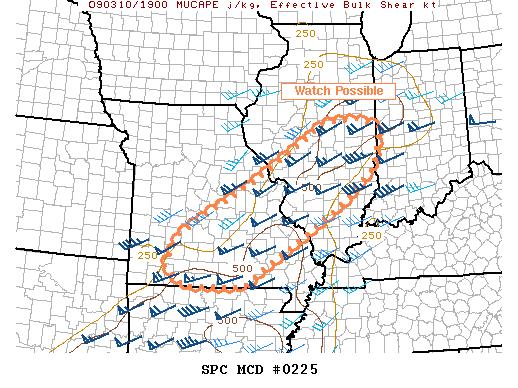
MESOSCALE DISCUSSION 0225
NWS STORM PREDICTION CENTER NORMAN OK
0315 PM CDT TUE MAR 10 2009

AREAS AFFECTED...PORTIONS OF ERN/SRN MO ACROSS CENTRAL AND PORTIONS
OF SRN IL

CONCERNING...SEVERE POTENTIAL...WATCH POSSIBLE

VALID 102015Z - 102215Z

SUFFICIENT HEATING HAS OCCURRED AHEAD OF COLD FRONT THAT IS
DIAGONALLY NE/SW ACROSS MO FOR SURFACE BASED CONVECTION TO DEVELOP.
THE PRIMARY LIMITING PARAMETER FOR SEVERE IS THE INSTABILITY. WITH
MLCAPES GENERALLY LESS THAN 500 J/KG...EVEN WITH SURFACE TEMPS INTO
THE MID 70S F AND DEWPOINTS MID/UPR 50S...UPDRAFTS WILL BE SLOW TO
INTENSIFY. HOWEVER A VERY STRONG WIND PROFILE IS TRANSLATING ACROSS
THE MID MS VALLEY AS AN INTENSE S/WV AND 100 KT 500 MB WIND MAX
TRACKS FROM IA TO WI THIS EVENING.

THERE IS STILL SOME UNCERTAINTY WITH REGARDS TO EXTENT OF ANY SEVERE
THREAT SUFFICIENT TO WARRANT A WATCH...BUT GIVEN THE VERY IMPRESSIVE
KINEMATIC SUPPORT WITH SFC-6KM SHEAR OF 60KT...POTENTIAL EXISTS FOR
NOT ONLY LOW TOPPED THUNDERSTORMS TO FORM INTO SHORT LINE
SEGMENTS/BOWS WHICH WOULD ENHANCE A WIND DAMAGE CONCERN BUT ALSO
DEVELOP AT LEAST LOW LEVEL ROTATION FOR AN ISOLATED TORNADO THREAT.

THE CURRENT LOW TOPPED CONVECTION DEVELOPING VICINITY COU SWWD
TOWARD SGF SHOULD INCREASE IN COVERAGE AND GRADUALLY INTENSITY
SPREADING EWD ACROSS ERN/SRN MO INTO CENTRAL IL REMAINDER OF THE
AFTERNOON.

..HALES.. 03/10/2009


ATTN...WFO...IND...PAH...ILX...LSX...SGF...
0 likes   


Return to “USA & Caribbean Weather”

Who is online

Users browsing this forum: Cpv17, houstonkid75, Storm861, txtwister78, WeatherNewbie, WeatherP1 and 68 guests