NW Carribean / Southern GOM / BOC (Is invest 96L)
Moderator: S2k Moderators
Forum rules

The posts in this forum are NOT official forecasts and should not be used as such. They are just the opinion of the poster and may or may not be backed by sound meteorological data. They are NOT endorsed by any professional institution or STORM2K. For official information, please refer to products from the National Hurricane Center and National Weather Service.
-
Rgv20

- S2K Supporter

- Posts: 2466
- Age: 39
- Joined: Wed Jan 05, 2011 5:42 pm
- Location: Edinburg/McAllen Tx
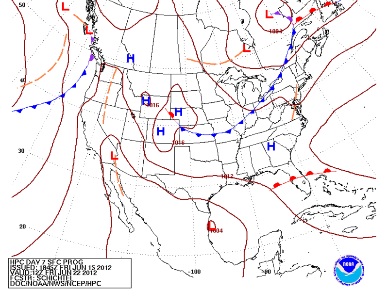
HPC Forecast valid for Friday morning.
0 likes
The following post is NOT an official forecast and should not be used as such. It is just the opinion of the poster and may or may not be backed by sound meteorological data. It is NOT endorsed by any professional institution including storm2k.org For Official Information please refer to the NHC and NWS products.
-
thundercam96

- Tropical Storm

- Posts: 129
- Joined: Thu Aug 18, 2011 3:01 pm
- Location: Boston, MA
Re: NW Carribean / Southern GOM / BOC
PTrackerLA wrote:Looks like this run is tracking to the northern gulf coast.
If That High Pressure Is On The Eastern Seaboard It Will Prevent A Florida Landfall?
0 likes
Fay '08 / Mathew 16'
Personal Forecast Disclaimer: I am not a certified meteorologist, therefore, what is posted on this forum under my header should not be treated as an official forecast. Please refer to the NWS/NHC products for forecast information.
Personal Forecast Disclaimer: I am not a certified meteorologist, therefore, what is posted on this forum under my header should not be treated as an official forecast. Please refer to the NWS/NHC products for forecast information.
-
USTropics
- Professional-Met

- Posts: 2737
- Joined: Sun Aug 12, 2007 3:45 am
- Location: Florida State University
Re: NW Carribean / Southern GOM / BOC
thundercam96 wrote:PTrackerLA wrote:Looks like this run is tracking to the northern gulf coast
If That High Pressure Is On The Eastern Seaboard It Will Prevent A Florida Landfall?
That is correct. While the latest GFS run has backed off on the strength of the ridging, and to a degree why there is more of a northern track (coupled with the location of initialization), the ridging has been consistent in the previous model runs. The exact location of formation and how strong the ridge will be ultimately determines the track, but at this time it appears the system will be isolated to the northern or western portions of the GOM/BOC and not a threat to Florida.
0 likes
-
HouTXmetro

- Category 5

- Posts: 3949
- Joined: Sun Jun 13, 2004 6:00 pm
- Location: District of Columbia, USA
Re: NW Carribean / Southern GOM / BOC
Did GFS have a landfall? If so, where?
0 likes
[Disclaimer: My Amateur Opinion, please defer to your local authorities or the NHC for Guidance.]
Re: NW Carribean / Southern GOM / BOC
Carlotta will transfer energy up US Mid section - causing explosive storms in mid west
Same pattern as last 2 years. Shredded storms -in/around Gulf?
http://www.ssec.wisc.edu/data/geo/index ... thod=flash
Same pattern as last 2 years. Shredded storms -in/around Gulf?
http://www.ssec.wisc.edu/data/geo/index ... thod=flash
0 likes
-
SETXWXLADY
- Tropical Storm
- Posts: 216
- Joined: Wed May 20, 2009 3:26 pm
- Location: SE TX Orange County
Re: NW Carribean / Southern GOM / BOC
HouTXmetro wrote:Did GFS have a landfall? If so, where?

0 likes
-
Rgv20
- S2K Supporter
- Posts: 2466
- Age: 39
- Joined: Wed Jan 05, 2011 5:42 pm
- Location: Edinburg/McAllen Tx
18zGFS Ensembles do not agree with the operational run of the 18zGFS.....The 0z run is going to be interesting.
18zGFS Ensembles Forecast valid for Thursday night.
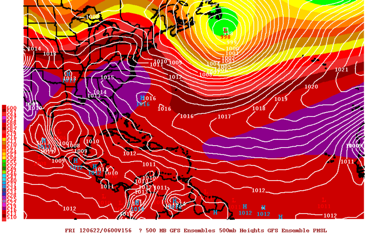
18zGFS Ensembles Forecast valid for Thursday night.
0 likes
The following post is NOT an official forecast and should not be used as such. It is just the opinion of the poster and may or may not be backed by sound meteorological data. It is NOT endorsed by any professional institution including storm2k.org For Official Information please refer to the NHC and NWS products.

Re: NW Carribean / Southern GOM / BOC
the 0z GFS doesnt really show anything other than a broad area of low pressure around BOC at 186hr
http://mag.ncep.noaa.gov/NCOMAGWEB/appc ... mageSize=M
http://mag.ncep.noaa.gov/NCOMAGWEB/appc ... mageSize=M
0 likes
Re: NW Carribean / Southern GOM / BOC
the 18Z NOGAPS was interesting takes our BOC friend further up the Texas coast....
https://www.fnmoc.navy.mil/wxmap_cgi/cg ... t=Tropical
https://www.fnmoc.navy.mil/wxmap_cgi/cg ... t=Tropical
0 likes
Re: NW Carribean / Southern GOM / BOC
OZ NOGAPS on drugs again....brings the carib upi thru the channel and into Texas...then splits into 2 entities...
https://www.fnmoc.navy.mil/wxmap_cgi/cg ... t=Tropical
https://www.fnmoc.navy.mil/wxmap_cgi/cg ... t=Tropical
0 likes
-
South Texas Storms

- Professional-Met
- Posts: 4256
- Joined: Thu Jun 24, 2010 12:28 am
- Location: Houston, TX
Re: NW Carribean / Southern GOM / BOC
ROCK wrote:OZ NOGAPS on drugs again....brings the carib upi thru the channel and into Texas...then splits into 2 entities...
https://www.fnmoc.navy.mil/wxmap_cgi/cg ... t=Tropical
Rock it looks like the models don't have a clue right now. Hopefully King Euro will help us out a bit tonight.
0 likes
-
Rgv20
- S2K Supporter
- Posts: 2466
- Age: 39
- Joined: Wed Jan 05, 2011 5:42 pm
- Location: Edinburg/McAllen Tx
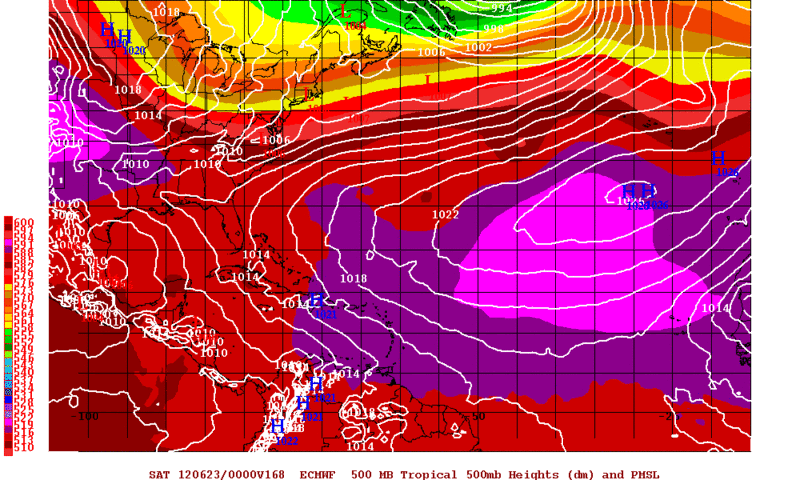
0zGFS does develop a weak low in the Western GOM on Friday and bring toward the NE Mexican Coast......Of note the 0zGFS Ensembles Mean are south of the operational GFS. The reason the Euro has not develop the disturbance is that it keeps it really close to the Mexican coast and that is why it does not show more development. STS the Euro solution has a lot of Rain from about SA southward and 4+ inches for the RGV 
0 likes
The following post is NOT an official forecast and should not be used as such. It is just the opinion of the poster and may or may not be backed by sound meteorological data. It is NOT endorsed by any professional institution including storm2k.org For Official Information please refer to the NHC and NWS products.
Re: NW Carribean / Southern GOM / BOC
South Texas Storms wrote:ROCK wrote:OZ NOGAPS on drugs again....brings the carib upi thru the channel and into Texas...then splits into 2 entities...
https://www.fnmoc.navy.mil/wxmap_cgi/cg ... t=Tropical
Rock it looks like the models don't have a clue right now. Hopefully King Euro will help us out a bit tonight.
yeah hope so.....starts in 3 minutes....
0 likes
-
South Texas Storms
- Professional-Met
- Posts: 4256
- Joined: Thu Jun 24, 2010 12:28 am
- Location: Houston, TX
Re: NW Carribean / Southern GOM / BOC
Yeah the 12z Euro was great for us Rgv. The 0z GFS made me sad though (only had .50 inch for SA). Hopefully the 0z Euro will keep us wet 
0 likes
-
Rgv20
- S2K Supporter
- Posts: 2466
- Age: 39
- Joined: Wed Jan 05, 2011 5:42 pm
- Location: Edinburg/McAllen Tx
Looks like the 0zECMWF tries to get a low going by Friday Evening but its to close to the Mexican Coast to get going.
0 likes
The following post is NOT an official forecast and should not be used as such. It is just the opinion of the poster and may or may not be backed by sound meteorological data. It is NOT endorsed by any professional institution including storm2k.org For Official Information please refer to the NHC and NWS products.
-
South Texas Storms
- Professional-Met
- Posts: 4256
- Joined: Thu Jun 24, 2010 12:28 am
- Location: Houston, TX
Re: NW Carribean / Southern GOM / BOC
Rgv if the 0z Euro qpf forecast verifies, I will be heartbroken. Has 2 inches about 50 miles south of SA and only .25 inch for me. You get hit pretty good though!
0 likes
-
Hurricane Alexis

- Category 2

- Posts: 683
- Age: 29
- Joined: Thu Jun 14, 2012 7:59 pm
- Location: Miami,Florida
Re: NW Carribean / Southern GOM / BOC
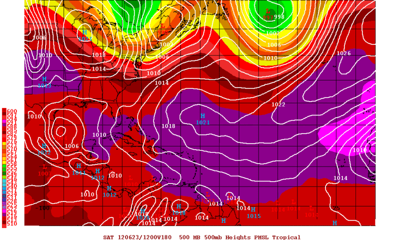
06z GFS continues to show an area of low pressure in the BOC in 129hr and it helping to bring lots of deep moisture to south florida 
http://mag.ncep.noaa.gov/NCOMAGWEB/appc ... tImage=yes
http://mag.ncep.noaa.gov/NCOMAGWEB/appc ... tImage=yes
0 likes
-
cycloneye

- Admin

- Posts: 149275
- Age: 69
- Joined: Thu Oct 10, 2002 10:54 am
- Location: San Juan, Puerto Rico
Re: NW Carribean / Southern GOM / BOC
This mornings long range discussions from NWS Coupus Christi and Houston/Galveston.
Corpus Christi
.LONG TERM (SUNDAY NIGHT THROUGH FRIDAY)...PRECIP CHANCES CONTINUE
TO BE THE MAIN FORECAST CHALLENGE DURING THE EXTENDED PERIOD. HEIGHT
FIELDS PROG TO LOWER FIRST HALF OF THE WORK WEEK AS MID LEVEL LOW
RETROGRADES ACROSS W GULF AND EVENTUALLY MOVES OVER S TX. DEEP LAYER
MOISTURE WILL ALSO INCREASE WITH PWATS PROG TO APPROACH 1.8 INCHES
ACROSS EASTERN HALF OF CWA. GIVEN THE ABOVE...ISOLATED CONVECTION IS
EXPECTED MONDAY WITH BETTER CHANCES ON TUES AND WED /ESPECIALLY
ACROSS MARINE AREAS AND EASTERN HALF OF CWA/. FORECAST CONFIDENCE
THEN LOWERS FOR LATTER HALF OF THE WORK WEEK. GUIDANCE CONTINUES TO
DIFFER ON HANDLING OF ANY TROPICAL DISTURBANCE THAT MAY EMERGE FROM
BAY OF CAMPECHE. GFS CONTINUES TO TIGHTEN UP A SURFACE VORTEX IN THE
BAY AND MOVE IT NORTHWARD TOWARDS THE WEAKNESS IN THE H5 RIDGE...BUT
CONTINUES TO VARY RUN TO RUN WITH POSITIONING AND DEVELOPMENT OF
SYSTEM. FOR NOW HAVE SKEWED LATTER HALF OF FORECAST CLOSER TO ECMWF
WHICH HAS BEEN MORE CONSISTENT FROM RUN TO RUN AND KEEPS MORE OF A
BROAD AREA OF LOW PRESSURE IN THE SW GULF. AT THIS TIME AM EXPECTING
DEEP TROPICAL MOISTURE TO INFILTRATE S TX SECOND HALF OF NEXT WEEK
WITH DAILY /AND NIGHTLY/ CHANCES OF SHOWERS AND THUNDERSTORMS
OCCURRING. SYSTEM CONTINUES TO BEAR WATCHING AS POTENTIAL FOR HEAVY
RAIN EVENT MAY SET UP IF ECMWF VERIFIES...WHILE DRY AND HOT
CONDITIONS MAY PREVAIL IF SYSTEM BECOMES MORE ORGANIZED AND STAYS TO
OUR SOUTH OR EAST.
Houston/Galveston
BIG QUESTION IN LONG RANGE REMAINS POSSIBLE (LOOKING MORE LIKELY
EACH DAY THOUGH) TROPICAL DEVELOPMENT IN THE BAY OF CAMPECHE LATE
ON THURSDAY. GFS AND ECMWF DISAGREE AS ONE WOULD EXPECT AT SUCH
LONG RANGE ON DETAILS. LARGE CIRCULATION AROUND THIS FEATURE IN
BOTH GFS/ECM BRINGS BANDS OF PRECIP NORTHWEST INTO SOUTHEAST TX
COASTAL WATERS (GFS MOSTLY) AND BARELY INLAND (ECM). FOR NOW
PRUDENT PATH SEEMS TO BE A BLEND OF MODELS FOR PCPN CHANCES AND
WEATHER WITH A BIT OF A NOD TOWARD THE ECM WHICH SEEMS TO HAVE A
TAD MORE MODEL TO MODEL RUN CONSISTENCY SO FAR.
0 likes
Visit the Caribbean-Central America Weather Thread where you can find at first post web cams,radars
and observations from Caribbean basin members Click Here
and observations from Caribbean basin members Click Here
-
Aric Dunn
- Category 5
- Posts: 21238
- Age: 43
- Joined: Sun Sep 19, 2004 9:58 pm
- Location: Ready for the Chase.
- Contact:
w a t c h the south west c a rr i b e a n today.
0 likes
Note: If I make a post that is brief. Please refer back to previous posts for the analysis or reasoning. I do not re-write/qoute what my initial post said each time.
If there is nothing before... then just ask
Space & Atmospheric Physicist, Embry-Riddle Aeronautical University,
I believe the sky is falling...
If there is nothing before... then just ask
Space & Atmospheric Physicist, Embry-Riddle Aeronautical University,
I believe the sky is falling...
-
cycloneye
- Admin
- Posts: 149275
- Age: 69
- Joined: Thu Oct 10, 2002 10:54 am
- Location: San Juan, Puerto Rico
Re:
Aric Dunn wrote:w a t c h the south west c a rr i b e a n today.
11N-78W.
http://www.ssd.noaa.gov/goes/east/carb/flash-vis.html
0 likes
Visit the Caribbean-Central America Weather Thread where you can find at first post web cams,radars
and observations from Caribbean basin members Click Here
and observations from Caribbean basin members Click Here
Who is online
Users browsing this forum: No registered users and 187 guests