ATL: HERMINE - Post-Tropical - Discussion

Moderator: S2k Moderators

Message
Author
User avatar
Hammy
Category 5
Category 5
Posts: 5849
Age: 41
Joined: Fri May 25, 2012 5:25 pm
Contact:

Re: ATL: INVEST 99L - Discussion

#141 Postby Hammy » Sat Aug 20, 2016 12:34 am

SeGaBob wrote:I think some are writing it off way to early... I get tired of hearing king euro over and over too. Just wait and see before jumping to conclusions. 8-)


It was right about Erika last year and the GFS has known issues with overblowing storms this time of year. The simple fact of the matter here is the Euro has been more consistent in not developing this, while the GFS has been all over the place.
2 likes   
The above post is not official and should not be used as such. It is the opinion of the poster and may or may not be backed by sound meteorological data. It is not endorsed by any professional institution or storm2k.org. For official information, please refer to the NHC and NWS products.

User avatar
Kingarabian
S2K Supporter
S2K Supporter
Posts: 15979
Joined: Sat Aug 08, 2009 3:06 am
Location: Honolulu, Hawaii

Re: ATL: INVEST 99L - Discussion

#142 Postby Kingarabian » Sat Aug 20, 2016 12:40 am

Hammy wrote:
SeGaBob wrote:I think some are writing it off way to early... I get tired of hearing king euro over and over too. Just wait and see before jumping to conclusions. 8-)


It was right about Erika last year and the GFS has known issues with overblowing storms this time of year. The simple fact of the matter here is the Euro has been more consistent in not developing this, while the GFS has been all over the place.


Exactly this. The Euro at least needs to show something.
0 likes   
RIP Kobe Bryant

SeGaBob

Re: ATL: INVEST 99L - Discussion

#143 Postby SeGaBob » Sat Aug 20, 2016 12:45 am

Well let's not forget when the EURO had Debby (2012) in the gulf that was supposed to hit Texas but GFS showed Florida and that's where it went. I have no more to say because this will turn into another model war.
1 likes   

User avatar
chaser1
S2K Supporter
S2K Supporter
Posts: 5464
Age: 64
Joined: Sat Oct 15, 2005 5:59 pm
Location: Longwood, Fl

Re: ATL: INVEST 99L - Discussion

#144 Postby chaser1 » Sat Aug 20, 2016 1:02 am

Lets assume that 99L develops more or less as the GFS suggests it will. Now,"if" the EURO waits until Sunday and then forecasts 99L to form in a 48-72 hr. time frame - and it then does.....
What would be your take on the modeling then? Reason i'm asking is that some will praise the model Gods that the EURO predicted 99L to develop, well sure eventually. Here's another bold prediction: I'm going to go to sleep in about 10 minutes. If I'm right, that doesnt suddenly make me Houdini does it? lol. On the other hand, "if" 99L were to develop more or less in line with recent GFS forecasts, than I'd say that the two models ended up more or less in agreement. The only difference being that one of the models began to forecast development, while the other forecast model was "a little late to the party".
0 likes   
Andy D

(For official information, please refer to the NHC and NWS products.)

USTropics
Professional-Met
Professional-Met
Posts: 2647
Joined: Sun Aug 12, 2007 3:45 am
Location: Florida State University

Re: ATL: INVEST 99L - Discussion

#145 Postby USTropics » Sat Aug 20, 2016 1:21 am

ZCZC MIATWOAT ALL
TTAA00 KNHC DDHHMM

TROPICAL WEATHER OUTLOOK
NWS NATIONAL HURRICANE CENTER MIAMI FL
200 AM EDT SAT AUG 20 2016

For the North Atlantic...Caribbean Sea and the Gulf of Mexico:

The National Hurricane Center is issuing advisories on Tropical
Storm Fiona, located over the central tropical Atlantic.

1. A broad area of low pressure, associated with a tropical wave, is
located about 700 miles west-southwest of the Cabo Verde Islands.
This disturbance is producing a large but disorganized area of
showers and thunderstorms, and any development of this system during
the next couple of days should be slow to occur due to its proximity
to dry air. Environmental conditions are forecast to be more
conducive for development after that time, and a tropical depression
could form by the middle of next week while the system moves
westward at 15 to 20 mph across the tropical Atlantic Ocean and into
the eastern Caribbean Sea.
* Formation chance through 48 hours...low...10 percent
* Formation chance through 5 days...medium...50 percent

2. A tropical wave inland over western Africa is producing a large area
of showers and thunderstorms. This system is expected to move over
water by late Saturday night, and environmental conditions appear
conducive for gradual development next week while it moves generally
west-northwestward over the eastern tropical Atlantic Ocean.
* Formation chance through 48 hours...low...10 percent
* Formation chance through 5 days...medium...40 percent

Forecaster Blake
0 likes   

User avatar
Hammy
Category 5
Category 5
Posts: 5849
Age: 41
Joined: Fri May 25, 2012 5:25 pm
Contact:

Re: ATL: INVEST 99L - Discussion

#146 Postby Hammy » Sat Aug 20, 2016 1:58 am

SeGaBob wrote:Well let's not forget when the EURO had Debby (2012) in the gulf that was supposed to hit Texas but GFS showed Florida and that's where it went. I have no more to say because this will turn into another model war.


Euro has an iffy track record on storm track (no pun intended) for systems that are already developed--it's even been pointed out on here numerous times this season alone. However the model tends to do better more often than not than the GFS, and when the GFS is showing development within the 72-96 hour time frame and the Euro isn't, more often than not nothing forms. In just the last four years alone I've seen far too many instances where the GFS will show development with the Euro not doing so, and then when it comes to within 48 hours of "development" the GFS gradually backs off and we end up having nothing form.

I stand by my forecast of no hurricanes for the remainder of August, and I'm confident enough that I've placed money on that. :D
1 likes   
The above post is not official and should not be used as such. It is the opinion of the poster and may or may not be backed by sound meteorological data. It is not endorsed by any professional institution or storm2k.org. For official information, please refer to the NHC and NWS products.

User avatar
TheDreamTraveler
Category 2
Category 2
Posts: 641
Joined: Sun Aug 22, 2010 3:10 am
Location: PA

Re: ATL: INVEST 99L - Discussion

#147 Postby TheDreamTraveler » Sat Aug 20, 2016 1:58 am

Hammy wrote:
SeGaBob wrote:I think some are writing it off way to early... I get tired of hearing king euro over and over too. Just wait and see before jumping to conclusions. 8-)


It was right about Erika last year and the GFS has known issues with overblowing storms this time of year. The simple fact of the matter here is the Euro has been more consistent in not developing this, while the GFS has been all over the place.


The Atlantic was an entirely different environment last year due especially to the raging super El Nino. A lot of storms suffered the same fate. So I wouldn't use just one storm as an example. Right now ENSO conditions are pretty much neutral and should be through the rest of the season. Hence why the amount of storms for the season increased from CSU, NHC and others.

Once the storm actually develops (if it does), then the models will have a much better grasp on the environment, strength and track. Any waves that get closer to the CONUS are going to have a much easier time developing due to the high heat content just to name one factor.
0 likes   

User avatar
Hammy
Category 5
Category 5
Posts: 5849
Age: 41
Joined: Fri May 25, 2012 5:25 pm
Contact:

Re: ATL: INVEST 99L - Discussion

#148 Postby Hammy » Sat Aug 20, 2016 2:12 am

TheDreamTraveler wrote:Once the storm actually develops (if it does), then the models will have a much better grasp on the environment, strength and track. Any waves that get closer to the CONUS are going to have a much easier time developing due to the high heat content just to name one factor.


This is the key--will it develop in the first place, and the models are split enough to give me strong doubt--the models seem to handle things completely different between when they're a wave or an actual classified system.
0 likes   
The above post is not official and should not be used as such. It is the opinion of the poster and may or may not be backed by sound meteorological data. It is not endorsed by any professional institution or storm2k.org. For official information, please refer to the NHC and NWS products.

Frank2
Category 5
Category 5
Posts: 4061
Joined: Mon Jul 25, 2005 12:47 pm

Re: ATL: INVEST 99L - Discussion

#149 Postby Frank2 » Sat Aug 20, 2016 3:54 am

I know this is for Fiona but shows the hostile environment right now also for 99L.

Just my gut feeling, but it's probably going to be a early Fall (already the progression of mid-latitude fronts is increasing)...

http://www.nhc.noaa.gov/text/refresh/MI ... 0842.shtml?
Last edited by Frank2 on Sat Aug 20, 2016 6:36 am, edited 1 time in total.
0 likes   

User avatar
Nimbus
Category 5
Category 5
Posts: 5300
Joined: Mon Jul 19, 2004 10:54 am

Re: ATL: INVEST 99L - Discussion

#150 Postby Nimbus » Sat Aug 20, 2016 6:32 am

The ridging has been building west from Bermuda and almost reached Fiona which might ease some of the southerly shear that has been undercutting its circulation.

99L has remained a slow moving wave reliant on moisture from the ITCZ. As this system approaches -40 W without gaining latitude its no surprise the models have been shifting their tracks left. 06 Z GFS now into the gulf of Mexico. Hoping the environment remains hostile but if it does make it to storm status it would be less vulnerable to shear.
0 likes   

User avatar
Gustywind
Category 5
Category 5
Posts: 12334
Joined: Mon Sep 03, 2007 7:29 am
Location: Baie-Mahault, GUADELOUPE

Re: ATL: INVEST 99L - Discussion

#151 Postby Gustywind » Sat Aug 20, 2016 6:38 am

Stays at 10%-50%

TROPICAL WEATHER OUTLOOK
NWS NATIONAL HURRICANE CENTER MIAMI FL
800 AM EDT SAT AUG 20 2016

For the North Atlantic...Caribbean Sea and the Gulf of Mexico:

A broad area of low pressure, associated with a tropical wave, is
located about 750 miles west-southwest of the Cabo Verde Islands.
This system continues to produce disorganized showers and
thunderstorms, and any development should be slow to occur due to
its large size and proximity to dry air. Environmental conditions
are forecast to be more conducive for development beyond a couple
of days, and a tropical depression could form by the middle of next
week while the system moves westward at 15 to 20 mph across the
tropical Atlantic Ocean and into the eastern Caribbean Sea.
* Formation chance through 48 hours...low...10 percent
* Formation chance through 5 days...medium...50 percent


$$
Forecaster Cangialosi
0 likes   

User avatar
NDG
S2K Supporter
S2K Supporter
Posts: 15446
Joined: Sun Jul 09, 2006 10:14 pm
Location: Orlando, FL

Re: ATL: INVEST 99L - Discussion

#152 Postby NDG » Sat Aug 20, 2016 6:52 am

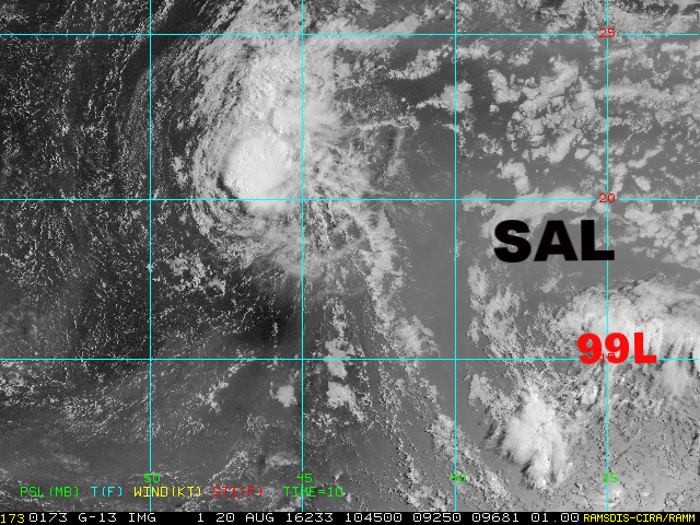
:uarrow: As mentioned by the latest TWO, clearly on visible satellite you can see the Dust/SAL that 99L has to battle in the short term, so I agree of 10% development for the next 2 days, any development will not be until it gets closer to the Windward/Leeward Islands.

Image
0 likes   

User avatar
Gustywind
Category 5
Category 5
Posts: 12334
Joined: Mon Sep 03, 2007 7:29 am
Location: Baie-Mahault, GUADELOUPE

Re: ATL: INVEST 99L - Discussion

#153 Postby Gustywind » Sat Aug 20, 2016 6:53 am

000
AXNT20 KNHC 201001
TWDAT

Tropical Weather Discussion
NWS National Hurricane Center Miami FL
601 AM EDT SAT AUG 20 2016

Tropical wave is in the central Atlantic extending from 05N35W to a
1009 mb low near 11N35W to 16N33W, moving W at 15 kt within the
last 24 hours. Intrusion of Saharan dry air and dust to the wave
environment continue to limit the convection to scattered showers
and isolated tstms from 05N-16N between 30W and 40W. Any
development of this system during the next couple of days should
be slow to occur due to its proximity to dry air. Environmental
conditions are forecast to be more conducive for development after
that time, and a tropical depression could form by the middle of
next week while the system moves westward across the tropical
Atlantic Ocean and into the eastern Caribbean Sea.
0 likes   

User avatar
cycloneye
Admin
Admin
Posts: 145271
Age: 68
Joined: Thu Oct 10, 2002 10:54 am
Location: San Juan, Puerto Rico

Re: ATL: INVEST 99L - Discussion

#154 Postby cycloneye » Sat Aug 20, 2016 7:25 am

12z Best Track

AL, 99, 2016082012, , BEST, 0, 112N, 354W, 25, 1009, LO
0 likes   
Visit the Caribbean-Central America Weather Thread where you can find at first post web cams,radars
and observations from Caribbean basin members Click Here

User avatar
gatorcane
S2K Supporter
S2K Supporter
Posts: 23691
Age: 47
Joined: Sun Mar 13, 2005 3:54 pm
Location: Boca Raton, FL

Re: ATL: INVEST 99L - Discussion

#155 Postby gatorcane » Sat Aug 20, 2016 7:43 am

NHC outlook seems to suggest they are leaning against a Caribbean cruiser looking at the outlook graphic/shading
0 likes   

tolakram
Admin
Admin
Posts: 20009
Age: 62
Joined: Sun Aug 27, 2006 8:23 pm
Location: Florence, KY (name is Mark)

Re: ATL: INVEST 99L - Discussion

#156 Postby tolakram » Sat Aug 20, 2016 8:23 am

Hammy wrote:
SeGaBob wrote:Well let's not forget when the EURO had Debby (2012) in the gulf that was supposed to hit Texas but GFS showed Florida and that's where it went. I have no more to say because this will turn into another model war.


Euro has an iffy track record on storm track (no pun intended) for systems that are already developed--it's even been pointed out on here numerous times this season alone. However the model tends to do better more often than not than the GFS, and when the GFS is showing development within the 72-96 hour time frame and the Euro isn't, more often than not nothing forms. In just the last four years alone I've seen far too many instances where the GFS will show development with the Euro not doing so, and then when it comes to within 48 hours of "development" the GFS gradually backs off and we end up having nothing form.

I stand by my forecast of no hurricanes for the remainder of August, and I'm confident enough that I've placed money on that. :D


No comment on the forecast, but I do think you need to re-think your position on euro vs GFS. In a slow season the euro will win every time because it develops less storms. In an active season the GFS wins. Remember I paid to read a paper on tropical genesis that compared the models and this was the only conclusion. Both are horrible at it, and the GFS produces more phantoms while the Euro misses more development. It is not accurate to say the euro is better at cyclogenesis than the GFS, there is no evidence this is true.

And anyway, it appears the euro is starting to sniff out development while the GFS is now backing off in the same area. :D
Image
1 likes   
M a r k
- - - - -
Join us in chat: Storm2K Chatroom Invite. Android and IOS apps also available.

The posts in this forum are NOT official forecasts and should not be used as such. Posts are NOT endorsed by any professional institution or STORM2K.org. For official information and forecasts, please refer to NHC and NWS products.

User avatar
centuryv58
Tropical Storm
Tropical Storm
Posts: 233
Age: 67
Joined: Sat Jul 30, 2016 1:24 pm
Location: Southeast Florida

Re: ATL: INVEST 99L - Discussion

#157 Postby centuryv58 » Sat Aug 20, 2016 8:34 am

tolakram wrote:
Hammy wrote:
SeGaBob wrote:Well let's not forget when the EURO had Debby (2012) in the gulf that was supposed to hit Texas but GFS showed Florida and that's where it went. I have no more to say because this will turn into another model war.


Euro has an iffy track record on storm track (no pun intended) for systems that are already developed--it's even been pointed out on here numerous times this season alone. However the model tends to do better more often than not than the GFS, and when the GFS is showing development within the 72-96 hour time frame and the Euro isn't, more often than not nothing forms. In just the last four years alone I've seen far too many instances where the GFS will show development with the Euro not doing so, and then when it comes to within 48 hours of "development" the GFS gradually backs off and we end up having nothing form.

I stand by my forecast of no hurricanes for the remainder of August, and I'm confident enough that I've placed money on that. :D


No comment on the forecast, but I do think you need to re-think your position on euro vs GFS. In a slow season the euro will win every time because it develops less storms. In an active season the GFS wins. Remember I paid to read a paper on tropical genesis that compared the models and this was the only conclusion. Both are horrible at it, and the GFS produces more phantoms while the Euro misses more development. It is not accurate to say the euro is better at cyclogenesis than the GFS, there is no evidence this is true.

And anyway, it appears the euro is starting to sniff out development while the GFS is now backing off in the same area. :D
Image


Yes, Hammy may lose some money on the forecast, but she is always worth reading :D
0 likes   

User avatar
NDG
S2K Supporter
S2K Supporter
Posts: 15446
Joined: Sun Jul 09, 2006 10:14 pm
Location: Orlando, FL

Re: ATL: INVEST 99L - Discussion

#158 Postby NDG » Sat Aug 20, 2016 9:06 am

tolakram wrote:
Hammy wrote:
SeGaBob wrote:Well let's not forget when the EURO had Debby (2012) in the gulf that was supposed to hit Texas but GFS showed Florida and that's where it went. I have no more to say because this will turn into another model war.


Euro has an iffy track record on storm track (no pun intended) for systems that are already developed--it's even been pointed out on here numerous times this season alone. However the model tends to do better more often than not than the GFS, and when the GFS is showing development within the 72-96 hour time frame and the Euro isn't, more often than not nothing forms. In just the last four years alone I've seen far too many instances where the GFS will show development with the Euro not doing so, and then when it comes to within 48 hours of "development" the GFS gradually backs off and we end up having nothing form.

I stand by my forecast of no hurricanes for the remainder of August, and I'm confident enough that I've placed money on that. :D


No comment on the forecast, but I do think you need to re-think your position on euro vs GFS. In a slow season the euro will win every time because it develops less storms. In an active season the GFS wins. Remember I paid to read a paper on tropical genesis that compared the models and this was the only conclusion. Both are horrible at it, and the GFS produces more phantoms while the Euro misses more development. It is not accurate to say the euro is better at cyclogenesis than the GFS, there is no evidence this is true.

And anyway, it appears the euro is starting to sniff out development while the GFS is now backing off in the same area. :D
http://i.imgur.com/EH0F7I3.png


IMO, This season both in the EPAC and Atlantic they have both been about the same when it comes to cyclogenesis, take for instance Earl and Fiona. If anything I have found the GFS to be fairly conservative in the short to medium range forecast over all (Earl & Fiona) while the Euro has been fairly aggressive off of Africa in its medium to long range forecast.
0 likes   

CrazyC83
Professional-Met
Professional-Met
Posts: 34002
Joined: Tue Mar 07, 2006 11:57 pm
Location: Deep South, for the first time!

Re: ATL: INVEST 99L - Discussion

#159 Postby CrazyC83 » Sat Aug 20, 2016 9:13 am

I think Fiona will be the determinant. A larger, somewhat stronger Fiona (but not too strong) could mix a lot more SAL, while a shallow or no Fiona will bring it south into its path.
0 likes   

User avatar
Ntxw
Storm2k Moderator
Storm2k Moderator
Posts: 22783
Joined: Wed Oct 21, 2009 6:34 pm
Location: DFW, Texas

Re: ATL: INVEST 99L - Discussion

#160 Postby Ntxw » Sat Aug 20, 2016 9:22 am

TheDreamTraveler wrote:
Hammy wrote:
SeGaBob wrote:I think some are writing it off way to early... I get tired of hearing king euro over and over too. Just wait and see before jumping to conclusions. 8-)


It was right about Erika last year and the GFS has known issues with overblowing storms this time of year. The simple fact of the matter here is the Euro has been more consistent in not developing this, while the GFS has been all over the place.


The Atlantic was an entirely different environment last year due especially to the raging super El Nino. A lot of storms suffered the same fate. So I wouldn't use just one storm as an example. Right now ENSO conditions are pretty much neutral and should be through the rest of the season. Hence why the amount of storms for the season increased from CSU, NHC and others.

Once the storm actually develops (if it does), then the models will have a much better grasp on the environment, strength and track. Any waves that get closer to the CONUS are going to have a much easier time developing due to the high heat content just to name one factor.


Another storm, and this is a trophy in the Euro's stack. Joaquin. Against every other model, and even against it's own ensembles which all pointed to a mid-atlantic landfall after development. Euro was the lone wolf out to sea. It beat everything all by it's lonesome against it's own family too. One of the greatest model beat downs I can ever remember.

The euro can be slow on genesis however, but you'd like to see it on the camp of development as a reinforcement to confidence along with other guidance.
1 likes   
The above post and any post by Ntxw is NOT an official forecast and should not be used as such. It is just the opinion of the poster and may or may not be backed by sound meteorological data. It is NOT endorsed by any professional institution including Storm2k. For official information, please refer to NWS products.

  Help support Storm2K!
Help Support Storm2K


Return to “2016”

Who is online

Users browsing this forum: No registered users and 1 guest