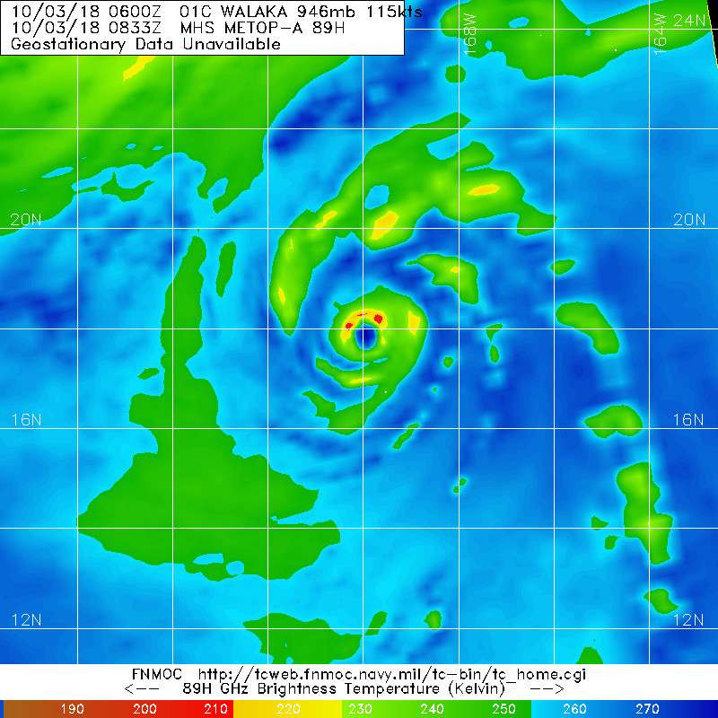
CPAC: WALAKA - Post-Tropical
Moderator: S2k Moderators
-
mrbagyo

- Category 5

- Posts: 3963
- Age: 33
- Joined: Thu Apr 12, 2012 9:18 am
- Location: 14.13N 120.98E
- Contact:
Re: CPAC: WALAKA - Hurricane
1 likes
The posts in this forum are NOT official forecast and should not be used as such. They are just the opinion of the poster and may or may not be backed by sound meteorological data. They are NOT endorsed by any professional institution or storm2k.org. For official information, please refer to RSMC, NHC and NWS products.
-
mrbagyo
- Category 5
- Posts: 3963
- Age: 33
- Joined: Thu Apr 12, 2012 9:18 am
- Location: 14.13N 120.98E
- Contact:
Re: CPAC: WALAKA - Hurricane
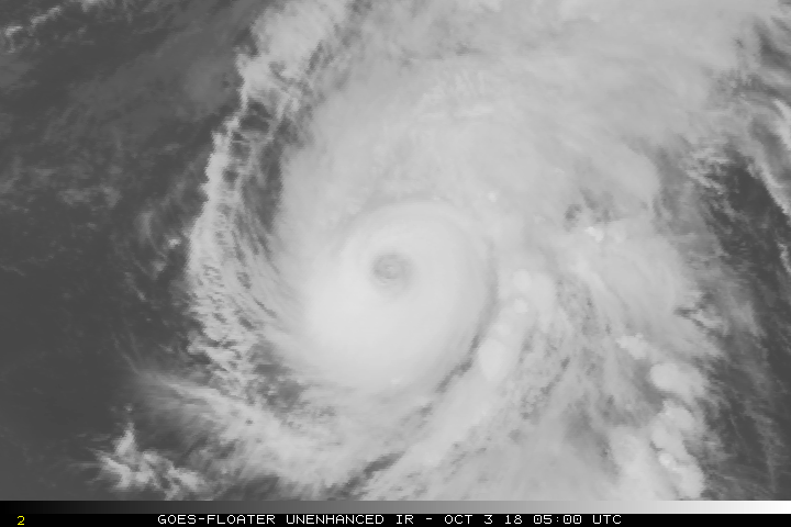
CI is back to 7.0
UW - CIMSS
ADVANCED DVORAK TECHNIQUE
ADT-Version 9.0
Tropical Cyclone Intensity Algorithm
----- Current Analysis -----
Date : 03 OCT 2018 Time : 093000 UTC
Lat : 18:07:12 N Lon : 169:56:59 W
CI# /Pressure/ Vmax
7.0 / 918.5mb/140.0kt
Final T# Adj T# Raw T#
7.0 7.0 7.0
Estimated radius of max. wind based on IR : 32 km
Center Temp : +11.8C Cloud Region Temp : -72.8C
Scene Type : EYE
Subtropical Adjustment : OFF
Extratropical Adjustment : OFF
Positioning Method : ARCHER POSITIONING
Ocean Basin : EAST PACIFIC
Dvorak CI > MSLP Conversion Used : CKZ Method
Tno/CI Rules : Constraint Limits : NO LIMIT
Weakening Flag : OFF
Rapid Dissipation Flag : OFF
C/K/Z MSLP Estimate Inputs :
- Average 34 knot radii : 135nmi
- Environmental MSLP : 1007mb
Satellite Name : GOES15
Satellite Viewing Angle : 44.9 degrees
0 likes
The posts in this forum are NOT official forecast and should not be used as such. They are just the opinion of the poster and may or may not be backed by sound meteorological data. They are NOT endorsed by any professional institution or storm2k.org. For official information, please refer to RSMC, NHC and NWS products.
-
mrbagyo
- Category 5
- Posts: 3963
- Age: 33
- Joined: Thu Apr 12, 2012 9:18 am
- Location: 14.13N 120.98E
- Contact:
Re: CPAC: WALAKA - Hurricane
SatCon is currently at 133 knots
0 likes
The posts in this forum are NOT official forecast and should not be used as such. They are just the opinion of the poster and may or may not be backed by sound meteorological data. They are NOT endorsed by any professional institution or storm2k.org. For official information, please refer to RSMC, NHC and NWS products.


Re: CPAC: WALAKA - Hurricane
Continues to impress
4 likes
The above post and any post by Ntxw is NOT an official forecast and should not be used as such. It is just the opinion of the poster and may or may not be backed by sound meteorological data. It is NOT endorsed by any professional institution including Storm2k. For official information, please refer to NWS products.
Help support Storm2K!

-
Extratropical94

- Professional-Met

- Posts: 3545
- Age: 31
- Joined: Wed Oct 20, 2010 6:36 am
- Location: Hamburg, Germany
- Contact:
Re: CPAC: WALAKA - Hurricane
Small bump to 120kt
01C WALAKA 181003 1200 18.8N 169.7W CPAC 120 942
0 likes
54° 11' 59'' N, 9° 9' 20'' E
Boomer Sooner!
Go Broncos! Go Cards!
Clinching counties, one at a time: https://mob-rule.com/user-gifs/USA/xtrp94.gif
- Daniel
Boomer Sooner!
Go Broncos! Go Cards!
Clinching counties, one at a time: https://mob-rule.com/user-gifs/USA/xtrp94.gif
- Daniel


Re: CPAC: WALAKA - Tropical Storm
Tropical Storm Walaka Discussion Number 25
NWS Central Pacific Hurricane Center Honolulu HI CP012018
1100 AM HST Fri Oct 05 2018
Walaka, which has been deteriorating steadily all night, is now
coming apart at the seams in satellite imagery. The exposed low
level circulation center (LLCC) is beginning to open up to the
west, with layered clouds and possibly a single warm-topped
cumulonimbus sputtering within the eastern quadrant. The latest
Dvorak current intensity estimates range from 1.5/25 kt from JTWC to
3.0/45 kt from PHFO. SAB estimated 2.0/30 kt while UW-CIMSS ADT was
39 kt. Based on these estimates, and with a nod to continuity, we
will assign an initial intensity of 45 kt for this advisory.
However, this may be generous given the poor satellite presentation
and the Dvorak constraints keeping the PHFO estimate high.
This weakening system is tracking just east of due north, with
initial motion of 030/10 kt. After moving northward over the past
few days along the western fringe of the subtropical ridge, Walaka
is beginning to respond to southwesterly steering ahead of a broad
north Pacific upper trough moving in from the northwest. This will
pick Walaka up and accelerate it off to the northeast through early
Sunday. Walaka is expected to begin extra-tropical transition
Saturday. The official forecast track is very close to that of the
previous advisory, staying within the very tight guidance envelope
centered along HWRF. The track terminates at 48 hours as Walaka
becomes absorbed by a mid-latitude low.
Walaka will move over increasingly cooler water along its truncated
track, while vertical wind shear dramatically ramps up, reaching 34
kt at 36 hours and 44 kt by 48 hours. Global models show Walaka
will be absorbed by a mid-latitude low by 48 hours, with weakening
and extratropical transition occurring simultaneously from 24 hours
through system dissipation at 48 hours. Our forecast follows the
HCCA weakening trend, which is also quite close to the IVCN curve.
FORECAST POSITIONS AND MAX WINDS
INIT 05/2100Z 32.2N 167.8W 45 KT 50 MPH
12H 06/0600Z 34.7N 166.2W 40 KT 45 MPH
24H 06/1800Z 39.4N 162.6W 35 KT 40 MPH...POST-TROP/EXTRATROP
36H 07/0600Z 45.7N 157.2W 30 KT 35 MPH...POST-TROP/EXTRATROP
48H 07/1800Z...DISSIPATED
$$
Forecaster Powell
0 likes
-
bob rulz
- Category 5
- Posts: 1711
- Age: 36
- Joined: Sat Jan 28, 2006 7:30 pm
- Location: Salt Lake City, Utah
Re: CPAC: WALAKA - Post-Tropical
Post-tropical now. Goodbye Walaka, you were quite the storm to look at for a short time.
2 likes
-
gigabite

- S2K Supporter

- Posts: 916
- Age: 72
- Joined: Wed May 05, 2004 4:09 pm
- Location: Naples, Florida
Re: CPAC: WALAKA - Post-Tropical
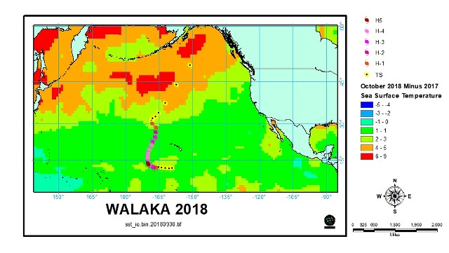
It is unusual that a system gets this far north.
1. Walaka 2018 got to 50
2. Lester 2016 got to 38.2
3. Ignacio 2015 got to 34.8
4. Ana 2014 got to 41.2
5. Guillermo 2009 got to 39.7
6. Fausto 2002 got to 43.1
7. Daniel 2000, 36.1
8. Guillermo 1997 got to 51.2
8 storms out of 652
1 likes

Re: CPAC: WALAKA - Post-Tropical
Walaka literally wiped out an island
https://weather.com/news/news/2018-10-2 ... ane-walaka
https://weather.com/news/news/2018-10-2 ... ane-walaka
At a Glance
Hawaii's East Island vanished overnight after being walloped by Hurricane Walaka.
Officials are unsure if the island will ever re-emerge.
The island was a crucial habitat for Hawaiian green sea turtles and monk seals.
Chip Fletcher always knew East Island would eventually be wiped off the map.
Fletcher, a climate scientist with the University of Hawaii, thought it would take decades for rising seas to eventually submerge the island. Instead, it was obliterated overnight by a major hurricane.
One of the most intense Pacific hurricanes on record at its peak, Walaka buzzed just 70 miles west of East Island as a major Category 3 hurricane with sustained winds of 125 mph, walloping Hawaii's Papahanaumokuakea Marine National Monument.
2 likes
ヤンデレ女が寝取られるているのを見たい!!!
ECMWF ensemble NWPAC plots: https://ecmwfensnwpac.imgbb.com/
Multimodel NWPAC plots: https://multimodelnwpac.imgbb.com/
GFS Ensemble NWPAC plots (16 & 35 day forecast): https://gefsnwpac.imgbb.com/
Plots updated automatically
ECMWF ensemble NWPAC plots: https://ecmwfensnwpac.imgbb.com/
Multimodel NWPAC plots: https://multimodelnwpac.imgbb.com/
GFS Ensemble NWPAC plots (16 & 35 day forecast): https://gefsnwpac.imgbb.com/
Plots updated automatically
Who is online
Users browsing this forum: No registered users and 21 guests