
WPAC: DORA - Post-Tropical - Discussion
Moderator: S2k Moderators
-
Sciencerocks
- Category 5

- Posts: 10193
- Age: 40
- Joined: Thu Jul 06, 2017 1:51 am
-
cycloneye

- Admin

- Posts: 149710
- Age: 69
- Joined: Thu Oct 10, 2002 10:54 am
- Location: San Juan, Puerto Rico
Re: EPAC: DORA - Hurricane - Discussion
Hurricane Dora Discussion Number 9
NWS National Hurricane Center Miami FL EP052023
1100 AM HST Wed Aug 02 2023
After the last advisory, we received a couple of late arriving
microwave passes, first from GPM at 1339 UTC, and then F-17 SSMIS at
1426 UTC. Both passes suggested that the inner core structure of
Dora could be rearranging some with concentric bands embedded in the
central dense overcast. On geostationary satellite, a tiny eye
signature keeps coming and going, more recently trying to become
better defined again as the surrounding cloud top temperatures have
cooled. Subjective intensity estimates of Dora were both 90 kt from
TAFB and SAB at 1800 UTC. Since that time, the eye has become more
distinct again, so the intensity is nudged upward to 95 kt for this
advisory. A helpful Synthetic Aperture Radar (SAR) pass received
this morning showed that Dora remains a very small hurricane, with
hurricane force winds only extending out 15 n mi from the center
with a tiny 5 n mi radius of maximum wind.
Dora's motion is essentially unchanged from this morning, still just
south of due west at 260/14 kt. A deep-layer ridge located to the
north of the hurricane is forecast to move with it, resulting in a
continued south of due west track through the entire forecast
period. The latest track guidance remains tightly clustered near the
previous forecast track, and only slight adjustments were made for
this advisory, blending the TVCE and HCCA consensus aids.
While Dora appears to have paused its intensification this
afternoon, it might just be a short-term fluctuation, as the latest
few 1-min GOES-18 infrared images over Dora show the eye trying to
clear out again. While SHIPS-RII has decreased some, especially
compared to yesterday, DTOPS still indicates a 64 to 67 percent
chance of a 25-kt increase in intensity over the next 24 hours. So
the latest NHC intensity forecast will continue to show a 115 kt
peak intensity over the next day, higher than the consensus aids,
but still lower than both the HAFS-A/B runs. Thereafter, sea-surface
temperatures begin to markedly decrease under the hurricane as
easterly vertical wind shear is forecast to increase some. The
models respond to this less favorable environment by showing
weakening between 36-72 hours, and the latest official forecast
also shows this scenario. As mentioned previously, Dora's small
size could make it susceptible to rapid intensity changes, both up
or down, and the intensity forecast is of much lower confidence
than the track forecast.
FORECAST POSITIONS AND MAX WINDS
INIT 02/2100Z 15.4N 115.6W 95 KT 110 MPH
12H 03/0600Z 15.2N 117.8W 105 KT 120 MPH
24H 03/1800Z 14.9N 120.7W 115 KT 130 MPH
36H 04/0600Z 14.5N 123.9W 105 KT 120 MPH
48H 04/1800Z 14.1N 127.1W 95 KT 110 MPH
60H 05/0600Z 13.7N 130.2W 85 KT 100 MPH
72H 05/1800Z 13.3N 133.3W 80 KT 90 MPH
96H 06/1800Z 12.6N 139.8W 80 KT 90 MPH
120H 07/1800Z 12.5N 146.9W 75 KT 85 MPH
$$
Forecaster Papin
0 likes
Visit the Caribbean-Central America Weather Thread where you can find at first post web cams,radars
and observations from Caribbean basin members Click Here
and observations from Caribbean basin members Click Here
-
Hurricane2022

- Category 5
- Posts: 2092
- Joined: Tue Aug 23, 2022 11:38 pm
- Location: Araçatuba, Brazil
Re: EPAC: DORA - Hurricane - Discussion
0 likes
Sorry for the bad English sometimes...!
For reliable and detailed information for any meteorological phenomenon, please consult the National Hurricane Center, Joint Typhoon Warning Center , or your local Meteo Center.
--------
ECCE OMNIA NOVA FACIAM (Ap 21,5).
For reliable and detailed information for any meteorological phenomenon, please consult the National Hurricane Center, Joint Typhoon Warning Center , or your local Meteo Center.
--------
ECCE OMNIA NOVA FACIAM (Ap 21,5).

Re: EPAC: DORA - Hurricane - Discussion
1 likes
TC naming lists: retirements and intensity
Most aggressive Advisory #1's in North Atlantic (cr. kevin for starting the list)
Most aggressive Advisory #1's in North Atlantic (cr. kevin for starting the list)
-
cycloneye
- Admin
- Posts: 149710
- Age: 69
- Joined: Thu Oct 10, 2002 10:54 am
- Location: San Juan, Puerto Rico
Re: EPAC: DORA - Hurricane - Discussion
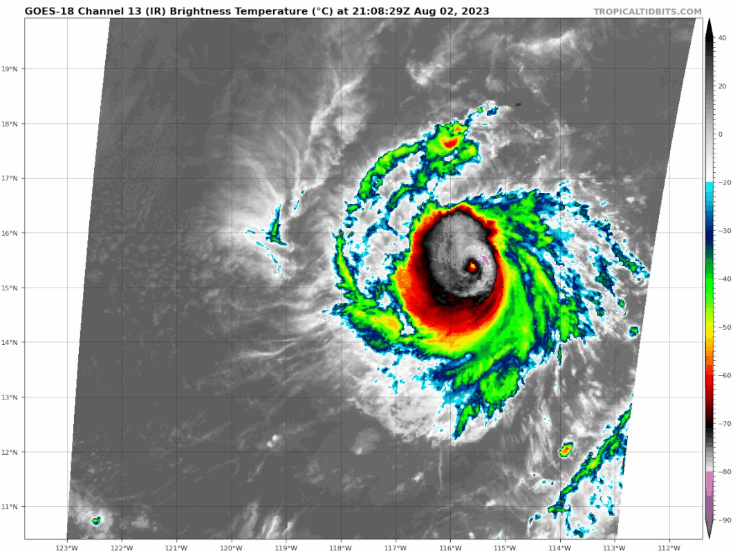
Closeup of the eye clearing.

1 likes
Visit the Caribbean-Central America Weather Thread where you can find at first post web cams,radars
and observations from Caribbean basin members Click Here
and observations from Caribbean basin members Click Here
-
Yellow Evan

- Professional-Met

- Posts: 16257
- Age: 27
- Joined: Fri Jul 15, 2011 12:48 pm
- Location: Henderson, Nevada/Honolulu, HI
- Contact:
Re: EPAC: DORA - Hurricane - Discussion

CDO very west weighted but also expanding. Eye is starting to warm. Sheared Category 4 pinhole inbound?
0 likes
-
Hurricane2022
- Category 5
- Posts: 2092
- Joined: Tue Aug 23, 2022 11:38 pm
- Location: Araçatuba, Brazil
Re: EPAC: DORA - Hurricane - Discussion
4 likes
Sorry for the bad English sometimes...!
For reliable and detailed information for any meteorological phenomenon, please consult the National Hurricane Center, Joint Typhoon Warning Center , or your local Meteo Center.
--------
ECCE OMNIA NOVA FACIAM (Ap 21,5).
For reliable and detailed information for any meteorological phenomenon, please consult the National Hurricane Center, Joint Typhoon Warning Center , or your local Meteo Center.
--------
ECCE OMNIA NOVA FACIAM (Ap 21,5).


Re: EPAC: DORA - Hurricane - Discussion
Very pretty.


4 likes
The above post and any post by Ntxw is NOT an official forecast and should not be used as such. It is just the opinion of the poster and may or may not be backed by sound meteorological data. It is NOT endorsed by any professional institution including Storm2k. For official information, please refer to NWS products.
Help support Storm2K!


Re: EPAC: DORA - Hurricane - Discussion
Dora reminds me a lot of Erick ‘19. Both were very tiny and compact pinholes, and Dora should also be able to reach Cat 4 intensity. I’m guessing around 115-120 kt before it levels off later tomorrow.
0 likes
Irene '11 Sandy '12 Hermine '16 5/15/2018 Derecho Fay '20 Isaias '20 Elsa '21 Henri '21 Ida '21
I am only a meteorology enthusiast who knows a decent amount about tropical cyclones. Look to the professional mets, the NHC, or your local weather office for the best information.
I am only a meteorology enthusiast who knows a decent amount about tropical cyclones. Look to the professional mets, the NHC, or your local weather office for the best information.
Re: EPAC: DORA - Hurricane - Discussion
Eye has warmed a lot. Dora is easily 100kts likely already on way to cat 4.

0 likes
The above post and any post by Ntxw is NOT an official forecast and should not be used as such. It is just the opinion of the poster and may or may not be backed by sound meteorological data. It is NOT endorsed by any professional institution including Storm2k. For official information, please refer to NWS products.
Help support Storm2K!
Help support Storm2K!
-
lilbump3000

- Category 4

- Posts: 966
- Age: 38
- Joined: Sat Sep 20, 2003 10:09 am
- Location: New Orleans, Louisiana
- Contact:

-
lilbump3000
- Category 4
- Posts: 966
- Age: 38
- Joined: Sat Sep 20, 2003 10:09 am
- Location: New Orleans, Louisiana
- Contact:


-
cycloneye
- Admin
- Posts: 149710
- Age: 69
- Joined: Thu Oct 10, 2002 10:54 am
- Location: San Juan, Puerto Rico
Re: EPAC: DORA - Hurricane - Discussion
5.5.
TXPZ21 KNES 030027
TCSENP
A. 05E (DORA)
B. 03/0000Z
C. 15.3N
D. 116.1W
E. ONE/GOES-W
F. T5.5/5.5
G. IR/EIR/VIS
H. REMARKS...OW EYE SURROUNDED BY W AND EMBEDDED IN LG RESULTS IN AN
E# OF 5.0 WITH EADJ +0.5 FOR A DT OF 5.5. EYE HAS BECOME WELL-DEFINED
LAST 6 HR. UPR-LVL OUTFLOW GOOD ALQDS. MET=5.0 AND PT=5.5. FT BASED ON
DT. SYSTEM MAY BE A BIT STRONGER THAN FT INDICATES DUE TO SMALL TC SIZE
LIMITATIONS WITH DVORAK.
I. ADDL POSITIONS
NIL
...KONON
0 likes
Visit the Caribbean-Central America Weather Thread where you can find at first post web cams,radars
and observations from Caribbean basin members Click Here
and observations from Caribbean basin members Click Here
Re: EPAC: DORA - Hurricane - Discussion
We knew it would be a problem with dvorak  .
.


2 likes
The above post and any post by Ntxw is NOT an official forecast and should not be used as such. It is just the opinion of the poster and may or may not be backed by sound meteorological data. It is NOT endorsed by any professional institution including Storm2k. For official information, please refer to NWS products.
Help support Storm2K!
Help support Storm2K!
-
Hurricane2022
- Category 5
- Posts: 2092
- Joined: Tue Aug 23, 2022 11:38 pm
- Location: Araçatuba, Brazil
Re: EPAC: DORA - Hurricane - Discussion
I'm somewhat surprised that NHC still hasn't issued a special advisory for Dora. This is very likely a mid-range C4 now.


4 likes
Sorry for the bad English sometimes...!
For reliable and detailed information for any meteorological phenomenon, please consult the National Hurricane Center, Joint Typhoon Warning Center , or your local Meteo Center.
--------
ECCE OMNIA NOVA FACIAM (Ap 21,5).
For reliable and detailed information for any meteorological phenomenon, please consult the National Hurricane Center, Joint Typhoon Warning Center , or your local Meteo Center.
--------
ECCE OMNIA NOVA FACIAM (Ap 21,5).
-
cycloneye
- Admin
- Posts: 149710
- Age: 69
- Joined: Thu Oct 10, 2002 10:54 am
- Location: San Juan, Puerto Rico
Re: EPAC: DORA - Hurricane - Discussion: 00z Best Track up to 110kt
110kt
EP, 05, 2023080300, , BEST, 0, 153N, 1162W, 110, 956, HU
1 likes
Visit the Caribbean-Central America Weather Thread where you can find at first post web cams,radars
and observations from Caribbean basin members Click Here
and observations from Caribbean basin members Click Here
-
lilbump3000
- Category 4
- Posts: 966
- Age: 38
- Joined: Sat Sep 20, 2003 10:09 am
- Location: New Orleans, Louisiana
- Contact:

Re: EPAC: DORA - Hurricane - Discussion: 00z Best Track up to 110kt
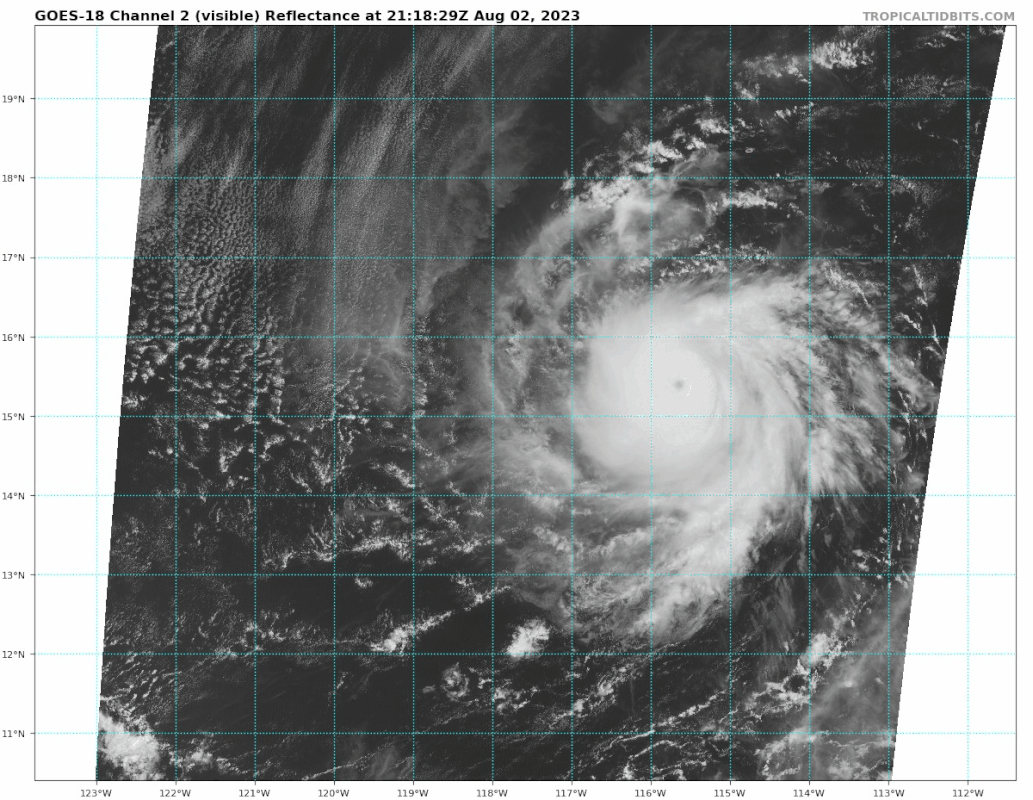
That is a pinhole eye if there ever is one.

2 likes
The above post and any post by Ntxw is NOT an official forecast and should not be used as such. It is just the opinion of the poster and may or may not be backed by sound meteorological data. It is NOT endorsed by any professional institution including Storm2k. For official information, please refer to NWS products.
Help support Storm2K!
Help support Storm2K!
-
lilbump3000
- Category 4
- Posts: 966
- Age: 38
- Joined: Sat Sep 20, 2003 10:09 am
- Location: New Orleans, Louisiana
- Contact:

-
Yellow Evan
- Professional-Met
- Posts: 16257
- Age: 27
- Joined: Fri Jul 15, 2011 12:48 pm
- Location: Henderson, Nevada/Honolulu, HI
- Contact:
Re: EPAC: DORA - Hurricane - Discussion: 00z Best Track up to 110kt

On the brink of T7.0. Pretty classic high end EPAC pinhole with very impressive CDO in terms of symmetry.
0 likes
Who is online
Users browsing this forum: No registered users and 54 guests