NATL: IMELDA - Post-Tropical - Discussion
Moderator: S2k Moderators
- HurricaneAndre2008
- Category 1

- Posts: 356
- Age: 28
- Joined: Wed Jul 31, 2019 9:51 pm
- Contact:
Re: NATL: INVEST 94L - Discussion (80/90)
1 likes
Cindy(2005), Katrina(2005), Rita(2005), Erin(2007), Isaac(2012)
- TTARider
- Tropical Low

- Posts: 25
- Age: 49
- Joined: Wed Jun 02, 2010 2:53 pm
- Location: Sanford, Florida
- Contact:
Re: NATL: INVEST 94L - Discussion (80/90)
am I the only one who thinks this system may Init on or just below the current forecasted init? looks broad right now.
0 likes
- TTARider
- wxman57
- Moderator-Pro Met

- Posts: 23170
- Age: 68
- Joined: Sat Jun 21, 2003 8:06 pm
- Location: Houston, TX (southwest)
Re: NATL: INVEST 94L - Discussion (80/90)
I think that the only TS watches initially will be for the Bahamas. Any TS wind for Florida is more than 48 hrs away. It may not have much of a western side initially.
1 likes
- galaxy401
- Category 5

- Posts: 2446
- Age: 30
- Joined: Sat Aug 25, 2012 9:04 pm
- Location: Casa Grande, Arizona
Re: NATL: INVEST 94L - Discussion (80/90)
Will this disturbance be potentially weaker if Humberto strengthens faster then expected?
0 likes
Got my eyes on moving right into Hurricane Alley: Florida.
-
tolakram
- Admin

- Posts: 20172
- Age: 62
- Joined: Sun Aug 27, 2006 8:23 pm
- Location: Florence, KY (name is Mark)
Re: NATL: INVEST 94L - Discussion (80/90)
saved loop


1 likes
M a r k
- - - - -
Join us in chat: Storm2K Chatroom Invite. Android and IOS apps also available.
The posts in this forum are NOT official forecasts and should not be used as such. Posts are NOT endorsed by any professional institution or STORM2K.org. For official information and forecasts, please refer to NHC and NWS products.
Re: NATL: INVEST 94L - Discussion (80/90)
galaxy401 wrote:Will this disturbance be potentially weaker if Humberto strengthens faster then expected?
It will be potentially weaker if the trough off Texas digs deep into the gulf.
We've seen that happen with October storms before.
poof
0 likes
-
tolakram
- Admin

- Posts: 20172
- Age: 62
- Joined: Sun Aug 27, 2006 8:23 pm
- Location: Florence, KY (name is Mark)
Re: NATL: INVEST 94L - Discussion (80/90)
4 likes
M a r k
- - - - -
Join us in chat: Storm2K Chatroom Invite. Android and IOS apps also available.
The posts in this forum are NOT official forecasts and should not be used as such. Posts are NOT endorsed by any professional institution or STORM2K.org. For official information and forecasts, please refer to NHC and NWS products.
- - - - -
Join us in chat: Storm2K Chatroom Invite. Android and IOS apps also available.
The posts in this forum are NOT official forecasts and should not be used as such. Posts are NOT endorsed by any professional institution or STORM2K.org. For official information and forecasts, please refer to NHC and NWS products.
-
CrazyC83
- Professional-Met

- Posts: 34311
- Joined: Tue Mar 07, 2006 11:57 pm
- Location: Deep South, for the first time!
NATL: INVEST 94L - Models
At this point, it may end up in the eastern Gulf?
I agree that there will be a stall at some point. Could Diana 1984 be an analog?
I agree that there will be a stall at some point. Could Diana 1984 be an analog?
0 likes
Re: NATL: INVEST 94L - Discussion (80/90)
No PTC yet, which is odd considering it'll be in the Bahamas in about 24 hours.
1 likes
- cycloneye
- Admin

- Posts: 149121
- Age: 69
- Joined: Thu Oct 10, 2002 10:54 am
- Location: San Juan, Puerto Rico
Re: NATL: INVEST 94L - Discussion (80/90)
BobHarlem wrote:No PTC yet, which is odd considering it'll be in the Bahamas in about 24 hours.
They may be waiting for it to get away from Hispañiola and recon will be there to do the low level invest on friday afternoon.
0 likes
Visit the Caribbean-Central America Weather Thread where you can find at first post web cams,radars
and observations from Caribbean basin members Click Here
and observations from Caribbean basin members Click Here
-
TomballEd
- Category 5

- Posts: 1242
- Age: 62
- Joined: Wed Aug 16, 2023 4:52 pm
- Location: Spring/Klein area, not Tomball
Re: NATL: INVEST 94L - Discussion (80/90)
cycloneye wrote:BobHarlem wrote:No PTC yet, which is odd considering it'll be in the Bahamas in about 24 hours.
They may be waiting for it to get away from Hispañiola and recon will be there to do the low level invest on friday afternoon.
They don't need a closed circulation that recon could find for a PTC. The whole reason for the PTC. To issue watches and warnings for a storm that has not yet formed but has a high probability of forming. I wonder if the government of Bahamas did not want to issue warnings.
1 likes
- Blown Away
- S2K Supporter

- Posts: 10253
- Joined: Wed May 26, 2004 6:17 am
Re: NATL: INVEST 94L - Discussion (80/90)

AL, 94, 2025092518, , BEST, 0, 205N, 717W, 25, 1011, DB
Not much of a circulation and to me it's moving almost due W and a pretty raid pace.
0 likes
Hurricane Eye Experience: David 79, Irene 99, Frances 04, Jeanne 04, Wilma 05… Hurricane Brush Experience: Andrew 92, Erin 95, Floyd 99, Matthew 16, Irma 17, Ian 22, Nicole 22…
Re: NATL: INVEST 94L - Discussion (80/90)
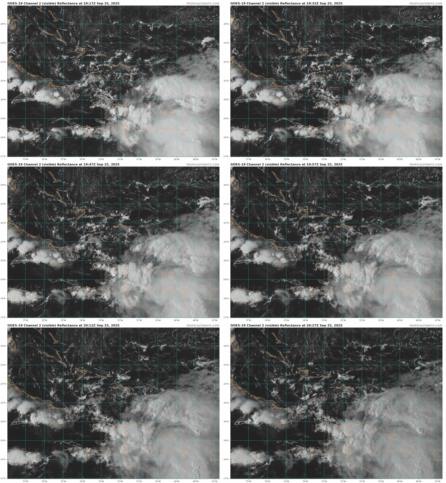
To me it looks like if it has a semi-defined center, it looks like its currently over the DR, despite what NHC is showing as a bit further north. I'm not sure we are going to see it classified until at least tomorrow.
1 likes
Re: NATL: INVEST 94L - Discussion (80/90)
Right on que at sunset, big blowup over Haiti.
A done deal once it gets over water
A done deal once it gets over water
2 likes
Re: NATL: INVEST 94L - Discussion (80/90)
LLC at 20N 73.3W, NW tip of Haiti
I would name it once it hits the water
https://rammb-data.cira.colostate.edu/t ... 0_swnd.gif
I would name it once it hits the water
https://rammb-data.cira.colostate.edu/t ... 0_swnd.gif
1 likes
Re: NATL: INVEST 94L - Discussion (80/90)
GCANE wrote:LLC at 20N 73.3W, NW tip of Haiti
I would name it once it hits the water
https://rammb-data.cira.colostate.edu/t ... 0_swnd.gif
It seems like a prime candidate for PTC at the minimum.
1 likes
-
Hurricane Mike
- Category 2

- Posts: 675
- Joined: Tue Apr 10, 2018 7:44 am
Re: NATL: INVEST 94L - Discussion (80/90)
Also in agreement with others- not quite sure why this isn’t a PTC given the likelihood of impacts in the Bahamas within a day. Maybe the NHC is planning to just go ahead and pull the trigger on naming this at the next advisory instead, but it doesn’t seem to be quite there yet structurally.
0 likes
- Blown Away
- S2K Supporter

- Posts: 10253
- Joined: Wed May 26, 2004 6:17 am
Re: NATL: INVEST 94L - Discussion (80/90)
GCANE wrote:LLC at 20N 73.3W, NW tip of Haiti
I would name it once it hits the water
https://rammb-data.cira.colostate.edu/t ... 0_swnd.gif
Nice find! I do think ultimately 94L and Humberto will find enough separation to avoid this fujiwara scenario. I think the separation will be 94L finding itself farther W over the next 36 hours. If your NW tip of Haiti is right then it’s an already a degree farther S and W than predicted.
1 likes
Hurricane Eye Experience: David 79, Irene 99, Frances 04, Jeanne 04, Wilma 05… Hurricane Brush Experience: Andrew 92, Erin 95, Floyd 99, Matthew 16, Irma 17, Ian 22, Nicole 22…
- wxman57
- Moderator-Pro Met

- Posts: 23170
- Age: 68
- Joined: Sat Jun 21, 2003 8:06 pm
- Location: Houston, TX (southwest)
Re: NATL: INVEST 94L - Models
CrazyC83 wrote:At this point, it may end up in the eastern Gulf?
I agree that there will be a stall at some point. Could Diana 1984 be an analog?
Eastern Gulf would be very, very unlikely.
3 likes
Who is online
Users browsing this forum: No registered users and 15 guests


