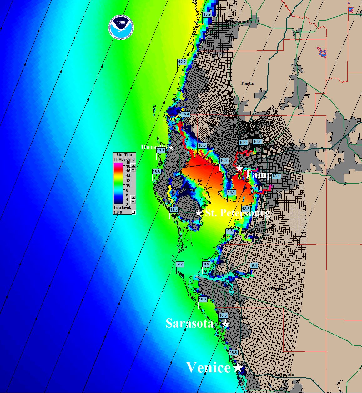
ATL: IAN - Post-Tropical - Discussion

Moderator: S2k Moderators

Message
Author
User avatar
sittingduck
S2K Supporter
S2K Supporter
Posts: 111
Joined: Mon Aug 13, 2007 3:16 pm
Location: venice florida

Re: ATL: IAN - Tropical Storm - Discussion

#1441 Postby sittingduck » Sun Sep 25, 2022 11:44 am

robbielyn wrote:
ConvergenceZone wrote:I know that the flooding can be really bad, but I think we should all be grateful of the amount of shear that's forecasted to be in the northern gulf.... I can't even imagine how horrible this situation would have been if the conditions were great for intensification, rather than weakening. Cat 1 to maybe Cat 2 seems the most likely strength at landfall... .. I'm not really concerned about the wind as much though, except on the coast... I'm concerned about the rain/surge, especially if the EURO wins out and there's more of a stall over Florida......

i’m 14 miles inland is that safe from wind and surge?

It really depends on where you are located for both and where Ian goes and strength. Lots of damage inland from Charlie. best to ask this in the discussion forum though and post with your location to get better info
1 likes   

StormPyrate
Category 1
Category 1
Posts: 279
Joined: Sun May 27, 2018 8:41 pm
Location: Clearwater, FL

Re: ATL: IAN - Tropical Storm - Discussion

#1442 Postby StormPyrate » Sun Sep 25, 2022 11:44 am

there used to be a resource where you could see timed predicted conditions by major cities. So for example to see Clearwater Beach over time as a storm approaches.
Do they still have that, could not find it on NHC
1 likes   
St Petersburg Florida

underthwx
Category 5
Category 5
Posts: 2360
Joined: Sat Jul 30, 2011 2:14 pm
Location: Brazoria County Texas

Re: ATL: IAN - Tropical Storm - Discussion

#1443 Postby underthwx » Sun Sep 25, 2022 11:46 am

ScottNAtlanta wrote:It is finally stacked. This is just one big burst over the center from going to town


Yes, looking at satellite imagery animated of Ian, it appears to be wrapping itself up unfortunately....
1 likes   

skillz305
Category 1
Category 1
Posts: 279
Joined: Sat Sep 08, 2018 11:10 am
Location: Miami, Florida --> Vero Beach, Florida

Re: ATL: IAN - Tropical Storm - Discussion

#1444 Postby skillz305 » Sun Sep 25, 2022 11:47 am

I feel as if the center is already at 15.75N
Last edited by skillz305 on Sun Sep 25, 2022 11:50 am, edited 1 time in total.
1 likes   
:flag:Hurricanes: Andrew 1992 - Irene 1999 - Frances 2004 - Jeanne 2004 - Katrina 2005 - Wilma 2005 - Matthew 2016 - Irma 2017 - Ian 2022 - Nicole 2022 - Milton 2024

Comradez
Tropical Low
Tropical Low
Posts: 32
Joined: Mon Aug 22, 2011 10:21 pm

Re: ATL: IAN - Tropical Storm - Discussion

#1445 Postby Comradez » Sun Sep 25, 2022 11:48 am

It is starting to get some spiral banding and is looking suddenly much more symmetrical and organized. Fewer thunderstorms in the outer bands are collapsing into outflow boundaries. Dry air is getting mixed out. Just needs a deep CDO to develop and it will be near hurricane status. My guess is, by 5am tomorrow morning it will be a Cat 1 hurricane.
1 likes   

User avatar
NDG
S2K Supporter
S2K Supporter
Posts: 15446
Joined: Sun Jul 09, 2006 10:14 pm
Location: Orlando, FL

Re: ATL: IAN - Tropical Storm - Discussion

#1446 Postby NDG » Sun Sep 25, 2022 11:49 am

A definite NW heading has started with Ian if not a NNW heading, LLC much more defined than yesterday.

Image
13 likes   

NAVAIDNICK
Tropical Low
Tropical Low
Posts: 26
Age: 46
Joined: Sun Jul 04, 2021 4:48 pm
Location: North Port, FL

Re: ATL: IAN - Tropical Storm - Discussion

#1447 Postby NAVAIDNICK » Sun Sep 25, 2022 11:50 am

robbielyn wrote:
ConvergenceZone wrote:I know that the flooding can be really bad, but I think we should all be grateful of the amount of shear that's forecasted to be in the northern gulf.... I can't even imagine how horrible this situation would have been if the conditions were great for intensification, rather than weakening. Cat 1 to maybe Cat 2 seems the most likely strength at landfall... .. I'm not really concerned about the wind as much though, except on the coast... I'm concerned about the rain/surge, especially if the EURO wins out and there's more of a stall over Florida......

i’m 14 miles inland is that safe from wind and surge?


There are way too many factors for anyone to make that determination for you. It depends on where the storm actually makes landfall and your relation to it (distance and direction), your elevation, the type and quality of structure you live in, etc. Consult with your local officials. Know your evacuation zone. One rule of thumb is that you run from water and hide from wind (unless you live in a mobile home where you should just evacuate no matter what). Then try to make a determination based on all the information that you have. That's all anyone can do.
2 likes   

Sanibel
Category 5
Category 5
Posts: 10375
Joined: Mon Aug 30, 2004 11:06 pm
Location: Offshore SW Florida

ATL: IAN - Tropical Storm - Discussion

#1448 Postby Sanibel » Sun Sep 25, 2022 11:52 am

NDG wrote:A definite NW heading has started with Ian if not a NNW heading, LLC much more defined than yesterday.


https://i.imgur.com/EgfqkZx.gif


The motion over the next 12 hours will be critical to the track...


That loop says what it looks like and clearly-seen strengthening is about to occur...
1 likes   

underthwx
Category 5
Category 5
Posts: 2360
Joined: Sat Jul 30, 2011 2:14 pm
Location: Brazoria County Texas

Re: ATL: IAN - Tropical Storm - Discussion

#1449 Postby underthwx » Sun Sep 25, 2022 11:53 am

NDG wrote:A definite NW heading has started with Ian if not a NNW heading, LLC much more defined than yesterday.

https://i.imgur.com/EgfqkZx.gif


Certainly better organized than previously, I looked at visible satellite of Ian, looking more and more impressive...
1 likes   

User avatar
pgoss11
Category 2
Category 2
Posts: 702
Joined: Tue Sep 02, 2003 3:55 pm

Re: ATL: IAN - Tropical Storm - Discussion

#1450 Postby pgoss11 » Sun Sep 25, 2022 11:55 am

NDG wrote:A definite NW heading has started with Ian if not a NNW heading, LLC much more defined than yesterday.

https://i.imgur.com/EgfqkZx.gif

A NNW heading this early would be bad news for the peninsula.
3 likes   

skillz305
Category 1
Category 1
Posts: 279
Joined: Sat Sep 08, 2018 11:10 am
Location: Miami, Florida --> Vero Beach, Florida

Re: ATL: IAN - Tropical Storm - Discussion

#1451 Postby skillz305 » Sun Sep 25, 2022 11:56 am

pgoss11 wrote:
NDG wrote:A definite NW heading has started with Ian if not a NNW heading, LLC much more defined than yesterday.

https://i.imgur.com/EgfqkZx.gif

A NNW heading this early would be bad news for the peninsula.


I won't lie, it looks NNW. :double:
1 likes   
:flag:Hurricanes: Andrew 1992 - Irene 1999 - Frances 2004 - Jeanne 2004 - Katrina 2005 - Wilma 2005 - Matthew 2016 - Irma 2017 - Ian 2022 - Nicole 2022 - Milton 2024

User avatar
cycloneye
Admin
Admin
Posts: 145327
Age: 68
Joined: Thu Oct 10, 2002 10:54 am
Location: San Juan, Puerto Rico

Re: ATL: IAN - Tropical Storm - Discussion

#1452 Postby cycloneye » Sun Sep 25, 2022 11:59 am

NDG wrote:A definite NW heading has started with Ian if not a NNW heading, LLC much more defined than yesterday.

https://i.imgur.com/EgfqkZx.gif


Let's see when recon arrives later in the afternoon, Let's watch for the pressure falls below 1000 mbs and if the winds go up. So far the past missions have not found winds very strong over 50kt.
2 likes   
Visit the Caribbean-Central America Weather Thread where you can find at first post web cams,radars
and observations from Caribbean basin members Click Here

Poonwalker
Category 1
Category 1
Posts: 270
Joined: Tue Sep 20, 2022 11:12 am

Re: ATL: IAN - Tropical Storm - Discussion

#1453 Postby Poonwalker » Sun Sep 25, 2022 11:59 am

beachnut wrote:
Jr0d wrote:


That is a but concerning to see so much area vulnerable to 15'+ of surge. With Ian, I hope the compact size will limit surge.

My grandmom and aunt live in the Clearwater/Safety Harbor area. My grandmom's place is the stronger structure and around 30' above sea level. I will have to give them a call soon and see what their plan is. With her being 95 years old evacuating is difficult but not as bad having no power for an extended period of time.


My wife's family all lives up in Pinellas, we need to give them a call too. We lived in Seminole before we moved to the Fort Myers area in '97. I know there's a lot of high spots in Pinellas, especially along the ridge from about Bellair down through south Seminole, maybe elsewhere too, but with massive surge forecasts it's tricky. Where we are now in Lee county just about everything west of US41 is in a flood/surge zone with few exceptions.

I use this surge site that shows inundation above ground: https://cera.coastalrisk.live/ . Use the drop-down to show the latest advisory.The NHC used to have one on their storm graphics page, not sure where it went.

She’s going to likely have no power for days and streets flooded if Tampa takes even a close approach from the west. I would consider going inland or even south inland if this trend keeps up. Rent a hotel if needed. It’s going to be a tough call for a lot of people unfortunately. We should have a better idea of impact areas by tomorrow morning if that leaves you the time needed.
Last edited by Poonwalker on Sun Sep 25, 2022 12:04 pm, edited 1 time in total.
1 likes   

User avatar
toad strangler
S2K Supporter
S2K Supporter
Posts: 4543
Joined: Sun Jul 28, 2013 3:09 pm
Location: Earth
Contact:

Re: ATL: IAN - Tropical Storm - Discussion

#1454 Postby toad strangler » Sun Sep 25, 2022 12:00 pm

skillz305 wrote:
pgoss11 wrote:
NDG wrote:A definite NW heading has started with Ian if not a NNW heading, LLC much more defined than yesterday.

https://i.imgur.com/EgfqkZx.gif

A NNW heading this early would be bad news for the peninsula.


I won't lie, it looks NNW. :double:


ahhh the ol satellite loop direction tricks to the eyes .... :D
8 likes   

tolakram
Admin
Admin
Posts: 20009
Age: 62
Joined: Sun Aug 27, 2006 8:23 pm
Location: Florence, KY (name is Mark)

Re: ATL: IAN - Tropical Storm - Discussion

#1455 Postby tolakram » Sun Sep 25, 2022 12:02 pm

I watch an airplane enthusiast from Tampa. He calmly stated he has a hotel room booked and is ready to bug out if needed. Not everyone has that flexibility, we have to remember, so the last minute wait might sound maddening but is sometimes required.
7 likes   
M a r k
- - - - -
Join us in chat: Storm2K Chatroom Invite. Android and IOS apps also available.

The posts in this forum are NOT official forecasts and should not be used as such. Posts are NOT endorsed by any professional institution or STORM2K.org. For official information and forecasts, please refer to NHC and NWS products.

User avatar
Iceresistance
Category 5
Category 5
Posts: 9288
Age: 21
Joined: Sat Oct 10, 2020 9:45 am
Location: Tecumseh, OK/Norman, OK

Re: ATL: IAN - Tropical Storm - Discussion

#1456 Postby Iceresistance » Sun Sep 25, 2022 12:03 pm

AF302 and AF304 are moving to a base that is closer to Ian. That is why you will see "Unassigned Mission" on the Tropical Tidbits Recon page.
3 likes   
Bill 2015 & Beta 2020

Winter 2020-2021 :cold:

All observations are in Tecumseh, OK unless otherwise noted.

Winter posts are focused mainly for Oklahoma & Texas.

Take any of my forecasts with a grain of salt, refer to the NWS, SPC, and NHC for official information

Never say Never with weather! Because ANYTHING is possible!

User avatar
ronjon
Category 5
Category 5
Posts: 4822
Joined: Fri Aug 19, 2005 5:17 pm
Location: Hernando Beach, FL

Re: ATL: IAN - Tropical Storm - Discussion

#1457 Postby ronjon » Sun Sep 25, 2022 12:04 pm

robbielyn wrote:
ConvergenceZone wrote:I know that the flooding can be really bad, but I think we should all be grateful of the amount of shear that's forecasted to be in the northern gulf.... I can't even imagine how horrible this situation would have been if the conditions were great for intensification, rather than weakening. Cat 1 to maybe Cat 2 seems the most likely strength at landfall... .. I'm not really concerned about the wind as much though, except on the coast... I'm concerned about the rain/surge, especially if the EURO wins out and there's more of a stall over Florida......

i’m 14 miles inland is that safe from wind and surge?


Safe from surge...wind and rainfall will be high.
1 likes   

caneman
Category 5
Category 5
Posts: 1447
Joined: Fri Sep 05, 2014 5:44 am
Location: Clearwater Beach, Fl

Re: ATL: IAN - Tropical Storm - Discussion

#1458 Postby caneman » Sun Sep 25, 2022 12:07 pm

Poonwalker wrote:
beachnut wrote:
Jr0d wrote:
That is a but concerning to see so much area vulnerable to 15'+ of surge. With Ian, I hope the compact size will limit surge.

My grandmom and aunt live in the Clearwater/Safety Harbor area. My grandmom's place is the stronger structure and around 30' above sea level. I will have to give them a call soon and see what their plan is. With her being 95 years old evacuating is difficult but not as bad having no power for an extended period of time.


My wife's family all lives up in Pinellas, we need to give them a call too. We lived in Seminole before we moved to the Fort Myers area in '97. I know there's a lot of high spots in Pinellas, especially along the ridge from about Bellair down through south Seminole, maybe elsewhere too, but with massive surge forecasts it's tricky. Where we are now in Lee county just about everything west of US41 is in a flood/surge zone with few exceptions.

I use this surge site that shows inundation above ground: https://cera.coastalrisk.live/ . Use the drop-down to show the latest advisory.The NHC used to have one on their storm graphics page, not sure where it went.

She’s going to likely have no power for days and streets if Tampa takes even a close approach from the west. I would consider going inland or even south inland if this trend keeps up. Rent a hotel if needed. It’s going to be a tough call for a lot of people unfortunately. We should have a better idea of impact areas by tomorrow morning if that leaves you the time needed.


I live near the higher area of Belleair. I'll be high and dry but everything else around me will be flooded.
Hopefully theyre stocked up. Got my generator, charcoal, water, beer and Kayaks so good to go. Lost power for 6 days each for Frances and Jeanne and 5 days for Irma.
Last edited by caneman on Sun Sep 25, 2022 12:10 pm, edited 1 time in total.
2 likes   

LARanger
Tropical Storm
Tropical Storm
Posts: 131
Joined: Wed Oct 07, 2020 12:45 pm

Re: ATL: IAN - Tropical Storm - Discussion

#1459 Postby LARanger » Sun Sep 25, 2022 12:07 pm

HeeBGBz wrote:
cane5 wrote:Can anyone say what percentage of chances Ian moves even move more west by the time it arrives in the Gulf thanks in advance :wink:


I think it will. I have no expertise in meteorology but I've seen storms come into the gulf from Caribbean that kept west when it was expected to turn east. Then when it actually turns east comes to the north gulf coast. My weatherbones are howling achey and my gut always thinks storms coming to get me. Anyway I relate more to the gfs without the crack.

:rain:


Okay, so it's not just me. I mean, I dismiss this sort of thing as mere meteorological paranoia, but -- after just about every 2020 Gulf storm NHC trackline pointed at my house at some point, and then Ida tried to touch me on the buttocks -- I tend to dismiss meteorological paranoia rather slowly, as in "it's about to make landfall somewhere else" slowly.
4 likes   
Baton Rouge area cyclone dilettante, PSWAGGER* tropical weather & hydrology model developer
(* Pseudo-Scientific Wild-A** Guesses Generally Expressed Ridiculously)
The GFDL would've had all this figured out by now.

skillz305
Category 1
Category 1
Posts: 279
Joined: Sat Sep 08, 2018 11:10 am
Location: Miami, Florida --> Vero Beach, Florida

Re: ATL: IAN - Tropical Storm - Discussion

#1460 Postby skillz305 » Sun Sep 25, 2022 12:08 pm

toad strangler wrote:
skillz305 wrote:
pgoss11 wrote:A NNW heading this early would be bad news for the peninsula.


I won't lie, it looks NNW. :double:


ahhh the ol satellite loop direction tricks to the eyes .... :D


My eyes are definitely strained but who knows :lol: it’s time for football - gonna be an interesting EURO and 2pm advisory - Go Dolphins!
4 likes   
:flag:Hurricanes: Andrew 1992 - Irene 1999 - Frances 2004 - Jeanne 2004 - Katrina 2005 - Wilma 2005 - Matthew 2016 - Irma 2017 - Ian 2022 - Nicole 2022 - Milton 2024


Return to “2022”

Who is online

Users browsing this forum: No registered users and 3 guests