Texas Spring 2019

U.S. & Caribbean Weather Discussions and Severe Weather Events

Moderator: S2k Moderators

Forum rules

The posts in this forum are NOT official forecast and should not be used as such. They are just the opinion of the poster and may or may not be backed by sound meteorological data. They are NOT endorsed by any professional institution or STORM2K.

Help Support Storm2K
Message
Author
Brent
S2K Supporter
S2K Supporter
Posts: 38089
Age: 36
Joined: Sun May 16, 2004 10:30 pm
Location: Tulsa Oklahoma
Contact:

Re: Texas Spring 2019

#1461 Postby Brent » Wed May 15, 2019 8:05 pm

starsfan65 wrote:
Brent wrote:
rwfromkansas wrote:Steve McCauley said Saturday is a morning complex for DFW. That would seem to significantly lower severe chances...again.


yeah NBC 5 looked like a lunch deal and mentioned the same thing
They don't think is going to be an afternoon
and evening deal?


Models can change, it is still 3 days out but that's what it looks like now, like a line late morning early afternoon then it moves east
0 likes   
#neversummer

User avatar
starsfan65
Category 2
Category 2
Posts: 704
Age: 47
Joined: Thu Dec 17, 2015 1:18 pm
Location: Garland,Tx

Re: Texas Spring 2019

#1462 Postby starsfan65 » Wed May 15, 2019 10:13 pm

Brent wrote:
starsfan65 wrote:
Brent wrote:
yeah NBC 5 looked like a lunch deal and mentioned the same thing
They don't think is going to be an afternoon
and evening deal?


Models can change, it is still 3 days out but that's what it looks like now, like a line late morning early afternoon then it moves east
Can we still get severe weather?
0 likes   

Brent
S2K Supporter
S2K Supporter
Posts: 38089
Age: 36
Joined: Sun May 16, 2004 10:30 pm
Location: Tulsa Oklahoma
Contact:

Re: Texas Spring 2019

#1463 Postby Brent » Wed May 15, 2019 11:03 pm

starsfan65 wrote:
Brent wrote:
starsfan65 wrote:They don't think is going to be an afternoon
and evening deal?


Models can change, it is still 3 days out but that's what it looks like now, like a line late morning early afternoon then it moves east
Can we still get severe weather?


of course... even if its a line it could still have at least some wind or hail or even a spinup I'm sure. We've had some severe that way already this spring.
0 likes   
#neversummer

weatherdude1108
Category 5
Category 5
Posts: 4228
Joined: Tue Dec 13, 2011 1:04 pm
Location: Northwest Austin/Cedar Park, TX

Re: Texas Spring 2019

#1464 Postby weatherdude1108 » Thu May 16, 2019 9:31 am

Brent wrote:
starsfan65 wrote:
Brent wrote:
Models can change, it is still 3 days out but that's what it looks like now, like a line late morning early afternoon then it moves east
Can we still get severe weather?


of course... even if its a line it could still have at least some wind or hail or even a spinup I'm sure. We've had some severe that way already this spring.


The recent NAM shows a solid line from Oklahoma down to San Antonio, departing Austin by 1pm, kind of like we had down here a week ago (similar time frame).
There was a lot of lightning in that one a week ago! I stayed away from windows because of the lightning.
1 likes   
The preceding post is NOT an official forecast, and should not be used as such. It is only the opinion of the poster and may or may not be backed by sound meteorological data. It is NOT endorsed by any professional institution including storm2k.org. For Official Information please refer to the NHC and NWS products.

rwfromkansas
Category 5
Category 5
Posts: 2627
Joined: Sat Aug 27, 2005 12:47 am
Location: North Fort Worth

Re: Texas Spring 2019

#1465 Postby rwfromkansas » Thu May 16, 2019 12:28 pm

Well, guess they will cancel the Keller Farmer's Market again.
0 likes   

Lagreeneyes03
Category 2
Category 2
Posts: 558
Joined: Mon Dec 09, 2013 10:53 am
Location: Luxurious Lake Grapevine

Re: Texas Spring 2019

#1466 Postby Lagreeneyes03 » Thu May 16, 2019 1:57 pm

rwfromkansas wrote:Well, guess they will cancel the Keller Farmer's Market again.


With the way this is getting hyped up again, I'm surprised that they just don't cancel Texas. Texas is cancelled this weekend. Hide yo kids, Hide yo wife,
3 likes   
I'm a Princess, not a forecaster.

User avatar
TheProfessor
Professional-Met
Professional-Met
Posts: 3506
Age: 28
Joined: Tue Dec 03, 2013 10:56 am
Location: Wichita, Kansas

Re: Texas Spring 2019

#1467 Postby TheProfessor » Thu May 16, 2019 2:28 pm

12Km NAM seems to be quite a bit slower and has more of a broken line than the 3Km NAM. If this were to happen things could get pretty bad in East Texas. I saw perhaps a hint of VBV on one of the NAM soundings I clicked on, but other nearby soundings didn't have any. STP is nearly off the charts on the NAM as well as supercell parameters. If the NAM continues this slower solution with these high parameters I wouldn't be surprised to see a Day 1 moderate risk out for East Texas. If the HRRR and other high resolution models show supercells forming out ahead of the squall line then I think there's even a possibility for a high risk, though I'm not sure if SPC would be confident enough to pull one even if high resolution models support it.
1 likes   
An alumnus of The Ohio State University.

Your local National Weather Service office is your best source for weather information.

Brent
S2K Supporter
S2K Supporter
Posts: 38089
Age: 36
Joined: Sun May 16, 2004 10:30 pm
Location: Tulsa Oklahoma
Contact:

Re: Texas Spring 2019

#1468 Postby Brent » Thu May 16, 2019 2:48 pm

Lagreeneyes03 wrote:
rwfromkansas wrote:Well, guess they will cancel the Keller Farmer's Market again.


With the way this is getting hyped up again, I'm surprised that they just don't cancel Texas. Texas is cancelled this weekend. Hide yo kids, Hide yo wife,


I mean we never had a reason to cancel in the winter so :lol:
1 likes   
#neversummer

weatherdude1108
Category 5
Category 5
Posts: 4228
Joined: Tue Dec 13, 2011 1:04 pm
Location: Northwest Austin/Cedar Park, TX

Re: Texas Spring 2019

#1469 Postby weatherdude1108 » Thu May 16, 2019 3:22 pm

I have to be at an outdoor symphony concert tomorrow night and Saturday night at 6:30 pm. They have several people eyeballing the forecasts to see if they need to cancel or not. They said if lightning or threat of storms later in the day, they definitely cancel it. Looks like our NWS, at this time, thinks the line arrives early afternoon on Saturday, which would make it done before the Saturday night concert.

699
FXUS64 KEWX 161955
AFDEWX

Area Forecast Discussion
National Weather Service Austin/San Antonio TX
255 PM CDT Thu May 16 2019

.SHORT TERM (Tonight through Friday Night)...
With high pressure ridging building in over the area, mostly dry
forecast for most of the area tonight with the exception of coastal
plains seeing an isolated shower this afternoon. Friday will be
similar with only a low chance for a brief shower in the afternoon.
As this ridge moves east an upper level low with associated front and
dry line approach the area by Friday night. A line of storms is
expected to develop along the dry line in West Texas and progress
eastward. This line should move into the western counties and Edwards
Plateau Friday night. Storms along the dry line could be severe, with
SPC putting Val Verde County in the Slight risk Category for Friday
night.

&&

.LONG TERM (Saturday through Thursday)...
Overnight Friday and into Saturday morning, storms that have fired up
along a dryline out west will be progressing into our CWA. Conditions
are favorable for these storms to be severe with high CAPE values,
steep lapse rates, and adequate shear. PWATs are still elevated with
values from 1.4 - 1.7 inches. SPC has most of the CWA in a slight
risk category, with an area just north of Austin in the enhanced
risk. Timing and progression of this line of storms will be a factor
in storm severity as well as rainfall amounts.
At this time, areas
with the strongest storms could see 1-2 inches with other areas
receiving less. Presently, the line could be approaching the 1-35
corridor by early afternoon on Saturday.

By Saturday evening, storms continue east and some clearing behind
the dry line will lead to a fair weather Sunday with highs in the
upper 80s to low 90s. Going into next week, similar dry weather for
Monday, with the next approaching system moving through on Tuesday,
increasing rain chances for Monday night into Tuesday.
Highs for the
rest of the week stay in the mid 80s to low 90s for the rest of the
week, with lows in the low 70s.
0 likes   
The preceding post is NOT an official forecast, and should not be used as such. It is only the opinion of the poster and may or may not be backed by sound meteorological data. It is NOT endorsed by any professional institution including storm2k.org. For Official Information please refer to the NHC and NWS products.

gpsnowman
S2K Supporter
S2K Supporter
Posts: 3185
Joined: Fri Jan 07, 2011 10:35 am
Location: Grand Prairie Tx

Re: Texas Spring 2019

#1470 Postby gpsnowman » Thu May 16, 2019 7:38 pm

Today was hot and summer is so close. Someone should create the Texas Summer thread, June is two weeks away!! The only break from the summer heat will be my annual trip to Mexico in July. After returning to Dallas last year, a streak of 100's started with a few days around 110 if I am not mistaken. Vomit. Oh well, it is always hot here, just depends on how hot. :sun: :sun:
0 likes   

Shoshana
Category 5
Category 5
Posts: 1414
Joined: Thu Sep 09, 2004 7:50 pm
Location: NE Austin

Re: Texas Spring 2019

#1471 Postby Shoshana » Thu May 16, 2019 8:39 pm

The hype has started on social media about Saturday’s storms. Mostly postings shared from TWC and Accuweather. And people going on about having storm anxiety. I don’t remember seeing so many people so anxious about storms that are days away... storms that are not hurricane related
2 likes   

Brent
S2K Supporter
S2K Supporter
Posts: 38089
Age: 36
Joined: Sun May 16, 2004 10:30 pm
Location: Tulsa Oklahoma
Contact:

Re: Texas Spring 2019

#1472 Postby Brent » Thu May 16, 2019 9:29 pm

gpsnowman wrote:Today was hot and summer is so close. Someone should create the Texas Summer thread, June is two weeks away!! The only break from the summer heat will be my annual trip to Mexico in July. After returning to Dallas last year, a streak of 100's started with a few days around 110 if I am not mistaken. Vomit. Oh well, it is always hot here, just depends on how hot. :sun: :sun:


yeah, I got lucky and was in San Francisco for some of that last year wearing layers... :lol:

not gonna be so lucky this year probably, at best probably a coast trip in July
0 likes   
#neversummer

rwfromkansas
Category 5
Category 5
Posts: 2627
Joined: Sat Aug 27, 2005 12:47 am
Location: North Fort Worth

Re: Texas Spring 2019

#1473 Postby rwfromkansas » Thu May 16, 2019 10:24 pm

gpsnowman wrote:Today was hot and summer is so close. Someone should create the Texas Summer thread, June is two weeks away!! The only break from the summer heat will be my annual trip to Mexico in July. After returning to Dallas last year, a streak of 100's started with a few days around 110 if I am not mistaken. Vomit. Oh well, it is always hot here, just depends on how hot. :sun: :sun:


It's cooler in Mexico? Dang.
1 likes   

gpsnowman
S2K Supporter
S2K Supporter
Posts: 3185
Joined: Fri Jan 07, 2011 10:35 am
Location: Grand Prairie Tx

Re: Texas Spring 2019

#1474 Postby gpsnowman » Fri May 17, 2019 5:22 am

rwfromkansas wrote:
gpsnowman wrote:Today was hot and summer is so close. Someone should create the Texas Summer thread, June is two weeks away!! The only break from the summer heat will be my annual trip to Mexico in July. After returning to Dallas last year, a streak of 100's started with a few days around 110 if I am not mistaken. Vomit. Oh well, it is always hot here, just depends on how hot. :sun: :sun:


It's cooler in Mexico? Dang.

It is in the higher elevations where I visit. 50's to 70's with rain almost daily. Very nice.
2 likes   

User avatar
cheezyWXguy
Category 5
Category 5
Posts: 6108
Joined: Mon Feb 13, 2006 12:29 am
Location: Dallas, TX

Re: Texas Spring 2019

#1475 Postby cheezyWXguy » Fri May 17, 2019 7:25 am

I see potential in an afternoon round of severe storms in dfw, even if the line passss through. Nam 3k shows the initial line moving through, still fairly strong, at noon and by late afternoon, cape values are over 4000. It doesn’t show much development in this environment, but with that kind of atmospheric recovery, it’s hard to ignore the possibility. FWD NWS also acknowledges this:

We'll also have to monitor the potential for redevelopment late Saturday afternoon behind the morning round of storms. This will be highly conditional on trends earlier in the day, such as how much stratiform precipitation (if any) exists behind the morning line, as well as how much clearing occurs through the peak heating hours to destabilize locations immediately ahead of an eastward-moving dryline. Lingering synoptic-scale ascent should still be present in this area, but potential new development will have many mesoscale influences from prior thunderstorms. Should convection be able to initiate back to the west of I-35, it would pose a renewed severe threat in these areas heading into the late afternoon and evening hours.
1 likes   

User avatar
bubba hotep
S2K Supporter
S2K Supporter
Posts: 5837
Joined: Wed Dec 28, 2016 1:00 am
Location: Collin County Texas

Re: Texas Spring 2019

#1476 Postby bubba hotep » Fri May 17, 2019 9:20 am

cheezyWXguy wrote:I see potential in an afternoon round of severe storms in dfw, even if the line passss through. Nam 3k shows the initial line moving through, still fairly strong, at noon and by late afternoon, cape values are over 4000. It doesn’t show much development in this environment, but with that kind of atmospheric recovery, it’s hard to ignore the possibility. FWD NWS also acknowledges this:

We'll also have to monitor the potential for redevelopment late Saturday afternoon behind the morning round of storms. This will be highly conditional on trends earlier in the day, such as how much stratiform precipitation (if any) exists behind the morning line, as well as how much clearing occurs through the peak heating hours to destabilize locations immediately ahead of an eastward-moving dryline. Lingering synoptic-scale ascent should still be present in this area, but potential new development will have many mesoscale influences from prior thunderstorms. Should convection be able to initiate back to the west of I-35, it would pose a renewed severe threat in these areas heading into the late afternoon and evening hours.


A couple of the TX Tech 4k ensemble members fire a cell late off the dryline. The NCAR ensembles don't but they are slower with the main line of storms on Saturday.
1 likes   
Winter time post are almost exclusively focused on the DFW area.

User avatar
Ntxw
Storm2k Moderator
Storm2k Moderator
Posts: 22785
Joined: Wed Oct 21, 2009 6:34 pm
Location: DFW, Texas

Re: Texas Spring 2019

#1477 Postby Ntxw » Fri May 17, 2019 9:40 am

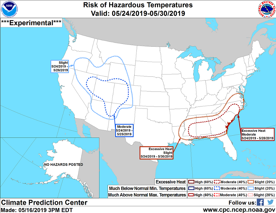
On the bright side it won't be too hot! We'll be in the 80s through Memorial day weekend which for May is nothing unusual for us with chances of rain.

Now in the southeast US is a different story. They will be well into the 90s which for them, in May, is very hot underneath an unseasonably strong heat dome.

Image
2 likes   
The above post and any post by Ntxw is NOT an official forecast and should not be used as such. It is just the opinion of the poster and may or may not be backed by sound meteorological data. It is NOT endorsed by any professional institution including Storm2k. For official information, please refer to NWS products.

  Help support Storm2K!
Help Support Storm2K

User avatar
cheezyWXguy
Category 5
Category 5
Posts: 6108
Joined: Mon Feb 13, 2006 12:29 am
Location: Dallas, TX

Re: Texas Spring 2019

#1478 Postby cheezyWXguy » Fri May 17, 2019 9:59 am

bubba hotep wrote:
cheezyWXguy wrote:I see potential in an afternoon round of severe storms in dfw, even if the line passss through. Nam 3k shows the initial line moving through, still fairly strong, at noon and by late afternoon, cape values are over 4000. It doesn’t show much development in this environment, but with that kind of atmospheric recovery, it’s hard to ignore the possibility. FWD NWS also acknowledges this:

We'll also have to monitor the potential for redevelopment late Saturday afternoon behind the morning round of storms. This will be highly conditional on trends earlier in the day, such as how much stratiform precipitation (if any) exists behind the morning line, as well as how much clearing occurs through the peak heating hours to destabilize locations immediately ahead of an eastward-moving dryline. Lingering synoptic-scale ascent should still be present in this area, but potential new development will have many mesoscale influences from prior thunderstorms. Should convection be able to initiate back to the west of I-35, it would pose a renewed severe threat in these areas heading into the late afternoon and evening hours.


A couple of the TX Tech 4k ensemble members fire a cell late off the dryline. The NCAR ensembles don't but they are slower with the main line of storms on Saturday.


Will be interesting to watch. The 12z 3k nam tries to fire off a second round, but it doesn’t maintain for very long in north tx
0 likes   

User avatar
cheezyWXguy
Category 5
Category 5
Posts: 6108
Joined: Mon Feb 13, 2006 12:29 am
Location: Dallas, TX

Re: Texas Spring 2019

#1479 Postby cheezyWXguy » Fri May 17, 2019 4:43 pm

Also of note, the HRRR is much further north with the placement of the mcs at 14z sat than the nam 3k, with the apex approaching okc. I’m hesitant to buy it, as the hrrr seems to be pretty poor run to run with storm placement, but if that plays out, I think the chances of afternoon storms capitalizing on an untapped atmosphere in the afternoon in ntx are quite a bit higher.
0 likes   

User avatar
bubba hotep
S2K Supporter
S2K Supporter
Posts: 5837
Joined: Wed Dec 28, 2016 1:00 am
Location: Collin County Texas

Re: Texas Spring 2019

#1480 Postby bubba hotep » Fri May 17, 2019 4:51 pm

Explosive development in SW Texas and cell is now Tor Warned

Image
1 likes   
Winter time post are almost exclusively focused on the DFW area.


Return to “USA & Caribbean Weather”

Who is online

Users browsing this forum: No registered users and 13 guests