Florida Weather
Moderator: S2k Moderators
Forum rules

The posts in this forum are NOT official forecast and should not be used as such. They are just the opinion of the poster and may or may not be backed by sound meteorological data. They are NOT endorsed by any professional institution or STORM2K.
Re: Florida Weather
Even if the above happens it's at best a run of the mill cool snap considering the calendar. Taking the freeze line to Gainesville and Cross City is hardly noteworthy in January. Just another round of good firepit weather. Speaking of which...that's on the docket pretty soon with cool nights and days expected around New Year's here. We need something to scour out our murky atmosphere and it is in sight. But significant cold...as of now...isn't in sight. Nevertheless this is the time of the year to keep checking in, especially when it's 50 below in AK.
0 likes

Re: Florida Weather
TheStormExpert wrote:The problem is the CMC is just as crazy with cold weather for Florida as it is with blowing up everything in the Atlantic come hurricane season. Don’t believe it until the Euro comes onboard in a reasonable timeframe or for several runs.
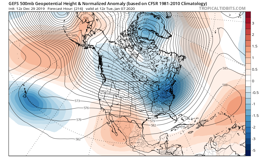
A little bit crazy, yes. However I've noticed the GEM displaying a curious similarity to EURO forecast models. Speaking of the EURO, it IS now in line with the GFS's forecast for 240 hr's. The GFS (and now the EURO) is showing a nice sharp 500mb trough dropping down to the Gulf coast at that time. GFS has been advertising this 2nd cold punch to occur around the 6th/7th. Payclone makes a good point however. This will be cold air for sure but it's not looking like anything anomalous. Probably low to mid 30's for a good cross section of Central Fl roughly from Tampa east to Melbourne. This far out I'd guess upper 30's for far southern Everglades and inland S. Florida. Lot's of time to see if this continues to look like it'll verify though
1 likes
Andy D
(For official information, please refer to the NHC and NWS products.)
(For official information, please refer to the NHC and NWS products.)


-
gatorcane

- S2K Supporter

- Posts: 23708
- Age: 48
- Joined: Sun Mar 13, 2005 3:54 pm
- Location: Boca Raton, FL
Re: Florida Weather
chaser1 wrote:TheStormExpert wrote:The problem is the CMC is just as crazy with cold weather for Florida as it is with blowing up everything in the Atlantic come hurricane season. Don’t believe it until the Euro comes onboard in a reasonable timeframe or for several runs.
A little bit crazy, yes. However I've noticed the GEM displaying a curious similarity to EURO forecast models. Speaking of the EURO, it IS now in line with the GFS's forecast for 240 hr's. The GFS (and now the EURO) is showing a nice sharp 500mb trough dropping down to the Gulf coast at that time. GFS has been advertising this 2nd cold punch to occur around the 6th/7th. Payclone makes a good point however. This will be cold air for sure but it's not looking like anything anomalous. Probably low to mid 30's for a good cross section of Central Fl roughly from Tampa east to Melbourne. This far out I'd guess upper 30's for far southern Everglades and inland S. Florida. Lot's of time to see if this continues to look like it'll verify though
Euro completely flipped on the 12Z and shows a deep trough heading for the Eastern CONUS similar to the GFS which also flipped on the 12Z. Needless to say there is some uncertainty as far as the extent of the cold but I would lean towards below normal temps and cold penetrating Florida starting the first week of January.
0 likes

Re: Florida Weather
Both the GEFS & EPS show a Greenland Block non existent through at least the next
10 days, without a -NAO any Arctic air that makes it down to the US its core will stay to the north of FL and go straight out to sea. You need that Greenland block for the core to come straight to the south. Not unless we see one heck of an Arctic High to come down to the US and give central FL a freeze even with a +NAO like it did in Jan ‘18.
Both the EPS & GEFS are trending colder for the eastern US, but keeping the coldest anomalies well to the north of us. The NWS forecasts will probably start trending that way in its 6-10 range.
0 likes
-
northjaxpro

- S2K Supporter
- Posts: 8900
- Joined: Mon Sep 27, 2010 11:21 am
- Location: Jacksonville, FL
Re: Florida Weather
NDG wrote:Both the GEFS & EPS show a Greenland Block non existent through at least the next
10 days, without a -NAO any Arctic air that makes it down to the US its core will stay to the north of FL and go straight out to sea. You need that Greenland block for the core to come straight to the south. Not unless we see one heck of an Arctic High to come down to the US and give central FL a freeze even with a +NAO like it did in Jan ‘18.
Both the EPS & GEFS are trending colder for the eastern US, but keeping the coldest anomalies well to the north of us. The NWS forecasts will probably start trending that way in its 6-10 range.
https://i.imgur.com/ZawON2u.jpg
I could not have summarized this any better. I expected significantly colder, but not extreme, anomalous cold because of the -PNA and +NAO teleconnections indices we are in at this time. NDG pointed out and something I noticed in the 500 mb 10-day analysis, we are finally seeing signs of The Greenland Blocking pattern. This is what is usually present when a -NAO is in existence. But at the current time we are still in a + NAO. However, let's see now if it changes the deeper we get into January.
In my previous posts, I stated that eventually the pendulum would gradually turm the way of the GFS and its ensembles. The questions, HOW COLD and the WHEN. I initially thought the Jan 8-10 period would be when we would potentially see a significant cool down across the Eastern CONUS and into North Florida peninsula for potential freezes. This could come a bit sooner or later.
B
Also, last night's 00Z GFS did show a 1053 mb Arctic High dropping out of Manitoba on January 8. The 06Z run earlier this morning backed off from showing that this cycle, but it is something to watch for in future runs.
0 likes
NEVER, EVER SAY NEVER in the tropics and weather in general, and most importantly, with life itself!!
________________________________________________________________________________________
Fay 2008 Beryl 2012 Debby 2012 Colin 2016 Hermine 2016 Julia 2016 Matthew 2016 Irma 2017 Dorian 2019
________________________________________________________________________________________
Fay 2008 Beryl 2012 Debby 2012 Colin 2016 Hermine 2016 Julia 2016 Matthew 2016 Irma 2017 Dorian 2019
Re: Florida Weather
Cooldown...yes. Cold blast...no. At least none in sight yet. Looking forward to the cool front that is marching toward us to scour out our greasy (by winter standards) low levels.
0 likes
-
SFLcane

- S2K Supporter
- Posts: 10281
- Age: 48
- Joined: Sat Jun 05, 2010 1:44 pm
- Location: Lake Worth Florida
Re: Florida Weather
As this decade ends let’s hope the luck for SFL dade broward county’s continues in terms of major hurricane impacts we have been walking a tight rope. Let’s keep it going in 2020 wishing everyone the best.
Adrian
Adrian
0 likes
Re: Florida Weather
Interesting analog if we go by the AO index, which I looked back into, it was a warm January for Central FL both in '93 & '89 but it was a La Nina winter unlike this one.
https://twitter.com/WorldClimateSvc/status/1211681837858332672
https://twitter.com/WorldClimateSvc/status/1211681837858332672
0 likes
-
gatorcane
- S2K Supporter
- Posts: 23708
- Age: 48
- Joined: Sun Mar 13, 2005 3:54 pm
- Location: Boca Raton, FL
Re: Florida Weather
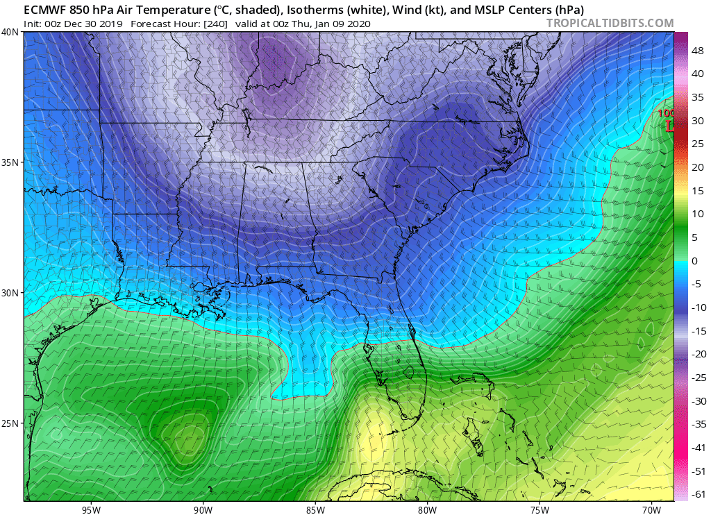
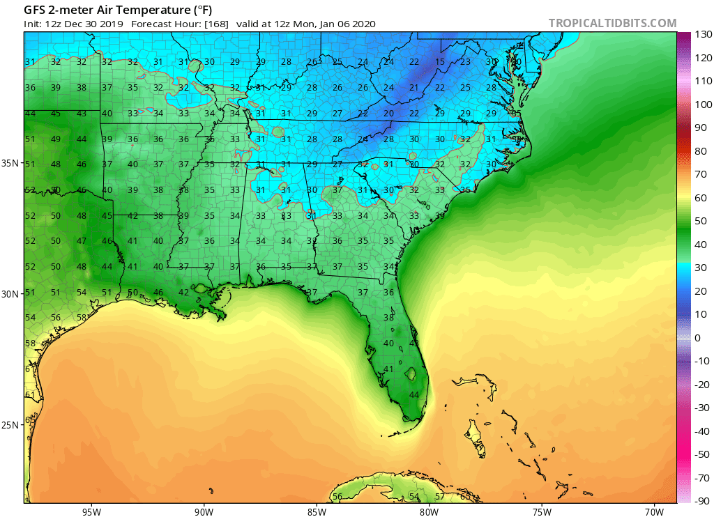
The Euro is showing some pretty cold air invading the state around a week from now. That would probably translate to widespread lower 40s to mid 40s across Central Florida with some 30s as well. 
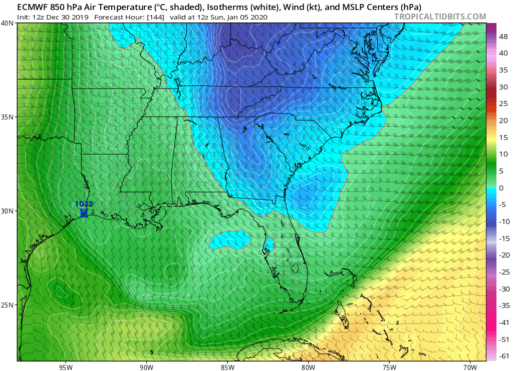
The GFS is also cold, 44F in Miami.
The GFS is also cold, 44F in Miami.
0 likes


Re: Florida Weather
As long as the NAO stays positive those temperatures probably will be a lot warmer or not materialize.
0 likes
Re: Florida Weather
We need some verification standards on here for long range modeling. Actually this thread serves as a multi year archive of models overestimating long range cold. We've got cooler weather incoming, followed by a rebound and then another cooldown a week from now. But nothing seems out of the ordinary or crazy. In fact, it probably averages out to be a touch above normal. Low to mid 40's in central fl for lows when normal is 50 isn't noteworthy or remotely unusual. But the last 2 mornings with lows in the 70's at Tampa...now that is noteworthy. I'm looking forward to the cooldown and some seasonal low dewpoint air. BTW it really helps to go back a couple weeks in this thread and see how model progs then verified. To that end, let's remember the GFS snowstorm for January 4. It looks like most of the "snow" area is expecting highs of 65-70. Oops. So far, we're having a pretty decent Winter season as we alternate between warm and cool shots with ample rain and no harsh cold. Pollen season (pines) starts in mid January and the days are now getting longer.
2 likes
Re: Florida Weather
BTW for those cool weather fans...today's 6-10 day outlooks shows a light shade of below normal for the first time in several weeks. We've got some chilly hoodie firepit weather on the docket which will be a notable change.
0 likes
Re: Florida Weather
Yep, the Euro and GFS now agree on a good cool down for the Peninsula from Saturday into Monday, temps will be a good 10 degrees below average but a far cry from the 20s for cent FL the GFS had for early next week a few days ago.
At this time something to keep in mind is that the EPS is not as cold as the latest Operational Euro run for Monday's morning lows.
At this time something to keep in mind is that the EPS is not as cold as the latest Operational Euro run for Monday's morning lows.
0 likes
-
gatorcane
- S2K Supporter
- Posts: 23708
- Age: 48
- Joined: Sun Mar 13, 2005 3:54 pm
- Location: Boca Raton, FL
Re: Florida Weather
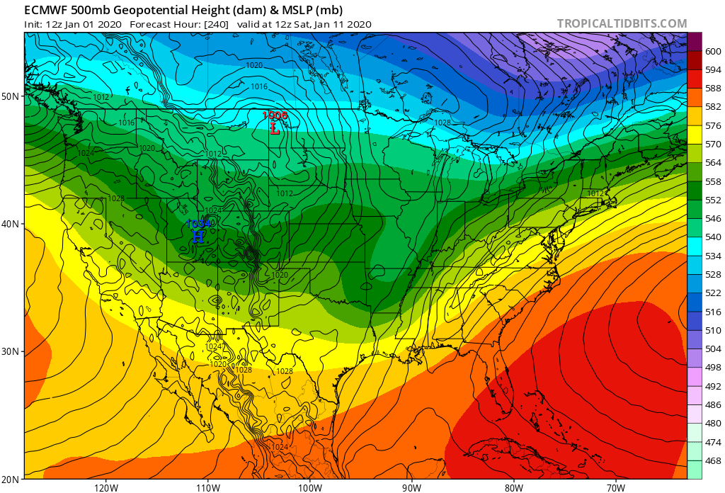
Looking in the long-range if this doesn’t scream “SE ridge” I don’t know what does, no cold air if this verifies. That said looks well below normal in the medium to short-range:
0 likes
Re: Florida Weather
Hot off the press CPC 8-14 day... Torch watch for eastern US...epicenter...drumroll please....
Florida
This probably surprises no one. Let's see how this evolves. Unlike cold, long range torches tend to verify. Get out your flip flops
Florida
This probably surprises no one. Let's see how this evolves. Unlike cold, long range torches tend to verify. Get out your flip flops
0 likes
Re: Florida Weather
Happy New Year and hoping that the torch will not last that long and and a couple of weeks of below normal temps. Unfortunately it seems like we are stuck with a positive NAO.
0 likes
Re: Florida Weather
That ridge looks tough. Sad to say, but with regard to the chances for significant and/or prolonged chill for extreme S Florida and the Keys, the fat lady is warming up. If that massive subtropical high is sitting in that position at 8-14 days, our window is just about closed......and as has been stated, those torch ridges tend to verify. This weekend's cold hit should feel pretty nice, but I wouldn't call it either prolonged or significant.
0 likes
Return to “USA & Caribbean Weather”
Who is online
Users browsing this forum: Iceresistance and 63 guests