

TC Bertha
Moderator: S2k Moderators
Re: Tropical Storm Bertha in Central Atlantic
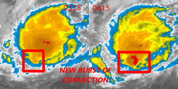
New image from 30 mins ago... convection on the S now
0 likes
-
JonathanBelles
- Professional-Met

- Posts: 11430
- Age: 35
- Joined: Sat Dec 24, 2005 9:00 pm
- Location: School: Florida State University (Tallahassee, FL) Home: St. Petersburg, Florida
- Contact:
Re: Tropical Storm Bertha in Central Atlantic
Advisory 070608a
Tropical Storm Bertha continues organizing and quickly moving west.
No change in track, no graphic at this time. This advisory is exclusively on Bertha.
Central Atlantic....Tropical Storm Bertha. Tropical storm west is slowing organizing as it moves westward at about 18kts. I currently estimate Bertha to have winds of about 45-50kts (55mph), even though the NHC has it at 45kts (50mph). SST's and OHC has improved, and shear is still low. Microwave has shown that convection is wrapping around the system. over night I expect convection to continue to pop.
I think that a Hurricane is definitely possible in about 3 days or possibly less. Shear is not as bad as once forecast. I expect for the next few hours-day that Bertha should be south of the forecast track. The track is about the same as before, and is still as uncertain as before. Landfall is not imminent anywhere at this point, but everyone from the northern and eastern Caribbean to the Carolinas should be watching this. Prep you kits for a just in case.
Fact789-Jonathan
0 likes

-
Ed Mahmoud
Re: Re:
Aric Dunn wrote:Derek Ortt wrote:the microwave from the afternoon was just a bit more impressive than the latest one.
A partial eye-type feature was forming this afternoon. Since then, the feature has deteriorated
hardly .. the convection is deeper. and wraping around..
I think he was talking about microwave imagery, and, as a degreed met, 'hardly' seems a bit strong to dismiss his analysis. Maybe I'm biased, since he is one of two pro-mets who regularly comments on sports. But I don't think so.
0 likes

Re: Tropical Storm Bertha in Central Atlantic
gotoman38 wrote:New image from 30 mins ago... convection on the S now
my guess that is where the LLC is currently dispaced to the South moving west with the low level flow.
0 likes
-
Ed Mahmoud
Re: Tropical Storm Bertha in Central Atlantic
ROCK wrote:http://cimss.ssec.wisc.edu/tropic/real-time/atlantic/winds/wg8dlm2.html
steering...
Good thing that isn't static, or Corpus Christi would be in trouble...
0 likes
Re: Tropical Storm Bertha in Central Atlantic
Yeah ED, I agree with you on that. I have seen storms LLC's out race their convection. She is clipping along at a rapid pace with some light southernly shear...
0 likes
Re: Tropical Storm Bertha in Central Atlantic
Ed Mahmoud wrote:ROCK wrote:http://cimss.ssec.wisc.edu/tropic/real-time/atlantic/winds/wg8dlm2.html
steering...
Good thing that isn't static, or Corpus Christi would be in trouble...
agreed...
0 likes
Re: Tropical Storm Bertha in Central Atlantic
ROCK wrote:Ed Mahmoud wrote:ROCK wrote:http://cimss.ssec.wisc.edu/tropic/real-time/atlantic/winds/wg8dlm2.html
steering...
Good thing that isn't static, or Corpus Christi would be in trouble...
agreed...
Goodness!

0 likes
-
Matt-hurricanewatcher
Re: Tropical Storm Bertha in Central Atlantic
It appears that the southwestly shear has returned, with the cloud tops being shear to the north of the LLC once again. That small burst was right over the LLC; at least it would appear so. I would place the LLC near 16.9/42.1 and moving just north of west.
0 likes


-
cheezyWXguy

- Category 5

- Posts: 6281
- Joined: Mon Feb 13, 2006 12:29 am
- Location: Dallas, TX
Re: Tropical Storm Bertha in Central Atlantic
Matt-hurricanewatcher wrote:It appears that the southwestly shear has returned, with the cloud tops being shear to the north of the LLC once again. That small burst was right over the LLC; at least it would appear so. I would place the LLC near 16.9/42.1 and moving just north of west.
eh, based on the microwave imagery, it looks like the center is more ENE of that...although the storm isnt exactly in great shape right now. However it is improving, keeping convection constant, and it is likely stronger than it was earlier today.
0 likes
Re: Tropical Storm Bertha in Central Atlantic
Matt-hurricanewatcher wrote:It appears that the southwestly shear has returned, with the cloud tops being shear to the north of the LLC once again. That small burst was right over the LLC; at least it would appear so. I would place the LLC near 16.9/42.1 and moving just north of west.
Yeah Matt, thats where I would put the center, and moving barely N of due west if not west....
also she might barely miss her next forecast point to the south...
0 likes
-
Matt-hurricanewatcher
Re: Tropical Storm Bertha in Central Atlantic
cheezyWXguy wrote:Matt-hurricanewatcher wrote:It appears that the southwestly shear has returned, with the cloud tops being shear to the north of the LLC once again. That small burst was right over the LLC; at least it would appear so. I would place the LLC near 16.9/42.1 and moving just north of west.
eh, based on the microwave imagery, it looks like the center is more ENE of that...although the storm isnt exactly in great shape right now. However it is improving, keeping convection constant, and it is likely stronger than it was earlier today.
I believe the LLC has moved near due westward for the last 4-5 hours. In with the burst of the convection, it may of even slided "slightly" to the south as that burst formed more or less south of center. Kind of like the burst to the north of the system been moving it more and more northward.
http://www.nrlmry.navy.mil/tc_pages/tc0 ... atest.html
0 likes


Re: Tropical Storm Bertha in Central Atlantic
17.0N 42.1W is where I see it, but we're just guessing here I believe.

0 likes
Re: Tropical Storm Bertha in Central Atlantic
gotoman38 wrote:17.0N 42.1W is where I see it, but we're just guessing here I believe.
yeah that seems to be the consensus attm......
0 likes
Who is online
Users browsing this forum: No registered users and 56 guests