

Texas Winter 2018-2019
Moderator: S2k Moderators
Forum rules
 The posts in this forum are NOT official forecast and should not be used as such. They are just the opinion of the poster and may or may not be backed by sound meteorological data. They are NOT endorsed by any professional institution or STORM2K.

The posts in this forum are NOT official forecast and should not be used as such. They are just the opinion of the poster and may or may not be backed by sound meteorological data. They are NOT endorsed by any professional institution or STORM2K.
Re: Texas Winter 2018-2019
Reed Timmer will be chasing initially, near Brownwood later today. 

0 likes
-
bubba hotep

- S2K Supporter

- Posts: 6012
- Joined: Wed Dec 28, 2016 1:00 am
- Location: Collin County Texas
Re: Texas Winter 2018-2019
bubba hotep wrote:The EPS propagates the MJO faster and at a lower amp than the GEFS.
https://i.ibb.co/vw0WMH2/ECMF-phase-MANOM-51m-small.gif
In +ENSO January the analogs show a pretty big difference between high amp P6 and lower amp P8
P6 high amp Surface Temp Anomalies
https://i.ibb.co/mSsHwvc/Jan-ENMJOphase6gt12m-T.gif
vs P8 lower amp Surface Temp Anomalies
https://i.ibb.co/2yfN91y/Jan-ENMJOphase8all2m-T.gif
Things are no clearer today as both the GEFS and Euro EPS stick to their guns on the MJO. Interestingly, the EPS shows more spread on the warm side of things in early January. Both the GEFS and EPS show Texas eventually ending up under dry NW flow as we head into January with most of the cold air shunted off to the East.
1 likes
Winter time post are almost exclusively focused on the DFW area.
-
Haris

- Category 5

- Posts: 1814
- Joined: Mon Nov 27, 2017 8:19 pm
- Location: ( Bee Cave) West Austin, Texas
Re: Texas Winter 2018-2019

[
Haven’t seen such a large enhanced risk area since last spring. Latest update
2 likes
Weather geek and a storm spotter in West Austin. Not a degreed meteorologist. Big snow fan. Love rain and cold! Despise heat!


Re: Texas Winter 2018-2019
4 likes
The above post and any post by Ntxw is NOT an official forecast and should not be used as such. It is just the opinion of the poster and may or may not be backed by sound meteorological data. It is NOT endorsed by any professional institution including Storm2k. For official information, please refer to NWS products.
Help support Storm2K!
-
bubba hotep
- S2K Supporter
- Posts: 6012
- Joined: Wed Dec 28, 2016 1:00 am
- Location: Collin County Texas
Re: Texas Winter 2018-2019
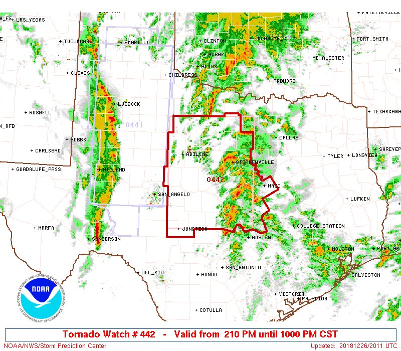
1st watch of the day coming shortly

Mesoscale Discussion 1725
NWS Storm Prediction Center Norman OK
1228 PM CST Wed Dec 26 2018
Areas affected...Parts of Central and Northwest Texas
Concerning...Severe potential...Tornado Watch likely
Valid 261828Z - 262030Z
Probability of Watch Issuance...95 percent
SUMMARY...Tornado threat will increase across parts of central and
northwest TX as the afternoon evolves.
DISCUSSION...Sustained low-level warm advection appears mostly
responsible for gradual increase in deep convection from the
northern Hill Country into northwest TX. LLJ is forecast to
strengthen across northwest TX into southwest OK into late afternoon
and a corridor of scattered strong thunderstorms may ultimately
evolve along this axis over the next 2-4 hours as the source region
for updrafts gradually lowers into the boundary layer. Latest
observations suggest near-surfaced based parcels are already buoyant
and temperatures in the upper 60s to near 70F will result in no
CINH. Latest thinking is scattered supercells should evolve ahead of
maturing squall line and given the strong shear the tornado threat
should increase. Tornado watch will likely be issued by 20z to
account for this threat.
..Darrow/Thompson.. 12/26/2018
0 likes
Winter time post are almost exclusively focused on the DFW area.
-
bubba hotep
- S2K Supporter
- Posts: 6012
- Joined: Wed Dec 28, 2016 1:00 am
- Location: Collin County Texas
Re: Texas Winter 2018-2019
For West Texas

0 likes
Winter time post are almost exclusively focused on the DFW area.
-
wxman57

- Moderator-Pro Met

- Posts: 23170
- Age: 68
- Joined: Sat Jun 21, 2003 8:06 pm
- Location: Houston, TX (southwest)
Re: Texas Winter 2018-2019
Goodbye massive upper-level low over South Texas on January 4th (as per previous ECMWF runs). 12Z EC run says "never mind".

1 likes

Re: Texas Winter 2018-2019
Well I see the models are back to being boring again. What a surprise 
1 likes

Re: Texas Winter 2018-2019
wxman57 wrote:Goodbye massive upper-level low over South Texas on January 4th (as per previous ECMWF runs). 12Z EC run says "never mind".
http://wxman57.com/images/ECLoop.gif
Still 9 + days out! Remember never believe anything unless it's within a few day's and even then it's not always reliable.
0 likes
Re: Texas Winter 2018-2019
Lot's of thunder and some lightning here In big D. Haven't seen or heard that in a long time.
2 likes
-
wxman57
- Moderator-Pro Met
- Posts: 23170
- Age: 68
- Joined: Sat Jun 21, 2003 8:06 pm
- Location: Houston, TX (southwest)
Re: Texas Winter 2018-2019
EnnisTx wrote:wxman57 wrote:Goodbye massive upper-level low over South Texas on January 4th (as per previous ECMWF runs). 12Z EC run says "never mind".
http://wxman57.com/images/ECLoop.gif
Still 9 + days out! Remember never believe anything unless it's within a few day's and even then it's not always reliable.
That was my point.
0 likes
-
Brent
- S2K Supporter
- Posts: 38716
- Age: 37
- Joined: Sun May 16, 2004 10:30 pm
- Location: Tulsa Oklahoma
- Contact:
Re: Texas Winter 2018-2019
Cpv17 wrote:Well I see the models are back to being boring again. What a surprise
some things are so predictable

1 likes
#neversummer
Re: Texas Winter 2018-2019
wxman57 wrote:EnnisTx wrote:wxman57 wrote:Goodbye massive upper-level low over South Texas on January 4th (as per previous ECMWF runs). 12Z EC run says "never mind".
http://wxman57.com/images/ECLoop.gif
Still 9 + days out! Remember never believe anything unless it's within a few day's and even then it's not always reliable.
That was my point.
Actually, I was looking for one of your quotes saying the same thing, so I knew what your point was..
0 likes
Re: Texas Winter 2018-2019
Should be looking at a Tornado Watch from the DFW Metro to the South and West before long.
1 likes
-
missygirl810

- Tropical Storm

- Posts: 154
- Joined: Fri Oct 27, 2017 3:07 pm
- Location: Celeste TX Hunt County Fannin Co line
Re: Texas Winter 2018-2019
Brent wrote:quite a lightning show with this initial round
How many rounds will there be?
0 likes
-
Brent
- S2K Supporter
- Posts: 38716
- Age: 37
- Joined: Sun May 16, 2004 10:30 pm
- Location: Tulsa Oklahoma
- Contact:
Re: Texas Winter 2018-2019
missygirl810 wrote:Brent wrote:quite a lightning show with this initial round
How many rounds will there be?
scattered storms on and off through early evening then likely a big line towards late evening/midnight which would end the threat
3 likes
#neversummer
-
bubba hotep
- S2K Supporter
- Posts: 6012
- Joined: Wed Dec 28, 2016 1:00 am
- Location: Collin County Texas

Re: Texas Winter 2018-2019
I hope everyone had a wonderful Christmas day. Been nice weather today though definitely monitoring conditions as we head into the evening. Stay safe!
1 likes
Resident Rain Miser
I am a weather hobbyist living 3.5 miles south of Downtown Austin and in no way or fashion should anything I say concerning forecasts be taken seriously. Please check your local NWS for accurate weather forecasting and conditions.
I am a weather hobbyist living 3.5 miles south of Downtown Austin and in no way or fashion should anything I say concerning forecasts be taken seriously. Please check your local NWS for accurate weather forecasting and conditions.
Who is online
Users browsing this forum: cheezyWXguy and 85 guests