HURRICANE JOAQUIN FORECAST/ADVISORY NUMBER 14
NWS NATIONAL HURRICANE CENTER MIAMI FL AL112015
0900 UTC THU OCT 01 2015
CHANGES IN WATCHES AND WARNINGS WITH THIS ADVISORY...
NONE.
SUMMARY OF WATCHES AND WARNINGS IN EFFECT...
A HURRICANE WARNING IS IN EFFECT FOR...
* CENTRAL BAHAMAS
* NORTHWESTERN BAHAMAS INCLUDING THE ABACOS...BERRY ISLANDS...
ELEUTHERA...GRAND BAHAMA ISLAND...AND NEW PROVIDENCE
A HURRICANE WATCH IS IN EFFECT FOR...
* BIMINI
* ANDROS ISLAND
A TROPICAL STORM WARNING IS IN EFFECT FOR...
* SOUTHEASTERN BAHAMAS EXCLUDING THE TURKS AND CAICOS ISLANDS
* ANDROS ISLAND
A HURRICANE WARNING MEANS THAT HURRICANE CONDITIONS ARE EXPECTED
SOMEWHERE WITHIN THE WARNING AREA. PREPARATIONS TO PROTECT LIFE AND
PROPERTY SHOULD BE RUSHED TO COMPLETION IN THE NORTHWESTERN
BAHAMAS.
A HURRICANE WATCH MEANS THAT HURRICANE CONDITIONS ARE POSSIBLE
WITHIN THE WATCH AREA.
A TROPICAL STORM WARNING MEANS THAT TROPICAL STORM CONDITIONS ARE
EXPECTED SOMEWHERE WITHIN THE WARNING AREA.
HURRICANE CENTER LOCATED NEAR 23.4N 73.7W AT 01/0900Z
POSITION ACCURATE WITHIN 25 NM
PRESENT MOVEMENT TOWARD THE WEST-SOUTHWEST OR 240 DEGREES AT 4 KT
ESTIMATED MINIMUM CENTRAL PRESSURE 948 MB
MAX SUSTAINED WINDS 105 KT WITH GUSTS TO 130 KT.
64 KT....... 25NE 30SE 20SW 20NW.
50 KT....... 40NE 60SE 30SW 40NW.
34 KT.......100NE 120SE 100SW 80NW.
12 FT SEAS..220NE 180SE 100SW 180NW.
WINDS AND SEAS VARY GREATLY IN EACH QUADRANT. RADII IN NAUTICAL
MILES ARE THE LARGEST RADII EXPECTED ANYWHERE IN THAT QUADRANT.
REPEAT...CENTER LOCATED NEAR 23.4N 73.7W AT 01/0900Z
AT 01/0600Z CENTER WAS LOCATED NEAR 23.5N 73.5W
FORECAST VALID 01/1800Z 23.1N 74.2W
MAX WIND 115 KT...GUSTS 140 KT.
64 KT... 35NE 40SE 20SW 20NW.
50 KT... 60NE 70SE 40SW 60NW.
34 KT...120NE 130SE 100SW 90NW.
FORECAST VALID 02/0600Z 23.4N 74.8W
MAX WIND 120 KT...GUSTS 145 KT.
64 KT... 40NE 40SE 30SW 30NW.
50 KT... 70NE 80SE 50SW 50NW.
34 KT...140NE 150SE 100SW 100NW.
FORECAST VALID 02/1800Z 25.0N 74.8W
MAX WIND 120 KT...GUSTS 145 KT.
64 KT... 50NE 50SE 40SW 40NW.
50 KT... 70NE 80SE 60SW 60NW.
34 KT...150NE 150SE 100SW 120NW.
FORECAST VALID 03/0600Z 26.8N 74.1W
MAX WIND 110 KT...GUSTS 135 KT.
50 KT... 80NE 90SE 60SW 70NW.
34 KT...180NE 190SE 120SW 140NW.
FORECAST VALID 04/0600Z 32.5N 74.0W
MAX WIND 95 KT...GUSTS 115 KT.
50 KT... 90NE 90SE 60SW 70NW.
34 KT...230NE 190SE 100SW 150NW.
EXTENDED OUTLOOK. NOTE...ERRORS FOR TRACK HAVE AVERAGED NEAR 150 NM
ON DAY 4 AND 200 NM ON DAY 5...AND FOR INTENSITY NEAR 15 KT EACH DAY
OUTLOOK VALID 05/0600Z 36.0N 74.5W
MAX WIND 80 KT...GUSTS 100 KT.
OUTLOOK VALID 06/0600Z 39.0N 74.0W
MAX WIND 60 KT...GUSTS 75 KT.
REQUEST FOR 3 HOURLY SHIP REPORTS WITHIN 300 MILES OF 23.4N 73.7W
NEXT ADVISORY AT 01/1500Z
ATL: JOAQUIN - Post-Tropical - Discussion
Moderator: S2k Moderators


-
Kingarabian

- S2K Supporter

- Posts: 16351
- Joined: Sat Aug 08, 2009 3:06 am
- Location: Honolulu, Hawaii
000
WTNT41 KNHC 010849
TCDAT1
HURRICANE JOAQUIN DISCUSSION NUMBER 14
NWS NATIONAL HURRICANE CENTER MIAMI FL AL112015
500 AM EDT THU OCT 01 2015
Data from the last aircraft mission indicated the Joaquin had
strengthened a little more, and the intensity of 105 kt is supported
by flight-level, SFMR, and dropsonde data from the plane. The
central pressure of 948 mb is based on a dropsonde that measured 950
mb with 20 kt of wind. The satellite presentation of the hurricane
continues to gradually improve, with cold tops expanding near and
west of the center, although the eye is not yet apparent in infrared
imagery. Another hurricane hunter aircraft will be investigating
Joaquin later this morning.
Joaquin is expected to intensify a little more in the next 12 to 24
hours while over very warm waters and with decreasing vertical
shear. After that time, there could be some fluctuations in
intensity due to eyewall replacement cycles and perhaps some
upwelling of cold waters due to the slow motion of the hurricane.
After 48 hours, cooler SSTs and increasing shear should result in
gradual weakening as Joaquin moves northward. The new NHC intensity
forecast is similar to the previous one and close to the HWRF
through 24 hours. After that time, the NHC prediction is above the
intensity consensus since the official forecast keeps the cyclone
offshore, while the remainder of the intensity guidance shows
weakening due to decay over land.
The initial motion of the hurricane is still toward the southwest
or 230/04 under the influence of a narrow ridge to the north. A
slow motion with a bending of the track toward the west and then
the west-northwest is expected during the next 24 hours as the
ridge weakens. During this time the NHC track has been adjusted
southward following the latest trend in the guidance. The slow
motion of Joaquin will mean a prolonged period of hurricane
conditions in portions of the central Bahamas, along with very heavy
rain and storm surge.
By 36 hours, Joaquin should begin to move faster toward the north as
it comes under the influence of a deep-layer trough that cuts off
over the southeastern United States. There have been big changes in
some of the track guidance overnight, perhaps due to data from the
synoptic surveillance mission flown by the NOAA G-IV jet for the 00Z
model cycle. In particular, the GFS and UKMET have shifted eastward
by several hundred miles in 3 to 4 days relative to their previous
solutions. Overall for this cycle there has been a spreading out of
the guidance envelope beyond 2 days, with a wide range of solutions
shown. The HWRF and GFDL are the fastest to bring Joaquin north out
of the Bahamas and still show a sharp westward turn taking the
cyclone inland over the Carolinas in 3 to 4 days. The GFS has
trended slower coming out of the Bahamas and now shows a track
toward Long Island and southern New England in 5 days, with the
UKMET farther offshore. The latest ECMWF is still the slowest and
farthest east with a track just west of Bermuda in 4 to 5 days.
Given the large shift in some of the guidance, the NHC track has
been adjusted just a little to the east and slower at days 3 through
5, and now lies on the left side of the multi-model consensus and
left of the GFS, UKMET and ECMWF solutions. Confidence remains very
low in the eventual track of Joaquin and any potential impacts for
the United States, and further adjustments to the NHC track may be
needed later today.
KEY MESSAGES:
1. Preparations to protect life and property in the central Bahamas
should be complete. The slow motion of Joaquin during the next 24
to 36 hours will bring a prolonged period of hurricane force winds,
storm surge, and very heavy rainfall to those islands.
2. Confidence in the details of the forecast after 72 hours remains
low, as there have been some large changes in the model guidance
overnight. The range of possible outcomes is still large, and
the possibility of a hurricane landfall in the Carolinas still
cannot be ruled out.
3. Efforts continue to provide the forecast models with as much
data as possible. The NOAA G-IV jet flew the first in a series of
missions in the storm environment last night, and these missions
will continue today. The National Weather Service also continues to
launch extra balloon soundings.
4. Because landfall, if it occurs, is still more than three days
away, it's too early to talk about specific wind, rain, or surge
impacts from Joaquin in the United States. Regardless of Joaquin's
track, strong onshore winds will create minor to moderate coastal
flooding along the coasts of the mid-Atlantic and northeastern
states through the weekend.
5. A hurricane watch for a portion of the U.S. coast could be
required as early as tonight.
6. Many portions of the eastern U.S. are currently experiencing
heavy rains and gusty winds associated with a frontal system. These
heavy rains are likely to continue for the next few days, even if
the center of Joaquin stays offshore. The resulting inland flood
potential could complicate preparations for Joaquin should it head
toward the coast, and even more substantial inland flooding is
possible if Joaquin later passes near or over these same areas.
FORECAST POSITIONS AND MAX WINDS
INIT 01/0900Z 23.4N 73.7W 105 KT 120 MPH
12H 01/1800Z 23.1N 74.2W 115 KT 130 MPH
24H 02/0600Z 23.4N 74.8W 120 KT 140 MPH
36H 02/1800Z 25.0N 74.8W 120 KT 140 MPH
48H 03/0600Z 26.8N 74.1W 110 KT 125 MPH
72H 04/0600Z 32.5N 74.0W 95 KT 110 MPH
96H 05/0600Z 36.0N 74.5W 80 KT 90 MPH
120H 06/0600Z 39.0N 74.0W 60 KT 70 MPH
$$
Forecaster Brennan
0 likes
RIP Kobe Bryant
-
ninel conde


-
tatertawt24
- Category 1

- Posts: 309
- Joined: Wed Oct 24, 2012 12:57 pm
Re: ATL: JOAQUIN - Hurricane - Discussion
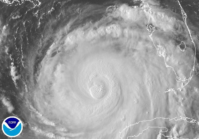
Reminds me of how Katrina looked before her eye finally cleared in the gulf. (Not to scare anybody or say it's going to be another Katrina; just saying it looks similar in terms of size and convection).
0 likes
Personal Forecast Disclaimer:
The posts in this forum are NOT official forecast and should not be used as such. They are just the opinion of the poster and may or may not be backed by sound meteorological data. They are NOT endorsed by any professional institution or storm2k.org. For official information, please refer to the NHC and NWS products.
The posts in this forum are NOT official forecast and should not be used as such. They are just the opinion of the poster and may or may not be backed by sound meteorological data. They are NOT endorsed by any professional institution or storm2k.org. For official information, please refer to the NHC and NWS products.

Re: ATL: JOAQUIN - Hurricane - Discussion
Weather Underground at San Salvador is showing 85 mph winds with gusts up to 110 mph right now. They are really taking a hit and it's been going on for quite a while now. Please stay safe.
0 likes
The following post is NOT an official forecast and should not be used as such. It is just the opinion of the poster and may or may not be backed by sound meteorological data. It is NOT endorsed by any professional institution including storm2k.org. For Official Information please refer to the NHC and NWS products.


Re: ATL: JOAQUIN - Hurricane - Discussion
Complete disaster in the Bahamas with Joaquin almost stationary now.
The 5 AM NHC advisory mentioned shear from a cut off low.
Looks like that future low is going to drop south over the Yucatan and provide lots of shear after 48 hours.
Still could pull a weakened storm into the US east coast if the low drops south far enough though.
http://www.ssd.noaa.gov/goes/east/natl/flash-wv.html
0 likes
Re: ATL: JOAQUIN - Hurricane - Discussion
The water vapor satellite this morning is very interesting. Like 3 waves of dry air coming from the northeast in that "shaft" between the two cloud streams with that large system in the Atlantic just west of the Azores (Which I think is what the Euro is picking up on), but at the same time looks like it could slip under everything. Anyone calling a model solution right at this point is jumping the gun until this thing starts moving. Those Central Bahamian islands are going to get an extended lashing.
--
Not an official forecast
--
Not an official forecast
0 likes
-
ninel conde


Re: ATL: JOAQUIN - Hurricane - Discussion

Beautiful satellite image this morning from Joaquin, wouldn't want to be in the path of this right now. The presentation looks impressive.
0 likes
-
Chris_in_Tampa
- Category 5

- Posts: 5101
- Age: 42
- Joined: Thu Jun 21, 2007 11:06 pm
- Location: Tampa, Florida, USA
- Contact:


-
tolakram
- Admin

- Posts: 20180
- Age: 62
- Joined: Sun Aug 27, 2006 8:23 pm
- Location: Florence, KY (name is Mark)
Re: ATL: JOAQUIN - Hurricane - Discussion
0 likes
M a r k
- - - - -
Join us in chat: Storm2K Chatroom Invite. Android and IOS apps also available.
The posts in this forum are NOT official forecasts and should not be used as such. Posts are NOT endorsed by any professional institution or STORM2K.org. For official information and forecasts, please refer to NHC and NWS products.
Who is online
Users browsing this forum: No registered users and 30 guests