
Now to wait for the 12z GFS. The previous NWS discussion mentioned 20" of snow in the foothills of Larimer county.
The storm will be big, as the magnitude of the storm remains consistant. It's all about location now...
Denver LACK OF snow/winter thread
Moderator: S2k Moderators
Forum rules
 The posts in this forum are NOT official forecast and should not be used as such. They are just the opinion of the poster and may or may not be backed by sound meteorological data. They are NOT endorsed by any professional institution or STORM2K.

The posts in this forum are NOT official forecast and should not be used as such. They are just the opinion of the poster and may or may not be backed by sound meteorological data. They are NOT endorsed by any professional institution or STORM2K.


Re: Denver LACK OF snow/winter thread
Winter storm cancel. I am over this. 0z now pretty much showing very little precip...like .25 inch in the metro area. This is depressing.
0 likes

Re: Denver LACK OF snow/winter thread
Denver is a desert....or at least it's heading in that direction. If you like a lot of snow, Denver isn't the city to be living in. That 60" annual snowfall average is VERY misleading. There's the occasion early and late snowfall....and the very occasional "big snow". Otherwise, I really don't see a lot of the white stuff. Winters here are usually a piece of cake. Last 10 year snowfall average is about 44". Not a big deal.
0 likes
Re: Denver LACK OF snow/winter thread
No major storm on the horizon, but I like the following statement from the NWS.
AT LEAST THE PATTERN FOR THE NEXT WEEK ISN`T
DOMINATED BY THE USUAL UPPER RIDGE.
GFS has a lot of little shots of moisture over the next 2 weeks. I'll take all we can get.
AT LEAST THE PATTERN FOR THE NEXT WEEK ISN`T
DOMINATED BY THE USUAL UPPER RIDGE.
GFS has a lot of little shots of moisture over the next 2 weeks. I'll take all we can get.
0 likes


Re: Denver LACK OF snow/winter thread
just a col rain fell last night here in downtown and it looked like more than a spinkle had fallen...although I was asleep through it. The only thing really eventful about that was that I think it was the first time this year that rain as opposed to snow fell. Either way it smells nice outside.
0 likes
Re: Denver LACK OF snow/winter thread
This is definately looking more hopeful than this last storm. We apparently have fairly good agreement between all model camps that this one will give us at least some upslope....
0z Nam tonight showing 1.25-1.5 inches of qpf from late thursday into Friday morning...which looks to be all snow, so maybe 10-15 inches...with the palmer divide doing very well, and areas to the NW doing a little worse. ALso appears that despite all the wonderful QPF, it will be a quick shot, as the storm is forecast to push into OK before KA, which takes the upslope away faster. Either way anything will be nice. If this could somehow by some miracle move a little slower I would be happy, but based on NAM through 84 hours...the party appears to be ending soon after 12z Friday for Denver
GFS at 0z not looking as good as NAM...but then GFS has been all over the map with these past couple systems and NAM got this last one right...so I am inclined to lean toward NAM, With obvious bias involved. The 0z GFS is just a hair too far south to give Denver much. In fact by 06z Friday GFS has the storm center over the red river valley(near or south Childress, TX, while at the same time NAM is still back in North central NM), Now if you remember...90 hours out from this past storm...GFS gave us the teaser blizzard senario because it was farther south than the other models...so perhaps, it is too far south again. Time will tell.
Also as a completely unscietific observation, I will say that in the past, it seems NAM (partly since it only goes out 84 hours while GFS has more time to give us entertainment runs) has fewer wild swings in the 84 hour period and seems to nail QPF better with the Denver upslope situations. however, NAM is slower, as the forecast discussion points out, then pretty much all the globals. Somehow I am guessing the answer will lie in the middle, and we will end up with an unremarkable 4-8 inch march storm here the Metro and nasty morning commute Friday.
0z Nam tonight showing 1.25-1.5 inches of qpf from late thursday into Friday morning...which looks to be all snow, so maybe 10-15 inches...with the palmer divide doing very well, and areas to the NW doing a little worse. ALso appears that despite all the wonderful QPF, it will be a quick shot, as the storm is forecast to push into OK before KA, which takes the upslope away faster. Either way anything will be nice. If this could somehow by some miracle move a little slower I would be happy, but based on NAM through 84 hours...the party appears to be ending soon after 12z Friday for Denver
GFS at 0z not looking as good as NAM...but then GFS has been all over the map with these past couple systems and NAM got this last one right...so I am inclined to lean toward NAM, With obvious bias involved.
Also as a completely unscietific observation, I will say that in the past, it seems NAM (partly since it only goes out 84 hours while GFS has more time to give us entertainment runs) has fewer wild swings in the 84 hour period and seems to nail QPF better with the Denver upslope situations. however, NAM is slower, as the forecast discussion points out, then pretty much all the globals. Somehow I am guessing the answer will lie in the middle, and we will end up with an unremarkable 4-8 inch march storm here the Metro and nasty morning commute Friday.
0 likes
Re: Denver LACK OF snow/winter thread
Just an update on the developing situation and what all the models and whatnot are doing. Actually not a whole lot has change since last night. latest 18z NAM this after generates QPF like crazy from Denver metro on down to OK panhandle with totals in the 1.5 -2.5 inch plus range and its still slower than GFS in ejecting the low eastward but they have sort of moved toward each other though. Actually all Globals have trended toward NAM. GFS has the low somewhere near SE OK/NE TX by 18z Friday, with NAM hanging it back toward western OK/TX panhandle still by then. GFS cuts off precip in Denver Metro by then while NAM keeps it going. 18 z Euro looks to be in the middle of the 2 although the maps arent as good. UKMET and Canadian somewhere in the same vicinity. Looks like no matter what happens Precip in Denver will likely have shut off by late afternoon Friday, and if other models are might more like mid morning. GFS still weaker overall with the system. GFS still points to a relatively unremarkable snow event for Denver with less than 5 inches....while NAM still points to much heavier snow fall senarios of snow up to 20 inches in the metro area and 2 ft in the palmer divide. NAM has been extrememly consistent with the front range QPF's from 1.5-2.0 inches range for the last 24 hours while GFS has come in with anywhere from .25 inches of QPF to .75. While they both seem consistent the locations of bullseye's of QPF on GFS seem to have varied a little more. I am still leaning toward NAM for the overall evolution of things and feel GFS will be too far south, but I suspect NAM could be overdone on QPF. HPC is painting a chance of 8+ inches on day 2 and day 3...suggesting to me that they arent buying the GFS PWF for this area. Denver is no longer in the 12+ inches of probablity on either day but I think that might have more to do with how they days were split up...as 8+8 equals 16 inches. Anywho...it should be interesting.
0 likes
Looking forward to it. I always like when our snow chances range from 2" to 2'. I like the following quote from the NWS.
LATEST INDICATIONS POINT TO A STEEP NE-TO-SW GRADIENT IN SNOW
ACCUMULATION ACROSS THE PLAINS...RANGING FROM A FEW INCHES UP NEAR
THE WY/NE BORDERS TO OVER A FOOT ON THE PALMER DIVIDE.
LATEST INDICATIONS POINT TO A STEEP NE-TO-SW GRADIENT IN SNOW
ACCUMULATION ACROSS THE PLAINS...RANGING FROM A FEW INCHES UP NEAR
THE WY/NE BORDERS TO OVER A FOOT ON THE PALMER DIVIDE.
0 likes
Re: Denver LACK OF snow/winter thread
Well, NAM and GFS have finally come together, unfortunately on the side of less precip for Denver. It should still be a decent little storm, and still possibly some of the highest storm totals for the year, but NAM no long has the bullseye of 20+ inches over the palmer divide. GFS is still sort of waffling but it has come in at 4-8 inch accums in the metro, while NAM is looking more like 6-10. hopefully the storm will end up a hair north of current progs, but its getting close to crunch time and these models arent likely to be too far off (although its happened plenty that they screw it up even in the 24 hour window). NAM and GFS just trying to come to the middle. Interestingly thuogh GFS produces WAY WAY less in SE CO than NAM does so still some kinks to work out. Sounds like that discrepency is probably still NAM keeping the system a little stronger. Suspect the metro will end up with a heavy snow advisory or "snow and blowing snow" if current stuff holds, rather than a WSWarning. This appears to be such a quick shot with the snow ranging from afternoon thursday and shutting on Friday morning that its just not enough time to get WS warning criteria.
0 likes
Re: Denver LACK OF snow/winter thread
Morning models and forecast not much too change. NAM came in a little wetter again...now looks like more of an 8-12 inch vs 6-10 run. NAM also even showing the downsloping with less preceip in the springs area as well, as it always seems to handle the oragraphic component a little better. One problem I DO see even if NAM QPF verifies...it has a good bit of it falling during the mid day and afternoon hours which in late march will surely limit some accumalation, or at least it will until after after 4-5 oclock. GFS actually wetter "looking" or at least more widespread with QPF on the NE plains with up to 1.25 inches of QPF out toward Fort Morgan. I suspect that may be GFS's poor handling of the oragraphics. I have seen before were bullseye precip shows up in the NE plains that ends up on the denver metro and foothills. So I guess thats GOOD news! Every little model run helps.
0 likes
Re: Denver LACK OF snow/winter thread
Sweet....upgraded to Winter Storm Warning and impressive snow expected. I hope to get a good 12" from this one!
THE NATIONAL WEATHER SERVICE IN DENVER HAS ISSUED A WINTER STORM
WARNING FOR HEAVY SNOW AND CONSIDERABLE BLOWING SNOW...WHICH IS
IN EFFECT FROM 6 AM THURSDAY TO 6 AM MDT FRIDAY. THE WINTER STORM
WATCH IS NO LONGER IN EFFECT.
SNOWFALL WILL BEGIN IN AND NEAR THE FRONT RANGE FOOTHILLS EARLY
THURSDAY MORNING WHERE A FEW INCHES OF SNOW ACCUMULATION MAY OCCUR
BY MID-MORNING. SNOWFALL WILL THEN SPREAD EAST ACROSS THE
NORTHEAST PLAINS THROUGH THE REMAINDER OF THE MORNING FOLLOWING
THE PASSAGE OF STRONG COLD FRONT. LOOK FOR MODERATE TO HEAVY
SNOWFALL TO DEVELOP ALONG THE FRONT RANGE INCLUDING THE GREATER
DENVER METRO AREA BY MIDDAY. EAST WINDS 10 TO 20 MPH WILL BECOME
NORTH TO NORTHEAST 20 TO 30 MPH WITH GUSTS TO AROUND 40 MPH AFTER
THE PASSAGE OF THIS FRONT. THE STRONG WINDS WILL LIKELY PRODUCE
AREAS OF BLOWING AND DRIFTING SNOW DURING THE AFTERNOON AND
EVENING...WITH NEAR WHITEOUT CONDITIONS POSSIBLE ON THE PALMER
DIVIDE SOUTH OF DENVER.
TOTAL SNOW ACCUMULATIONS BY LATER THURSDAY NIGHT WILL RANGE FROM 8
TO 15 INCHES IN THE I-25 URBAN CORRIDOR AND ACROSS SOUTH
PARK...AND FROM 1 TO 2 FEET IN THE FRONT RANGE FOOTHILLS AND
OVER THE PALMER DIVIDE.
0 likes
Re: Denver LACK OF snow/winter thread
Well, I am excited but I will believe 15 inches when I see it. I still feel like daytime sunangle in Denver in late march will limit accumulation potential. NAM is back down to around 1 - 1.25 inches of QPF on the 0z run, which at 10:1 would still yield around foot, good but not epic. To get 15 it will have to be pretty cold to increase snow to liquid ratios. High tomorrow is supposed to be 29. I think a lot will depend on if we can get some early morning snow cover on the ground before sunrise too as that little layer will help the daytime snow that falls stick. In any case, there are a lot of factors. obviously the local snow models are pretty bullish which is good. GFS cut back again too at 0z tonight, showing around an inch of QPF (as the forecaster pointed out in the disc earlier though, resolution of QPF on GFS isnt as good as NAM, esp when it comes to oragraphics) . I am hoping for more but my gut is telling me 8-12 inches. Currently my spot on the map on NWS say 5-9 tomorrow and 5-9 tomorrow night.
0 likes
Re: Denver LACK OF snow/winter thread
I"m showing 6-10" for tomorrow and 6-10" tomorrow night. Possible 20" - that would be sweet!
Evening news mets were really bullish tonight, favoring the high sides of precip. We'll see. Either way, this should be fun.
http://forecast.weather.gov/MapClick.ph ... it=0&lg=en
Evening news mets were really bullish tonight, favoring the high sides of precip. We'll see. Either way, this should be fun.
http://forecast.weather.gov/MapClick.ph ... it=0&lg=en
0 likes
I've gotten 4" already in Broomfield since 6am.. It is absolutely nuking outside.
Shoveled the 4" and had another 1/2" at the top of my driveway before I got to the sidewalk. They were on the other end of the spectrum on this storm I think. Usually they are way bullish and we get nothing. This time they were having a hard time siding with the high QPF of the NAM, and I think it's dead on.
Shoveled the 4" and had another 1/2" at the top of my driveway before I got to the sidewalk. They were on the other end of the spectrum on this storm I think. Usually they are way bullish and we get nothing. This time they were having a hard time siding with the high QPF of the NAM, and I think it's dead on.
0 likes
-
srainhoutx

- S2K Supporter

- Posts: 6919
- Age: 68
- Joined: Sun Jan 14, 2007 11:34 am
- Location: Haywood County, NC
- Contact:
Re: Denver LACK OF snow/winter thread
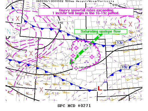
MESOSCALE DISCUSSION 0271
NWS STORM PREDICTION CENTER NORMAN OK
0755 AM CDT THU MAR 26 2009
AREAS AFFECTED...NERN COLORADO PLAINS AND ERN SLOPES OF FOOTHILLS
CONCERNING...HEAVY SNOW
VALID 261255Z - 261600Z
SNOWFALL INTENSITY WILL GRADUALLY INCREASE ACROSS PARTS OF THE NERN
COLORADO PLAINS AND ERN SLOPES OF FOOTHILLS. SNOWFALL RATES
EXCEEDING 1 INCH/HR ARE PROBABLE BEGINNING IN THE 16-19Z PERIOD.
MORNING SATELLITE IMAGERY INDICATES MID LEVEL VORTICITY MAXIMUM
ACROSS SWRN WY WITH INCREASING ASCENT IMPLIED BY MOISTENING/COOLING
CLOUD TOPS BEGINNING TO SPREAD ACROSS NRN COLORADO. SURFACE
MESOANALYSIS SHOWS SLOW MOVING COLD FRONT DRAPED W-E FROM SRN WY
INTO PLATTE RIVER VALLEY. THIS FEATURE IS BEGINNING TO ACCELERATE
SWD AND WILL BE INVOF SERN COLORADO BY 19Z. BEHIND THIS
FEATURE...STRONG N-NELY/S WILL DEVELOP...ENHANCING UPSLOPE FLOW
COMPONENT.
12Z DNR RAOB EXHIBITED NEARLY SATURATED COLUMN UP THROUGH 500 MB.
ENHANCED UVV/S AND UPSLOPE FLOW WILL AUGMENT DEEP ASCENT THROUGH THE
COLUMN YIELDING INCREASING SNOWFALL RATES NEARING 1 INCH/HR. LATEST
RUNS OF 4KM HIGH RESOLUTION MODELS AND SREF OUTPUT INDICATE SNOWFALL
RATES WILL INTENSIFY SUBSTANTIALLY IN THE 16-19Z PERIOD...BEGINNING
FIRST NEAR DNR / FCL AND ADJACENT FOOTHILLS. CONDITIONS WILL
PROGRESSIVELY DETERIORATE THIS AFTERNOON IN THE 19-22Z PERIOD AS
STRONGER WINDS /GUSTS AOA 40 MPH/ AND MORE INTENSE SNOWFALL RATES /1
TO 2 INCH/HR RATES/ REDUCE VISIBILITIES CREATING BLIZZARD
CONDITIONS.
..SMITH.. 03/26/2009
ATTN...WFO...GLD...PUB...BOU...
0 likes
Re: Denver LACK OF snow/winter thread
4" already and the "heavy" stuff is this afternoon. Blizzard like conditions now. Quite impressed.
0 likes
Who is online
Users browsing this forum: No registered users and 160 guests