ATL: TROPICAL DEPRESSION ALEX - DISCUSSION
Moderator: S2k Moderators
-
srainhoutx

- S2K Supporter

- Posts: 6919
- Age: 68
- Joined: Sun Jan 14, 2007 11:34 am
- Location: Haywood County, NC
- Contact:
Re: ATL: INVEST 93L - DISCUSSION
We will see what D-max can do convection wise tonight...
0 likes
Carla/Alicia/Jerry(In The Eye)/Michelle/Charley/Ivan/Dennis/Katrina/Rita/Wilma/Ike/Harvey
Member: National Weather Association
Wx Infinity Forums
http://wxinfinity.com/index.php
Facebook.com/WeatherInfinity
Twitter @WeatherInfinity
Member: National Weather Association
Wx Infinity Forums
http://wxinfinity.com/index.php
Facebook.com/WeatherInfinity
Twitter @WeatherInfinity


-
Ikester
- Professional-Met

- Posts: 361
- Age: 40
- Joined: Mon Jun 21, 2010 5:00 pm
- Location: Jacksonville, FL
Re: ATL: INVEST 93L - DISCUSSION
New here, guys/gals. Be polite! LOL. I have meteorological background and look forward to great discussions. Enough of that. Here's my first post. It appears as though our blob is trying to develop a closed circulation. See image below.

0 likes
-
tolakram
- Admin

- Posts: 20186
- Age: 62
- Joined: Sun Aug 27, 2006 8:23 pm
- Location: Florence, KY (name is Mark)
Re: ATL: INVEST 93L - DISCUSSION

0 likes
M a r k
- - - - -
Join us in chat: Storm2K Chatroom Invite. Android and IOS apps also available.
The posts in this forum are NOT official forecasts and should not be used as such. Posts are NOT endorsed by any professional institution or STORM2K.org. For official information and forecasts, please refer to NHC and NWS products.
-
AdamFirst

- S2K Supporter
- Posts: 2490
- Age: 36
- Joined: Thu Aug 14, 2008 10:54 am
- Location: Port Saint Lucie, FL
The local TV mets around here are giving us the "keep an eye out" rhetoric with 93L. They seem more concerned with this one than they ever were with 92L. The NBC met says a depression could form a couple days down the road.
0 likes
Dolphins Marlins Canes Golden Panthers HEAT
Andrew 1992 - Irene 1999 - Frances 2004 - Jeanne 2004 - Wilma 2005 - Fay 2008 - Isaac 2012 - Matthew 2016 - Irma 2017 - Dorian 2019 - Ian 2022 - Nicole 2022 - Milton 2024
Andrew 1992 - Irene 1999 - Frances 2004 - Jeanne 2004 - Wilma 2005 - Fay 2008 - Isaac 2012 - Matthew 2016 - Irma 2017 - Dorian 2019 - Ian 2022 - Nicole 2022 - Milton 2024
-
HURAKAN

- Professional-Met
- Posts: 46084
- Age: 39
- Joined: Thu May 20, 2004 4:34 pm
- Location: Key West, FL
- Contact:
Re: ATL: INVEST 93L - DISCUSSION

Areas that I think need to keep an eye on this system, especially from Yucatan to W. Cuba
Personal Forecast Disclaimer:
The posts in this forum are NOT official forecast and should not be used as such. They are just the opinion of the poster and may or may not be backed by sound meteorological data. They are NOT endorsed by any professional institution or storm2k.org. For official information, please refer to the NHC and NWS products.
0 likes

Re:
AdamFirst wrote:The local TV mets around here are giving us the "keep an eye out" rhetoric with 93L. They seem more concerned with this one than they ever were with 92L. The NBC met says a depression could form a couple days down the road.
Thats probably mostly to do with the fact that 92L was rather far away and climatology was very much against it, whilst this one is closer to home so to speak and has climatology on its side to some extent.
0 likes
Personal Forecast Disclaimer:
The posts in this forum are NOT official forecast and should not be used as such. They are just the opinion of the poster and may or may not be backed by sound meteorological data. They are NOT endorsed by any professional institution or storm2k.org. For official information, please refer to the NHC and NWS products
The posts in this forum are NOT official forecast and should not be used as such. They are just the opinion of the poster and may or may not be backed by sound meteorological data. They are NOT endorsed by any professional institution or storm2k.org. For official information, please refer to the NHC and NWS products
-
hurricanetrack

- HurricaneTrack.com

- Posts: 1781
- Joined: Tue Dec 02, 2003 10:46 pm
- Location: Wilmington, NC
- Contact:
I don't know. None of the models are really bullish on this. Certainly not the GFS and it nailed 92L as NOT developing. The Euro with its flip-flopping is not consistent. Heck, the hurricane-out-of-a-mole-hill CMC even shows little to nothing. No model consensus to speak of and a lack of any really well defined system leads me to believe we are still going to be watching a whole lotta nothing these next few days. Still interesting to watch.
0 likes

-
hurricanehunter69
- Category 1

- Posts: 344
- Joined: Sun May 16, 2010 5:21 pm
- Location: New Orleans
I think the fact that we're even discussing development of 93L on june 21st, while passing through the graveyard is amazing! These early ripe conditions in climatologically unfavored areas should be a forbodeing sign of things to come....As for my take on 93L. The close interaction with SA, and it's attachement to the ITCZ are obvious inhibitors..However, conditions do appear conducive later on down the road, and we could be looking at explosive development if no inhibiting factors are in place once it reaches the NW caribbean.
0 likes

Re: ATL: INVEST 93L - DISCUSSION
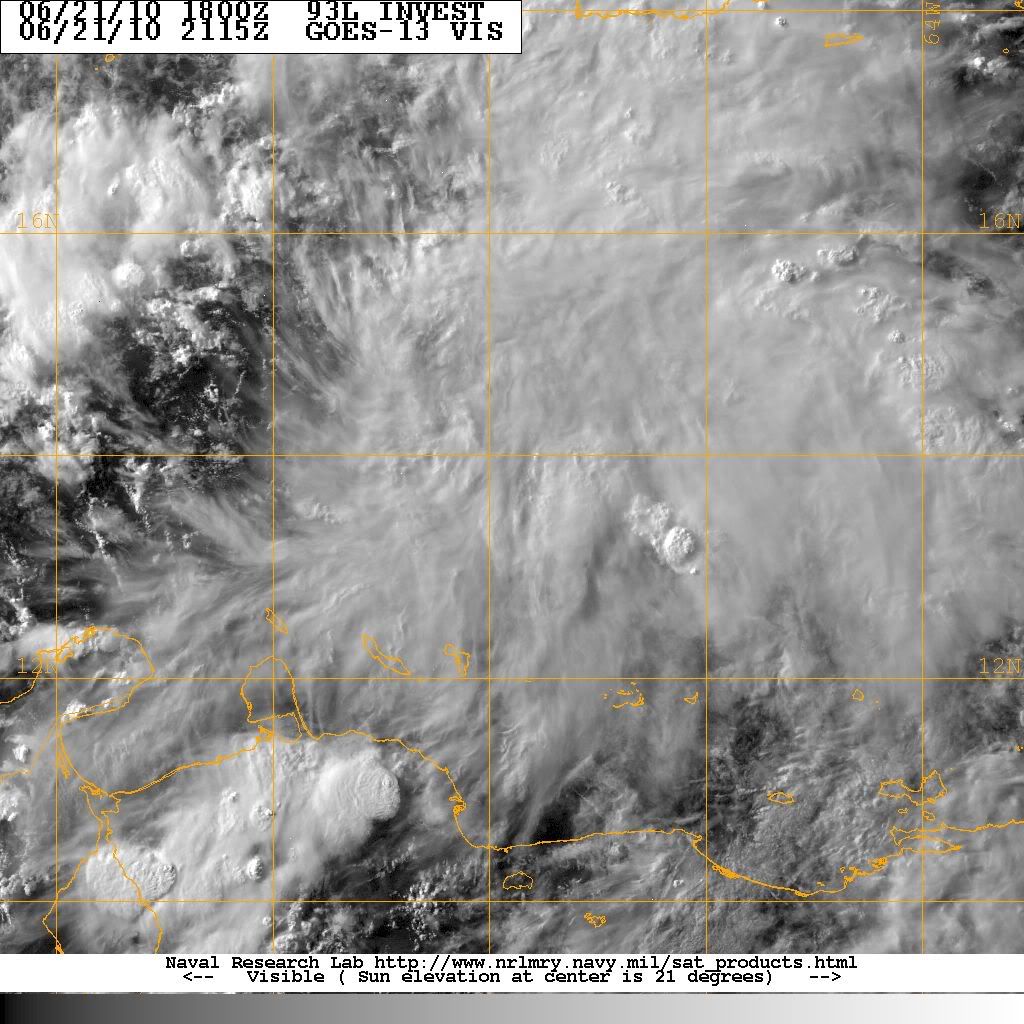
Is there a low pressure area associated with this system? I ask because I dont see any rotation at all. Even 95E has some nice rotation, but not 93L.
0 likes
-
HURAKAN
- Professional-Met
- Posts: 46084
- Age: 39
- Joined: Thu May 20, 2004 4:34 pm
- Location: Key West, FL
- Contact:
Re: ATL: INVEST 93L - DISCUSSION
I-wall wrote:Is there a low pressure area associated with this system? I ask because I dont see any rotation at all. Even 95E has some nice rotation, but not 93L.
Not at the moment, just a tropical wave.
0 likes

-
x-y-no

- Category 5
- Posts: 8359
- Age: 65
- Joined: Wed Aug 11, 2004 12:14 pm
- Location: Fort Lauderdale, FL
Re: ATL: INVEST 93L - DISCUSSION
Ikester wrote:New here, guys/gals. Be polite! LOL. I have meteorological background and look forward to great discussions. Enough of that. Here's my first post. It appears as though our blob is trying to develop a closed circulation. See image below.
How is this image generated? This is satellite scatterometry, I guess? What satellite instruments are involved?
0 likes
-
HURAKAN
- Professional-Met
- Posts: 46084
- Age: 39
- Joined: Thu May 20, 2004 4:34 pm
- Location: Key West, FL
- Contact:
Re: ATL: INVEST 93L - DISCUSSION
x-y-no wrote:How is this image generated? This is satellite scatterometry, I guess? What satellite instruments are involved?
Multi-Platform Tropical Cyclone Surface Wind Analysis
Currently, this product combines information from five data sources to create a mid-level (near 700 hPa) wind analysis using a variational approach described in Knaff and DeMaria (2006). The resulting mid-level winds are then adjusted to the surface applying a very simple single column approach. Over the ocean an adjustment factor is applied, which is a function of radius from the center ranging from 0.9 to 0.7, and the winds are turned 20 degrees toward low pressure. Over land, the oceanic winds are reduced by an additional 20% and turned an additional 20 degrees toward low pressure.
The five datasets currently used are the ASCAT scatterometer, which is adjusted upward to 700 hPa in the same manner as the surface winds are adjusted downward, feature track winds in the mid-levels from the operational satellite centers, 2-d flight-level winds estimated from infrared imagery (see Mueller et al 2006 ) and 2-d winds created from Advanced Microwave Sounding Unit (AMSU)- derived height fields and solving the non-linear balance equations as described in Bessho et al (2006). Past analyses also made use of the QuickSCAT scatterometer (i.e., prior to November 2009), but this satellite is no longer producing observations of surface vector winds.
Each of the input data are shown in subpanels following the analysis (i.e., storm-relative). Shown are AMSU winds, Cloud-drift/IR/WV winds, IR-proxy winds and Scatterometer winds; QuikSCAT, when available for past analyses (BLUE) and ASCAT (RED). All input data in these panels has been reduced to a 10-m land or oceanic exposure depending on the location (i.e., non-surface data has been reduced to a 10-m exposure).
How good are the wind estimates? Here is the verification based upon 2007 data . These statistics were based on 1) H*Wind data when available and 2) best track wind radii estimates from NHC. In interpreting the wind radii verification it is important to not that the zero wind radii are included in the verification, which both skews and inflates the MAE verification statistics. Note however detection is improved over climatology provided by Knaff et al. (2007).
Link - http://rammb.cira.colostate.edu/product ... p#MPSATWND
0 likes
Re:
hurricanetrack wrote:I don't know. None of the models are really bullish on this. Certainly not the GFS and it nailed 92L as NOT developing. The Euro with its flip-flopping is not consistent. Heck, the hurricane-out-of-a-mole-hill CMC even shows little to nothing. No model consensus to speak of and a lack of any really well defined system leads me to believe we are still going to be watching a whole lotta nothing these next few days. Still interesting to watch.
Yeah the models aren't too bullish apart from that 0z ECM, but I'm not sure that they are actually latching onto what will develop, that quite a large area of convection at the moment. Chances will probably go back down though given the convection has weakened.
Still its going into an area that has seen plenty of development at this time of the year and there will be good conditiond aloft as well...so needs watching.
0 likes
Personal Forecast Disclaimer:
The posts in this forum are NOT official forecast and should not be used as such. They are just the opinion of the poster and may or may not be backed by sound meteorological data. They are NOT endorsed by any professional institution or storm2k.org. For official information, please refer to the NHC and NWS products
The posts in this forum are NOT official forecast and should not be used as such. They are just the opinion of the poster and may or may not be backed by sound meteorological data. They are NOT endorsed by any professional institution or storm2k.org. For official information, please refer to the NHC and NWS products
-
HURAKAN
- Professional-Met
- Posts: 46084
- Age: 39
- Joined: Thu May 20, 2004 4:34 pm
- Location: Key West, FL
- Contact:
Re: Re:
KWT wrote:Yeah the models aren't too bullish apart from that 0z ECM, but I'm not sure that they are actually latching onto what will develop, that quite a large area of convection at the moment. Chances will probably go back down though given the convection has weakened.
Unlikely to go back down bc since there is no well-defined LLC, convection should decrease during D-MIN and increase during D-MAX
0 likes
-
Hurricanewatcher2007

- Category 2

- Posts: 578
- Joined: Sat Jul 05, 2008 8:10 pm
Re: Re:
KWT wrote:hurricanetrack wrote:I don't know. None of the models are really bullish on this. Certainly not the GFS and it nailed 92L as NOT developing. The Euro with its flip-flopping is not consistent. Heck, the hurricane-out-of-a-mole-hill CMC even shows little to nothing. No model consensus to speak of and a lack of any really well defined system leads me to believe we are still going to be watching a whole lotta nothing these next few days. Still interesting to watch.
Yeah the models aren't too bullish apart from that 0z ECM, but I'm not sure that they are actually latching onto what will develop, that quite a large area of convection at the moment. Chances will probably go back down though given the convection has weakened.
Still its going into an area that has seen plenty of development at this time of the year and there will be good conditiond aloft as well...so needs watching.
If I were the forecasters I wouldn't decrease the chances just because convection died out during the day which is to be expected. If the overall trend were that the convection was dieing then yes. but They just increased the chances this morning which is hardly enough time to see a overall pattern suggestive of a invest dieing. If they based it on the convection from update to update then every morning they would increase the chances and every evening they would decrease the chances which wouldn't look very good for them. The general over view for 93L is that it's a active tropical wave moving into an area of lighter wind shear, over boiling hot water with plenty of oceanic heat content to power a cat 4 or 5 sub-900mb Hurricane.
0 likes
-
littlevince

- S2K Supporter
- Posts: 768
- Joined: Fri Oct 21, 2005 10:45 am
- Location: Portugal

Who is online
Users browsing this forum: No registered users and 33 guests