EPAC: AMANDA - Post-Tropical

Moderator: S2k Moderators

Message
Author
User avatar
Yellow Evan
Professional-Met
Professional-Met
Posts: 16143
Age: 27
Joined: Fri Jul 15, 2011 12:48 pm
Location: Henderson, Nevada/Honolulu, HI
Contact:

Re: EPAC: AMANDA - Hurricane

#161 Postby Yellow Evan » Sat May 24, 2014 12:25 pm

xtyphooncyclonex wrote:
tolakram wrote:From the FTP site, 1630Z

Image

ftp://goes.gsfc.nasa.gov/pub/goeswest/overview2/vis/

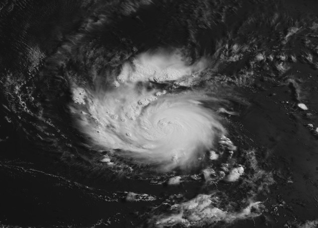
So far, this is the most impressive NHem storm this year. IMO, that look of Amanda is a typical look of rapidly intensifying (but quite midget) hurricanes and typhoons, which remind me of what happened during Raymond, Adrian, Utor and Soulik. What was the strongest May ePac storm on record, BTW?


Adolph 01

https://en.wikipedia.org/wiki/Hurricane ... %282001%29

Image
0 likes   

User avatar
SouthDadeFish
Professional-Met
Professional-Met
Posts: 2835
Joined: Thu Sep 23, 2010 2:54 pm
Location: Miami, FL
Contact:

#162 Postby SouthDadeFish » Sat May 24, 2014 12:27 pm

Amanda is reaping the benefits of a great poleward outflow jet and warm SSTs. With the very small core, rapid intensity changes are likely. If the eye clears out soon, look for ADT numbers to skyrocket.
0 likes   

User avatar
Yellow Evan
Professional-Met
Professional-Met
Posts: 16143
Age: 27
Joined: Fri Jul 15, 2011 12:48 pm
Location: Henderson, Nevada/Honolulu, HI
Contact:

Re:

#163 Postby Yellow Evan » Sat May 24, 2014 12:33 pm

SouthDadeFish wrote:Amanda is reaping the benefits of a great poleward outflow jet and warm SSTs. With the very small core, rapid intensity changes are likely. If the eye clears out soon, look for ADT numbers to skyrocket.


Looking at the loops, the eye does appear to be becoming more defined. I'd go with 70 or 75 knts now.
0 likes   

User avatar
TropicalAnalystwx13
Category 5
Category 5
Posts: 2109
Age: 27
Joined: Tue Jul 19, 2011 8:20 pm
Location: Wilmington, NC
Contact:

#164 Postby TropicalAnalystwx13 » Sat May 24, 2014 1:13 pm

A little late here, but the 12z SHIPS indicated a 6/10 chance of a 40kt increase in winds over the next 24 hours. That's the highest I've seen in quite a while.
0 likes   

User avatar
cycloneye
Admin
Admin
Posts: 145294
Age: 68
Joined: Thu Oct 10, 2002 10:54 am
Location: San Juan, Puerto Rico

Re: EPAC: AMANDA - Hurricane

#165 Postby cycloneye » Sat May 24, 2014 1:15 pm

The 12z model package has them reaching a intensity peak between high cat 2 and low cat 3.

Image
0 likes   
Visit the Caribbean-Central America Weather Thread where you can find at first post web cams,radars
and observations from Caribbean basin members Click Here

User avatar
Yellow Evan
Professional-Met
Professional-Met
Posts: 16143
Age: 27
Joined: Fri Jul 15, 2011 12:48 pm
Location: Henderson, Nevada/Honolulu, HI
Contact:

#166 Postby Yellow Evan » Sat May 24, 2014 1:20 pm

Is it possible the brief unarrested development earlier was due to a little dry air?
0 likes   

User avatar
cycloneye
Admin
Admin
Posts: 145294
Age: 68
Joined: Thu Oct 10, 2002 10:54 am
Location: San Juan, Puerto Rico

Re: EPAC: AMANDA - Hurricane

#167 Postby cycloneye » Sat May 24, 2014 1:42 pm

Up to 70kts.

EP, 01, 2014052418, , BEST, 0, 113N, 1101W, 70, 987, HU
0 likes   
Visit the Caribbean-Central America Weather Thread where you can find at first post web cams,radars
and observations from Caribbean basin members Click Here

SeGaBob

Re: Re:

#168 Postby SeGaBob » Sat May 24, 2014 2:09 pm

TropicalAnalystwx13 wrote:
Yellow Evan wrote:Any chance at Cat 4 status?

There's always a chance for surprises when dealing with small, rapidly-intensifying hurricanes. I wouldn't say it's particularly likely, but I wouldn't say it can't reach Category 4 either.


Anything could happen... this time yesterday we didn't really think there was a decent chance of a category 3 but then again it could just magically poof.
0 likes   

tolakram
Admin
Admin
Posts: 20009
Age: 62
Joined: Sun Aug 27, 2006 8:23 pm
Location: Florence, KY (name is Mark)

Re: EPAC: AMANDA - Hurricane

#169 Postby tolakram » Sat May 24, 2014 2:26 pm

19:00Z
Image
0 likes   
M a r k
- - - - -
Join us in chat: Storm2K Chatroom Invite. Android and IOS apps also available.

The posts in this forum are NOT official forecasts and should not be used as such. Posts are NOT endorsed by any professional institution or STORM2K.org. For official information and forecasts, please refer to NHC and NWS products.

hurricanes1234
Category 5
Category 5
Posts: 2907
Joined: Sat Jul 28, 2012 6:19 pm
Location: Trinidad and Tobago

#170 Postby hurricanes1234 » Sat May 24, 2014 3:40 pm

000
WTPZ41 KNHC 242033
TCDEP1

HURRICANE AMANDA DISCUSSION NUMBER 9
NWS NATIONAL HURRICANE CENTER MIAMI FL EP012014
200 PM PDT SAT MAY 24 2014

Amanda's eye is becoming more apparent in visible imagery. The
hurricane has a fairly small central dense overcast with one
prominent convective band curving around the western and northern
side of the circulation. Dvorak estimates from TAFB and SAB are
T4.0/65 kt, and the objective ADT has been steady around 70 kt for
the past few hours. The initial intensity is raised to 70 kt based
on the ADT estimate and the development of an eye in visible
imagery.

Amanda likely has another 36 hours or so of favorable conditions
for intensification before southerly vertical wind shear begins to
increase. The rate of intensification may have slowed down just a
bit, but there's no real good reason not to expect further
strengthening in the short term. One potential limiting factor
could be upwelling of colder ocean water due to the slow movement of
the hurricane during the next few days. The intensity guidance has
backed off a bit on this cycle, with many of the models peaking the
maximum winds just below major hurricane strength. Only the Florida
State Superensemble explicitly shows Amanda becoming a major
hurricane in 24-36 hours. Nonetheless, Amanda is forecast to be
right around the major hurricane threshold of 100 kt in a day or
so. After 36 hours, higher vertical shear should induce a fairly
fast weakening trend, and the NHC forecast now shows Amanda
becoming a tropical depression by day 5.

Amanda's motion remains 290/4 kt. The hurricane should begin
turning northwestward within 24 hours and then northward by 36
hours as the mid-level ridge over Mexico weakens. A slightly
faster motion may develop in about 48 hours due to a
restrengthening of the mid-level ridge over Mexico and an
amplification of a mid-level low near 130W. The NHC forecast has
again been shifted a bit to the right toward the tracks of the
GFS and ECMWF, both of which lie along the eastern edge of the
guidance envelope.

FORECAST POSITIONS AND MAX WINDS

INIT 24/2100Z 11.4N 110.3W 70 KT 80 MPH
12H 25/0600Z 11.5N 110.7W 85 KT 100 MPH
24H 25/1800Z 12.0N 111.1W 95 KT 110 MPH
36H 26/0600Z 12.6N 111.2W 100 KT 115 MPH
48H 26/1800Z 13.5N 111.3W 90 KT 105 MPH
72H 27/1800Z 15.0N 111.5W 70 KT 80 MPH
96H 28/1800Z 16.0N 111.5W 45 KT 50 MPH
120H 29/1800Z 16.5N 111.0W 30 KT 35 MPH

$$
Forecaster Berg
0 likes   
PLEASE NOTE: With the exception of information from weather agencies that I may copy and paste here, my posts will NEVER be official, since I am NOT a meteorologist. They are solely my amateur opinion, and may or may not be accurate. Therefore, please DO NOT use them as official details, particularly when making important decisions. Thank you.

hurricanes1234
Category 5
Category 5
Posts: 2907
Joined: Sat Jul 28, 2012 6:19 pm
Location: Trinidad and Tobago

#171 Postby hurricanes1234 » Sat May 24, 2014 4:46 pm

Latest frame shows a ring of convection completely wrapping around the small and newly formed eye or eye-like structure. Based on that alone, I would think some serious intensification is definitely going on now. However, I'm only amateur.
0 likes   
PLEASE NOTE: With the exception of information from weather agencies that I may copy and paste here, my posts will NEVER be official, since I am NOT a meteorologist. They are solely my amateur opinion, and may or may not be accurate. Therefore, please DO NOT use them as official details, particularly when making important decisions. Thank you.

User avatar
Yellow Evan
Professional-Met
Professional-Met
Posts: 16143
Age: 27
Joined: Fri Jul 15, 2011 12:48 pm
Location: Henderson, Nevada/Honolulu, HI
Contact:

Re:

#172 Postby Yellow Evan » Sat May 24, 2014 5:02 pm

hurricanes1234 wrote:Latest frame shows a ring of convection completely wrapping around the small and newly formed eye or eye-like structure. Based on that alone, I would think some serious intensification is definitely going on now. However, I'm only amateur.


It's starting to ramp up again. It could be a Cat 2 tonight IMO.
0 likes   

User avatar
Yellow Evan
Professional-Met
Professional-Met
Posts: 16143
Age: 27
Joined: Fri Jul 15, 2011 12:48 pm
Location: Henderson, Nevada/Honolulu, HI
Contact:

Re: EPAC: AMANDA - Hurricane

#173 Postby Yellow Evan » Sat May 24, 2014 5:10 pm

Image
0 likes   

User avatar
Kingarabian
S2K Supporter
S2K Supporter
Posts: 15980
Joined: Sat Aug 08, 2009 3:06 am
Location: Honolulu, Hawaii

#174 Postby Kingarabian » Sat May 24, 2014 5:24 pm

Deepening is happening right now.

Image
0 likes   
RIP Kobe Bryant

hurricanes1234
Category 5
Category 5
Posts: 2907
Joined: Sat Jul 28, 2012 6:19 pm
Location: Trinidad and Tobago

#175 Postby hurricanes1234 » Sat May 24, 2014 5:30 pm

I know this may be a little far-fetched, but do you think a special update will be issued at 5:00 PM PDT?
0 likes   
PLEASE NOTE: With the exception of information from weather agencies that I may copy and paste here, my posts will NEVER be official, since I am NOT a meteorologist. They are solely my amateur opinion, and may or may not be accurate. Therefore, please DO NOT use them as official details, particularly when making important decisions. Thank you.
User avatar
Yellow Evan
Professional-Met
Professional-Met
Posts: 16143
Age: 27
Joined: Fri Jul 15, 2011 12:48 pm
Location: Henderson, Nevada/Honolulu, HI
Contact:

Re:

#176 Postby Yellow Evan » Sat May 24, 2014 5:39 pm

hurricanes1234 wrote:I know this may be a little far-fetched, but do you think a special update will be issued at 5:00 PM PDT?


Doubt it, given it's not a threat to land. Honestly, I'd say this 75-80 knts max.
0 likes   

User avatar
Steve820
Tropical Storm
Tropical Storm
Posts: 188
Age: 25
Joined: Sat May 17, 2014 8:04 pm
Location: Southern California
Contact:

Re:

#177 Postby Steve820 » Sat May 24, 2014 5:40 pm

hurricanes1234 wrote:I know this may be a little far-fetched, but do you think a special update will be issued at 5:00 PM PDT?


Possibly, but only if it continues to rapidly strengthen to the point that the NHC have to rush an advisory. I can't wait until Amanda achieves major hurricane status! It'll be the first May major since Bud in 2012.
0 likes   
Hurricanes are an amazing natural phenomena. While many are spiraling pits of evil that kill people or cause devastation, some are tame and stay clear of land.

I wish for you to :Bcool:

hurricanes1234
Category 5
Category 5
Posts: 2907
Joined: Sat Jul 28, 2012 6:19 pm
Location: Trinidad and Tobago

Re: EPAC: AMANDA - Hurricane

#178 Postby hurricanes1234 » Sat May 24, 2014 6:02 pm

Just wow. I'd personally estimate an intensity of 85 knots now. Look at that perfect ring of red and the partial ring of grey. :eek:

Image

IMPORTANT: This picture may not be compatible with some devices (it is a GIF file).
0 likes   
PLEASE NOTE: With the exception of information from weather agencies that I may copy and paste here, my posts will NEVER be official, since I am NOT a meteorologist. They are solely my amateur opinion, and may or may not be accurate. Therefore, please DO NOT use them as official details, particularly when making important decisions. Thank you.

User avatar
Extratropical94
Professional-Met
Professional-Met
Posts: 3538
Age: 30
Joined: Wed Oct 20, 2010 6:36 am
Location: Hamburg, Germany
Contact:

#179 Postby Extratropical94 » Sat May 24, 2014 6:30 pm

Now that the ADT's detect an eye, the raw T-numbers are shooting up.

CIMSS:

Code: Select all

                CI# /Pressure/ Vmax
                4.3 / 985.9mb/ 72.2kt

     
             Final T#  Adj T#  Raw T#
                4.3     4.7     6.3
 Estimated radius of max. wind based on IR :<10 km

 Center Temp : -24.1C    Cloud Region Temp : -71.3C

 Scene Type : PINHOLE EYE

SSD:
2014MAY24 223000 4.4 984.2 74.6 4.4 4.9 6.0 0.5T/hour OFF OFF -24.13 -71.31 EYE/P
0 likes   
54° 11' 59'' N, 9° 9' 20'' E
Boomer Sooner!
Go Broncos! Go Cards! Go Niners!
- Daniel

User avatar
cycloneye
Admin
Admin
Posts: 145294
Age: 68
Joined: Thu Oct 10, 2002 10:54 am
Location: San Juan, Puerto Rico

Re: EPAC: AMANDA - Hurricane

#180 Postby cycloneye » Sat May 24, 2014 6:31 pm

Eye clearing.

Image
0 likes   
Visit the Caribbean-Central America Weather Thread where you can find at first post web cams,radars
and observations from Caribbean basin members Click Here


Return to “2014”

Who is online

Users browsing this forum: No registered users and 6 guests