ATL: KAREN - Models
Moderator: S2k Moderators
-
Ivanhater

- Storm2k Moderator

- Posts: 11221
- Age: 39
- Joined: Fri Jul 01, 2005 8:25 am
- Location: Pensacola
Re: ATL: INVEST 99L - Models
Does anyone have a map of the last 3 runs of the euro ensembles to compare to?
0 likes
Michael
Re: ATL: INVEST 99L - Models
To clarify why I said 18 CONUS hits, your map shows only 12 because it only goes through 240. But 6 additional members hit after 240 for a total of 18.
0 likes
Personal Forecast Disclaimer:
The posts in this forum are NOT official forecasts and should not be used as such. They are just the opinion of the poster and may or may not be backed by sound meteorological data. They are NOT endorsed by any professional institution or storm2k.org. For official information, please refer to the NHC and NWS products.
The posts in this forum are NOT official forecasts and should not be used as such. They are just the opinion of the poster and may or may not be backed by sound meteorological data. They are NOT endorsed by any professional institution or storm2k.org. For official information, please refer to the NHC and NWS products.
-
USTropics
- Professional-Met

- Posts: 2737
- Joined: Sun Aug 12, 2007 3:45 am
- Location: Florida State University
Re: ATL: INVEST 99L - Models
Ivanhater wrote:Does anyone have a map of the last 3 runs of the euro ensembles to compare to?
Past 4 cycles:

src: https://ruc.noaa.gov/hfip/tceps/tceps.php?stm=99L.2019&dtg=2019092200
3 likes
-
Ivanhater
- Storm2k Moderator
- Posts: 11221
- Age: 39
- Joined: Fri Jul 01, 2005 8:25 am
- Location: Pensacola
Re: ATL: INVEST 99L - Models
USTropics wrote:Ivanhater wrote:Does anyone have a map of the last 3 runs of the euro ensembles to compare to?
Past 4 cycles:
https://i.ibb.co/g7mRwzJ/Webp-net-gifmaker-1.gif
src: https://ruc.noaa.gov/hfip/tceps/tceps.php?stm=99L.2019&dtg=2019092200
Thank you. That really shows the trend and when folks see the trend tonight , all eyes on deck...
1 likes
Michael
-
jlauderdal
- S2K Supporter

- Posts: 7240
- Joined: Wed May 19, 2004 5:46 am
- Location: NE Fort Lauderdale
- Contact:
Re: ATL: KAREN - Models
there is plenty of model support for the ridge to build back in, florida to nova scotia be on alertIvanhater wrote:USTropics wrote:Ivanhater wrote:Does anyone have a map of the last 3 runs of the euro ensembles to compare to?
Past 4 cycles:
https://i.ibb.co/g7mRwzJ/Webp-net-gifmaker-1.gif
src: https://ruc.noaa.gov/hfip/tceps/tceps.php?stm=99L.2019&dtg=2019092200
Thank you. That really shows the trend and when folks see the trend tonight , all eyes on deck...
0 likes
-
northjaxpro

- S2K Supporter
- Posts: 8900
- Joined: Mon Sep 27, 2010 11:21 am
- Location: Jacksonville, FL
Re: ATL: KAREN - Models
jlauderdal wrote:there is plenty of model support for the ridge to build back in, florida to nova scotia be on alertIvanhater wrote:USTropics wrote:
Past 4 cycles:
https://i.ibb.co/g7mRwzJ/Webp-net-gifmaker-1.gif
src: https://ruc.noaa.gov/hfip/tceps/tceps.php?stm=99L.2019&dtg=2019092200
Thank you. That really shows the trend and when folks see the trend tonight , all eyes on deck...
JLauderdal, I would add the Caribbean to that as well as that ridge looks so strong right now that Karen could get forced west/southwest to impact Cuba.
0 likes
NEVER, EVER SAY NEVER in the tropics and weather in general, and most importantly, with life itself!!
________________________________________________________________________________________
Fay 2008 Beryl 2012 Debby 2012 Colin 2016 Hermine 2016 Julia 2016 Matthew 2016 Irma 2017 Dorian 2019
________________________________________________________________________________________
Fay 2008 Beryl 2012 Debby 2012 Colin 2016 Hermine 2016 Julia 2016 Matthew 2016 Irma 2017 Dorian 2019
-
toad strangler

- S2K Supporter
- Posts: 4546
- Joined: Sun Jul 28, 2013 3:09 pm
- Location: Earth
- Contact:
Re: ATL: INVEST 99L - Models
Kingarabian wrote:Wow the 00z Euro is crazy. 2019 seems to be the year of un-orthodox tracks.
In model land, not in reality
1 likes
My Weather Station
https://www.wunderground.com/dashboard/pws/KFLPORTS603
https://www.wunderground.com/dashboard/pws/KFLPORTS603


Re: ATL: KAREN - Models
Meanwhile 06z GFS much weaker west into S FL and toward northern GOM.
https://www.tropicaltidbits.com/analysis/models/?model=gfs®ion=us&pkg=z850_vort&runtime=2019092206&fh=300
https://www.tropicaltidbits.com/analysis/models/?model=gfs®ion=us&pkg=z850_vort&runtime=2019092206&fh=300
0 likes
-
toad strangler
- S2K Supporter
- Posts: 4546
- Joined: Sun Jul 28, 2013 3:09 pm
- Location: Earth
- Contact:
Re: ATL: KAREN - Models
ronjon wrote:Meanwhile 06z GFS much weaker west into S FL and toward northern GOM.
https://www.tropicaltidbits.com/analysis/models/?model=gfs®ion=us&pkg=z850_vort&runtime=2019092206&fh=300
Models were spitting out tiny little vorts with Dorian this far out.
0 likes
My Weather Station
https://www.wunderground.com/dashboard/pws/KFLPORTS603
https://www.wunderground.com/dashboard/pws/KFLPORTS603
-
jlauderdal
- S2K Supporter
- Posts: 7240
- Joined: Wed May 19, 2004 5:46 am
- Location: NE Fort Lauderdale
- Contact:
Re: ATL: KAREN - Models
ronjon wrote:Meanwhile 06z GFS much weaker west into S FL and toward northern GOM.
https://www.tropicaltidbits.com/analysis/models/?model=gfs®ion=us&pkg=z850_vort&runtime=2019092206&fh=300
looks very dangerous for anyone south of 30...gfs and euro rarely agree this far out on troughs and ridges, they could both be wrong
2 likes
-
AdamFirst

- S2K Supporter
- Posts: 2490
- Age: 36
- Joined: Thu Aug 14, 2008 10:54 am
- Location: Port Saint Lucie, FL
Re: ATL: KAREN - Models
Looking like another week of long nights ahead of us, folks. Hoping something like the GFS verifies rather than the Euro.
1 likes
Dolphins Marlins Canes Golden Panthers HEAT
Andrew 1992 - Irene 1999 - Frances 2004 - Jeanne 2004 - Wilma 2005 - Fay 2008 - Isaac 2012 - Matthew 2016 - Irma 2017 - Dorian 2019 - Ian 2022 - Nicole 2022 - Milton 2024
Andrew 1992 - Irene 1999 - Frances 2004 - Jeanne 2004 - Wilma 2005 - Fay 2008 - Isaac 2012 - Matthew 2016 - Irma 2017 - Dorian 2019 - Ian 2022 - Nicole 2022 - Milton 2024
-
gatorcane

- S2K Supporter
- Posts: 23708
- Age: 48
- Joined: Sun Mar 13, 2005 3:54 pm
- Location: Boca Raton, FL
Re: ATL: KAREN - Models
0 likes
-
gatorcane
- S2K Supporter
- Posts: 23708
- Age: 48
- Joined: Sun Mar 13, 2005 3:54 pm
- Location: Boca Raton, FL
Re: ATL: INVEST 99L - Models
LarryWx wrote:It ends up at 240 in far SE Gulf moving NNW.
The 500MB high is rapidly weakening too, could even go N then NE into Florida if the run went out further.
0 likes
-
Blown Away

- S2K Supporter
- Posts: 10253
- Joined: Wed May 26, 2004 6:17 am
Re: ATL: KAREN - Models
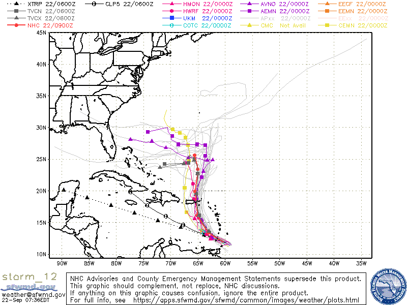
gatorcane wrote::eek: west turn and the Euro ensembles are not even on there where most turn towards Bahamas and many into Florida:
https://i.postimg.cc/ZnD4jT1m/storm-12-ens.gif
If the NHC buys this hard left, they will likely start showing it in the next advisories. The model turn starts after day 5, that’s why we see a subtle bend in the NHC track at day 5 point.
2 likes
Hurricane Eye Experience: David 79, Irene 99, Frances 04, Jeanne 04, Wilma 05… Hurricane Brush Experience: Andrew 92, Erin 95, Floyd 99, Matthew 16, Irma 17, Ian 22, Nicole 22…
-
Ivanhater
- Storm2k Moderator
- Posts: 11221
- Age: 39
- Joined: Fri Jul 01, 2005 8:25 am
- Location: Pensacola
Re: ATL: KAREN - Models
Very extreme GFS and Euro solutions showing Karen getting into the Gulf, let's see what 12Z shows.
1 likes
Michael
-
SFLcane

- S2K Supporter
- Posts: 10281
- Age: 48
- Joined: Sat Jun 05, 2010 1:44 pm
- Location: Lake Worth Florida
Re: ATL: KAREN - Models
gatorcane wrote::eek: west turn and the Euro ensembles are not even on there where most turn towards Bahamas and many into Florida:
https://i.postimg.cc/ZnD4jT1m/storm-12-ens.gif
Wow I most say this one caught me by surprise could be a long week folks. Thankfully I still have all my water from Dorian just in case.
6 likes
-
jlauderdal
- S2K Supporter
- Posts: 7240
- Joined: Wed May 19, 2004 5:46 am
- Location: NE Fort Lauderdale
- Contact:
Re: ATL: KAREN - Models
Ivanhater wrote:Very extreme GFS and Euro solutions showing Karen getting into the Gulf, let's see what 12Z shows.
doesn't look extreme to me, looks very possible based on the ridging in place
0 likes
Re: ATL: KAREN - Models
I think if the early model runs taught us anything about Dorian and Humberto, we should take these model runs all with a huge grain of salt. Things can and will change this far out. And perhaps most importantly, the models so far this year have over predicted the strength of 500 mb ridging in the SW Atlantic and the US has been spared any significant impact from MDR storms. Now will the upper level pattern finally flip to one of strong ridging? Seems unlikely but you never know...
3 likes
-
jlauderdal
- S2K Supporter
- Posts: 7240
- Joined: Wed May 19, 2004 5:46 am
- Location: NE Fort Lauderdale
- Contact:
Re: ATL: KAREN - Models
Blown Away wrote:gatorcane wrote::eek: west turn and the Euro ensembles are not even on there where most turn towards Bahamas and many into Florida:
https://i.postimg.cc/ZnD4jT1m/storm-12-ens.gif
If the NHC buys this hard left, they will likely start showing it in the next advisories. The model turn starts after day 5, that’s why we see a subtle bend in the NHC track at day 5 point.
with gfs and euro support dont see how they can do anything other then a hard left, they made a hard right with dorian in the bahamas
1 likes

Re: ATL: KAREN - Models
The euro 240h is scary...but still 10 days so...you never know
I will say the 500mb setup says something will be there even if Karen isn't
I will say the 500mb setup says something will be there even if Karen isn't
Last edited by drezee on Sun Sep 22, 2019 7:24 am, edited 2 times in total.
0 likes
Who is online
Users browsing this forum: No registered users and 94 guests