EPAC: HILARY - Post-Tropical - Discussion

Moderator: S2k Moderators

Message
Author
User avatar
aspen
Category 5
Category 5
Posts: 8818
Joined: Sat Oct 12, 2019 7:10 pm
Location: Connecticut, USA

Re: EPAC: HILARY - Hurricane - Discussion

#161 Postby aspen » Thu Aug 17, 2023 6:25 pm

Yellow Evan wrote:https://cdn.discordapp.com/attachments/733552978572869632/1141872254595104838/IMG_9738.gif

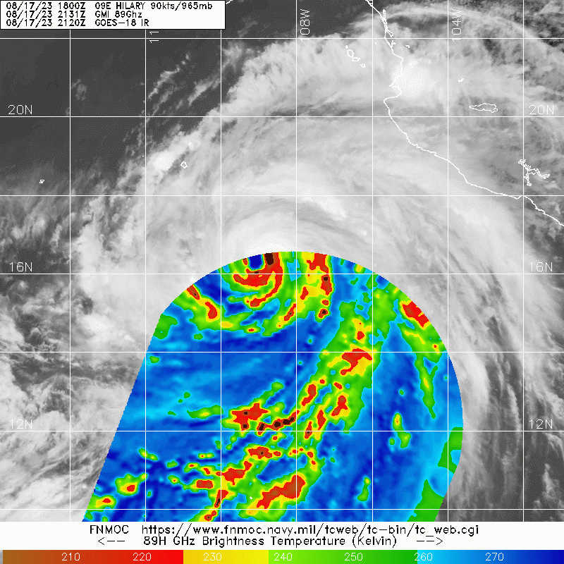
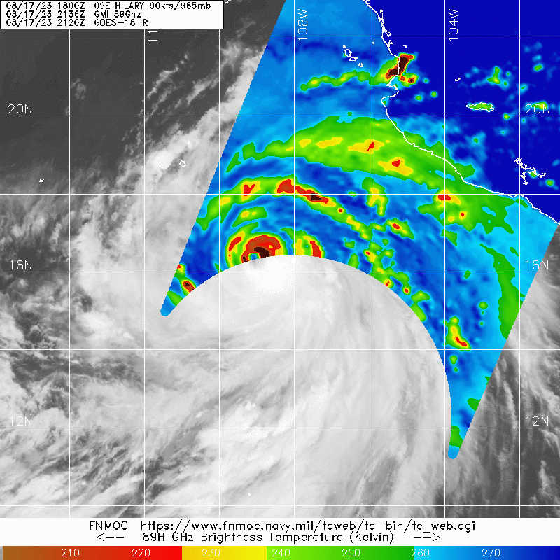
This is rotating fast. Given structure, I think mid-grade Category 4 is a decent bet but it's also ERC prone with that banding structure.

I think there’s a decent chance this banding structure results in an EWRC starting tomorrow and ending its RI phase a lot sooner than people expected. I hope recon will end up being timed well with Hilary’s peak.
1 likes   
Irene '11 Sandy '12 Hermine '16 5/15/2018 Derecho Fay '20 Isaias '20 Elsa '21 Henri '21 Ida '21

I am only a meteorology enthusiast who knows a decent amount about tropical cyclones. Look to the professional mets, the NHC, or your local weather office for the best information.

BobHarlem
Category 5
Category 5
Posts: 2104
Joined: Thu Oct 20, 2005 6:11 pm

Re: EPAC: HILARY - Hurricane - Discussion

#162 Postby BobHarlem » Thu Aug 17, 2023 6:30 pm

0 likes   

User avatar
MGC
S2K Supporter
S2K Supporter
Posts: 5899
Joined: Sun Mar 23, 2003 9:05 pm
Location: Pass Christian MS, or what is left.

Re: EPAC: HILARY - Hurricane - Discussion

#163 Postby MGC » Thu Aug 17, 2023 6:31 pm

Just texted my son in Reno and told him he was in the cone......he was like cone of what. I'm sure Hillary's surface circulation will be long gone but its mid level circulation should still be spinning over Nevada. When was the last time Southern Calfornia got hit?.....MGC
0 likes   

User avatar
Kingarabian
S2K Supporter
S2K Supporter
Posts: 15979
Joined: Sat Aug 08, 2009 3:06 am
Location: Honolulu, Hawaii

Re: EPAC: HILARY - Hurricane - Discussion

#164 Postby Kingarabian » Thu Aug 17, 2023 6:53 pm

All that banding it has means easier for dry air to get inside. Can see that on latest MW imagery.
Image
Image
0 likes   
RIP Kobe Bryant

User avatar
Ntxw
Storm2k Moderator
Storm2k Moderator
Posts: 22784
Joined: Wed Oct 21, 2009 6:34 pm
Location: DFW, Texas

Re: EPAC: HILARY - Hurricane - Discussion

#165 Postby Ntxw » Thu Aug 17, 2023 6:55 pm

Get that round eye and easy T7.0.

UW - CIMSS
ADVANCED DVORAK TECHNIQUE
ADT-Version 9.1
Tropical Cyclone Intensity Algorithm

----- Current Analysis -----
Date : 17 AUG 2023 Time : 232020 UTC
Lat : 16:17:59 N Lon : 109:22:12 W


CI# /Pressure/ Vmax
6.2 / 937.2mb/119.8kt


Final T# Adj T# Raw T#
6.2 6.3 6.7

Estimated radius of max. wind based on IR :N/A km

Center Temp : -8.3C Cloud Region Temp : -72.8C

Scene Type : EYE

Subtropical Adjustment : OFF

Extratropical Adjustment : OFF

Positioning Method : ARCHER POSITIONING

Ocean Basin : EAST PACIFIC
Dvorak CI > MSLP Conversion Used : CKZ Method

Tno/CI Rules : Constraint Limits : 1.3T/6hr
Weakening Flag : OFF
Rapid Dissipation Flag : OFF
0 likes   
The above post and any post by Ntxw is NOT an official forecast and should not be used as such. It is just the opinion of the poster and may or may not be backed by sound meteorological data. It is NOT endorsed by any professional institution including Storm2k. For official information, please refer to NWS products.

  Help support Storm2K!
Help Support Storm2K

User avatar
cycloneye
Admin
Admin
Posts: 145285
Age: 68
Joined: Thu Oct 10, 2002 10:54 am
Location: San Juan, Puerto Rico

Re: EPAC: HILARY - Hurricane - Discussion

#166 Postby cycloneye » Thu Aug 17, 2023 7:10 pm

BULLETIN
Hurricane Hilary Intermediate Advisory Number 6A
NWS National Hurricane Center Miami FL EP092023
600 PM MDT Thu Aug 17 2023

...HILARY BECOMES A MAJOR HURRICANE...


SUMMARY OF 600 PM MDT...0000 UTC...INFORMATION
----------------------------------------------
LOCATION...16.4N 109.5W
ABOUT 445 MI...715 KM S OF CABO SAN LUCAS MEXICO
MAXIMUM SUSTAINED WINDS...120 MPH...195 KM/H
PRESENT MOVEMENT...WNW OR 300 DEGREES AT 14 MPH...22 KM/H
MINIMUM CENTRAL PRESSURE...955 MB...28.20 INCHES
0 likes   
Visit the Caribbean-Central America Weather Thread where you can find at first post web cams,radars
and observations from Caribbean basin members Click Here

Sciencerocks
Category 5
Category 5
Posts: 9155
Age: 39
Joined: Thu Jul 06, 2017 1:51 am

Re: EPAC: HILARY - Hurricane - Discussion

#167 Postby Sciencerocks » Thu Aug 17, 2023 7:23 pm

Image
1 likes   

User avatar
Yellow Evan
Professional-Met
Professional-Met
Posts: 16143
Age: 27
Joined: Fri Jul 15, 2011 12:48 pm
Location: Henderson, Nevada/Honolulu, HI
Contact:

Re: EPAC: HILARY - Hurricane - Discussion

#168 Postby Yellow Evan » Thu Aug 17, 2023 7:24 pm

Image

Image

Image

Once the CB on the south wraps around, this will be able to really go off as the storm will be more stable structurally, allowing for the eye to warm without being covered in cirrus.
1 likes   

User avatar
Nimbus
Category 5
Category 5
Posts: 5300
Joined: Mon Jul 19, 2004 10:54 am

Re: EPAC: HILARY - Hurricane - Discussion

#169 Postby Nimbus » Thu Aug 17, 2023 7:34 pm

Baja California doesn't get a lot of hurricanes do they?
0 likes   

User avatar
TheDreamTraveler
Category 2
Category 2
Posts: 641
Joined: Sun Aug 22, 2010 3:10 am
Location: PA

Re: EPAC: HILARY - Hurricane - Discussion

#170 Postby TheDreamTraveler » Thu Aug 17, 2023 7:35 pm

MGC wrote:Just texted my son in Reno and told him he was in the cone......he was like cone of what. I'm sure Hillary's surface circulation will be long gone but its mid level circulation should still be spinning over Nevada. When was the last time Southern Calfornia got hit?.....MGC


For a direct landfalling hit last time and only time ever recorded was 1939. Otherwise the last time was in the 1970s
0 likes   

SconnieCane
Category 4
Category 4
Posts: 998
Joined: Thu Aug 02, 2018 5:29 pm
Location: Madison, WI

Re: EPAC: HILARY - Hurricane - Discussion

#171 Postby SconnieCane » Thu Aug 17, 2023 7:39 pm

Nimbus wrote:Baja California doesn't get a lot of hurricanes do they?


It's pretty rare for one to come in as a hurricane as far north as Hilary is projected to. The southern tip does get a significant one once in awhile, such as Odile in 2014.
0 likes   

User avatar
GCANE
S2K Supporter
S2K Supporter
Posts: 11496
Joined: Mon Oct 22, 2007 8:03 am

Re: EPAC: HILARY - Hurricane - Discussion

#172 Postby GCANE » Thu Aug 17, 2023 7:39 pm

This is one of the strongest and organized vorticities I have ever seen
3 likes   

User avatar
Hypercane_Kyle
Category 5
Category 5
Posts: 3352
Joined: Sat Mar 07, 2015 7:58 pm
Location: Cape Canaveral, FL

Re: EPAC: HILARY - Hurricane - Discussion

#173 Postby Hypercane_Kyle » Thu Aug 17, 2023 7:41 pm

This is absolutely nuts. 12z GFS shows a landfall between San Diego and Los Angeles.
1 likes   
My posts are my own personal opinion, defer to the National Hurricane Center (NHC) and other NOAA products for decision making during hurricane season.

User avatar
GCANE
S2K Supporter
S2K Supporter
Posts: 11496
Joined: Mon Oct 22, 2007 8:03 am

Re: EPAC: HILARY - Hurricane - Discussion

#174 Postby GCANE » Thu Aug 17, 2023 7:43 pm

Punching thru the tropopause.
Warm core centered.about 200mb.
https://tropic.ssec.wisc.edu/real-time/ ... _xsect.gif
1 likes   

User avatar
aspen
Category 5
Category 5
Posts: 8818
Joined: Sat Oct 12, 2019 7:10 pm
Location: Connecticut, USA

Re: EPAC: HILARY - Hurricane - Discussion

#175 Postby aspen » Thu Aug 17, 2023 7:45 pm

This is my fourth season on s2k and I still don’t know how to read the NHC recon schedule documents. When is the first flight scheduled to arrive? 17:00z or 17:30z tomorrow afternoon, or 12:15z tomorrow morning?
1 likes   
Irene '11 Sandy '12 Hermine '16 5/15/2018 Derecho Fay '20 Isaias '20 Elsa '21 Henri '21 Ida '21

I am only a meteorology enthusiast who knows a decent amount about tropical cyclones. Look to the professional mets, the NHC, or your local weather office for the best information.

User avatar
cycloneye
Admin
Admin
Posts: 145285
Age: 68
Joined: Thu Oct 10, 2002 10:54 am
Location: San Juan, Puerto Rico

Re: EPAC: HILARY - Hurricane - Discussion

#176 Postby cycloneye » Thu Aug 17, 2023 7:49 pm

aspen wrote:This is my fourth season on s2k and I still don’t know how to read the NHC recon schedule documents. When is the first flight scheduled to arrive? 17:00z or 17:30z tomorrow afternoon, or 12:15z tomorrow morning?

Departs at 12:15z or 8:15 AM EDT from Keesler base and arrives around 1 PM EDT.
1 likes   
Visit the Caribbean-Central America Weather Thread where you can find at first post web cams,radars
and observations from Caribbean basin members Click Here

User avatar
ElectricStorm
Category 5
Category 5
Posts: 5044
Age: 24
Joined: Tue Aug 13, 2019 11:23 pm
Location: Skiatook, OK / Norman, OK

Re: EPAC: HILARY - Hurricane - Discussion

#177 Postby ElectricStorm » Thu Aug 17, 2023 7:55 pm

09E HILARY 230818 0000 16.4N 109.5W EPAC 105 955
0 likes   
B.S Meteorology, University of Oklahoma '25

Please refer to the NHC, NWS, or SPC for official information.

User avatar
GCANE
S2K Supporter
S2K Supporter
Posts: 11496
Joined: Mon Oct 22, 2007 8:03 am

Re: EPAC: HILARY - Hurricane - Discussion

#178 Postby GCANE » Thu Aug 17, 2023 7:59 pm

Models never forecast EWRCs.
Very likely one or more EWRCs will occur.
Wind field will be much larger at landfall than what is currently forecast.
1 likes   

User avatar
GCANE
S2K Supporter
S2K Supporter
Posts: 11496
Joined: Mon Oct 22, 2007 8:03 am

Re: EPAC: HILARY - Hurricane - Discussion

#179 Postby GCANE » Thu Aug 17, 2023 8:04 pm

GFS is forecasting a large ingestion of high CAPE air from the Gulf of California as Hillary travels along the Baja coast
0 likes   

User avatar
GCANE
S2K Supporter
S2K Supporter
Posts: 11496
Joined: Mon Oct 22, 2007 8:03 am

Re: EPAC: HILARY - Hurricane - Discussion

#180 Postby GCANE » Thu Aug 17, 2023 8:09 pm

GCANE wrote:GFS is forecasting a large ingestion of high CAPE air from the Gulf of California as Hillary travels along the Baja coast


Also not seeing any real dry air ingestion all the way to landfall, currently around San Diego
0 likes   


Return to “2023”

Who is online

Users browsing this forum: No registered users and 5 guests