
ATL: LEE - Models
Moderator: S2k Moderators
-
REDHurricane

- Category 1

- Posts: 438
- Age: 28
- Joined: Sun Jul 03, 2022 2:36 pm
- Location: Northeast Pacific Ocean
Re: ATL: INVEST 95L - Models
Regardless of eventual track, it's pretty remarkable to see basically one-third of Euro ensemble members (16 out of 50) forecasting a sub-940mb major hurricane eight full days out, and half (26 out of 50) predicting sub-950mb!
9 likes
-
gatorcane

- S2K Supporter

- Posts: 23708
- Age: 48
- Joined: Sun Mar 13, 2005 3:54 pm
- Location: Boca Raton, FL
Re: ATL: INVEST 95L - Models
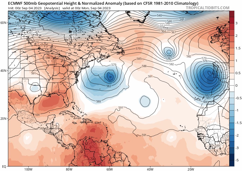
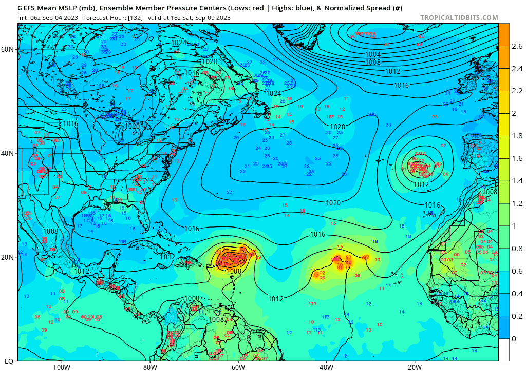
Overnight runs have largely trended toward a powerful hurricane recurving not impacting the islands nor the CONUS (save the GFS which still has the hurricane getting close or impacting the NE CONUS like just one of its ensembles does). The ECMWF 500MB pattern screams recurve and the EPS and GEFS does as well. Check out that signal on the GEFS! 
0 likes
-
MEANINGLESS_NUMBERS
- Category 2

- Posts: 503
- Joined: Mon Nov 02, 2020 1:43 pm
Re: ATL: INVEST 95L - Models
gatorcane wrote:Overnight runs have largely trended toward a powerful hurricane recurving not impacting the islands nor the CONUS (save the GFS which still has the hurricane getting close or impacting the NE CONUS like just one of its ensembles does). The ECMWF 500MB pattern screams recurve and the EPS and GEFS does as well. Check out that signal on the GEFS!
https://i.postimg.cc/Fzz28pW1/ec-fast-z500a-Norm-atl-fh0-240-2.gif
https://i.postimg.cc/1trq2cnx/gfs-ememb-lowlocs-atl-fh132-240.gif
A classic Bermuda hurricane.
0 likes
Emily '87, Felix '95, Gert '99, Fabian '03, Humberto '19, Paulette '20, Teddy '20, Fiona '22, Lee '23, Ernesto '24, Humberto/Imelda '25
-
jconsor
- Professional-Met

- Posts: 577
- Joined: Mon Jun 30, 2008 9:31 pm
- Location: Jerusalem, Israel
- Contact:
Re: ATL: INVEST 95L - Models
Upper pattern across the eastern US and western Atlantic this weekend into next week is far from set in stone. Need to watch the potential for a trough split, which models often don't handle well until inside 5 days.
If the the southern piece of the trough cuts off across the SE US by this weekend, and the ridge over the NW Atlantic/SE Canada is strong enough to resist troughs in the northern stream from progressing eastward much, that could block a typical recurve out to sea.
6Z GEFS and past few GFS runs are now hinting at another trough split mid to late next week from the Great Lakes to the Lower Mississippi/Tennessee Valley. A trough in that position along with an anomalous NW Atlantic ridge has in the past steered many SW Atlantic hurricanes toward a landfall from NC to New England.
https://twitter.com/yconsor/status/1698661249146384450
https://twitter.com/yconsor/status/1698674338080149943
https://twitter.com/yconsor/status/1698689260147126603
https://twitter.com/yconsor/status/1698694330888687972
Last edited by jconsor on Mon Sep 04, 2023 8:52 am, edited 3 times in total.
12 likes

Re: ATL: INVEST 95L - Models
06z HWRF shows rapid genesis and a TS in only about 24-30 hours. While I would write this off as an overly aggressive run, it does initialize the current convective pattern of 95L quite well, so it’s not starting off from an aggressive initialization. The other hurricane models also show genesis in 24-48 hours. We’ll have to see how 95L puts itself together throughout the rest of the day.
2 likes
Irene '11 Sandy '12 Hermine '16 5/15/2018 Derecho Fay '20 Isaias '20 Elsa '21 Henri '21 Ida '21
I am only a meteorology enthusiast who knows a decent amount about tropical cyclones. Look to the professional mets, the NHC, or your local weather office for the best information.
I am only a meteorology enthusiast who knows a decent amount about tropical cyclones. Look to the professional mets, the NHC, or your local weather office for the best information.
-
cheezyWXguy

- Category 5

- Posts: 6280
- Joined: Mon Feb 13, 2006 12:29 am
- Location: Dallas, TX
-
gatorcane
- S2K Supporter
- Posts: 23708
- Age: 48
- Joined: Sun Mar 13, 2005 3:54 pm
- Location: Boca Raton, FL
Re: ATL: INVEST 95L - Models
jconsor wrote:Upper pattern across the eastern US and western Atlantic this weekend into next week is far from set in stone. Need to watch the potential for a trough split, which models often don't handle well until inside 5 days.
If the the southern piece of the trough cuts off across the SE US by this weekend, and the ridge over the NW Atlantic/SE Canada is strong enough to resist troughs in the northern stream from progressing eastward much, that could block a typical recurve out to sea.
6Z GEFS and past few GFS runs are now hinting at another trough split mid to late next week from the Great Lakes to the Lower Mississippi/Tennessee Valley. A trough in that position along with an anomalous NW Atlantic ridge has in the past steered many SW Atlantic hurricanes toward a landfall from NC to New England.
https://twitter.com/yconsor/status/1698661249146384450
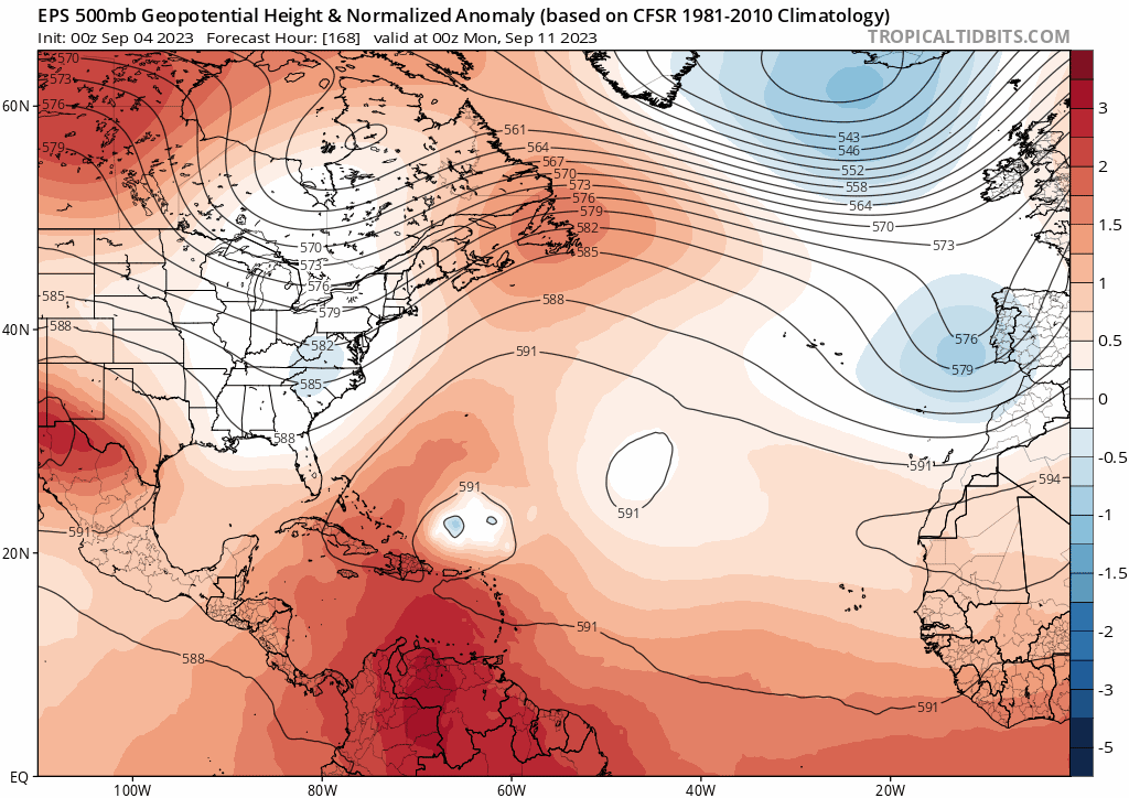
Anything is possible this far out. We do note the EPS and the Euro OP are showing less doubt with pattern. EPS 500MB mean below with lower height anomalies down the entire east coast of the US and those combined with the fact it could be a major hurricane suggests it wouldn’t take much of a weakness to turn it north before it can get close to the US coastline:
1 likes
-
jconsor
- Professional-Met
- Posts: 577
- Joined: Mon Jun 30, 2008 9:31 pm
- Location: Jerusalem, Israel
- Contact:
Re: ATL: INVEST 95L - Models
Hi Larry, very important point you make that the possibility of a rare event shouldn't be dismissed this far out.
When you say eastern MDR, what is the longitude cutoff you are using? I personally find that systems that didn't become a TS until 45W lead to significantly increased odds of at least making it west of 70W, meaning a decent chance of impacting Bahamas and typically a fairly close miss for the East Coast. Recent examples include Irene in 2011, Bertha in 2014, Maria in 2017, Dorian in 2019, and Fiona last year. Also included are several E Coast hurricane hits like Gloria in 1985, Fran in 1996, Bonnie in 1998 and Floyd in 1999.
The counter-examples which formed E of 40W and stayed at or east of 70W (with many staying E of 60W) include Bill 2009, Igor 2010, Katia 2011, Gaston 2016, Helene 2018, Lorenzo 2019, Teddy 2020, Larry and Sam 2021. Earl 2010 and Jose 2017 got to 75W and 73W, respectively, but still stayed off the East Coast.
LarryWx wrote:mantis83 wrote:LarryWx wrote:0Z Euro fits in well with the consensus of the last couple of EPS runs with a recurve near 67W and no land hit though it might have gotten close to Bermuda might had the run continued.
yup, a safe recurve well east of the coast is looking more and more likely
Climo heavily favors a miss of the CONUS from a TCG in the E MDR in Sept, especially with it not La Niña. Climo based odds are somewhere around 80% of no CONUS hit, easily the best bet. However, the problem this far out, especially with no TC center to track yet, is that nobody knows for sure that this won't be one of the 20% that do hit. It isn't as if the chance were something tiny like 5%. Also, if TCG doesn't occur until the W MDR, then that 80% stat becomes irrelevant.
Over the next few days we should get a clearer picture. We need to make sure that this won't be a pretty rare long tracking Sep El Niño US hit like Florence of 2018, Ivan of 2004, and Frederic of 1979. Granted, those three were all during a weak El Niño. However, 2023's much stronger El Nino has yet to act much like one.
One thing I will say about the GFS is that it may have a left bias these days based on how it did with Ian and Idalia. Any thoughts about this?
Edit: 0Z UKMET (goes out 168 hours) is nearly identical to its prior run trackwise though it is weaker. 0Z EPS is pretty similar to its prior couple of runs strongly favoring no NE Caribbean, Bahamas, or CONUS hit.

4 likes
-
cycloneye

- Admin

- Posts: 149219
- Age: 69
- Joined: Thu Oct 10, 2002 10:54 am
- Location: San Juan, Puerto Rico
Re: ATL: INVEST 95L - Models
1 likes
Visit the Caribbean-Central America Weather Thread where you can find at first post web cams,radars
and observations from Caribbean basin members Click Here
and observations from Caribbean basin members Click Here
-
jlauderdal
- S2K Supporter
- Posts: 7240
- Joined: Wed May 19, 2004 5:46 am
- Location: NE Fort Lauderdale
- Contact:
Re: ATL: INVEST 95L - Models
cycloneye wrote:https://twitter.com/dmorris9661/status/1698652317594108248
Keeping it north for cycloneye, msbee and others, good trend today.
2 likes
-
Spacecoast

- Category 2
- Posts: 773
- Joined: Thu Aug 31, 2017 2:03 pm


Re: ATL: INVEST 95L - Models
This is quite ominous given how global models underestimated Franklin by like 20-30 mb.
... And then there's this.
... And then there's this.
2 likes
TC naming lists: retirements and intensity
Most aggressive Advisory #1's in North Atlantic (cr. kevin for starting the list)
Most aggressive Advisory #1's in North Atlantic (cr. kevin for starting the list)
-
ScottNAtlanta

- Category 5
- Posts: 2535
- Joined: Sat May 25, 2013 3:11 pm
- Location: Atlanta, GA
Re: ATL: INVEST 95L - Models
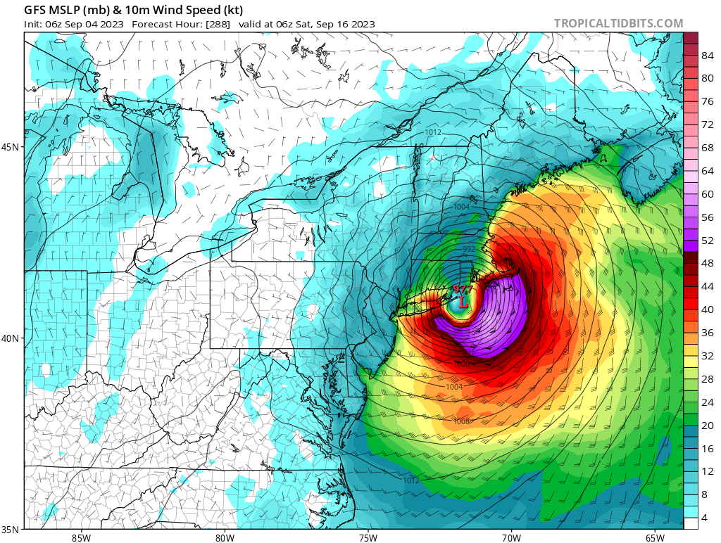
The 6z GFS is the nightmare scenario for NYC. If the GFS were to verify, it would make Sandy look like a walk in the park. I have a very hard time buying into the Euro for the simple reason it has been horrid with the post-tropical Idalia evolution which the GFS has had a better handle on. This is still far out, but don't any of you for one second go calling this a fish or a hit. Both are possible, but in my opinion and from what I see, it is going to be a very close call for something extremely disruptive.
6 likes
The posts in this forum are NOT official forecast and should not be used as such. They are just the opinion of the poster and may or may not be backed by sound meteorological data. They are NOT endorsed by any professional institution or storm2k.org. For official information, please refer to the NHC and NWS products.
Re: ATL: INVEST 95L - Models
jconsor wrote:Hi Larry, very important point you make that the possibility of a rare event shouldn't be dismissed this far out.
When you say eastern MDR, what is the longitude cutoff you are using? I personally find that systems that didn't become a TS until 45W lead to significantly increased odds of at least making it west of 70W, meaning a decent chance of impacting Bahamas and typically a fairly close miss for the East Coast. Recent examples include Irene in 2011, Bertha in 2014, Maria in 2017, Dorian in 2019, and Fiona last year. Also included are several E Coast hurricane hits like Gloria in 1985, Fran in 1996, Bonnie in 1998 and Floyd in 1999.
The counter-examples which formed E of 40W and stayed at or east of 70W (with many staying E of 60W) include Bill 2009, Igor 2010, Katia 2011, Gaston 2016, Helene 2018, Lorenzo 2019, Teddy 2020, Larry and Sam 2021. Earl 2010 and Jose 2017 got to 75W and 73W, respectively, but still stayed off the East Coast.LarryWx wrote:mantis83 wrote:yup, a safe recurve well east of the coast is looking more and more likely
Climo heavily favors a miss of the CONUS from a TCG in the E MDR in Sept, especially with it not La Niña. Climo based odds are somewhere around 80% of no CONUS hit, easily the best bet. However, the problem this far out, especially with no TC center to track yet, is that nobody knows for sure that this won't be one of the 20% that do hit. It isn't as if the chance were something tiny like 5%. Also, if TCG doesn't occur until the W MDR, then that 80% stat becomes irrelevant.
Over the next few days we should get a clearer picture. We need to make sure that this won't be a pretty rare long tracking Sep El Niño US hit like Florence of 2018, Ivan of 2004, and Frederic of 1979. Granted, those three were all during a weak El Niño. However, 2023's much stronger El Nino has yet to act much like one.
One thing I will say about the GFS is that it may have a left bias these days based on how it did with Ian and Idalia. Any thoughts about this?
Edit: 0Z UKMET (goes out 168 hours) is nearly identical to its prior run trackwise though it is weaker. 0Z EPS is pretty similar to its prior couple of runs strongly favoring no NE Caribbean, Bahamas, or CONUS hit.
Your thinking is similar. Last night I was analyzing those storms that had TCG (TD+) E of 40W during (incoming) El Niño seasons with most of their existence within Sep. I didn't count Frances of 2004 because it was already past 65W on Sep 1st. I didn't count David of 1979 because it was already over Haiti on Sep 1st. If it were to look like 95L were to wait til after 40W to become a TD, I might reanalyze by including, say, those with TCG between 40W and 50W.
Last edited by LarryWx on Mon Sep 04, 2023 10:33 am, edited 1 time in total.
0 likes
Personal Forecast Disclaimer:
The posts in this forum are NOT official forecasts and should not be used as such. They are just the opinion of the poster and may or may not be backed by sound meteorological data. They are NOT endorsed by any professional institution or storm2k.org. For official information, please refer to the NHC and NWS products.
The posts in this forum are NOT official forecasts and should not be used as such. They are just the opinion of the poster and may or may not be backed by sound meteorological data. They are NOT endorsed by any professional institution or storm2k.org. For official information, please refer to the NHC and NWS products.
Re: ATL: INVEST 95L - Models
Spacecoast wrote:06z EPS:
https://i.ibb.co/vCWT0hJ/ef68.jpg
Thanks for posting. These (as of 144 on 6Z EPS) are similar to 150 on 0Z EPS. The recurving members start mainly ~18-24 hours later.
0 likes
Personal Forecast Disclaimer:
The posts in this forum are NOT official forecasts and should not be used as such. They are just the opinion of the poster and may or may not be backed by sound meteorological data. They are NOT endorsed by any professional institution or storm2k.org. For official information, please refer to the NHC and NWS products.
The posts in this forum are NOT official forecasts and should not be used as such. They are just the opinion of the poster and may or may not be backed by sound meteorological data. They are NOT endorsed by any professional institution or storm2k.org. For official information, please refer to the NHC and NWS products.
-
emeraldislenc
- Category 2
- Posts: 601
- Joined: Fri Aug 24, 2012 4:49 pm
- Location: Emerald Isle NC
Re: ATL: INVEST 95L - Models
It is almost like a game as who calls fish or recurve first! Let's see where it forms first.
1 likes
Re: ATL: INVEST 95L - Models
emeraldislenc wrote:It is almost like a game as who calls fish or recurve first! Let's see where it forms first.
As I see it, it isn't a game but more of an ongoing analysis that makes for good quality forecasting discussions. Due to inherent everpresent uncertainties, I like to use percentage chances this early on based on many decades of history as opposed to making a definitive call like fish, recurve, hit, dissipation over open water, or whatever. As the event gets closer and closer, these % chances continually change. If there weren't the inherent uncertainties, these forecast discussions wouldn't be nearly as interesting since there'd be little or nothing to discuss as regards what might happen.
6 likes
Personal Forecast Disclaimer:
The posts in this forum are NOT official forecasts and should not be used as such. They are just the opinion of the poster and may or may not be backed by sound meteorological data. They are NOT endorsed by any professional institution or storm2k.org. For official information, please refer to the NHC and NWS products.
The posts in this forum are NOT official forecasts and should not be used as such. They are just the opinion of the poster and may or may not be backed by sound meteorological data. They are NOT endorsed by any professional institution or storm2k.org. For official information, please refer to the NHC and NWS products.
-
cycloneye
- Admin
- Posts: 149219
- Age: 69
- Joined: Thu Oct 10, 2002 10:54 am
- Location: San Juan, Puerto Rico
Re: ATL: INVEST 95L - Models
ICON blows it up to cat 2 moving just north of islands.

1 likes
Visit the Caribbean-Central America Weather Thread where you can find at first post web cams,radars
and observations from Caribbean basin members Click Here
and observations from Caribbean basin members Click Here
-
Hypercane_Kyle

- Category 5
- Posts: 3465
- Joined: Sat Mar 07, 2015 7:58 pm
- Location: Cape Canaveral, FL
Re: ATL: INVEST 95L - Models
The last time I saw the intensity models this geared up over a MDR system was Sam in 2021.
1 likes
My posts are my own personal opinion, defer to the National Hurricane Center (NHC) and other NOAA products for decision making during hurricane season.
Re: ATL: INVEST 95L - Models
12z GFS has a hurricane as early as Wednesday afternoon.
0 likes
Irene '11 Sandy '12 Hermine '16 5/15/2018 Derecho Fay '20 Isaias '20 Elsa '21 Henri '21 Ida '21
I am only a meteorology enthusiast who knows a decent amount about tropical cyclones. Look to the professional mets, the NHC, or your local weather office for the best information.
I am only a meteorology enthusiast who knows a decent amount about tropical cyclones. Look to the professional mets, the NHC, or your local weather office for the best information.
Who is online
Users browsing this forum: No registered users and 8 guests