https://x.com/tbrite89/status/1969315715824955493
NATL: GABRIELLE - Post-Tropical - Discussion
Moderator: S2k Moderators
-
Hurricane2022

- Category 5

- Posts: 2092
- Joined: Tue Aug 23, 2022 11:38 pm
- Location: Araçatuba, Brazil
Re: NATL: GABRIELLE - Tropical Storm - Discussion
6 likes
Sorry for the bad English sometimes...!
For reliable and detailed information for any meteorological phenomenon, please consult the National Hurricane Center, Joint Typhoon Warning Center , or your local Meteo Center.
--------
ECCE OMNIA NOVA FACIAM (Ap 21,5).
For reliable and detailed information for any meteorological phenomenon, please consult the National Hurricane Center, Joint Typhoon Warning Center , or your local Meteo Center.
--------
ECCE OMNIA NOVA FACIAM (Ap 21,5).
-
Category5Kaiju

- Category 5
- Posts: 4345
- Joined: Thu Dec 24, 2020 12:45 pm
- Location: Seattle during the summer, Phoenix during the winter
Re: NATL: GABRIELLE - Tropical Storm - Discussion
Welp....another example of, "just because a storm looks crappy now doesn't mean it will a day later." 
5 likes
Unless explicitly stated, all information in my posts is based on my own opinions and observations. Tropical storms and hurricanes can be extremely dangerous. Refer to an accredited weather research agency or meteorologist if you need to make serious decisions regarding an approaching storm.
-
StormWeather

- Category 1

- Posts: 477
- Joined: Wed Jun 05, 2024 2:34 pm
Re: NATL: GABRIELLE - Tropical Storm - Discussion
Category5Kaiju wrote:Welp....another example of, "just because a storm looks crappy now doesn't mean it will a day later."
It looks like a high end tropical storm now, and I wonder what recon will find when they get there.
0 likes
Just an average cyclone tracker
The posts in this forum are NOT official forecasts and should not be used as such. They are just the opinion of the poster and may or may not be backed by sound meteorological data. They are NOT endorsed by any professional institution or storm2k.org. For official information, please refer to the NHC and NWS products
The posts in this forum are NOT official forecasts and should not be used as such. They are just the opinion of the poster and may or may not be backed by sound meteorological data. They are NOT endorsed by any professional institution or storm2k.org. For official information, please refer to the NHC and NWS products

Re: NATL: GABRIELLE - Tropical Storm - Discussion
Surely not 45kts anymore.
2 likes
Igor 2010, Sandy 2012, Fay 2014, Gonzalo 2014, Joaquin 2015, Nicole 2016, Humberto 2019, Imelda 2025
I am only a tropical weather enthusiast. My predictions are not official and may or may not be backed by sound meteorological data. For official information, please refer to the NHC and NWS products.
I am only a tropical weather enthusiast. My predictions are not official and may or may not be backed by sound meteorological data. For official information, please refer to the NHC and NWS products.
-
StormWeather
- Category 1
- Posts: 477
- Joined: Wed Jun 05, 2024 2:34 pm
Re: NATL: GABRIELLE - Tropical Storm - Discussion
Kazmit wrote:Surely not 45kts anymore.
Yeah, I’m thinking 50-55 kts right now, but we will see what recon finds.
0 likes
Just an average cyclone tracker
The posts in this forum are NOT official forecasts and should not be used as such. They are just the opinion of the poster and may or may not be backed by sound meteorological data. They are NOT endorsed by any professional institution or storm2k.org. For official information, please refer to the NHC and NWS products
The posts in this forum are NOT official forecasts and should not be used as such. They are just the opinion of the poster and may or may not be backed by sound meteorological data. They are NOT endorsed by any professional institution or storm2k.org. For official information, please refer to the NHC and NWS products

Re: NATL: GABRIELLE - Tropical Storm - Discussion
3 likes
TC naming lists: retirements and intensity
Most aggressive Advisory #1's in North Atlantic (cr. kevin for starting the list)
Most aggressive Advisory #1's in North Atlantic (cr. kevin for starting the list)
-
StormWeather
- Category 1
- Posts: 477
- Joined: Wed Jun 05, 2024 2:34 pm
Re: NATL: GABRIELLE - Tropical Storm - Discussion
Outflow to the north looks like it’s getting better defined and I can some spiraling going on. This storm definitely has the look of a slow-going intensifying storm atm.
2 likes
Just an average cyclone tracker
The posts in this forum are NOT official forecasts and should not be used as such. They are just the opinion of the poster and may or may not be backed by sound meteorological data. They are NOT endorsed by any professional institution or storm2k.org. For official information, please refer to the NHC and NWS products
The posts in this forum are NOT official forecasts and should not be used as such. They are just the opinion of the poster and may or may not be backed by sound meteorological data. They are NOT endorsed by any professional institution or storm2k.org. For official information, please refer to the NHC and NWS products
-
Sciencerocks
- Category 5
- Posts: 10193
- Age: 40
- Joined: Thu Jul 06, 2017 1:51 am

-
Hurricane2022
- Category 5
- Posts: 2092
- Joined: Tue Aug 23, 2022 11:38 pm
- Location: Araçatuba, Brazil
Re: NATL: GABRIELLE - Tropical Storm - Discussion
Cool

5 likes
Sorry for the bad English sometimes...!
For reliable and detailed information for any meteorological phenomenon, please consult the National Hurricane Center, Joint Typhoon Warning Center , or your local Meteo Center.
--------
ECCE OMNIA NOVA FACIAM (Ap 21,5).
For reliable and detailed information for any meteorological phenomenon, please consult the National Hurricane Center, Joint Typhoon Warning Center , or your local Meteo Center.
--------
ECCE OMNIA NOVA FACIAM (Ap 21,5).


Re: NATL: GABRIELLE - Tropical Storm - Discussion
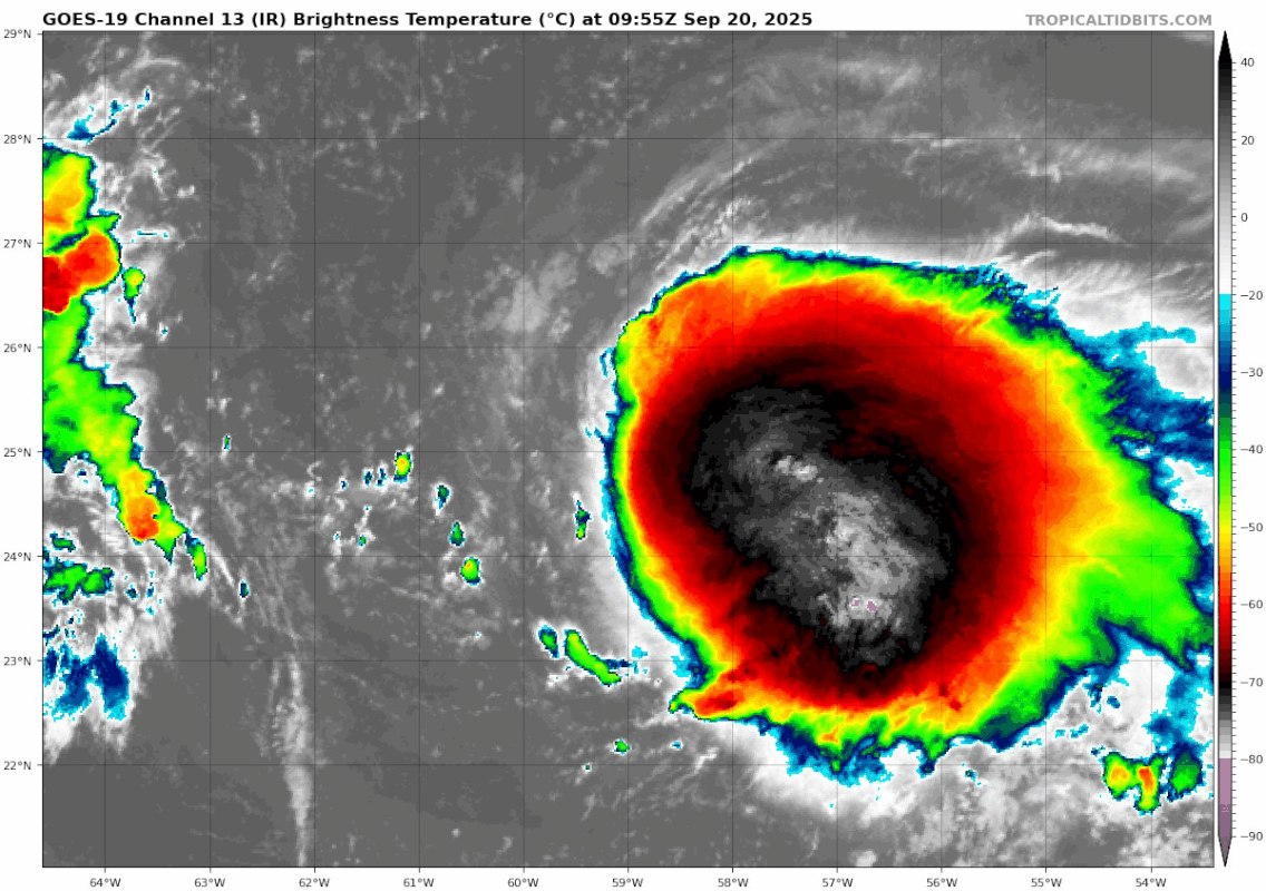
Hmmm, looks like the beginning of a pinhole eye - 24.95 N and 58.50 W (give or take a hundred feet or so). That along with a new tower going off right of center
0 likes
Andy D
(For official information, please refer to the NHC and NWS products.)
(For official information, please refer to the NHC and NWS products.)


Re: NATL: GABRIELLE - Tropical Storm - Discussion
Looks to be about 998mb and 50-55kts per recon so far.
I'm interested in what the winds look like in the NE.
154900 2456N 05832W 7515 02492 9979 +174 +105 136008 016 /// /// 03
155030 2455N 05826W 7528 02510 0062 +128 +149 211055 059 /// /// 05
155030 2455N 05826W 7528 02510 0062 +128 +149 211055 059 /// /// 05
I'm interested in what the winds look like in the NE.
2 likes
-
StormWeather
- Category 1
- Posts: 477
- Joined: Wed Jun 05, 2024 2:34 pm
Re: NATL: GABRIELLE - Tropical Storm - Discussion
chaser1 wrote:Hmmm, looks like the beginning of a pinhole eye - 24.95 N and 58.50 W (give or take a hundred feet or so). That along with a new tower going off right of center
Erin-redux much?
1 likes
Just an average cyclone tracker
The posts in this forum are NOT official forecasts and should not be used as such. They are just the opinion of the poster and may or may not be backed by sound meteorological data. They are NOT endorsed by any professional institution or storm2k.org. For official information, please refer to the NHC and NWS products
The posts in this forum are NOT official forecasts and should not be used as such. They are just the opinion of the poster and may or may not be backed by sound meteorological data. They are NOT endorsed by any professional institution or storm2k.org. For official information, please refer to the NHC and NWS products

Re: NATL: GABRIELLE - Tropical Storm - Discussion
It's interesting how the system seems/seemed large in it's formative stages, but the GFS model forecasts at peak intensity/closest approach to be a pretty small system, at least it's wind field. The NWS is talking about large swells affecting the East Coast of the US but the current swell models, and this small scale windfield suggest otherwise.

2 likes
Re: NATL: GABRIELLE - Tropical Storm - Discussion
Yeah, quite a different storm structure then Erin. Shouldn't result in anything close to the coastal impacts that Erin had. Erin's wind field was huge and well established for a greater duration of time than Gabrielle will have, prior to being caught and diverted northeastward by the Westerlies.
0 likes
Andy D
(For official information, please refer to the NHC and NWS products.)
(For official information, please refer to the NHC and NWS products.)
Re: NATL: GABRIELLE - Tropical Storm - Discussion
Kazmit wrote:Surely not 45kts anymore.
Nothing like a little RI before lunch
What time is recon estimated to arrive? Right now I'd guess winds to be 90 mph, perhaps higher.
1 likes
Andy D
(For official information, please refer to the NHC and NWS products.)
(For official information, please refer to the NHC and NWS products.)

Re: NATL: GABRIELLE - Tropical Storm - Discussion
chaser1 wrote:Kazmit wrote:Surely not 45kts anymore.
Nothing like a little RI before lunch
What time is recon estimated to arrive? Right now I'd guess winds to be 90 mph, perhaps higher.
Recon is in-storm and has only measured 60-kt flight level winds and a central pressure (extrap.) of 998 hPa as of the first center pass. Gabrielle is intensifying, but I'm not seeing much indication of RI at the moment.
1 likes
Re: NATL: GABRIELLE - Tropical Storm - Discussion
I expect NHC to put out a Special Update advisory fairly soon for Gabrielle being upgraded to a hurricane (prior to recon reaching the center).
0 likes
Andy D
(For official information, please refer to the NHC and NWS products.)
(For official information, please refer to the NHC and NWS products.)
Re: NATL: GABRIELLE - Tropical Storm - Discussion
sasha_B wrote:chaser1 wrote:Kazmit wrote:Surely not 45kts anymore.
Nothing like a little RI before lunch
What time is recon estimated to arrive? Right now I'd guess winds to be 90 mph, perhaps higher.
Recon is in-storm and has only measured 60-kt flight level winds and a central pressure (extrap.) of 998 hPa as of the first center pass. Gabrielle is intensifying, but I'm not seeing much indication of RI at the moment.
Hmmm, I've got to wonder whether their pass was east of the apperant eye?
0 likes
Andy D
(For official information, please refer to the NHC and NWS products.)
(For official information, please refer to the NHC and NWS products.)
-
cheezyWXguy

- Category 5
- Posts: 6282
- Joined: Mon Feb 13, 2006 12:29 am
- Location: Dallas, TX
Re: NATL: GABRIELLE - Tropical Storm - Discussion
I don’t know how likely it is that Gabrielle retains a core that small, given that they tend to be very vulnerable to collapse if conditions aren’t perfect, and it’s currently rather weak on the southwest side. That said, even if the small core does collapse I wouldn’t expect a new core to be very large, and given the smaller size I think Gabrielle does have a chance to overperform. No question its appearance has significantly improved since yesterday and the lightning near the core suggests it continues to not waste time.
2 likes
-
cycloneye

- Admin

- Posts: 149710
- Age: 69
- Joined: Thu Oct 10, 2002 10:54 am
- Location: San Juan, Puerto Rico
Re: NATL: GABRIELLE - Tropical Storm - Discussion
1 likes
Visit the Caribbean-Central America Weather Thread where you can find at first post web cams,radars
and observations from Caribbean basin members Click Here
and observations from Caribbean basin members Click Here
Who is online
Users browsing this forum: No registered users and 61 guests